Blog

  • Distracted Driving Device Allows GPS Functionality While Driving

    TextBuster_largeTextBuster, a device by Access 2 Communications that prevents drivers from accessing text, email and Internet functions while driving, allows GPS to function while driving.

    It does not interfere with inbound and outbound calling. The firmware technology behind TextBuster sends a blocking signal to the user’s phone automatically, every time the user enters the vehicle.

    TextBuster will not interfere with any other hands-free or Bluetooth items in the vehicle, according to the company. It is a patent-pending device that will disable the data functions to the driver’s phone only while inside the vehicle without interfering with inbound and outbound calls. It includes two components, the mobile app, which is a free download, and a small “brain box” that is mounted under the dash.

    Ohio-based Access 2 Communications developed the distracted driving device with the hopes of significantly reducing the number of preventable distracted driving fatalities worldwide.

    TextBuster will be available in Target stores nationwide starting in mid-November, according to TextBuster.

  • PCTEL Offers Two New Fleet Management Antennas

    PCTEL Offers Two New Fleet Management Antennas

    PCTEL-antennas-fleets

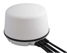
    PCTEL has introduced two new fleet-management antennas intended to make high-speed data communications easier. The high-performance antennas include LTE, Wi-Fi, and GPS capabilities in a single low-profile housing.

    The first new antenna is a magnetic-mount version of PCTEL’s 5-port multiband fleet management antenna, designed to support temporary installations such as rental vehicle fleets. The 5-port GPS and communications antenna provides outstanding performance for critical fleet management applications, PCTEL said.

    LTE MIMO, GPS Multiband Antenna with Magnetic Base
    LTE MIMO, GPS Multiband Antenna with Magnetic Base

    Features of the LTE MIMO, GPS Multiband Antenna with Magnetic Base include:

    • Optimal 4G LTE MIMO and dual-band 802.11n Wi-Fi
    • High rejection GPS LNA assembly
    • Low-profile housing in white or black
    • An IP67-compliant design
    • High-performance, low loss cable and high-quality connectors
    • Rare earth magnets for outstanding pull force resistance

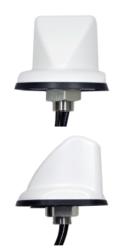
    The second new antenna is a sleeker, more aerodynamic fleet-management antenna designed for public safety or other vehicular applications requiring a smaller footprint, making it PCTEL’s most compact multiband GPS and communications option.

    LTE, Dual 802.11n, GPS Multiband Antenna
    LTE, Dual 802.11n, GPS Multiband Antenna

    Features of the LTE, Dual 802.11n, GPS Multiband Antenna include:

    • Optimal 4G LTE and dual-band 802.11n Wi-Fi
    • High Rejection GPS LNA assembly
    • Aerodynamic, compact, UV-resistant housing in white or black
    • IP67 compliant design
    • High-performance, low loss cable and high-quality connectors

    Both new magnetic-mount antennas are now available for shipment. New smaller footprint antennas will be available in March.

  • CompassData Granted ISO Certification for Quality-Management Systems

    CompassData, a worldwide provider of geospatial data and services, has received ISO 9001:2008 Certification for Quality Management Systems from Orion Registrar Inc.. The ISO 9001:2008 certification is well established in the United States and around the world as a quality-management system tool.

    CompassData completed a rigorous audit in which Orion Registrar reviewed each step in the firm’s quality-management methodologies used during the creation of GPS-surveyed ground control and other geospatial products such as orthorectified imagery, digital elevation models (DEM), sensor calibrations and GIS map products.

    This certification recognizes that CompassData has established a quality-management system that addresses the scope of the company’s core processes: supplying ground-control points and other high-accuracy products, services and content for the geospatial community. Superior ability to capture and satisfy customer requirements was a key element in the demonstration of the quality-management system to the registrar.

    “CompassData has set itself apart by becoming one of the few geospatial survey data providers in the world whose quality-management systems and processes are ISO 9001 certified,” the company said in a statement.

    ISO (International Organization for Standardization), the supplier of the ISO 9000 family of quality and management standards, is a network of national standards institutes from 163 countries working in partnership with international governments, organizations, businesses and consumer representatives.

    The ISO 9000 quality-management standards are designed to help organizations ensure that they meet the needs of customers and other stakeholders while meeting regulatory requirements related to a product. More than one million organizations worldwide are independently certified, making ISO 9001 one of the most widely used management tools in the world today.

    “This certification assures our customers of our commitment to meeting their needs by using standardized procedures that have been independently verified as being in conformity with ISO 9001:2008 requirements,” said Doug Braddock, CompassData’s quality manager.  “Our customers will know that the product they receive from us has been created in an environment where internal processes are consistent and continually improving.”

  • DigitalGlobe’s Geospatial Big Data Platform Enabling New Commercial Solutions

    DigitalGlobe, Inc., has agreed to provide another commercial customer access to its Geospatial Big Data (GBD) platform, paving the way for new analytic products serving the insurance, forestry, oil & gas, and mining industries, the company said.

    Exogenesis is a provider of advanced analytics, algorithm development, and predictive modeling and simulation. The company has subscribed to DigitalGlobe’s GBD service to facilitate new product development enabled by large-scale data analysis.

    The agreement includes access to algorithms, expertise, and petabytes of high-resolution satellite imagery collected over the past 15 years. DigitalGlobe customers Orbital Insight and Cuende have also subscribed to the service and are introducing unique products to their commercial markets.

    DigitalGlobe’s cloud-based GBD offering is a “platform as a service” model that provides access to DigitalGlobe’s vast image library. It is designed to create a new ecosystem in which partners and developers can leverage their expertise and API’s to create new customer solutions without the cost of owning and operating costly IT infrastructure, DigitalGlobe said.

    The GBD platform is one of the strategic initiatives propelling DigitalGlobe toward its vision of becoming the indispensable source of information about the planet, the company said.

    “Exogenesis is thrilled to have the opportunity to work with DigitalGlobe, the biggest name in commercial satellite imagery,” said Sean Anklam, president of Exogenesis. “As an early adopter of DigitalGlobe’s Geospatial Big Data platform, we will be able to provide the most advanced decision support information derived from source imagery of the highest quality.”

    “It’s a privilege to bring our Geospatial Big Data capabilities to the market with an innovative partner like Exogenesis,” said Shay Har-Noy, DigitalGlobe’s Senior Director for GBD. “We are committed to investing in Geospatial Big Data in order to create a living digital inventory of the surface of the earth, enabled by our unmatched satellite constellation, commitment to ecosystem partners, and ability to convert imagery at scale into searchable, analytics-ready information layers.”

  • University of Tennessee Hosts Father of Geographic Information Science

    Michael Goodchild, emeritus professor of geography at the University of California, Santa Barbara, will speak on “Space, Place, and GIS” at the University of Tennessee Department of Geography on Feb. 12 in Knoxville.

    Goodchild will deliver the annual Hammond Lecture in the Lindsay Young Auditorium of John C. Hodges Library. A reception will be held at 3 p.m., and the presentation will follow at 3:40 p.m. The event is free and open to the public.

    Goodchild is considered by many to be the father of geographic information science, also known as GIS. He is also widely credited with coining the term volunteered geographic information, which is spatial data that has been contributed for free by volunteers. His research interests focus on geographic information science, spatial analysis, and uncertainty in geographic data.

    Goodchild will explain that modern technology uses concepts of latitude, longitude, and measurements of distance to describe the geographic world. On the other hand, humans think of the geographic world in terms of places and their associations. He will discuss the possibility of “palatial” technology that will combine the two different concepts of geography to fill the gap and help people share geographic knowledge more naturally.

    “It is truly a great honor to have someone of Michael Goodchild’s reputation visit UT and the Department of Geography,” said Derek Alderman, head of the Department of Geography. “GIS has emerged as an important innovation, not just within the discipline of geography, but across the social and natural sciences and the digital humanities.”

    Goodchild will also meet with and mentor graduate and undergraduate students and faculty members to brainstorm the future of geographic information science, and he will assist in efforts to enhance the UT GIS program.

  • Tallysman Wraps Antennas in Armored Cable for Precision Ag, M2M

    Tallysman Wraps Antennas in Armored Cable for Precision Ag, M2M

    This photo shows the corrugated conduit covering the RG174 cable with Tallysman’s TW2410 antenna.
    This photo shows the corrugated conduit covering the RG174 cable with Tallysman’s TW2410 antenna.

    Tallysman’s enclosed antennas now come with optional armored corrugated cable. The standard RG174 cable is encased in a corrugated conduit of tough plastic, which maintains its functionality between the temperatures of -40 to +150C.

    The extra protection increases the resilience of the antenna for use in precision agriculture, machine-to-machine, and other rugged applications.

    Tallysman is a manufacturer of high-performance, high-quality products for a wide range of GNSS applications.

  • Topcon’s Android App Drives LN-100 Layout Navigator

    MAGNET_Construct_field_Topcon-W

    Topcon Positioning Group has released a new app designed to drive the LN-100 Layout Navigator system MAGNET Construct. The no-cost app, available for the Android market, is built to provide “out-of-the-box” productivity with LN-100W hardware.

    “The MAGNET Construct app offers intuitive options to drive an LN-100W for fast as-built measurements as well as graphical guidance to your design data.” said Oscar Cantú, senior manager of product marketing.

    “When combined with the LN-100W, the app provides an entry-level precise measurement solution for diverse 3D layout applications such as traditional construction, complex landscape layout, architecture, as well as quickly checking existing stakeout locations before proceeding on a project,” said Cantú.

    MAGNET Construct offers optional connectivity with MAGNET Enterprise for real-time data exchange from active project sites to and from the office within a user’s private company account.

    MAGNET_-Construct_Topcon-W“The addition of the new MAGNET Construct app exemplifies our focus to keep the LN-100W productive even with bring-your-own-device (BYOD) scenarios.  Android tablets and smartphones wirelessly driving precise hardware, along with secure connectivity to your office keeps projects productive and profitable,” said Cantú.

    MAGNET Construct is currently available for Android users to download for free on the Google Play store.

  • Global Mapper v16.1 Introduces 3D and UAV Video Playback Tools

    Global Mapper version 16.1, what Blue Marble terms an “interim release,” adds a UAV Video Playback Tool, new options to rotate the map view, and the ability to select and measure features in the 3D viewer. It is available for download.

    To introduce the new version, Blue Marble is presenting a free webinar titled “What’s New in Global Mapper v16.1” on February 19 at 2 p.m. EDT.

    The release includes a variety of updates to both the Global Mapper base product and the optional LiDAR Module. A new video playback tool allows users to play a video derived from the flight of an aircraft or UAV. The playback option displays a video file synced to any line feature with per-vertex times, fly-through lines or point features with recognized timestamp attributes.

    Version 16.1 of Global Mapper also offers the option to rotate the map view as needed, allowing the user to more clearly visualize any spatial data with a unique alignment. The automatic “Track Up” mode works when connected to a GPS device and rotates the map view based on the current GPS heading. The new release also introduces the ability to select vector features with the Digitizer tool in the 3D Viewer. This functionality links the 2D and 3D maps, allowing users the option to pan, zoom, measure, and add vector data in one viewer while automatically replicating actions and updating features in the other. The right-click menu enables users to perform many Digitizer operations on the selected features in the 3D window.

    Single-user license upgrades for version 15 are available for $169; upgrades are also available for USB dongles and network licenses. To purchase a dongle or network license upgrade, contact sales at [email protected].

  • Mojio Partners with Dooing to Offer Live Fleet Tracking

    dooing-in-iphone6-171x300Mojio, an open platform for connecting cars, has announced a partnership with Dooing, a new team management platform for businesses that can dispatch jobs and track teams.

    “With Dooing, any business can dispatch jobs and track teams on the move, from three people to thousands,” said David Barton-Grimley, a Mojio developer and co-founder of Dooing. “iOS and Android apps are used to manage field staff, assigning and tracking a job’s life cycle from start to finish with reports on key performance metrics. Enterprises and startups alike can build Dooing into their own products with our API.”

    With the partnership Mojio says businesses can narrow down on fuel consumption, prevent breakdowns with diagnostics insights and track in real time.

    “Mojio is the first platform we’ve integrated into Dooing, enabling Mojio customers to track jobs with live fleet data,” Barton-Grimley said. “Additionally, we’ve added to the ability to track and report on key metrics like fuel consumption and distance traveled down to the specific job.”

    Mojio, the only open-platform connected car device — according to the company — has plans to continue growing its ecosystems of drivers, partners and developers.

  • US Fleet Tracking’s GPS Trackers Aim to Save Money

    US Fleet Tracking‘s GPS trackers allow companies to monitor its fleet drivers’ speeds.

    Monitoring a driver’s speed may reduce the risk of an increase in insurance premiums, ticket costs, and fuel and maintenance costs. The company’s GPS trackers store speeding information, meaning drivers may increase performance knowing their speed is being observed.

  • what3words: A new way to identify any 3-meter location gains traction

    what3words

    what3words (w3w) is such a simple concept that I’m kicking myself for not think of it first. Developed in 2013, what3words is gaining traction with many non-GIS users as a more user-friendly way of identifying locations. It’s a system of 3-meter grid cells covering the Earth’s surface, with each cell identified with a unique three-word group.

    The three words don’t mean anything, but like the phonetic alphabet (Alpha, Bravo, Charlie, Delta…) used in radio communications, the words make it easy to communicate and easy to remember. By contrast, a long string of lat long degrees, minutes and seconds, or MGRS characters are tedious to copy, hard to remember and easy to screw up.

    Additionally, because the w3w cells are small, communicating an exact location is easy. So, if I wanted to meet someone at a large sporting event in the parking lot or particular gate, the unique 3-meter cell puts me face-to-face with my colleague. Since the words follow no particular hierarchy or grouping, an error in one word would be very obvious or show zero return.

    See the video at the what3words website for a full explanation. My guess is that very soon your business card will not only list your address, but the three word location of the right door to enter your building and perhaps even your cubical location, once indoor location technology is perfected.

    My column is short for now because I’ll be attending the Esri Federal GIS Conference in Washington next week.  I’ll be posting video clips from the conference and expo, so watch this space Monday and Tuesday for highlights.

  • Septentrio RTK Receivers Power DigPilot 3D Machine Guidance

    Septentrio RTK Receivers Power DigPilot 3D Machine Guidance

    Septentrio-DigPilotDigPilot, a Norwegian supplier of surveying equipment and instruments for building and construction, has developed a flexible 3D machine guidance system based on Septentrio’s AsteRx2eH OEM GNSS receivers.

    AsteRx2eH is a single-board dual-frequency dual-antenna 272-channel GPS/GLONASS OEM heading receiver, which provides 20-Hz data output of position, heading and pitch/roll data to the machine guidance system. As a member of Septentrio’s AsteRx family of compact OEM boards, the AsteRx2eH receiver is built around the same advanced GNSS chipset and shares the family’s all-in-view GPS and GLONASS tracking and advanced signal processing algorithms for robust tracking and high-precision positioning, even in challenging environments.

    The DigPilot machine guidance system uses wireless technology for all of the installed sensors, instead of being hard-wired into the machine. All the components come packed in a hardened plastic case for transportation from one machine to another. The sensors can be clipped into brackets on the excavator arm and cab and calibrated to the machine and bucket in a matter of minutes, Septentrio said. The operator uses an intuitive graphics display on a rugged touchscreen console to control the arm and shovel following a preloaded grade plan.

    The DigPilot machine guidance systems have been documented to improve on-the-job safety, productivity and quality of work while reducing costs dramatically. With the DigPilot system, companies can move the 3D guidance system around the fleet of construction equipment as needed, at a fraction of the cost of installing hard-wired systems on multiple machines, Septentrio said.

    DigPilot customers are also using APS-3 GNSS RTK receivers from Altus Positioning Systems, a Septentrio company, in conjunction with the on-board machine guidance system for high-precision site surveys and as-builts.

    “With the Septentrio OEM receivers we know we can count on the highest levels of accuracy, reliability, ruggedness and performance,” said Jan Floberg, CEO and founder of DigPilot. “We tested all other available GNSS products on the market before deciding on Septentrio. The AsteRx2eH outperforms the other brands in its ability to obtain and hold fix and heading in the rugged terrain of western Norway. We have deployed over 1,000 systems to date.”

    Altus and Septentrio products will be on display at World of Concrete in Outdoor Booth 032025 at the Las Vegas Convention Center, Feb. 3-6.