A FireWhat Inc. representative talks about its wildfire management techniques at the 2015 Esri Federal GIS Conference, held Feb. 9-10 in Washington D.C. FireWhat is a GIS and Technology company that provides custom tools to map and track assets in and out of the field.
Blog
-
Telstra, Optus, Vodafone Fight Assisted GPS Patent Infringement Claim
Three telecommunications companies are joining together to fight patent-infringement claims involving the use of assisted GPS in their mobile networks, reports ZDNET.
Telstra and Optus are Australian telecommunications and media companies, and Vodafone is based in the United Kingdom.
The claim by Australian company Voxson alleges that the mobile network operators are infringing on two patents held by Voxson since the 1990s. One patent, Vox 1, deals with how customers’ mobile phones are tracked on mobile networks, and forms the basis for the assisted GPS used by the networks to deliver location information to their customers. The other patent, Vox 2, deals with video streaming.
The lawsuit was brought against the three companies in 2013, and the allegations cover the 2G, 3G, and 4G networks of all three carriers.
-
Russia, China Sign Satellite Navigation Agreement

Russia and China have signed a cooperation agreement on satellite navigation, a Russian Space Agency spokesperson told RIA Novosti on Tuesday.
Roscosmos chief Igor Komarov met with Xu Dazhe, the leader of China’s National Space Administration, on an official visit in Beijing.
“The first provision to set up a committee and a protocol were signed during the first working session. Igor Komarov and Xu Dazhe discussed issues of bilateral cooperation in the field of electronic components for rocket construction and building rocket engines,” the spokesperson said.
A Russian-Chinese committee on satellite navigation was established in October 2014 at the meeting between Russia’s Deputy Prime Minister Dmitry Rogozin and his Chinese counterpart, Wang Yang.
In November, China North Industries Corporation (NORINCO) and the Russian GLONASS nonprofit partnership agreed to establish a joint venture to promote worldwide services based on GLONASS and BeiDou.
Russia and China also recently completed joint reconnaissance for the placement of GLONASS differential correction and monitoring stations in the Chinese cities of Urumqi and Changchun. Each country is expected to accommodate three such facilities. -
Trimble’s Pocket-Sized R1 GNSS Receiver Enables Data Collection with Smart Devices
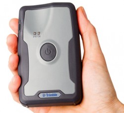
Trimble’s R! GNSS receiver. Trimble has introduced the R1 GNSS receiver, a pocket-sized, rugged, standalone receiver that works with iOS, Android or Window mobile handhelds, smartphones and tablets using Bluetooth connectivity. When paired with a smart device, the receiver adds professional-grade GNSS geo-location capabilities to transform consumer devices into high-accuracy mobile data collection systems.
With the evolution of smartphones and tablets, more field workers now have access to positioning technologies for geospatial data collection. The Trimble R1 GNSS receiver is designed to collect data and inspect or manage assets using smart devices without an integrated high-accuracy GNSS receiver. Adding the optional Trimble ViewPoint RTX correction service to the R1 receiver enables users to achieve reliable sub-meter accuracy, Trimble said.
The Trimble R1 receiver is compact and portable, weighing 6.5 ounces (187 grams). With an all-day battery life, the receiver can be carried in a vest pocket, attached to a belt using the optional belt pouch, or pole mounted. The receiver also integrates with Trimble TerraFlex, Trimble TerraSync and Trimble Positions mapping and Geographic Information System (GIS) field software.
“The addition of the R1 GNSS receiver expands our portfolio to address the needs of organizations that have adopted a workplace Bring Your Own Device (BYOD) strategy for their businesses. We are providing an innovative solution to enable next generation capabilities for a much broader base of field workers to collect high-accuracy geospatial data,” said Alain Samaha, business area director of GIS and Software for Trimble’s Geospatial Division. “Our focus is to provide customers with a variety of options and flexibility when it comes to mobile device deployment and authoritative data collection to increase productivity and improve operations.”
The Trimble R1 GNSS is a multi-constellation receiver that supports GPS, GLONASS, Galileo, BeiDou and QZSS satellite signals. The Trimble ViewPoint RTX corrections are delivered via cellular data network coverage or over satellite in remote locations — without the need for a traditional base station or VRS network — when using Trimble’s Mapping & GIS software or API. In addition, the R1 receiver can leverage SBAS and VRS correction sources to achieve sub-meter accuracy.
Trimble TerraFlex is a scalable cloud-based solution for geospatial data collection. TerraFlex addresses a wide variety of field requirements including attribute-rich GIS data collection on professional and consumer devices.
-
PenBay Solutions Debuts InVision 2.0
PenBay Solutions, a developer of GIS-based facility management and public safety software, is introducing InVision 2.0 at the 2015 Esri Federal GIS Conference, held Feb. 9-10 in Washington, D.C.
Built on the Esri ArcGIS platform, PenBay Solutions has developed the InVision software suite to cohesively address a full range of facility management needs, from strategic portfolio planning and management, to day-to-day operations, maintenance, and safety and security. InVision helps users solve both tactical and strategic challenges throughout the facility lifecycle driving measurable results in portfolio performance, facility management and risk mitigation, according to the company.
 InVision 2.0 focuses on new and expanded capabilities for mobile viewing and editing workflows, analysis and reporting, and data authoring and interoperability.
The new InVision Mobile Viewer is an HTML5/JavaScript viewer that is designed to work with most mobile devices. Users can leverage the InVision Mobile Viewer to securely deliver a variety of facilities data to other InVision users via smart phones and tablets. The viewer allows users to search across the portfolio, moving between the indoors and outdoors, displaying different views of information that may be linked to or related to features of interest on the map. Some common uses of the InVision Mobile Viewer include:
- helping a campus community find points of interest, buildings, spaces, etc. across the portfolio;
- securely viewing space assignments to better understand the allocation of spaces to individuals and departments;
- managing the location of assets and access information linked to those assets in the field; and
- securely sharing emergency plans out in the field.
 The InVision Mobile Inspector — also an HTML /JavaScript web application — is designed to help users inventory and inspect assets throughout the facility portfolio. InVision Mobile Inspector allows users to go out in the field and inventory all manner of items, create inspection records associated to those items, capture photos to attach to the items and upload files to attach to the items.
InVision 2.0 also features InVision CADs, Data Interoperability Workbenches, InVision Home and FISDM Support.
“Collectively, InVision 2.0’s new capabilities deliver more value so our customers can better manage their most critical facilities-related business challenges,” said Stu Rich, CTO for PenBay Solutions. “2.0 is also setting the table for another round of incredible new features and solutions that we plan to release later this year.”
The new technology will be featured in the company’s booth, #325, and at the facility management conference track in room 102B at the Walter E. Washington Convention Center on Feb. 10.
-
PenBay Solutions Debuts InVision 2.0 at Esri Federal GIS Conference
PenBay Solutions, a developer of GIS-based facility management and public safety software, is introducing InVision 2.0 at the 2015 Esri Federal GIS Conference, held Feb. 9-10 in Washington, D.C.
Built on the Esri ArcGIS platform, PenBay Solutions has developed the InVision software suite to cohesively address a full range of facility management needs, from strategic portfolio planning and management, to day-to-day operations, maintenance, and safety and security. InVision helps users solve both tactical and strategic challenges throughout the facility lifecycle driving measurable results in portfolio performance, facility management and risk mitigation, according to the company.
 InVision 2.0 focuses on new and expanded capabilities for mobile viewing and editing workflows, analysis and reporting, and data authoring and interoperability.
The new InVision Mobile Viewer is an HTML5/JavaScript viewer that is designed to work with most mobile devices. Users can leverage the InVision Mobile Viewer to securely deliver a variety of facilities data to other InVision users via smart phones and tablets. The viewer allows users to search across the portfolio, moving between the indoors and outdoors, displaying different views of information that may be linked to or related to features of interest on the map. Some common uses of the InVision Mobile Viewer include:
- helping a campus community find points of interest, buildings, spaces, etc. across the portfolio;
- securely viewing space assignments to better understand the allocation of spaces to individuals and departments;
- managing the location of assets and access information linked to those assets in the field; and
- securely sharing emergency plans out in the field.
 The InVision Mobile Inspector — also an HTML /JavaScript web application — is designed to help users inventory and inspect assets throughout the facility portfolio. InVision Mobile Inspector allows users to go out in the field and inventory all manner of items, create inspection records associated to those items, capture photos to attach to the items and upload files to attach to the items.
InVision 2.0 also features InVision CADs, Data Interoperability Workbenches, InVision Home and FISDM Support.
“Collectively, InVision 2.0’s new capabilities deliver more value so our customers can better manage their most critical facilities-related business challenges,” said Stu Rich, CTO for PenBay Solutions. “2.0 is also setting the table for another round of incredible new features and solutions that we plan to release later this year.”
The new technology will be featured in the company’s booth, #325, and at the facility management conference track in room 102B at the Walter E. Washington Convention Center on Feb. 10.
-
Pufferfish Spherical Display System Integrates Esri ArcGIS Runtime
Pufferfish, a multitouch digital display technology company, displays its PufferSphere product at the 2015 Esri Federal GIS Conference, held Feb. 9-10 in Washington, D.C. PufferSphere is spherical, 360-degree display system made for multinational corporations, public and private institutions. It is innovating the understanding of trends, phenomena and correlations in global data.
-
Remote GeoSystems LineVision Software Maps Geospatial Video
Art Kalinski, GeoIntelligence Insider editor, reports on Remote GeoSystems‘ geospatial DVR at the 2015 Esri Federal GIS Conference, held Feb. 9-10 in Washington, D.C. LineVision Esri ArcGIS is a stand-alone desktop software that leverages Esri GIS technology to map, analyze and package geospatial full motion video, photos, annotations, documents, SHP files and raster imagery from the geospatial DVR.
-
USGIF’s GEOINT 2015 Aims for New Government Agency Attendees
The United States Geospatial Intelligence Foundation (USGIF) has revealed the theme for its GEOINT 2015 Symposium while at the Esri Federal GIS Conference, held Feb. 9-10 in Washington, D.C. GEOINT 2015 will be themed as “Opening the Aperture: Charting a Path to the Future” to engage government agencies that have not attended before. It will take place June 22-25, also in Washington, D.C.
-
Delta Rocket Moves to Launchpad for March GPS Launch
The Delta 4 rocket that will launch the next GPS satellite has been rolled out to the launch pad, reports Spaceflight Now. The satellite itself, GPS IIF-9, will be attached to the rocket in March. The United Launch Alliance vehicle is scheduled for launch March 25.
The launch will be the 371st Delta rocket since 1960 and the 29th Delta 4 since 2002. It also marks the 69th GPS satellite launch and the 55th to use a Delta rocket.
-
Report Looks at Feeding Growing Global Population with Precision Farming, IoT
A new report by Beecham Research examines how the agricultural sector is embracing precision farming to face challenges raised by an increasing worldwide population and the impact of climate change.
The United Nations predicts the global population will reach 8 billion by 2025, and 9.6 billion by 2050, meaning food production must increase by 70 percent by 2050.
The report explores how agricultural operations are changing through the Internet of Things (IoT) and related smart and connected farms concepts, including precision agriculture guided by GPS. It provides a geographic analysis discussing public policies, adoption drivers and barriers, and opportunities for the M2M/IoT community.
The Executive Summary of the report, “Towards Smart Farming: Agriculture Embracing the IoT Vision,” is available here.