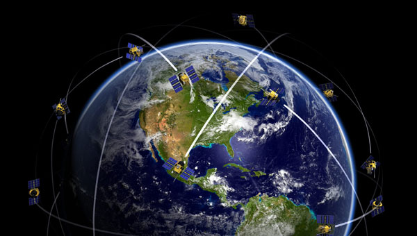
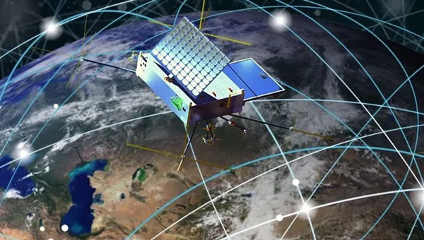
The U.S. Department of Defense (DOD) has unveiled a comprehensive classified strategy for countering unmanned systems. This strategy, signed by Secretary of Defense Lloyd J. Austin III, seeks to address the evolving threats posed by unmanned systems in both current and potential future threats.
Key components of the strategy
This strategy is based on various DOD initiatives, such as the Joint Counter-Small UAS Office, the Warfighter Senior Integration Group, and the Replicator 2 initiative. It also appoints NORTHCOM and INDOPACOM as the lead coordinators for counter-UAS operations, promoting a unified effort in domestic and international airspace.
The strategy identifies five primary objectives:
Improving the detection and characterization of unmanned system threats.
Disrupting and weakening the networks to facilitate the proliferation of unmanned systems.
Defending U.S. interests by incorporating counter-unmanned systems into essential warfighting capabilities.
Providing solutions that enhance speed, adaptability, and scale.
Prioritizing counter-unmanned systems in the design and development of future joint forces.
To achieve these objectives, the DOD plans to launch deliberate campaigns to counter threat networks in partnership with other U.S. departments and agencies, enhance both active and passive defenses, clarify authorities and embed defense measures across military doctrine, training and policy. Additionally, it aims to leverage rapid acquisition approaches and partnerships with industry and allies.
A key component of this strategy is the Replicator 2 initiative, announced in September 2024. This effort focuses specifically on countering small drone threats to critical installations and force concentrations. The Pentagon aims to seek funding for Replicator 2 in the fiscal 2026 budget request, with the goal of fielding improved counter-drone capabilities within 24 months of receiving congressional funding.
The U.S. Court of Federal Claims has allowed Ligado Networks to proceed with its $39 billion lawsuit against the federal government, marking a significant development in a long-standing dispute over 5G spectrum usage and property rights.
Judge Edward Damich partially favored Ligado by acknowledging the company’s case for property interest in the spectrum allegedly used by the Department of Defense (DOD) while rejecting its claim that the FCC license constituted a property right subject to federal taking.
The controversy stems from the FCC’s 2020 decision granting Ligado exclusive authority over spectrum near GPS frequencies, raising concerns about potential interference with GPS systems. Ligado’s October 2023 lawsuit accuses the U.S. government of conducting a “multiyear misinformation and disparagement campaign” to conceal its activities and misappropriate Ligado’s licensed spectrum for DOD systems without permission or compensation.
The government attempted to dismiss the lawsuit in January 2024, arguing lack of jurisdiction and that Ligado couldn’t establish a cognizable property interest in its FCC license. However, Judge Damich’s ruling allows the case to proceed.
At the core of this dispute is the proximity of Ligado’s L-band spectrum to GPS frequencies, raising concerns about potential interference with critical GPS signals used for navigation, timing and various applications essential for national security and economic stability. The DOD, GPS companies and industry officials have strongly opposed Ligado’s plans for a terrestrial 5G network, arguing it could cause harmful interference to GPS receivers.
The U.S. Space Force’s Space Systems Command (SSC) has awarded Raytheon a $196.7 million contract extension for the GPS Next Generation Operational Control System (OCX) program — despite being years behind schedule. This latest award brings the total OCX contract value to nearly $4.5 billion since its inception in 2010. However, according to the U.S. Government Accountability Office (GAO), the total amount is approaching $8 billion.
The OCX program, designed to enhance GPS infrastructure, has faced significant setbacks. It is currently about seven years behind the original schedule, with the GAO reporting that the system of 17 ground stations was not ready by its October 2024 deadline. Further testing is required for the system to be operational by December 2025.
Despite these challenges, OCX remains critical for modernizing GPS capabilities. The system will enable full M-Code capabilities, providing jamming-resistant GPS signals for military operations in contested environments. OCX is also designed to improve cybersecurity for both military and civilian applications significantly. Once operational, OCX will command all modernized and legacy GPS satellites, managing all civil and military navigation signals.
The program has faced scrutiny due to its delays and cost overruns. The GAO has flagged the program’s delays as a risk to the GPS enterprise, while lawmakers have expressed frustration over the delays and budget increases. Despite this, the Space Force continues investing in the program to enhance GPS capabilities for military and civilian users. OCX is expected to provide improved accuracy, availability and resistance to jamming compared to the previous ground control segment. The system will also support the launch and operation of GPS III satellites.
In 2024, we witnessed emerging trends, challenges and opportunities that significantly impacted the GNSS/PNT industry, ranging from advancements in surveying technology to ways to combat the increasing threats of jamming and spoofing. In this year in review, we highlight notable stories from 2024.
This article discussed advancements in bathymetric surveying techniques, highlighting three projects — from SBG Systems, CHC Navigation (CHCNAV) and Advanced Navigation — that are charting underwater environments. It showcased the exploration of the Great Blue Hole in Belize using submarine-mounted sonar, creating a digital twin flood model for China’s Yellow River using unmanned surface vehicles (USVs) and UAVs and the development of an autonomous vessel for surveying wet gaps in military operations.
February
Aligning the trades: GNSS for architecture, engineering and construction
Surveying is an ongoing process on construction sites. Surveyors are the first on the site before any other work begins and the last ones there to map the project “as built.” Total stations with GNSS receivers, tablets and other mobile digital devices are their essential tools, increasingly complemented by UAVs and lidar scanners. In this story on architecture, engineering and construction (AEC), we highlighted three building projects — from ComNav Technology, CHCNAV and Eos Positioning Systems — as well as photos from Juniper Systems.
Photo: Safran Federal Systems
March
2024 GPS World simulator buyers guide
In our 13th annual Simulator Buyers Guide, we featured simulator tools, devices and software from nine prominent companies that aid GNSS receiver manufacturers in product design.
April
L5-first for improved resilience in mass market GNSS
Paul McBurney, co-founder and CEO of oneNav, emphasized the advantages of L5-first GNSS receivers in enhancing resilience against GNSS interference and jamming in mass market applications. He shared how traditional receivers prioritize L1 signals, limiting their effectiveness in high-interference environments, while L5 signals, which have a higher chipping rate and power, can improve jamming resistance by up to 15 dB. The article advocated for the development of L5-first systems to boost GNSS resilience, particularly for critical infrastructure, although challenges such as acquisition complexity and cost must be addressed before widespread adoption.
May
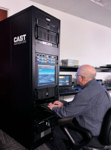
(Photo: CAST Navigation)
Combating jamming and spoofing: PNT on the battlefield
Jamming and spoofing continue to be the key challenges to military use of GNSS. While the production and adoption of M-Code receivers is delayed, defense contractors are developing several approaches to identify, locate and neutralize these threats — including CRPA antennas, embedded GPS inertial (EGI) navigators, software-defined radios and cryptography. In this cover story, executives from seven companies presented their perspectives on the GNSS/PNT challenges faced by U.S. and allied military forces, their market niche in this area and their latest products.
June
NextNav petitions FCC for new spectrum band
NextNav’s petition to the FCC seeks to reconfigure the 902-928 MHz band for a new terrestrial positioning, navigation and timing (TPNT) service. This service aims to complement GPS, enhancing location reliability in urban areas. The integration with 5G technology could further improve positioning services. However, the petition has raised significant concerns within the GNSS industry. Industry leaders argue that granting NextNav access to this spectrum could disrupt existing technologies that rely on the same band. The proposed higher power levels could lead to interference, jeopardizing the operational reliability of various sectors, including supply chains and healthcare. The Federal Communications Commission (FCC) has received more than 1,700 comments highlighting concerns about harmful interference and calling for careful evaluation before any regulatory changes are made. The outcome of this petition could significantly influence the future landscape of positioning technologies in the United States, affecting both GNSS capabilities and the viability of critical applications that depend on current spectrum usage.
July
PNT without GNSS
For the fourth year in a row, the topic for our July cover story was complementary positioning, navigation and timing (PNT). The ongoing challenges of combating jamming and spoofing, as well as enhancing resilience in PNT systems, have been prominent themes in our articles and industry throughout 2024. The U.S. National Space-Based Positioning, Navigation and Timing Advisory Board has been actively working on strategies to “protect, toughen and augment” GPS. The term “augment” refers to enhancements made to GPS and the integration of complementary PNT sources that can partially or fully replace GPS. For this cover story, Editor-in-Chief Matteo Luccio interviewed executives from four companies that design, produce and operate various complementary PNT technologies, highlighting their diverse approaches to this challenge.
Genesis satellite.
August
Innovation: ESA’s Multi-Modal space mission to improve geodetic applications
The European Space Agency (ESA) has established the Genesis mission, a groundbreaking space project that will collocate four space-based geodetic techniques — GNSS, VLBI, SLR and DORIS — on a single satellite for the first time. This mission aims to improve the accuracy and stability of the International Terrestrial Reference Frame (ITRF) to 1 millimeter with long-term stability of 0.1 mm per year, which is crucial for detecting small variations in Earth’s solid, fluid and gaseous components. The Genesis satellite, set to launch in 2028, will orbit at an altitude of about 6,000 km with an inclination of 95° and will operate for at least two years. Members of the Genesis mission team shared how it has the potential to significantly impact various GNSS and Earth observation applications by improving geodetic and geophysical observations, as well as enhancing precise navigation and positioning capabilities.
(Photo courtesy of ION)
September
ION GNSS+ 2024
ION GNSS+ 2024, held Sept. 16-20 at the Hilton Baltimore Inner Harbor, showcased more than 400 technical presentations spanning six sectors. GPS World had the opportunity to engage in a series of discussions and panels, including a plenary session with a presentation on a space project and one on circumnavigating the globe in a sailboat using only paper charts, a compass and a sextant to navigate.
INTERGEO 2024
The GPS World team touched down in Stuttgart, Germany, for INTERGEO 2024, held from Sept. 24-26. This year’s expo and conference showcased solutions to address critical global issues such as GNSS jamming and spoofing. GPS World Publisher Brian Kanaba and Account Manager Tim Carolin made their debut at the show, joining show veteran Editor-in-Chief Matteo Luccio. The show attracted more than 17,000 visitors from 121 countries and featured 579 exhibitors.
October
Lidar helps unlock secrets in Amelia Earhart mystery
The October edition of “Mapping Marvel” focused on research conducted for The Discovery Channel’s documentary, “Finding Amelia.” This film explores the latest expedition aimed at uncovering the mysterious fate of Amelia Earhart. It featured contributions from SPH Engineering and investigated the theory that Earhart and her navigator, Fred Noonan, may have crashed in Papua New Guinea during their 1937 attempt to circumnavigate the globe.
The team utilized lidar technology to conduct low-altitude flights that produced detailed maps of the ground beneath the dense jungle. This approach revealed potential hidden features, including Japanese troop trails and a structure resembling Earhart’s Lockheed Electra.
November
Richard Langley
The last one: A look back at 35 years of ‘Innovation’
The November 2024 issue of GPS World featured Professor Richard Langley’s 300th and final “Innovation” column. His first one appeared in the January/February 1990 issue, the magazine’s very first. In celebration of Richard’s decades-long contribution to GPS / GNSS / PNT, we published a selection of testimonials and photos from some of his colleagues and friends, gathered by his former students Sunil Bisnath and Attila Komjathy.
December
Directions 2024: GNSS constellation updates
This year’s “Directions” feature offers updates on all four GNSS constellations and a regional one. Representatives from each program — BeiDou, GPS, Galileo, GLONASS and QZSS — reflect on the year’s developments, sharing how PNT technologies aim to enhance both defense and civilian applications, ultimately improving navigation capabilities worldwide. The feature highlights significant milestones, including the modernization efforts within each constellation.
AEVEX Aerospace has acquired Veth Research Associates (VRA), a veteran-owned firm specializing in navigation and autonomous systems. The partnership aims to enhance AEVEX’s capabilities in delivering solutions for unmanned systems operating in jammed and contested environments, which is essential for addressing the challenges anticipated in future conflict scenarios.
Established in 2013, VRA brings to AEVEX its intellectual property portfolio centered around a sensor fusion engine, which powers real-time autonomous decision-making using deep neural networks and machine learning. Integrating VRA’s expertise seeks to improve AEVEX’s ability to deliver autonomous hardware and software solutions, particularly combat-proven Group-II and Group III tactical UAS operating in GPS-denied or spoofed environments.
VRA’s LYNX vision-based navigation (VBN) system enables navigation independent of GPS. It features day/night capability, a modular design and open architecture, making it adaptable for use on both manned and unmanned platforms. It is currently deployed with multiple Department of Defense (DOD) and international users.
Brian Raduenz, CEO of AEVEX Aerospace, emphasized the strategic importance of this acquisition, stating, “With the addition of VRA’s leadership team and subject matter experts, we are well-positioned to lead the future of autonomous decision-making in contested environments. Their innovative sensor fusion engine will serve as the backbone of our navigation solutions as we advance into the next generation of GPS-denied capabilities.”
Skykraft, an Australian space technology company, has signed a participating project partner agreement to advance positioning, navigation and timing (PNT) systems in low-Earth orbit (LEO). This agreement, backed by an International Space Investment (ISI) India Projects grant from the Australian Government, marks a significant milestone in fostering space cooperation between Australia and India.
The project’s primary objective is to develop and demonstrate collaborative PNT systems. This includes establishing the viability of large-scale LEO constellations, addressing vulnerabilities in existing GNSS in denied environments, and exploring novel applications for PNT signals from LEO. Additionally, the project aims to create a comprehensive roadmap for collaborative LEO-PNT by implementing resilient, easily updatable constellations.
The project also seeks to enhance environmental monitoring capabilities through GNSS-reflectometry (GNSS-R) and radio occultation (GNSS-RO) technologies. This will improve understanding of Earth’s oceans, droughts, and floods while enhancing real-time space and terrestrial weather forecasting. It will explore emerging applications, such as tsunami monitoring and warning systems.
The automotive navigation of tomorrow is highly connected and capable of dynamically using high-resolution map information and vehicle and environmental data from the cloud. It is an enabler for powerful driver assistance, intelligent e-mobility and autonomous driving. As a global provider of software engineering services for the mobility industry, Intellias is involved in many of these developments.
Although obtaining mapping and navigation data is easier today than it was 10 years ago — thanks to dashcams, UAVs and satellites — collecting this data is still labor-intensive. Even if most corners of the world are already recorded in public and private geographic information systems (GIS), the maps still need to be maintained regularly. Data accuracy and timeliness are the two biggest challenges in the mobility industry, followed by coverage, as the physical world is constantly evolving. To meet these requirements, the evolution of navigation and digital mapping is gathering pace. The following six technology and deployment trends will drive automotive mapping and navigation in the coming years.
1. Enriching Mapping Data With AI
Satellite imagery was a breakthrough for map creation. The wrinkle, however, is that most mapping software cannot work directly with satellite photos. Visual data first needs to be codified into comprehensive navigation datasets in a suitable format such as the Navigation Data Standard (NDS). Then map owners must keep it up to date. Both processes are costly and labor-intensive, making them great use cases for artificial intelligence (AI) in mapping.
AI algorithms improve the speed and precision of digital map building by offering the ability to update maps more regularly and map new areas faster. They can classify objects in satellite images — buildings, roads, vegetation — to create enriched 2D digital maps as well as multi-layer 3D map models. With precise maps, you can delight users with better ETAs, detailed fuel or energy usage estimates, and richer point-of-interest information.
Apart from facilitating the collection of mapping data, AI can also help with generating such data. Researchers from MIT and the Qatar Computing Research Institute (QCRI) recently released RoadTagger. This neural network can automatically predict the road type (residential or highway) and number of lanes even with visual obstructions present, such as a tree or building. The model was tested on occluded roads from digital maps of 20 U.S. cities. It correctly predicted the number of lanes with 77% accuracy and predicted road types with 93% accuracy.
That said, sensor data collection from connected vehicles isn’t going anywhere. OEMs are increasingly relying on their fleets to collect new insights for digital map creation, and this process is becoming easier with advances in machine learning. HERE Technologies recently presented UniMap — a new AI-driven technology for faster sensor data processing and map creation. The new solution can effectively extract map features in 2D and 3D formats, then combine them with earlier map versions. This unified map content data model allows new digital maps to be available in 24 hours.
Photo: Intellias
2. NDS.Live: From offline databases to distributed map data systems
Conventional onboard navigation systems are designed, developed and integrated with proprietary databases, which become obsolete with every new product generation. NDS.Live is the new global standard for map data in the automotive ecosystem, promoting the transition from offline to hybrid/online navigation. It minimizes the complexities of supporting different data models, storage formats, interfaces and protocols with one flexible specification. NDS.Live is not a database, but a distributed map data system.
NDS.Live was co-developed by global OEMs and tech leaders, including Intellias, Daimler, HERE, Denso, Renault and TomTom are among those who have already adopted it. For example, second-generation Mercedes-Benz User Experience (MBUX) systems are powered by NDS.Live. The distributed map data system provides fresh information for the driver assistance system, which gets visualized as augmented reality (AR) instructions on the head-up display (HUD). NDS.Live can help massively improve the navigation experience for EVs and regular connected vehicles. It also helps OEMs deploy value-added subscriptions for assisted driving and navigation.
3. 3D and HD map generation
3D maps enable accurate rendering of physical objects in a three-dimensional form. High-definition (HD) maps feature detailed information about road features (lane placements, road boundaries) and terrain type (severity of curves, gradient of the road surface). Both types of maps are essential for launching advanced ADAS features and, ultimately, ushering in the era of autonomous driving.
3D maps define how the vehicle moves and help it interpret the data it receives from onboard sensors. Since most sensors have a limited range, HD maps assist by providing the navigation system with extra information on road features, terrain and other traffic-relevant objects.
The bottleneck of both HD and 3D mapping is collecting and rendering data. In the case of 3D maps, you need to capture video in real time from multiple cameras, plan for interference due to vibration, temperature and hardware issues, and then repeat the process across billions of kilometers of roads across the globe. Rather than doing this huge task alone, mobility players and OEMs join forces:
• HERE and Mobileye, for example, partnered to crowdsource HD mapping data collection, with VW joining later. Mobileye developed a compact, high-performance computer vision system-on-chip called EyeQ. Installed by more than 50 OEMs across 300 vehicle models, the system supplies Mobileye with ample visual data they can then render into maps with the help of partners.
• TomTom, in turn, teamed up with Qualcomm Technologies to crowdsource HD mapping insights from its users. Qualcomm provides the underlying cloud-based platform for making and maintaining HD maps from various sources, including swarms of connected vehicles.
Photo: Intellias
4. Autonomous driving simulations
Autonomous vehicles require extensive road and track tests to pass security checks. Manufacturers also need to simulate near-crash events without putting anyone in danger. Hyper-realistic virtual worlds can be much safer testbeds for autonomous vehicles (AVs) — especially as virtualization technology improves.
A group of researchers released an open-source, data-driven simulation engine for building photorealistic environments for AV training. The engine can simulate complex sensor types including 2D RGB cameras and 3D lidar, as well as generate dynamic scenarios with several vehicles present. With the new engine, users can simulate complex driving tasks such as overtaking and following.
Waymo takes a similar approach of using real-world data collected from vehicle cameras and sensors to create highly detailed virtual testbeds. The Waymo team has built virtual replicas of several intersections complete with identical dimensions, lanes, curbs and traffic lights. During simulations, Waymo algorithms can be trained to perform the most challenging interactions thousands of times, using the same or different driving conditions and different vehicles from its fleet.
To perfect the performance of the algorithm, the team uses a fuzzing technique. During training sessions, engineers alternate the speed of other vehicles, traffic light timing and the presence or absence of zig-zagging joggers and casual cyclists. Once the Waymo algorithm learns the trick of driving through a specific intersection with a flashing yellow arrow, the “skill” becomes part of the knowledge base, shared with every vehicle across the fleet.
The new generation of high-fidelity 3D environments can be built with data from different sensor types to effectively convey all details of the material world to the algorithm. Existing 3D visual databases already include realistic details for traffic signs, pavement markings and road textures. With machine learning and deep learning algorithms, complex ADAS/AD scenarios can simulate close to real-life conditions.
Photo: Intellias
5. Digital twins of road infrastructure
While OEMs leverage dashcam data collection for building better navigation systems, transportation managers use the same intelligence to digitize road infrastructure. A digital twin is an interactive, virtual representation of physical assets or systems such as a smart traffic light network or smart parking facilities. Powered by real-time data, digital twins of road infrastructure can enable advanced urban planning scenarios. This includes dynamic traffic light signal optimization to reduce congestion as well as prioritized public and service transport management and accurate traffic predictions to optimize planning, signage, construction work schedules, etc.
Low latency is crucial for autonomous driving. Yet 3D map generation on the edge requires substantial computing power. Moreover, vehicles cannot store all mapping data on their route and need to constantly receive over-the-air updates. A group of researchers has proposed placing compact map distribution devices on roadside edges to facilitate point cloud data (PCD) map delivery on the go. The results show that autonomous vehicles can perform self-localization while downloading PCD maps. This system allows autonomous vehicles to receive dynamic new maps for each new destination instead of storing tremendous data records onboard.
6. AR in HUD navigation products
The latest vehicles have an upgraded human-machine interface (HMI)design, featuring new hardware and software elements that allow for AR navigation. AR in HUDs can deliver all standard information from static displays (driving speed, status of the ADAS system, fuel or charge levels), alongside dynamic routing instructions, including information on traffic signs, speed limits, construction work alerts and ETAs.
Overall, AR navigation systems can help drivers make better decisions on the road. A recent comparative study found that drivers using AR-augmented HUDs made fewer errors and drove faster on average than those using conventional HUDs. Participants also rated AR HUD instructions as more useful and easier to understand.
The next advance in navigation will be holographic displays, offering AR instructions in 3D. Advances in lidar technologies already allow for projecting ultra-HD holographic representations of road objects in real time into the driver’s field of view. Such systems can enable shorter obstacle visualization times and reduce driving-related stress, according to Tech Explore.
Brian Thompson, the CEO of UnitedHealthcare, was shot to death on Dec. 4 outside the New York Hilton Midtown in Manhattan, where the company was hosting an investor day. The suspect fled northward on 6th Avenue on a bike toward Central Park and is still unidentified.
Police initially believed the suspect fled on a Citi Bike, which is equipped with GPS tracking devices. However, it was later clarified that the suspect used a regular electric bike, not a Citi Bike, eliminating the possibility of GPS tracking through the bike-sharing system.
Many e-bikes do not come with built-in GPS trackers. While some newer models have integrated GPS units, aftermarket trackers must be installed separately on most e-bikes.
Even if the e-bike had a GPS tracker, its effectiveness would depend on whether it was active and connected to a cellular network to transmit location data.
Despite this setback, investigators are still utilizing various technological methods to track the suspect. Police are analyzing video from street cameras and other sources to trace the suspect’s escape route. Additionally, a cell phone was recovered from the alley where the suspect fled, which could potentially provide valuable information. The suspect was spotted on surveillance video carrying an e-bike battery less than two hours before the shooting, which might offer additional leads.
While GPS tracking through the bike is no longer an option, law enforcement is leveraging other technological resources and traditional investigative methods to locate the suspect.
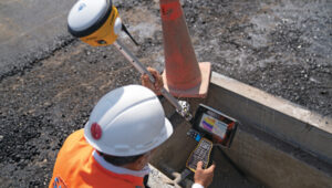
Transportation continues to be a key application area for GNSS and related technologies — both directly, as with receivers on trains, and indirectly, as in airport construction. For this month’s cover story, I chose three transportation-related projects that showcase different aspects of this relationship:
The project to triple the size of the international airport in Lima, Peru, and transform it into the Jorge Chávez Airport City. I posed a few questions to Carlos Ruiz Miranda, chief surveyor at the Lima airport project with SACYR, a Madrid-based global concessions, engineering and infrastructure and services company that specializes in large-scale infrastructure projects.
A train safety project in Vélizy, France. I talked with Joel Korsakissok, president of Syntony GNSS, a French company, which partnered for this project with Hitachi Rail, a global company headquartered in London.
A navigation test on San Francisco’s Market Street using an INS-GNSS integration from ANELLO Photonics, which specializes in silicon photonics and sensory technology. I spoke to Kirstin Schauble, Ph.D., director of systems engineering.
Trimble: Peru builds South America’s first airport city
A construction worker at Lima’s airport uses a Trimble GNSS receiver and a TSC7 controller. Requirements included precisely positioning the bolts for more than 700 seismic isolators. (Photo: Trimble)
On April 3, 2023, the first commercial plane took off from a new 2.2 mile-long runway at the Jorge Chávez International Airport, in Lima, Peru, headed for Tarapoto with 140 passengers. That same day, a Peruvian Air Force jet was the first aircraft to land on the runway. Both aircraft were monitored from a new 213 ft.-high control tower with a 360° view of the airport.
The new infrastructure is part of a larger $2 billion project to triple the size of the airport, turning it into Jorge Chávez Airport City. Additionally, third-party investment for the construction will exceed $400 million in the first phase. The continent’s first such venture, it will enable Peru to become one of its principal aviation hubs. Spanning 2,310 acres, in addition to the new runway and control tower, it includes a 67-acre passenger terminal designed to handle about 40 million passengers a year.
Construction began in January 2022, and the expanded airport is scheduled to open in January 2025. It is a joint project of Lima Airport Partners — which operates more than 30 airports around the world — the Peruvian Ministry of Transportation and Communications, the Peruvian Airports and Commercial Aviation Corporation, and the aviation community in general, under the supervision of Ositran.
The modernization project’s scope and scale are matched by the means and methods used to build it. They include advanced surveying, grade control and coordination techniques in the field and about 2,700 active building information models (BIM) containing more than 50 miles of utilities that multiple contractors will construct. To fully synchronize the digital workflow between the field and the office, Ruiz led the transition from cloud-based collaboration software to a digital workflow. This improved coordination and productivity across departments and helped to keep the project on track.
The transition began by implementing a cloud-based common data environment (CDE), using Trimble Connect to provide a real-time, centralized collaboration platform for the construction crew, the field surveyors and the project’s managers. The CDE became a hub for managing data from field solutions, including laser scanners, UAVs, grade control systems, total stations, GNSS receivers and machine control systems on heavy earthmoving equipment.
A critical part of the terminal expansion is the airside airplane parking area around the terminal, which requires about 70,000 cubic meters of concrete and asphalt. The systems developed by the construction team enable the paving crew to achieve 10 mm accuracy, well below the 18 mm requirements.
Given the number of elements to this project in the terminal and surrounding areas, the SACYR survey team found that one of the best ways to facilitate the data flow between the office and the field is to use augmented reality (AR). “Initially, we tried using paper printouts to manually check for issues in the field. We tried Google Earth, but that was not satisfactory,” said Ruiz. Instead, SACYR turned to Trimble’s SiteVision AR software to provide real-time visualization of data, which improved decision-making and planning and reduced errors and costs.
Nearly 20 Trimble solutions were used in this project (see the sidebar), which helped to synchronize communication between field and office during construction, provided high accuracy results, and improved visualization and collaboration with the customer.
An aerial image shows the new terminal at Lima’s airport under construction. It will be able to handle up to 40 million passengers a year. (Photo: Trimble)
I asked Ruiz a few questions about the GNSS part of the project.
Q: What were the key challenges in surveying for this airport expansion project? Given the nature of the project and its location, multipath was probably not a problem. Also, the new runway and control tower were built away from existing air traffic, so that presumably was not a problem either.
A: The challenge has been organizing workflows between the field and the office. The location was not an issue for the project, but the limited space between the existing runway and the new one was. Nevertheless, it was not really an issue for construction.
Q: The airport will be the first one in South America to have seismic isolators to allow it to serve humanitarian flights following an earthquake. Did that pose any special challenges for surveyors?
A: Yes, it was a challenge for surveyors because there are more than 700 seismic isolators, and they each have anchor bolts that have precise tolerances to be embedded in the concrete. For this they used Trimble total stations.
Q: Did this project have any special requirements?
A: Special requirements were the precision of the seismic isolators, the precision of the plumbness of the columns and beams, and the precision of the leveling of the concrete of the parking spaces and the asphalt for the aircraft.
Q: What total stations were used?
A: A S5 1 second with TDC600, software access, a UHF 35Watt GPS data radio, and different GNSS receiver models for the project.
Q: The airport expansion is part of Lima’s new airport city. How was surveying for the former tied into the latter?
A: The benchmark control points certified by the Peruvian IGN will be left in place and become part of the LAP airport geodetic network.
Autonomous railway track detection
Redundant ssm receiver installation inside a test train in France. (Photo: Hitachi Rail and Syntony GNSS)
Around the world, efforts are underway to increase the safety of rail transportation — both for passengers and for communities along rail lines that are vulnerable to derailments that can lead to spills of harmful chemicals. The most notable recent example of the latter in the United States was the derailment of 38 cars of a freight train in East Palestine, Ohio, in February 2023, which forced the evacuation of a 1-mile radius around the spill.
Hitachi Rail and Syntony GNSS are collaborating on a train safety project in Vélizy, France. Members of the Hitachi Rail team wrote a paper1 on the project that they presented at the Institute of Navigation’s GNSS+ 2024 conference in Baltimore in September 2024. “Everybody is now trying to locate trains with the highest possible Safety Integrity Level (SIL), which is SIL 4,” said Korsakissok, discussing the project. “The partnership between Hitachi Rail and Syntony aims to reach this level by the end of 2025.”
Many modern automatic train operation (ATO) systems — an advanced technology that enables trains to run automatically without the need for a human driver — provide real-time information to the train about its location, speed and other important operational parameters. They use small radio beacons placed along the railway track, typically every third of a mile to half a mile, and an onboard antenna to collect the data. The problem with this positioning system is that it has high installation and maintenance costs. Therefore, the use of GNSS is seen as a major step toward train autonomy. However, due to local disturbances (masking and multipath), classical GNSS positioning methods can be inaccurate by up to many meters, which does not meet railway safety requirements.
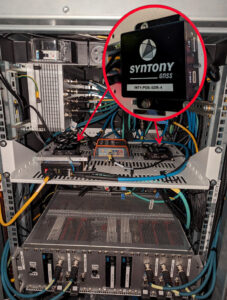
The Hitachi Rail safety project in Vélizy is part of a global next-generation train positioning architecture. It supplements a stand-alone GNSS positioning solution with a satellite signal map matching technique and derived integrity methods. It uses cold start for track detection and requires neither motion nor a priori knowledge of the train’s position. The GNSS receiver used in this project is from Syntony GNSS.
A satellite signal map matching (SSM) algorithm developed for this project, in combination with accurate maps, computes the correlation between the received GNSS signal and a predicted PRN code for a chosen satellite, chosen epochs and a known georeferenced point from the map. In the absence of any errors, the user’s antenna would be expected to be located at the georeferenced point. However, this matching is never perfect, so the technique evaluates its quality based on its degree of correlation and the observed delays. It then uses several consolidation methods that take advantage of the whole set of available satellites.
“This approach is well suited to the track detection case of railway navigation when no previous knowledge of the position is given (at train cold start), as the algorithm is detecting a known position, while most of the current GNSS algorithms are estimating a position,” write the authors of the ION paper on the project, who are all members of the Hitachi Rail innovation team in Vélizy.
“The receiver embedded in the train is based on Syntony’s ORION receiver platform,” Korsakissok said. “ORION is a hardware platform that includes a system-on-chip (SoC) from Xilinx, inside which we put a GNSS software-defined radio (SDR) receiver that tracks the GPS L1/L5 and Galileo E1/E5a signals.” For Hitachi, Korsakissok continued, Syntony added a “map matching” feature to the receiver, “which is done in an original (and patented) way: All along the rail tracks, we define some ‘points of interest’ (POI) and the objective of the SSM algorithm is to detect the probability of going over one POI at a given time. Obviously, if there is only one track, and if the train goes from one station to the next, we know that it will pass over this POI, and the only question is when. Inversely, if there are two or more tracks, the most important question is on which track the train is, to avoid any collision. In this case, we define a set of POI on each track, and the key is for our SSM algorithm to tell us which one the train passed.”
The autonomous location software (ALS) used for this project runs on an industrial-grade computer approved for railway usage. Running tests are done in a lab with an antenna located both on the roof of the team’s building in Vélizy and on the train. A grid map from true line tracks is used in both cases.
“To our knowledge,” Korsakissok explained, “almost all train operators that are locating trains with GNSS for positive train control (PTC) or for the European Rail Traffic Management System (ERTMS) are solving this problem by measuring the distance between the position computed by the receiver and all present tracks, then choosing the lower one as the most probable. This can work well if the train is moving and if a hybridization algorithm is used with an inertial navigation system (INS) and odometry. However, it does not solve the so-called ‘cold start’ problem — which is that you cannot use the train’s last known position as the new starting point because it could have been moved without powering up its electronics. The SSM algorithm solves this issue, because it directly correlates each satellite signal that should be received if the receiver were exactly at the position of the targeted POI. This correlation algorithm will have a very strong peak as soon as the antenna is near the correct position. This method has been simulated and tested on real tracks and has shown very good and significant results.”
Once the project achieves SIL 4 — a milestone scheduled for late 2025 — Hitachi Rail will embed the receiver designed and manufactured by Syntony GNSS in its future lines and trains.
Inertial-assisted navigation in an urban canyon
San Francisco’s market street, like all urban canyons, is a very challenging environment for satellite navigation. (Photo: Spondylolithesis / iStock / Getty Images Plus / Getty Images)
Urban canyons — city streets lined with tall buildings on both sides — present two challenges to GNSS: a limited view of the sky, thus a reduced number of satellites in view and a higher positional dilution of precision (PDOP) than under open sky, and multipath, as signals bounce off the vertical faces of the buildings before reaching receivers on the ground. This greatly complicates the tasks of accurate positioning and navigation — which is especially important for vehicles in congested city traffic, where it is essential that they do not stray from their lane.
Hundreds of research papers on possible solutions to the challenge of urban canyons have been presented at satellite navigation conferences over the years. One standard way to compensate for both a reduced number of satellites in view and multipath is to couple a GNSS receiver with an INS. GNSS and INS are inherently complementary technologies.
An INS consists essentially of an inertial measurement unit (IMU) and a computer. An IMU measures an object’s linear acceleration (typically, with three orthogonally mounted accelerometers) and angular velocity (typically, with three orthogonally mounted gyroscopes) in three axes. Because an IMU requires no external inputs, it can operate in tunnels, inside buildings and underwater, and is unaffected by such vagaries of the radiofrequency environment as jamming and spoofing. An INS integrates IMU data to compute positions that are very stable epoch to epoch. However, all inertial systems accumulate measurement errors, an effect known as drift, and therefore must be periodically re-initialized.
Conversely, GNSS-based navigation systems offer consistent absolute positioning accuracy, but their performance is severely degraded by a restricted view of the sky and multipath, two conditions characteristic of urban canyons, as well as RF interference (jamming and spoofing) and ionospheric disturbances.
Therefore, GNSS and INS, when coupled, assist each other beautifully: The INS takes over when the performance of the GNSS receiver is degraded or entirely impeded, then the latter re-initializes the former once it returns to full operation.
An INS provides another benefit for vehicle navigation. In addition to providing data about a vehicle’s trajectory, it also measures its attitude (roll, pitch and yaw), thereby enabling the software to better correlate and interpret the data from the other sensors. For example, when a car breaks sharply, its front end goes down and any forward-facing sensors measure distances to points closer to the car than they did a moment earlier, when its chassis was parallel to the street surface. An INS can also detect unsafe conditions, such as excessive slip angle, which is the angle between the direction of the rolling wheels and that in which the vehicle is pointing (true heading). A slip angle as small as 0.5° can trigger skidding, spins or rollover, especially in the case of SUVs and tall trucks.
A recent test in one famous urban canyon proved once again the value of GNSS-INS integration.
Market Street in San Francisco is one of the major routes across the city, with a diverse urban landscape. It poses numerous challenges in effectively navigating vehicles, especially autonomous ones, due to narrow streets with skyscrapers, resulting in limited sky view and severe multipath. ANELLO tested its GNSS INS here and evaluated the system’s performance in real-world driving conditions compared to other established inertial navigation systems solutions on the market.
Anello’s GNSS INS remains accurate despite multipath and a limited view of the sky. (Photo: ANELLO Photonics)
Market Street is a 3.5-mile urban artery that winds through diverse neighborhoods and commercial zones, presenting a formidable challenge for vehicle navigation as much due to its bustling traffic as for its towering urban canyons. The ANELLO GNSS INS addresses this complex environment by integrating data from its optical gyroscope with those from a GNSS receiver and wheel speed odometers using its sensor fusion engine and unique optical gyroscope technology. In addition to autonomous vehicles, it is also a good solution for agriculture, robotics, construction, trucking, mapping/surveying and defense applications.
To evaluate the performance of its GNSS INS, ANELLO installed it on a test vehicle together with a comparable system made by a different company. The ANELLO team then conducted multiple drives along Market Street, focusing its assessment on the system’s overall heading and positional accuracy. According to ANELLO, the system maintained a close alignment with the vehicle’s actual position along the entire route with a drift of about 1 m on multiple occasions, “significantly outperforming its competitor’s drift rates of 15.5 m, over a drive length of 250 m.”
“The interplay between GNSS and INS is like a tightly choreographed dance,” said Schauble, “where the choreographer is a sensor fusion algorithm. This algorithm continuously evaluates the quality of the GNSS and IMU measurements, assigning weights to each based on their reliability and accuracy.”
The accuracy of an INS is inherently dependent on the quality of its IMU. “When an INS system containing a MEMS IMU is used in an urban canyon, the algorithm is forced to either lean more heavily on the degraded GNSS measurements or accept the noisy and biased IMU measurements,” Schauble pointed out. “This often results in a poor and unpredictable solution in such environments. On the other hand, ANELLO’s GNSS INS leverages a silicon photonics optical gyroscope (SiPhOG) that provides significantly better bias and noise compared to MEMS IMUs. This makes the algorithms less vulnerable to degraded GNSS and multipath effects, allowing the INS solution to maintain accurate positioning in an urban canyon.”
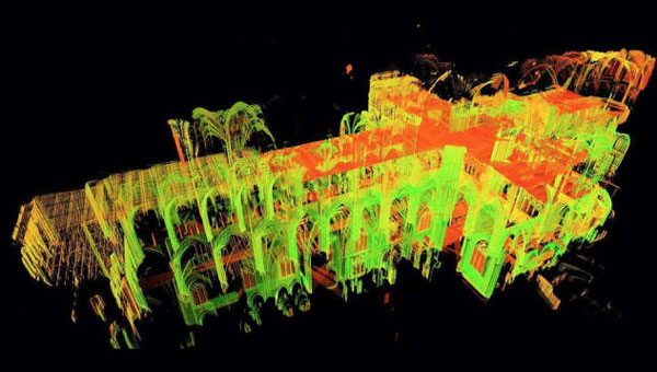
3D model of the Notre Dame Cathedral. (Image: Andrew Tallon/Vassar College)
Notre Dame Cathedral in Paris has reopened its doors five years after the devastating fire, showcasing its restored interior after extensive rebuilding work. The restoration, costing approximately €700 million ($737 million), was financed entirely by donations from around the world.
On April 15, 2019, Notre Dame went up in flames, with the spire collapsing and the roof being destroyed. The following years were dedicated to rebuilding the cathedral, including the reconstruction of the spire and the restoration of stained glass and woodwork.
A crucial element in the restoration process was the point cloud data collected by professor Andrew Tallon, an architectural historian from Vassar College, in 2010. Tallon’s project, which aimed to fully understand the Gothic structure and identify structural anomalies, involved creating a precise 3D model of Notre Dame using a Leica Geosystems terrestrial laser scanner.
This cloud of 1 billion points proved indispensable for the digital recreation of the cathedral’s interior and exterior. Tallon’s laser scans were the only truly accurate as-built measurements of Notre Dame, translating point clouds into detailed representations of its buttresses, ribbed vaults, stained glass, ornate carvings and other architectural details.
The value of point cloud data
While modern restoration efforts cannot fully replicate the artistry of centuries past, Tallon’s scans have been instrumental in reconstructing the Gothic cathedral, allowing architects to come remarkably close. Although Tallon died in 2018, his groundbreaking work remained a vital resource for restoring the iconic cathedral.
A point-cloud scan taken from Andrew Tallon’s scans of the Notre Dame Cathedral. (Photo: courtesy of Vassar University)
Tallon’s meticulous 3D scans of Notre Dame provided architects with information crucial for the cathedral’s reconstruction, including:
Precise 3D models: Tallon’s precise 3D model of Notre Dame included intricate details of the cathedral’s architecture, such as flying buttresses, rib vaults, stained glass windows and ornate carvings. This level of detail was unmatched by any historical drawings or records, which often lacked precision.
Dimensional and formal reconstruction: Pascal Prunet, one of the architects tasked with rebuilding the cathedral, said in an interview with Lindsay S. Cook that the point cloud data provided an “exact trace” of the cathedral’s state at the time of scanning, allowing him and his team to reconstruct elements — such as the vaults — “without hesitation” regarding dimensions or forms. This was essential for accurately rebuilding complex structures such as flying buttresses and rib vaults.
Structural analysis: The scans revealed structural details that were previously unknown, aiding in understanding how the cathedral was originally constructed and how it changed over time. This information was vital for designing custom supports and ensuring structural stability during reconstruction.
Integration with modern technology: The point cloud data was integrated into Building Information Modeling (BIM) processes, which allowed architects to create a digital twin of Notre Dame.
Restoration guidance: The scans provided a highly detailed record of Notre Dame’s pre-fire condition, which helped restoration professionals select appropriate techniques for stabilizing and rebuilding various parts of the cathedral.
Why precision matters
The two architects highlighted the crucial role Tallon’s laser scan of the cathedral played in their restoration process. They shared how this detailed digital model provided them with precise measurements and structural information, enabling Notre Dame to, in essence, “guide its own restoration.” By relying on this accurate data, the team could ensure its work remained faithful to the iconic cathedral’s original design and construction.
Tallon’s laser scan of Notre Dame Cathedral has proven invaluable in the restoration process. This digital twin, created in 2015, offers an unparalleled level of precision and detail, capturing the cathedral’s every nuance with accuracy up to 5 mm. This level of detail allows the restoration team to address the structure’s complexities and make informed decisions about the rebuilding process, ultimately helping to preserve Notre Dame’s authenticity and historical integrity.
The development and digital transformation of the global economy are based today on high-precision time synchronization of transport management processes, the transmission of electricity and data and many other processes. The high-precision global synchronization of GNSS spacecraft signals makes global instantaneous all-weather navigation possible and is the primary solution to the problem of time transmission.
For the past 57 years, since their adoption by the International Bureau of Weights and Measures (BIPM) as a unit of time measurement in the International System of Units of the Atomic Second, the technical characteristics of atomic frequency standards have increased significantly. The universally used Coordinated Universal Time (UTC) is based on the atomic time scale (AT), the readings of which are adjusted taking into account data regarding the Earth’s rotation.
Since its inception, GLONASS has relied on basic solutions embedded in the definition of UTC(SU). AT is formed by calculating the total number of vibrations at the resonant frequency of the energy transition between the levels of the hyperfine structure of the ground state of the cesium atom (133Cs) in the absence of external influences. It was based on this substance that the first ground and airborne frequency standards for GLONASS were created.
In accordance with the system’s interface control document, GLONASS transmits Moscow Time1, which is established by law by the Russian Federation. GLONASS transmits UTC(SU), which is formed as UTC+3 hours. In recent years, much work has been done to modernize the infrastructure for the formation of the national UTC(SU) time scale2. Today, the State Standard of Time and Frequency (SSTF) of the Russian Federation is one of the most modern time synchronization centers in the world. The basis of the SSTF are hydrogen frequency and time standards (HS) of the active type. The composition of the SSTF includes a storage complex of the national time scale based on the six newest active-type HS with a daily frequency instability of 3×10-16. In total, the SSTF consists of 18 HS.
Including new HSs in the composition of the SSTF has led to a significant increase in its contribution to forming the UTC scale. Currently, 87 time standards at national time laboratories contribute to the formation of UTC, which, following the recommendations of the BIPM time department, regularly provides measurement information of standards of the established format and content. In turn, the BIPM time division forms the International Atomic Time Scale (TAI) and the UTC scale. On a monthly basis, the BIPM Time Department publishes the results of the international key comparisons CCTF-K001.UTC and other data based on which a comparative analysis of the metrological characteristics of national standards is carried out.
The ALGOS algorithm is used for the formation of TAI and UTC2. It includes two main procedures: forecasting the drift of the frequency of standards and determining the contribution of specific standards to the final result — determining the statistical weight of standards.
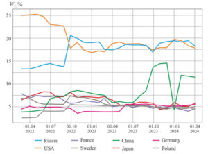
Figure 1: Dynamics of the contribution of the world’s major time laboratories. (All figures provided by the authors)
Starting in September 2011, forecasting of the standards’ frequencies takes into account the frequency drift inherent in hydrogen frequency standards. The procedure for determining the statistical weight of standards was also changed; preference was given to the predictability of their frequency, which showed a more balanced distribution of statistical weights and increased the contribution of hydrogen standards to the formation of TAI and UTC.
Figure 1 shows the dynamics of the contribution of the world’s main time laboratories to the formation of UTC for 2022-2024: Russia – the Main Metrological Center of the SSFT, SU; United States – Naval Observatory, USNO; China – National Time Service, NTSC; Japan – National Institute of Information and Communication, NICT; France – Paris Observatory, OP; Sweden – Technical Research Institute, SP; Germany – Institute of Physics and Technology, PTB; Poland – Time Laboratory, PL. The WT contribution of each laboratory is calculated as the sum of the weights of all frequency standards, the measurement results of which this laboratory transmits to the BIPM. The weight of each individual atomic time and frequency standard is calculated monthly by the BIPM time division when calculating TAI and UTC based on an assessment of its frequency stability over the billing period.
The main characteristic of the HS, which affects the characteristics of the formation of time scales, is the instability of the frequency of the output signals. To quantify the frequency instability of the output signals, a number of characteristics are used that reflect both random and systematic frequency changes over time. The Allan variation has been widely used for more than 50 years as the main assessment of the frequency instability of the output signals of standards in the time domain.
At the same time, in terms of frequency instability, the SSTF atomic clock also occupies a leading position. In October 2022, the average weight of atomic clocks of laboratories in the formation of TAI and UTC increased significantly, from 1 to 1.2% to 1.4 to 1.6% (the best indicator for foreign laboratories is 0.5 to 0.7%). This indicator is calculated by dividing the total contribution of each laboratory by the number of its atomic clocks that participated in the formation of TAI and UTC in the period under review. The average contribution more correctly characterizes the quality of the frequency standards of each time laboratory.
Additionally, an important indicator is the percentage of atomic laboratory clocks having the maximum allowable BIPM weight for an individual frequency standard. For 2022-2024, the figure ranged from 80% to 100%. The maximum possible weight depends on the total number of frequency standards involved in the formation of UTC in a particular billing period. This indicator was calculated as the number of atomic clocks having the maximum permissible weight divided by the total number of hours of this laboratory in each calculation period. All HSs from the SSFT have the highest rates of frequency instability and for most of the period under review make the maximum possible contribution to the formation of TAI and UTC.
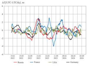
Figure 2: Comparative estimates of national time scale shifts. (All figures provided by the authors)
The characteristics of the Russian HS directly impact the formation of the national atomic and coordinated time scales of the Russian Federation TA(SU) and UTC(SU). Figure 2 shows the differences between national time scales and UTC.
Coordinated Universal Time(k) relative to UTC in 2022-2024.
The analysis of this data allows us to conclude that the UTC(SU) national coordinated time scale is one of the best national implementations of UTC, and the national atomic time scale TA(SU) occupies a leading position in terms of instability among the scales implemented in the leading national time laboratories.
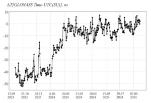
GLONASS’ time scale is linked to the readings of the SSTF, taking into account the correction of the Moscow decree time and are implemented by the GLONASS synchronization system, which is also based on hydrogen frequency standards. Figure 3 shows the discrepancy between the values of the GLONASS system time relative to the UTC(SU) time, which is currently less than 10 ns.
Figure 3: Error in transmitting the national time scale of the Russian Federation UTC(SU) using GLONASS. (All figures provided by the authors)
UTC(SU) parameters are transmitted via GLONASS spacecraft and the first of the fourth-generation spacecraft, which has a passive hydrogen maser (PHM) on board, was launched into operational orbit on Aug. 7, 2023. In the spring of this year, flight tests of this device began, which showed an improvement in the accuracy of time transmission during the transition from the cesium to the hydrogen standard.
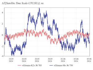
Figure 4: The discrepancy between the spacecraft time scale and the UTC scale: 1 – Glonass-K2, orbit slot 26, 2 – Glonass-M, orbit slot 12. (All figures provided by the authors)
Figure 4 shows the magnitude of the discrepancy between the time scales of the two GLONASS spacecraft. The cesium frequency standard installed on board the Glonass-M shows some of the best characteristics in the entire 20-year history of these spacecraft and demonstrates a daily relative frequency instability of 2×10-14, which is five times better than the design characteristics. Preliminary results of the use of the PHM as a source of reference vibrations and time synchronization pulses on board the Glonass-K2 in the same time interval shows a decrease of more than two times in the fluctuation error of forecasting the time scale with a relative daily instability of 7 × 10-15.
Similar characteristics emerge when using the most conservative spacecraft control scenario. Here, the update of the on-board clocks parameters (OCP) of the on-board time scale departure model relative to the system is carried out once per turn, i.e. once every 11 hours and 45 minutes. This ensures a decrease in the value of the OCP contribution to the error of navigation definitions due to the space complex before updating them from 1.4 m with a daily instability of 1×10-13 to 0.1 m for a relative daily instability of 7×10-15. The results obtained make it possible to redefine the basic onboard standard and switch to the priority use of the HPM signal for the formation of reference oscillations and clock synchronization of GLONASS spacecraft signals.
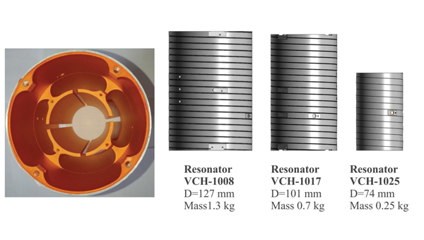
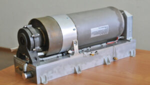
Figure 5 Passive hydrogen maser VC-1017. (All figures provided by the authors)
Further development of this technology provides for installing a VC-1017 small frequency standard on board (Figure 5). Compared with the one presented in a previous article, this standard is more than two times lighter while maintaining the stability characteristics of the formation of reference vibrations (Figure 6).
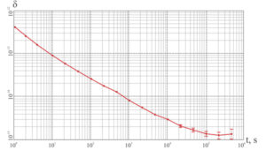
Figure 6 Measured instability of the VCH-1017 frequency relative to the state primary standard of time units, frequency and Russia’s national time scale for 40 days. The frequency drift was 1.51×10⁻¹⁵. The daily instability with the exception of drift is 1.42×1. (All figures provided by the authors)
The launch of the Glonass-K2 spacecraft with the prototype of this HPM is planned for the first half of 2025. Its precision characteristics allow us to expect a further increase in the stability of time transmission by GLONASS.
A significant improvement in the metrological characteristics of hydrogen frequency standards is achieved using a new system for forming a beam of atoms in a single energy state, which was developed before their industrial use. Thus, the daily frequency instability in active hydrogen frequency standards using a new beam formation system reached the level of (6-8) ×10-17.
Figure 7: Microwave resonators for passive hydrogen frequency standards. (All figures provided by the authors)
The basis for creating passive frequency standards of various sizes was the pioneering invention of an oscillatory structure, which is used in all passive hydrogen frequency standards for global navigation satellite systems. This microwave resonator made it possible to change the dimensions at a constant resonant frequency of 1,420,405,751 Hz, close to the frequency of the atomic transition. At the same time, the design proved to be suitable for harsh operating conditions, including requirements for the launch of the spacecraft. (Figures 7 and 8).
Figure 8: Microwave resonators of different sizes for passive hydrogen frequency standards. (All figures provided by the authors)
Reducing the size of the “heart” of the frequency standard allows you to reduce the weight of all other structural elements — thermostats, magnetic screens, vacuum caps, supports, etc. At the same time, it is easier to achieve structural rigidity requirements and reduce the influence of destabilizing factors.
The most important factor influencing the metrological characteristics of passive hydrogen frequency standards is the automatic frequency tuning system of the quartz oscillator to the frequency of the spectral line.
Careful engineering of the auto-tuning system avoids the influence of control circuits on each other. In addition, a technical solution has been introduced in the new frequency standards of the GLONASS system, which makes it possible to reduce the impact of various factors on the stability of the output frequency.
The results obtained allow us to consider the coming year 2025 as an important milestone in the development of time transmission technologies through the GLONASS system.
YellowScan and Argosdyne have partnered to integrate YellowScan’s Surveyor Ultra OEM lidar system with Argosdyne’s newly C2 Class certified AQUILA-2 UAV. This collaboration aims to improve data acquisition and drone performance for various industries.
The C2 Class certification allows for safer operations near people and in urban areas, meeting European safety standards. Combined with YellowScan’s lidar technology, this certification allows for more precise and efficient data collection for surveying, mapping and environmental monitoring projects.
The integrated system captures detailed point cloud data and high-resolution imaging, providing comprehensive views of topography, structures, and vegetation. This technology can be applied in urban planning, construction, infrastructure inspection, and environmental science. Argosdyne’s AQUILA-2 UAV was showcased at INTERGEO 2024.