Blog

  • Hemisphere GNSS Offers New Survey-Grade GNSS Antennas

    Hemisphere GNSS Offers New Survey-Grade GNSS Antennas

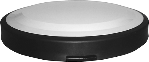
    The A25 and A45 antenna. Photo: Hemisphere GNSS
    The A25 and A45 antennas. Photo: Hemisphere GNSS

    Hemisphere GNSS has announced two low profile, multipurpose antennas that it says will exceed expectations in all GNSS applications. With unique filtering patterns and precise attention paid to mitigation of multipath and interference, the A25 and A45 antennas complement all GNSS products, from L1 GPS to multi-frequency, multi-constellation.

    Both antennas are being featured at the InterGeo 2014 Conference and Trade Show in Berlin this week, at stand C2.007.

    The A25 and A45 have been designed to support millimeter accuracy for land and marine applications. Both antennas support present and future GNSS signals, including GPS, GLONASS, BeiDou, QZSS, and Galileo. The A25 supports the previously mentioned signals at a single-frequency level, while the A45 supports these signals at a multi-frequency level.

    “We’ve designed these antennas to excel in challenging environments such as near buildings or under foliage,” said Lyle Geck, senior manager of product marketing at Hemisphere GNSS. “They have superior multipath mitigation, stable phase centers and strong SNR’s, even at low elevations.”

    The ruggedized housing used by both antennas is made of an aluminum base that has been pretreated for the marine environment and will withstand salt, fog, and spray. The antennas pass the two-meter pole drop test.

    The A25 is a multi-GNSS precision antenna, designed for a variety of applications including GIS, single-frequency RTK positioning and navigation, and precision guidance. The A45 is a survey-grade, multi-GNSS precision antenna for a variety of applications including surveying, RTK positioning and navigation, precision guidance, and machine control.

    For more information about Hemisphere GNSS’ antennas and other products, please visit www.hgnss.com/Products-Solutions.


  • Applanix Offers Single-Board GNSS-Inertial System for UAV Mapping

    apx-15-in-hand
    Photo: Applanix

    Applanix, a mobile mapping and positioning company, has introduced a new product that enables major improvements in unmanned airborne mapping: the Applanix APX-15 UAV GNSS-Inertial System. The announcement was made at InterGeo, being held this week in Berlin.

    The APX-15 UAV is designed to maximize the efficiency of mapping from small unmanned aerial vehicles (UAVs) by reducing — or even eliminating — Ground Control Points (GCPs). Sidelap is also significantly reduced, increasing the area flown per mission. The Applanix APX-15 UAV provides performance in a small package and, with the included POSPac UAV post-mission software, produces a highly accurate position and orientation solution for direct georeferencing of cameras, LIDARs and other UAS sensors, the company said.

    “Applanix has recognized the need to provide the growing UAS mapping market with the same highly efficient solutions that it pioneered for airborne mapping over 15 years ago,” said Joe Hutton, Director of Inertial Technology and Airborne Products at Applanix Corporation. “We are offering a cost-effective solution that meets the size, weight, power and cost requirements of small UAS, and maintains the Applanix pedigree for quality and performance.”

    The APX-15 UAV, measuring just 6 cm x 6.7 cm and weighing only 60 grams, features a high-performance, survey-grade, multi-frequency GNSS receiver and low-noise MEMS inertial sensors all on a single board. The Applanix IN-Fusion GNSS-Inertial integration technology runs directly on the GNSS receiver, resulting in an ultra-compact design, while superior performance is achieved from the inertial sensors using the Applanix SmartCal software compensation technology.

    With 220 channels, the APX-15 UAV tracks all available GNSS satellite signals including GPS L1/L2/L2C/L5 and GLONASS L1/L2, QZSS, BeiDou and Galileo, and provides a highly accurate post-mission and real-time RTK GNSS-inertial position and orientation solution to support guidance and control, precision landing and sensor geo-referencing.

    APX-15 UAV is expected to be available worldwide in the first quarter of 2015 through the Applanix sales channel.

  • NGA Issues Advisory Notice on Web Mercator for Mission-Critical Operations

    The National Geospatial-Intelligence Agency (NGA) has issued an advisory notice on the use of Web Mercator for mission-critical operations.

    The notice outlines application risks to operations and adherence to Department of Defense World Geodetic System 1984 (WGS 84).

    “This message outlines the risks associated with the use of Web Mercator applications for DoD and GEOINT user community operations. The NGA Geomatics Office has assessed the use of Web Mercator and other non-WGS 84 spatial reference systems may cause geo-location / geo-coordinate errors up to 40,000 meters. This erroneous geospatial positioning information poses an unacceptable risk to global safety of navigation activities, and Department of Defense, intelligence community, and allied partner systems, missions, and operations that require accurate and precise positioning and navigation information. The NGA Geomatics Office reminds the community to use DoD approved World Geodetic System 1984 (WGS 84) applications for all mission critical activities.”

    Many popular commercial visualization, mapping and mobile web device applications use a Web Mercator spherical earth reference. “These applications are not an equal alternative to DoD WGS 84, as they do not provide the same geo-coordinates or geo-location accuracies,” the advisory states.


  • World Space Week Focuses on Satellite Navigation


    The United Nations is spotlighting the benefits of satellite navigation and its contribution to the betterment of humankind as part of the observance of World Space Week — an annual global celebration of the contributions of space science and technology to humanity.

    The theme of this year’s World Space Week is Space: Guiding Your Way. It highlights the benefits of satellite navigation to society, which Simonetta Di Pippo, director of the UN Office for Outer Space Affairs (UNOOSA), said are of “great importance” to her office. UNOOSA also functions as the Executive Secretariat to the International Committee on Global Navigation Satellite Systems (ICG), which promotes voluntary cooperation on civil satellite-based positioning navigation, timing and value-added services.

    Proclaimed by the UN General Assembly in 1999, World Space Week, observed each year during the week of October 4-10, aims to provide unique leverage in space outreach and education; educate people around the world about the benefits that they receive from space; encourage greater use of space for sustainable economic development; demonstrate public support for space programs; excite young people about science, technology, engineering, and math; and foster international cooperation in space outreach and education.

    The dates recall the launch on October 4, 1957, of the first artificial satellite, Sputnik I, and the entry into force, on October 10, 1967, of the Treaty on Principles Governing the Activities of States in the Exploration and Use of Outer Space including the Moon and Other Celestial Bodies.

    Ideas for educators and youth groups to focus on satellite navigation include geocaching, building model satellites, and using Google Earth. “Imagine a world without navigation satellites to guide planes, ships and cars and not to forget: us with our location-based mobile phone applications!” the guide states. “And navigation satellites not just accurately pinpoint our position on the planet, it also provides time signals to keep clocks in sync, which is critically important for global trading and many other time critical sectors. In times of disaster navigation satellites help rescuers quickly find spots where people need help. Using Geographic Information Systems (GIS) we can compare maps before and after things changed. And GNSS satellites are important to help you planning your trips and tell you where it will rain and where it will shine!”

  • Improper Fuel Line Installation Led to Incorrect Galileo Orbit

    The cause of two Galileo satellites being released into the wrong orbit August 22 can be traced to improper installation of a hydrazine fuel line, according to Space News and the GalileoGNSS blog.

    The hydrazine fuel line was installed too close to a supercold helium line on the Fregat upper stage, which caused the hydrazine to freeze long enough to upset the Fregat stage’s orientation and cause the two satellites’ release into an orbit that is both too low and in the wrong inclination, officials said as reported on the websites.

    No official report has been issued; the board of inquiry is expected to release its findings this week. 

    The Euro-Russian inquiry board looking into the cause of the failure has discovered that one in four Fregat upper stages at prime contractor NPO Lavochkin in Moscow had the same fuel-line installation, according to the reports. “We have to assume that this was a practice that had gone on in perhaps a quarter of the Fregat stages produced in the past decade, but that it had not affected our launches up to now because of mission-specific aspects like coast time between burns, the number of burns and so on, which can influence the effect of the helium on the hydrazine,” one official is quoted as saying. “In any case, we’d like Arianespace, which currently has almost no inspection rights on the Soyuz, to be given more say in quality assurance.”

    In the stages without the installation issue, the hydrazine and helium lines were separated so that the supercold helium could not freeze the hydrazine. The design did not foresee any problem in putting the lines together, but in fact that is a problem for some missions.

    European Union government and officials are debating how to proceed, the reports said. The options are to continue, as scheduled, with the December launch of two more Galileo satellites aboard a Soyuz Fregat rocket, or to wait until next spring or summer and launch four Galileo satellites on a heavy-lift Ariane 5 vehicle.

    As for the two wayward satellites, in a presentation to the 65th International Astronautical Congress in Toronto September 30, OHB’s Galileo deputy program manager, Kristian Pauly, said he was optimistic that once the satellites’ perigee is raised and their orbit made less eccentric, they can be fitted at least partially into the Galileo program and perform a navigation function, Space News reported. OHB System is the prime contractor for the full operational capability (FOC) satellites.

    The first priority, Pauly said, is to take the two satellites out of regular contact with the Van Allen belts and adjust their Earth sensors to their new, unplanned view of Earth — which is much closer given the lower altitude.

    Pauly did not speculate on what the Galileo launch schedule would be. He said that OHB’s delivery schedule will not change much. “We have a delivery schedule that is extremely challenging and we will keep to it,” he said.

  • Live from InterGeo

    Geospatial Solutions/GPS World staff will be reporting from InterGeo October 7-9. The massive trade show, held this year in Berlin, is considered the world’s leading conference trade fair for geodesy, geoinformation and land management. With more than 16,000 visitors from 80 countries, it is one of the key platforms for industry dialogue.

    Staff members attending include GPS World Editor and Publisher Alan Cameron, Survey/GIS Editor Eric Gakstatter, and Digital Editor Joelle Harms. All three are accepting meeting invitations for companies interested in discussing their products and services. Contact [email protected].

    VIDEOS

    Supergeo Technologies, Inc., chats with Eric Gakstatter, GPS World and Geospatial Solutions contributing editor, about its different GIS solutions for worldwide users.

    PHOTOS


    BLOGS

    InterGeo: The Worldwide GIS Showcase (09/25/14)

    NEWS

    Sokkia Introduces NET AXII Measuring Station (10/07/2014)

    Topcon Announces Latest Addition to 3D Layout Line (10/07/2014)

    Trimble Offers Expanded GNSS Portfolio for Surveyors (10/07/2014)

    Trimble Offers Pipeline Construction Software for Oil and Gas (10/07/2014)

    Carlson Software Introduces Surveyor2 Data Collector at InterGeo (10/07/14)

    Carlson Launches GIS360 for Android at InterGeo (10/07/14)

    Hemisphere GNSS Offers New Survey-Grade GNSS Antennas (10/07/14)

    Applanix Offers Single-Board GNSS-Inertial System for UAV Mapping (10/07/14)

    Icaros to Unveil Versatile Nadir/Oblique Aerial Mapping System at InterGeo (10/03/14)

    InterGeo Event Considers Land Management Challenges (10/03/14)

    Trend- and Media-Forum at InterGeo Features Innovation, China (10/03/14)

    Juniper System, Soil Instruments Partner on Geotechnical Monitoring (10/03/14)

    Oxford Technical Solutions Launches Board Set for System Integrators (10/03/14)

    Orbit GT Showcases UAS Mapping Pro at InterGeo (10/03/14)

    Icaros to Demonstrate Measuring Tool for Oblique Imagery at InterGeo  (09/24/14)

    EUROGI Conference to Be Held in Conjunction with InterGeo (08/11/14)


    Join Us for Our Post-Show Webinar

    New Product Trends in UAV, Survey, Mapping, and Geospatial Data Collection and Analysis
    InterGeo Post-Show Report

    Thursday, October 16, 10 a.m. PDT/ 1 p.m. EDT / 5 p.m. GMT

    Summary: UAVs (unmanned aerial vehicles) are taking over the surveying industry, thanks to their ever-improving sensors and the fact that they are getting lighter and can therefore remain in the air for longer. They complete surveying and inspection tasks that would otherwise be difficult to tackle, and do so with impressive cost-efficiency. UAV trends and technology will be among the focal points at the InterGeo conference in Berlin in early October.

    Our correspondents will return with a fresh report, moderated by GPS World Editor and Publisher Alan Cameron and Survey Scene Editor Eric Gakstatter.

    Register for free!

  • Live from InterGeo

    Brandenberg Gate InterGeo Photo: GPS World
    Photo: GPS World

    GPS World staff will be reporting from InterGeo October 7-9. The massive trade show, held this year in Berlin, is considered the world’s leading conference trade fair for geodesy, geoinformation and land management. With more than 16,000 visitors from 80 countries, it is one of the key platforms for industry dialogue.

    Staff members attending include GPS World Editor and Publisher Alan Cameron, Survey/GIS Editor Eric Gakstatter, and Digital Editor Joelle Harms. All three are accepting meeting invitations for companies interested in discussing their products and services. Contact [email protected].

    VIDEO PLAYLIST

    PHOTOS

    BLOGS

    InterGeo: The Worldwide GIS Showcase (09/25/14)

    NEWS

    Juniper’s New Rugged Handheld Designed for Data-Collecting Efficiency (10/10/14)

    Sokkia Announces Next-Generation Geodetic Reference Receiver (10/08/2014)

    Altus, Entegra Combine to Provide Tough Tablet with RTK Positioning (10/08/2014)

    Spectra Precision Launches Central Cloud Service, New Software Versions (10/08/2014)

    Topcon Announces Geodetic Reference Receiver and Antenna (10/08/2014)

    New Trimble Products Focus on Geospatial Imagery (10/08/2014)

    Topcon to Add 3D Mobile Mapping System to Product Lineup (10/08/2014)

    Sokkia Introduces NET AXII Measuring Station (10/07/2014)

    Topcon Announces Latest Addition to 3D Layout Line (10/07/2014)

    Trimble Offers Expanded GNSS Portfolio for Surveyors (10/07/2014)

    Trimble Offers Pipeline Construction Software for Oil and Gas (10/07/2014)

    Carlson Software Introduces Surveyor2 Data Collector at InterGeo (10/07/14)

    Carlson Launches GIS360 for Android at InterGeo (10/07/14)

    Hemisphere GNSS Offers New Survey-Grade GNSS Antennas (10/07/14)

    Applanix Offers Single-Board GNSS-Inertial System for UAV Mapping (10/07/14)

    Icaros to Unveil Versatile Nadir/Oblique Aerial Mapping System at InterGeo (10/03/14)

    InterGeo Event Considers Land Management Challenges (10/03/14)

    Trend- and Media-Forum at InterGeo Features Innovation, China (10/03/14)

    Juniper System, Soil Instruments Partner on Geotechnical Monitoring (10/03/14)

    Oxford Technical Solutions Launches Board Set for System Integrators (10/03/14)

    Orbit GT Showcases UAS Mapping Pro at InterGeo (10/03/14)

    Icaros to Demonstrate Measuring Tool for Oblique Imagery at InterGeo  (09/24/14)

    EUROGI Conference to Be Held in Conjunction with InterGeo (08/11/14)


    Join Us for Our Post-Show Webinar

    New Product Trends in UAV, Survey, Mapping, and Geospatial Data Collection and Analysis
    InterGeo Post-Show Report

    Thursday, October 16, 10 a.m. PDT/ 1 p.m. EDT / 5 p.m. GMT

    Summary: UAVs (unmanned aerial vehicles) are taking over the surveying industry, thanks to their ever-improving sensors and the fact that they are getting lighter and can therefore remain in the air for longer. They complete surveying and inspection tasks that would otherwise be difficult to tackle, and do so with impressive cost-efficiency. UAV trends and technology will be among the focal points at the InterGeo conference in Berlin in early October.

    Our correspondents will return with a fresh report, moderated by GPS World Editor and Publisher Alan Cameron and Survey Scene Editor Eric Gakstatter.

    Register for free!

  • Data Mapper Offers Cloud-Based UAV Software for Imagery

    Data Mapper, an enterprise aerial data software by PrecisionHawk, will expand its cloud-based platform to process data collected by a wider network of unmanned aerial vehicle (UAV) providers. The application provides the ability to upload, store, process and share aerial imagery and is equipped for detailed, automated analysis.

    Previously the company was known under the name PrecisionMapper, and the software could only be used when collecting aerial data with the PrecisionHawk UAV platform Lancaster HawkEye Mark III.

    “As we began to collect data with the PrecisionHawk UAV across data intensive industries, we discovered a clear gap in the market for an end-to-end, enterprise level solution,”said Christopher Dean, CEO of Data Mapper. “The creation of Data Mapper was a way for us to ensure that what matters most to our customers, the ability to transform aerial data into actionable information, was available quickly and cost effectively.”

    The platform is accessible on numerous devices and allows a user to see data in real time, long before a processed orthomosaic is available. Post processing is automated, and processed data can be shared across devices or analyzed using sophisticated algorithms. Data Mapper geospatial experts have been working closely with university partners across the nation to determine the most pressing algorithms for the agriculture industry such as plant height, weed detection, plant counting and canopy cover.

    Because of its early integration with the PrecisionHawk platform, Data Mapper has a strong client base that includes Fortune 500 companies, global agriculture companies, education and research institutions and individual agricultural producers, PrecisionHawk said.

    As the UAV industry quickly expands, data intensive markets such as agriculture can be equipped with a streamlined, information delivery structure that fits into an everyday workflow. Engineers have bootstrapped the technology to ensure seamless integration with workflows that rely heavily on accurate information to support business practices, PrecisionHawk said.

    “UAVs are an extremely effective and efficient means for collecting data, but the value of this technology goes far beyond an aircraft,” said Andrew Slater, VP of software development for Data Mapper. “Data Mapper is a tool designed to close the gap between a service that UAVs provide and the value of that service, which isinformation delivery to the right person at the right time.”

    The company has worked with data sets across a variety of industries including agriculture, oil and gas, emergency response, forestry and insurance, and will continue to extend its analysis capabilities to different markets. Data Mapper will significantly grow its employee base, hiring geospatial analysts, software engineers and embedded software engineers to work towards a generalized ingestion method for all UAV data in 2015.

  • Icaros to Unveil Versatile Nadir/Oblique Aerial Mapping System at InterGeo

    Icaros, Inc., a provider of aerial remote sensing and 3D visualization solutions, will unveil the IDM 1000 digital oblique mapping system next week at the 2014 InterGeo Conference in Germany. The versatile Icaros Digital Mapper (IDM) 1000 combines a high-accuracy photogrammetric nadir camera with four high-quality oblique sensors in a modular airborne imaging package.

    “Icaros developed the IDM 1000 for mapping organizations that want to maximize their investment in an aerial sensor system,” said Tom Bosanko, CEO of Icaros. “The IDM 1000 can be configured to meet the geospatial application needs of traditional photogrammetric imaging as well as 3D oblique mapping, all in one flexible system.”

    Icaros will display the IDM 1000 in booth #A4.009 Hall 4.1 at the InterGeo Conference and Trade Fair being held in Berlin October 7-9.

    The modular IDM 1000 package is built around the IDM 200 nadir camera with a new mount supporting up to four 45-degree oblique sensors. The standard IDM 1000 configuration includes an 80-megapixel (MP) nadir natural-color (RGB) sensor, four 36-MP oblique RGB sensors, modular mount, embedded GPS/INS, flight planning and management system, and the Icaros Photogrammetric Suite (IPS) of software tools.

    “Clients have the option of purchasing the IDM 1000 as a complete solution,” said Bosanko. “Or they can buy and operate the IDM 200 as a stand-alone unit and add the oblique cameras and mount later as their mapping offerings expand to include 3D modeling and oblique visualization.”

    The IDM camera family offers eight sensor-design alternatives, including near infrared and thermal infrared imaging. Each IDM camera delivers sub-pixel accuracy, high-dynamic range and true-color pixel collection. Depending on altitude, the pixel GSD ranges from 1 cm to 100 cm in nadir or oblique operations. The IDM 1000 can be flown on rotor or fixed wing aircraft and modified for flight on some UAVs.

    Aerial oblique imagery is used extensively in tax appraisal and assessment, and its applications are expanding rapidly into facility management, infrastructure monitoring, building energy audits, public safety and other GIS markets that benefit from creation of accurate 3D models and elevation data sets. The IDM 1000 is considered ideal to serve in the energy, utility, oil & gas, mining, urban development, security and defense markets.

    “The IDM 1000 package includes all of the software needed to process nadir and oblique imagery and perform advanced photogrammetric measurements,” said Bosanko. “The new Icaros Measurement Tool (IMT) is included.”

    The IMT is a universal oblique measurement tool. It enables customers working within Esri’s GIS environment to view and measure structures in oblique aerial imagery captured by any commercial oblique sensor system, including those from Pictometry, Vexcel/Microsoft, IGI, Leica, and Midas. IMT works equally well measuring images captured by oblique sensors mounted on unmanned aerial vehicles (UAVs).

    As GIS users continue the move to 3D, oblique imagery will be critical for constructing accurate image-based realistic 3D models. IMT enables users to manipulate and view oblique imagery while leveraging other geospatial data layers within their GIS environment. This capability allows users to navigate multi-image scenes in three dimensions while zooming and panning.

    The IMT software will also be demonstrated in the Icaros booth at InterGEO.


  • Geospatial Solutions Staff to Report from InterGeo

    GPS World/Geospatial Solutions staff will be reporting from InterGeo October 7-9. The massive trade show, held this year in Berlin, is considered the world’s leading conference trade fair for geodesy, geoinformation and land management. With more than 16,000 visitors from 80 countries, it is one of the key platforms for industry dialogue.

    Staff members attending include GPS World Editor and Publisher Alan Cameron, Survey/GIS Editor Eric Gakstatter, and Digital Editor Joelle Harms. All three are accepting meeting invitations for companies interested in discussing their products and services. Contact [email protected].

  • Juniper Systems, Soil Instruments Partner on Geotechnical Monitoring

    Soil Instruments Limited has partnered with Juniper Systems Limited to provide a geotechnical monitoring system using rugged computers and geotechnical engineering instrumentation to improve field activities in the structural and earthworks industry.

    Pairing Juniper Systems’ Archer 2 rugged field computer with Soil Instruments’ Digital Inclinometer Systems provides field engineers with a robust measuring and data collection system, the companies said.

    Soil Instruments’ Digital Bluetooth Inclinometer Systems are now exclusively using Juniper Systems’ Archer 2 rugged computer, which provides superior readings and data capture, Soil Instruments said. Soil Instruments’ inclinometers are specially designed instruments that provide high accuracy and resolution measurement for the monitoring of structural and earth deformations, movements or settlement.

    “The rugged Archer 2 handheld computer pairs beautifully with Soil Instruments’ Digital Inclinometers, providing more accurate readings and data capture than could ever be achieved previously in this industry,” said Simon Bowe, general manager of Juniper Systems Limited.

    Juniper Systems’ Archer 2 rugged computer is connected to the inclinometer system via Bluetooth wireless technology. Within the borehole an angular reading is produced by the engineer via the Read button on the Archer 2 screen, which triggers the inclinometer sensors to take the reading.

    Those readings are then instantly transmitted via the Bluetooth connection to the Archer 2, captured on-screen and saved in the Archer 2’s database, to be reviewed for accuracy or other needed data measurements. Long days of field work remain productive because of the 512MB of RAM and 8GB of flash storage in the Archer 2.

    Data can also be transmitted back to base quickly and accurately via the 3.75G modem in the Archer 2, an action which many other inclinometers cannot complete. At the end of the day, data can be downloaded or transmitted for subsequent comparison against all previous borehole runs, allowing analysis of lateral ground movements over time.

    “Soil Instruments has found the perfect field computer to match with our Digital Inclinometer Systems”, said Mike Ziolek, sales and marketing director for Soil Instruments. “The Archer 2 really gives our customers an edge by providing field readings more quickly and clearly than any other inclinometer system.”

    The physical features of the Archer 2 and the Inclinometer Systems are highly compatible. The Archer 2’s IllumiView high-visibility display is extra large, incredibly bright, and overpowers glaring sunlight. The backlit LCD easily adjusts to either portrait or landscape orientation, and is glove-friendly and extremely scratch-resistant.

    The Archer 2 has ultra-rugged construction with IP68 protection against water and dust, and is shockproof against multiple drops. The intelligent Li-ion battery can operate up to 20 hours on one charge and is hot-swappable in the field. The high-sensitivity GPS/GLONASS/SBAS receiver is highly useful for field work.

    The ruggedness of the Archer 2 compliments the secure connections on Soil Instruments’ Inclinometer Systems. The inclinometer probes are mounted to a cable using an advanced waterproof moulding compound, which eliminates field connectors. This means that no on-site connectors get broken or contaminated while working in the field.

    Juniper Systems Limited will be demonstrating its superior, rugged handheld computers at InterGeo at Messe Berlin, Germany, October 7-9, in Hall 2.1 on Stand A2.039.

  • Trend- and Media-Forum at InterGeo Features Innovation, China

    The Trend- and Media-Forum at InterGeo 2014, held October 7-9 in Berlin, showcases international trends and visionary presentations. Highlights include the daily JobSHAKER career event and the first cooperation with Chinese media platform 3sNews.

    The InterGeo Trend- and Media-Forum works with renowned companies and publishing houses to explore interdisciplinary questions and initiate dialogue and debate. With a range of presentations, workshops, award ceremonies and panels, the forum is a catalyst for innovation and drives trends. The presentations focus on topics such as business processes involving geointelligence, UAVs, mobile solutions, cloud environments, 3D applications and e-government strategies.

    JobSHAKER. In 2014, the topics of careers and young professionals will once again be at the heart of the InterGeo Trend- and Media-Forum. The well-established JobSHAKER career event brings together InterGeo employers and jobseekers. Attractive employers such as Leica Geosystems, Trimble Germany, Riegl Laser Measurement Systems, ALLSAT and the German armed forces use the Trend- and Media-Forum to showcase job opportunities and career profiles in their particular field. Conversations and discussions are very much encouraged at this event. JobSHAKER will take place daily from 12:30 to 2 p.m. as part of the Trend- and Media-Forum at InterGeo.

    Dialogue with China. In a highlight of this year’s Trend- and Media-Forum, China will be entering into dialogue with the rest of the world. Gold media partner 3sNews, one of the largest media platforms for geoinformation in China, will be present. Sarah Long from 3sNews describes the significance of this cooperation with InterGeo: “We are looking forward to innovative, highly developed products and inspiring presentations, and plan to establish partnerships for the future. As the world’s largest and most influential exhibition for the geoinformation industry, InterGeo is an absolute must for us. It’s an opportunity for us to find out all the latest news and communicate it to China — our news about InterGeo will be broadcast throughout the world.”

    GSS at InterGeo. GPS World/GSS staff will be reporting from InterGeo October 7-9. The massive trade show, held this year in Berlin, is considered the world’s leading conference trade fair for geodesy, geoinformation and land management. With more than 16,000 visitors from 80 countries, it is one of the key platforms for industry dialogue. Staff members attending include GPS World Editor and Publisher Alan Cameron, Survey/GIS Editor Eric Gakstatter, and Digital Editor Joelle Harms. All three are accepting meeting invitations for companies interested in discussing their products and services. Contact [email protected].