Blog

  • Massively Online GPS Course Massively Popular

    Coursera-Chart-screenshot-W
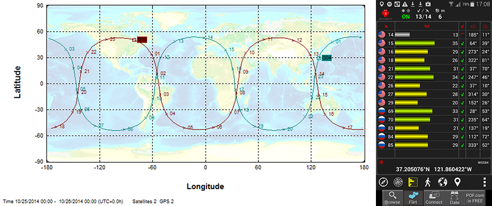
    In this course assignment, the map predicts the satellite paths, and the app is what students use to observe them.

    Final results are not yet in, but early indicators presage that Monday’s inaugural webinar with two Stanford professors will be the largest GNSS public event ever staged. Enrollment surpassed 20,000 some time ago, and the free subscription rolls are still open. It’s massive!

    Per Enge, professor of engineering at Stanford University, where he directs the Stanford Center for Position Navigation and Time, and Frank van Diggelen, vice president of technology at Broadcom Corporation and a consulting professor at Stanford University, are teaching the massively open online course (MOOC) on GPS this fall. The six-week course began October 13 and lasts through November 24, but it’s not too late to enroll.

    The course focuses on GPS basics with the use of smartphones.“This is the first ever MOOC on GPS/GNSS,” said van Diggelen. “It will be carried by Coursera.”

    GPS: An Introduction to Satellite Navigation, with an interactive Worldwide Laboratory using Smartphones

    Explore the fundamentals of the Global Positioning System (GPS) and how it works by conducting “backyard” laboratory experiments on your own mobile device. Learn the basics of satellite navigation and witness the power of a network with planet-wide coverage. Gain a deeper understanding of GPS and its role in our lives, while interacting with a worldwide community of learners and backyard scientists.

    “Online learning, especially with MOOCs, is about to revolutionize teaching, and Stanford is in the vanguard,” van Diggelen added. “We’ve been teaching this course for several years at Stanford, and so this seems a very natural extension. We’re both excited by the possibility of reaching students all over the world, and by being part of the revolution.”

    He provided some sample questions from set of short quiz exercises that will form part of the course.

    • What is the repeat period of the apparent orbit from a fixed point on earth, of a GLONASS satellite with orbit period 8/17 of a sidereal day?
    • What is 27 W in dBm?
    • Why is the bandwidth of the GPS C/A code signal one million cycles/second when it only sends data at 50 bits/second?
    • How precise are the GPS pseudo-range measurements?
    • Why is the fundamental GPS measurement called a pseudo-range?

    There are even lab sessions. Participants will use their own smartphones or tablets.

    A sample lab assignment: Predict which of the two GPS satellites, PRN 20 and PRN 32 will pass closest overhead at your location. Go outside at that time and verify that the GPS in your smartphone can acquire and track this satellite. Post the results on the course site, and watch who saw the satellite before you, and who sees it next.

    “The class as a whole will follow these satellites around the world, as they tie us together in a global laboratory,” van Diggelen concluded, “using online apps that make the worldwide labs work.”

    Frank van Diggelen
    Frank van Diggelen

    Frank van Diggelen is vice president of technology at Broadcom Corporation, a consulting professor at Stanford University, and inventor of coarse-time GNSS navigation, co-inventor of Long Term Orbits for A-GNSS, and author of A-GPS: Assisted GPS, GNSS, and SBAS. He is also a frequent contributor to GPS World.

    Per Enge
    Per Enge

    Per Enge designs navigation systems that are safe and secure. He has worked on such systems for maritime and air applications. Two of these navigation systems have been deployed worldwide. He received his B.S.E.E. from the University of Massachusetts, and his M.S.E.E. and Ph.D. from the University of Illinois. Today, he is the Vance and Arlene Coffman Professor of Engineering at Stanford University, where he directs the Stanford Center for Position Navigation and Time. He was awarded the GPS World 2013 Leadership Award in the Signals category.

    For more information, visit the course page at Coursera.

  • Leica, Aibotix, and Headwall Offer Airborne Sensor Solution

    The Airbotix X6.
    The Aibotix X6.

    Leica Geosystems, Aibotix and Headwall Photonics are offering an integrated high-performance airborne sensor solution using a hyperspectral imager and the Aibot X6 unmanned aerial vehicle (UAV). The Nano-Hyperspec sensor is optimized for size, weight and power to enable aerial acquisition of all spectral and spatial data within the scene of interest. A UAV with integrated Headwall sensor has been successfully flown and was presented at InterGeo 2014, held last week in Berlin.

    Precision agriculture, forestry, geological research, and environmental monitoring are application areas that can benefit from the airborne hyperspectral imaging solution, the companies said. Equipped with the hyperspectral imager, the Aibot X6 can, for example, take pictures of fields or vineyards to determine the chlorophyll content, plant health, and invasive species, and offer farmers information on the state of the plants and harvest. By means of UAV and hyperspectral imager, farmers can measure before harvest, where the grain is driest or should be mowed first. Or, they can determine where rain has washed away fertilizer and where they must re-fertilize.

    For geological mapping, landfills and open mine sites can be overflown to quickly and efficiently track precious metals or minerals. Environmental monitoring and research to derive contamination of soil or water can be determined spectrally from the air quickly using the Aibotix UAV and Nano-Hyperspec sensor.

    The Nano-Hyperspec sensor measures 76.2 x 76.2 x 119.4 millimeters and weighs less than 0.68 kg. The sensor is integrated with a high-speed data processor and high-capacity flash storage. It collects image data across 640 spatial bands and 270 spectral bands with a Visible-Near-Infrared (VNIR) range of 400-1000 nm. The field of view is exceptionally wide, meaning that flight swath efficiency is maximized to cover as much territory as possible while the UAV is aloft. Further, it delivers crisp image data not only directly underneath the flight path but off to the edges.

    The integrated data storage is 480 GB, which will yield more than two hours at a frame-rate collection rate of about 100 fps, which is matched to the actual performance of the UAV itself. The direct-attached GPS with IMU yields the ability to generate ortho-rectified imagery data products.

    The Nano-Hyperspec comes pre-loaded with an airborne version of its Hyperspec III application software that manages sensor operation, image acquisition, and sensor performance while aloft. Hyperspec III software is designed to work in a complementary fashion with the GPS/IMU as well as incoming LiDAR data to collect spectral data and generate a completely integrated hyperspectral data cube.

  • Airbus, Exelis Partner to Provide ENVI Users Integrated Access to Imagery and Services

    Airbus Defence and Space and Exelis are teaming up to provide users of ENVI image analysis software a limited-time voucher offer for new imagery as well as easy access to the Airbus Defence and Space imagery archive through an application programming interface (API) plug-in integrated within Exelis’ ENVI software. The partnership between Airbus Defence and Space and Exelis helps to expand the network that makes imagery easily accessible to GIS users, the companies said.

    The voucher program will offer a specific amount of Airbus Defence and Space imagery free of charge with any new ENVI license purchase, starting October 1, 2014. ENVI combines advanced spectral image processing and geospatial analysis technology with a modern, user-friendly interface. ENVI users will be able to integrate the Airbus Defence and Space imagery they receive through this program seamlessly into the ENVI software for use in applications such as feature extraction, change detection analysis, target identification, and more.

    The partnership has enabled Exelis and Airbus Defence and Space to develop and integrate an extension in ENVI software that directly connects to the Airbus Defence and Space imagery archive via an API. This allows ENVI users the opportunity to search and discover the Geo-Intelligence imagery archive directly within their ENVI environment. Users will have access to a full range of fresh optical and radar imagery including 1.5m SPOT 6 and SPOT 7 and 50cm Pléiades data.

    “This agreement between Airbus Defence and Space and Exelis gives ENVI users easy access to a full range of fresh optical and radar imagery, providing them with more accurate results for their projects and helping them make better decisions,” said Bernhard Brenner, head of the Geo-Intelligence programme line of Airbus Defence and Space. “We are excited to see new opportunities developing with this growing partnership.”

    “This integrated approach modernizes the way that people will discover data and access new imagery in conjunction with their existing imagery or GIS layers,” said Stuart Blundell, general manager at Exelis Visual Information Solutions. “By letting ENVI users easily identify and geo-locate thumbnail previews of available imagery within an area of interest without leaving the ENVI environment, our customers will save time and make better decisions in mission and project planning and execution.”

    The voucher program will be available to new ENVI users as of October 1, and soon after all ENVI users will be able to search and discover the Airbus Defence and Space imagery archive.

  • Geneq Talks Pre-Launch of SXBlue III GNSS RTK Receiver at InterGeo


    Richard Desrochers discusses Geneq, Inc.’s pre-launch of its SXBlue III GNSS RTK Receiver while at the 2014 InterGeo Conference and Trade Fair held October 7-9 in Berlin.

    See more InterGeo videos at GPS World’s YouTube Channel.

  • Galileo Service Provision Delegated to the European GNSS Agency

    The European GNSS Agency (GSA) and the European Commission have concluded an agreement that delegates a range of exploitation tasks for Galileo to the GSA, providing a framework and budget for the development of services and operations through 2021.

    The signing of the Galileo Exploitation Delegation Agreement serves as an initial step towards the full Galileo Exploitation Phase.

    According to the governance structure set out in the Agreement for the Galileo programme, the European Commission is responsible for the overall programme supervision, the European Space Agency (ESA) is entrusted with the deployment phase, while the GSA is responsible for the exploitation phase.

    As to the exploitation phase, the GSA’s responsibilities include:

    • Provision and marketing of the services
    • Management, maintenance, continuous improvement, evolution and protection of the space and ground infrastructure
    • Research and development of receiver platforms with innovative features in different application domains
    • Development of future generations of the system
    • Cooperation with other GNSS
    • All other required activities to ensure the development and smooth running of the system

    “With Galileo, we aim to provide a tangible service to European citizens, and this Delegation Agreement ensures we have the tools and funding necessary to achieve this,” said GSA Executive Director Carlo des Dorides.

    The Galileo exploitation phase will be progressively rolled out starting in 2014-2015, with full operability scheduled for 2020.

    The agreement was signed between Daniel Calleja Crespo, director-general of the Enterprise and Industry Directorate-General at the European Commission and Carlo des Dorides, executive director of the GSA. The agreement specifically sets the actions to be implemented, the amount of funding provided, and the conditions for the overall management.

    The implementation period of the agreement runs until 2021, with a comprehensive review of its functioning by the end of 2016. The maximum current EU contribution amounts to EUR 490 million, which will cover procurement and grant activities, including the GSA-ESA working arrangements and a programme management reserve, along with related research and development activities. The financing of the full exploitation phase will be confirmed during a mid-term review before the end of 2016.

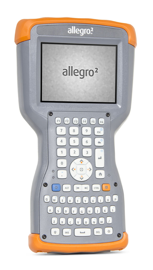
  • Juniper’s New Rugged Handheld Designed for Data-Collecting Efficiency

    The Allegro 2 by Juniper Systems. Photo: Juniper Systems
    The Allegro 2 by Juniper Systems. Photo: Juniper Systems

    Juniper Systems announced its newest rugged handheld computer, the Allegro 2, at the InterGeo 2014 trade show, held September 7-9 in Berlin. The handheld is the latest in the company’s Allegro product line, “with every bit of reliability,” the company says, but now with some major advancements.

    According to Juniper Systems, the Allegro 2 was designed for data-intensive applications, with meticulous attention paid to the engineering and design of the handheld to maximize efficiency and precision, both of which are critically important to high-volume data collection.

    Compared to the Allegro 1, the Allegro 2 has a newly designed keyboard in a QWERTY and numeric layout, with large, glove-friendly buttons for rapid — even non-visual — data entry. The new handheld features a custom Sun-to-Shade display that is 20 percent larger than the previous Allegro. It offers excellent visibility in any lighting conditions, the company said.

    The Allegro 2 is powered by an Overtime Technology battery, providing a 20+ hours of runtime. Its touchscreen uses capacitive technology, providing excellent durability, as well as crystal-clear imagery and greater sensitivity to touch, Juniper Systems said. The Allegro 2 has significantly enhanced GNSS performance, extended Bluetooth range, camera and video options, and a more powerful processor than the Allegro 1.

    “The Allegro 2 is our next-generation product, and it includes all of the latest enhancements available in its sister product, the Archer 2,” said John Florio, product manager at Juniper Systems. “The Allegro 2 was built from the ground up, based on user feedback on the jobs they have to do. Whether the customer is grading lumber in a log scaling yard, running a robotic total station, or performing a close-interval pipeline survey, the Allegro 2 is the best solution for the field today.”

    The Allegro 2 is scheduled to begin shipping in November.


  • New Version of PPP-Wizard Demonstration Software Published

    A new version of the open source PPP-Wizard user software has been published. The link to download the wizard is being provided on request, so the International GNSS Service (IGS) can keep track of interested users.

    The PPP-Wizard is defined as a precise point positioning with integer and zero-difference ambiguity resolution demonstrator. Available for non-commercial purposes, it performs real-time PPP using corrections streams provided by the IGS Real Time Service. It features:

    • GPS and GLONASS code and phase measurements (mono or dual frequency)
    • Ambiguity resolution on GPS thanks to the new standardized phase biases messages (with the compatible CLK91 stream)
    • Advanced RAIM
    • SBAS iono for single-frequency receivers (u-blox and nvs receivers)
    • Fast reconvergence using iono estimation
    • Compatibility with rtklib and BNC (rtrover interface)
    • Multiple receivers processing
    • Preparation for augmented regional networks (tropo & iono interface)
    • C/C++ portable and light implementation

    The PPP-Wizard demonstrator is a “proof of concept” of the zero-difference ambiguity resolution method developed in the orbit determination service at CNES.

  • CHC Navigation Showcases LT500 Series at InterGeo 2014

    Lance Andrew of CHC Navigation showcases its LT500 series and integrated head while at InterGeo 2014 held October 7-9 in Berlin.

    See more InterGeo videos at GPS World’s YouTube Channel.

  • Sokkia Announces Next-Generation Geodetic Reference Receiver

    Sokkia Announces Next-Generation Geodetic Reference Receiver

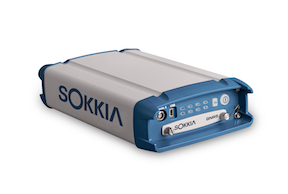
    The Sokkia GNR5 geodetic receiver. Photo: Sokkia
    The Sokkia GNR5 geodetic receiver. Photo: Sokkia

    Sokkia announces the latest addition to its line of geodetic GNSS reference receivers — the GNR5. Making use of 452 channels optimized to track the full GNSS spectrum, the GNR5 is designed to assign any visible signal to any available receiver channel.

    “The GNR5 is a comprehensive connectivity solution,” said Charles Rihner, vice president of the GeoPositioning Group. “Whether using the built-in Bluetooth and Wi-Fi wireless communication options, or standard Ethernet, serial and USB connections — the system provides a powerfully integrated reference station that is capable of tracking the GPS, GLONASS, Galileo, Beidou, QZSS and SBAS constellations.”

    Additional features include high-precision code and carrier phase measurements up to 100 Hz, Power over Ethernet (PoE), and advanced receiver management features.

    The new receiver is on display at InterGeo 2014, being held this week in Berlin.

  • Altus, Entegra Combine to Provide Tough Tablet with RTK Positioning

    The APS-GeoPod. Photo: Altus Positioning Systems
    The APS-GeoPod. Photo: Altus Positioning Systems

    Altus Positioning Systems, a Septentrio company, has integrated its APS-GeoPod product with Entegra Technologies’ Crossfire Pro Tablet. This collaboration, targeting the oil and gas, survey, GIS and transportation industries, provides a high-performance tablet-based solution for enabling ultra-precision RTK of sub-meter or centimeter accuracy.

    Altus is showcasing the APS-GeoPod and Crossfire Pro tablet, along with the full range of Altus products, at booth A1.060 and outside Booth FG.006 at InterGeo 2014 being held this week in Berlin, Germany.

    According to Altus CEO Neil Vancans, the Altus APS-GeoPod and the Entegra Crossfire Pro Tablet provide a combination of precision, performance and features that make it ideal for energy services, land surveys and other GIS-related applications.

    APS-GeoPod is a compact GPS/GLONASS RTK and DGNSS receiver that adds high-precision RTK positioning to USB-compatible tablet PCs. “This unique product gives users the convenience of adding RTK precision to any on-board application on mobile devices geared to the field service professional,” Vancans said.

    The Entegra Crossfire Pro tablet. Photo: Altus Positioning Systems
    The Entegra Crossfire Pro tablet. Photo: Altus Positioning Systems

    APS-GeoPod features include:

    • Compact dual-frequency GNSS module
    • Low power consumption (<1 Watt)
    • USB 2.0 interface
    • Internal L1 GPS/GLONASS antenna
    • NMEA integration with GIS software

    The Crossfire Pro tablet features the multi-touch interface and communication capabilities of smartphones, the large display and ergonomics of consumer tablets, and the daylight-readable screen and durability of rugged tablets. Safety features include UL 1604 Class I/Division II certification for operation in hazardous locations. To users, Crossfire Pro delivers a customizable tablet for exacting daily activities, resulting in greater efficiencies, response times, productivity and customer service levels, the companies said.

    Crossfire Pro tablet features include:

    • ADAPTIVE PERFORMANCE — Powerful, latest-generation processors, wireless communications, connectivity, and outdoor-viewable displays
    • ADAPTIVE EXPANSION — Standard and custom expansion modules — tailored to suit your workflow
    • ADAPTIVE CONNECTIVITY — Flexible user interactivity, including multi-touch displays (finger, glove and stylus), configurable I/O ports, clamshell keyboard and smart docking stations
    • ADAPTIVE RUGGEDIZATION — Variations in ruggedness to stand up to drop, shock, moisture, dust, temperature, and more.
  • Antcom Discusses Unmanned Systems, Geodetic Survey Antennas at InterGeo

    Robert Dumont of Antcom Corporation discusses the company’s unmanned systems antennas and geodetic survey antennas while at the InterGeo Conference and Trade Fair held October 7-9 in Berlin.

    See more InterGeo videos at GPS World’s YouTube Channel.

  • Topcon to Add 3D Mobile Mapping System to Product Lineup

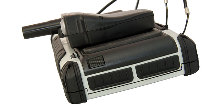
    The IP-S3 3D mobile mapping system, by Topcon.
    The IP-S3 3D mobile mapping system, by Topcon.

    Topcon Positioning Group will add the IP-S3 to its line of 3D mobile mapping systems by the end of this year. The fully integrated high-density digital imaging system is more compact, lightweight, and designed to scan at a rate up to five times faster than previous models.

    Scanning at 700,000 points-per-second, the system is designed to offer data-rich results with its 30 MP panoramic imagery. Weighing 18 kg (39 lb.), the IP-S3 is engineered to offer simplified installation.

    “The IP-S3 is a mobile mapping powerhouse,” said Charles Rihner, vice president of the Topcon GeoPositioning Group. “It bundles years of mobile mapping experience to glean a high-density and high-resolution camera in a unit that is much smaller than its predecessors. It is so lightweight that a single person could mount it on a vehicle without assistance from anyone else.”

    The system pairs with Topcon Mobile Master Office software to perform all post-processing functions in a single application.

    “Mobile Master Office software offers a complete workflow in a single package, turning raw sensor data collected by the IP-S3 system into rich and precise point clouds and images,” said Rihner.

    The system is planned for release in late 2014.