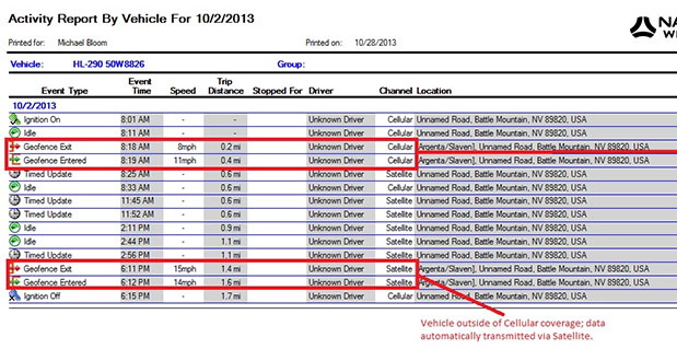
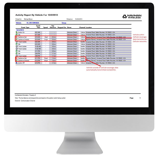
Navman Wireless USA today announced a new satellite communications option for its OnlineAVL2 fleet tracking platform, enabling continuous visibility of both heavy equipment and on-road vehicles even when assets are out of cellular coverage. Designed for construction, surface mining, mining and oil and gas exploration, and other environments with remote location work, the new solution includes the ability to minimize data charges by transmitting only the most critical event information via satellite.
Satellite connectivity is provided via a small modem that plugs into the serial port on Navman Wireless’ Qube on-highway or ruggedized Qtanium off-highway GPS tracking devices. The system automatically switches between cellular and satellite transmission with intelligent least-cost routing, using the global Iridium satellite network when fleet assets move out of cellular range. Benefits include:
Uninterrupted real-time fleet tracking without losing visibility of equipment location and other status information when assets are beyond the reach of cell towers.
Increased employee safety because equipment and vehicles are never out of sight of the fleet tracking system, even if they are working in cellular dead zones.
No missed engine alerts, potentially preventing costly machine repairs and downtime by ensuring that job supervisors are promptly informed when engine, coolant, transmission or air filter sensors connected to GPS tracking devices exceed pre-defined thresholds.
Cost-saving configurability, with the option to limit satellite transmissions to priority events (panic messages, rollover alerts, engine overheating, speed or geofence violations, etc.) and delay the transfer of low-priority event data until cellular coverage is restored.
“If a machine or vehicle in your fleet is operating outside of cell coverage and you have critical communications that need to take place for safety or operations reasons, it can be a problem to wait until the asset gets back into cell range,” said Davis Gammage, VP Product Management, Navman Wireless. “Temporarily switching to satellite communication solves the problem and ensures 100% visibility of your equipment as well as your field staff.”
The new satellite communications option marks the latest expansion of Navman Wireless’ fleet tracking portfolio for the construction, mining, and oil and gas industries. The company’s OnlineAVL2 fleet tracking platform provides location, operations and performance data for both on-highway vehicles and construction heavy equipment from a single interface. The back-end OnlineAVL2 application — delivered under the software-as-a-service model — includes industry-specific reporting such as jobsite utilization reports that break down equipment use by project, facilitate proper cost accounting, reduce writeoffs for unallocated asset hours, and aid in the development of future job bids for construction customers.
There is no doubt about it: drones (also referred to as UAVs and UAS) are a disruptive technology that will significantly impact geospatial professionals not only in the U.S., but around the world. While the mainstream media has mostly pushed the panic button with regards to privacy and drones, you don’t often read a discussion about using drones for mapping.
3D Matterhorn image produced from senseFly’s drone mapping effort.
In Switzerland, where drones weighing less than 30 kg (66 lbs) are legal to operate without a license as long as the operator maintains line of sight, drones mapped the famous Matterhorn Mountain (4,478 meters/14,692 feet) in the Swiss alps, at a resolution of 20 cm. This illustrates the power of drones for 3D mapping, and mapping in general. More efficient and less costly than traditional photogrammetry and airborne lidar, there is no doubt in my mind you will begin working with drones and/or data collected via drones in the near future. Of course, mapping the Matterhorn in 3D at 20-cm resolution is a monumental effort. Even using drones, senseFly reported that it took 11 flights, 5 hours and 40 minutes of flight time, and a total of 2,188 images to process covering 2,800 hectares (~6,920 acres). senseFly didn’t report how many manhours of post-processing the Matterhorn project required, but you know it must be a healthy number. Also, remember that Swiss regulations require that the drone operator must be within “direct eye contact” of the drone at all times, so you can bet the senseFly team had to do some serious mountain climbing.
While generating precise 3D images of a mountain certainly push the limits of drone technology, there are plenty of uses for mapping drones that make a lot of sense and are less complex. The Association for Unmanned Vehicle Systems (AUVSI) reports that in the United States, in the first three years of UAS integration more than 70,000 jobs will be created with an economic impact of $13.6 billion. AUVSI further reports that by 2025, the jobs number will increase to 100,000 jobs, and the economic value to $82 billion. Earlier this year, The Daily Beast reported that agriculture may end up being the largest user of drone technology. Other uses, according to AUVSI, include wildfire mapping, environmental mapping, disaster management, power-line surveys, oil and gas exploration, and general aerial mapping.
So what are we waiting for? Let’s start flying!
Not so fast. In many countries in the world, you can purchase a drone mapping kit and start flying tomorrow. Last month, I witnessed the massive offering of drones at the Intergeo 2013 conference. Copters and fixed-wing aircraft in all shapes and sizes were on display.
However, in the U.S. it’s not so easy. In fact, it’s illegal to operate any drone for mapping unless you have a special permit from the U.S. Federal Aviation Administration (FAA). If you think XYZ Corp. down the road who is using drones for mapping have such a permit, you are wrong. Despite the rumors and gossip you may have heard, and the fact that many companies are using drones for mapping in the U.S., it is not legal, by any stretch of the imagination.
Let’s have a look at what the FAA regulations state.
The FAA divides drone users into two categories: public and civil.
Public Users
Examples of public users by the FAA include the U.S. military and U.S. Customs and Border Protection, as well as other government agencies. Public users must apply for a Certificate of Waiver or Certificate of Authorization (COA) and adhere to the following guidelines:
The operator is required establish the drone’s airworthiness either from FAA certification, a Department of Defense airworthiness statement, or by other means.
The operator must demonstrate that a collision with another aircraft or other airspace user is extremely improbable.
The operator must comply with appropriate cloud and terrain clearance requirements.
The PIC (Pilot in Command), the operator in control of the drone, must maintain minimum qualifications and currency requirements.
An observer must be present to observe the drone and surrounding airspace via line-of-sight on the ground or via chase aircraft.
The PIC and observer must be within, generally speaking, one mile horizontally and 3,000 feet vertically of the drone.
Direct communications between the PIC and Observer must be maintained at all times.
As you imagine, these requirements are not easy to meet and issued to a select few entities. if you want to take a look at the list of Certificates of Authorization issued by the FAA, click here and scroll down to find links to redacted CoA awards that aren’t exempt from the Freedom of Information Act (FOIA).
As of February 15, 2013, the FAA reports there were 347 active COAs.
Civil Users
Civil users include any entity other than Public users, and includes commercial users.
Civil users must obtain an FAA airworthiness certificate just like you would need for any type of aircraft such as an airliner.
The FAA is issuing special airworthiness certificates in the experimental category for testing, market survey, and training of drones. The FAA is very clear that no Certificate of Authorization (CoA) or experimental certificates will be issued to commercial users. In fact, the FAA specifically states that drone users awarded an experimental certificate are not licensed to use drones for “hire or compensation.”
That’s it: short, sweet and to the point.
What about model aircraft users?
Interestingly enough, model aircraft users are allowed to operate drones and have a surprising amount flexibility in doing so. The guidelines for model aircraft users can be found here, but essentially the only concrete rules are that the “hobby” drone cannot exceed 400 feet AGL (above ground level), and that when flying within three miles of an airport, notify the airport operator. That’s it!
Even more interesting is that some hobby-class drones can be very useful for businesses. For example, last month I bought an AR Drone 2.o for US$370. The manufacturer calls it a quadracopter. It operates like a helicopter with four rotor blades. It’s controlled by an app that runs on your smartphone or tablet. I use a Samsung Galaxy III to control it. It’s amazingly easy to control with my smartphone.
AR Drone 2.0
I took the AR Drone 2.0 to the Field Technology Conference to demonstrate it and give conference attendees an idea of what is possible for very little expense. The response from attendees was a little surprising. I didn’t expect geospatial users to appreciate the limited capabilities of the AR Drone 2.0, but attendees spoke of applications like checking birds’ nests for eggs and close-up inspection of structures that aren’t easily accessible. After spending some time flying it, even I began to think about the inspection app and the ability to create video fly-throughs of golf courses, environmental areas, proposed developments, etc. The AR Drone 2.0’s forward-looking, high-definition camera generates stunningly crisp video.
So, that begs the question…
Why can’t a user, following the hobby rules (fly below 400 feet AGL), use the AR Drone 2.0 or any other drone for commercial purposes?
The answer is simple. The FAA rules state that you can use a drone all day long as a hobbyist (following the AC 91-57 rules), but once you start using it for commercial purposes, you are violating the law. Some drone users have said that to skirt the FAA rules, they don’t charge for drone flight time, but just the image processing (data) after the flight. I don’t think this concept has been tested in court yet, but the FAA says this activity is illegal.
“They would be violating FAA rules,” says FAA Spokesperson Alison Duquette. “Please read this policy link. The FAA recognizes that people and companies other than modelers might be flying UAS with the mistaken understanding that they are legally operating under the authority of AC 91-57. AC 91-57 only applies to modelers, and thus specifically excludes its use by persons or companies for business purposes.”
To understand how serious the FAA is about enforcing the no-business-use of hobby rules, I asked the FAA for a list of enforcement citations, cease and desist orders, etc. I was told I had to file a Freedom of Information Act (FOIA) request, which I did, but I’m warned by colleagues not to expect a speedy response.
Check out the following short (three-minute) video news report on a company in Minnesota that was “grounded” by the FAA for flying a drone for commercial use.
The good news is that in January 2012, the U.S. Congress ordered and funded the FAA to figure out how to integrate commercial drone use into the U.S. airspace by the end of 2015. In September 2013, the FAA released a document entitled “UAS Comprehensive Plan” and a document entitled “Integration of Civil Unmanned Aircraft Systems (UAS) in the National Airspace System (NAS) Roadmap“. If you’re really interested in learning more about drone usage in the U.S. and understand the FAA’s perspective, it’s worth a few minutes to scan these documents.
It’s going to be fascinating to see what rules the FAA establishes for commercial drone usage. Don’t be surprised if the PIC (Pilot in Command) must be a licensed pilot, and expect tough restrictions on altitude constraints, flight time, visibility, and control tower communications. I have my private pilot license (although I haven’t flown as PIC in years), and I recall that FAA rules state that you can fly as low as 500 feet AGL over rural areas and 1,000 feet AGL over populated areas. That doesn’t give commercial drone operators a lot of room to work with if they want to map a wide area.
TomTom released the 6th edition of its Traffic Index which reveals that on average, commuters around the world are spending 8 working days a year stuck in traffic.
According to the announcement, the Traffic Index is the world’s most accurate barometer of traffic congestion in 169 cities across six continents. It compares travel times during non-congested hours (free flow) with travel times in peak hours. The Index takes into account local roads and highways. Based on these comparisons, the report has compiled the top ten most congested cities, ranked by overall Congestion Level, in Q2 2013, these were:
1. Moscow
2. Istanbul
3. Rio de Janeiro
4. Warsaw
5. Palermo
6. Marseille
7. São Paulo
8. Rome
9. Paris
10. Stockholm
“We are seeing a clear pattern which shows that congestion levels increase as economies emerge from recession. The traditional responses to tackling congestion, like building new roads or widening existing ones are no longer proving effective. The way traffic is managed needs significant change,” says TomTom’s Chief Executive Officer, Harold Goddijn.
TomTom reports that the Traffic Index is based on detailed knowledge of the global road network and aims to help drivers, businesses and governments manage traffic congestion effectively.
“The findings from the Traffic Index also show that real-time traffic information has the potential to ease congestion in urban areas by routing drivers away from gridlock, and help commuters to make smarter decisions.” added Goddijn.
In the field, capture up to 200 MHz of multi-channel bandwidth and return to your lab with a rich library of GPS and GLONASS signals and impairments to accelerate RF product designs and research. Add a camera for a complete view and map of your recording environment.
Averna’s RF Studio software and suite of award-winning RF test instruments set the standard for portability, flexibility and repeatability, empowering you to efficiently record and play back all common radio, video, and GNSS signals in the highest fidelity to accelerate RF projects and reduce travel and testing costs.
RF Studio: A Powerful Software for Easy RF Recording
Available with Averna’s RF recorders and for National Instruments’ USRP, the versatile RF Studio features signal templates for quick setup and recording. With the Noise Figure feature you can view and record weak signals under the noise floor, and with the Spectrum, Power, and Histogram views you can visualize and analyze all your captured RF spectrum.
With the optional DriveView™ module, you can capture a complete visual record and map of where you made your recordings to aid analysis and troubleshooting. As well, RF Studio’s plug-in architecture supports additional hardware, channels, user inputs, remote triggering and a distributed control interface to ensure the widest possible application.
RF Studio is available with the following platforms
National Instruments’ USRP
RF Studio for the USRP is the only product on the market in its price range that offers the flexibility to cover a wide variety of use cases, thus making it a very competitive solution for general-purpose RF R&P. RF Studio gives NI USRP customers a turnkey RF R&P solution while also leveraging the flexibility and customization possibilities that have made this software-defined radio such a successful platform.
Averna’s RF Record & Playback Solutions
Our suite of RF test instruments sets the standard for portability, flexibility and repeatability, empowering RF device manufacturers to efficiently generate, record and play back all common radio, video, and navigation signals, ensuring complete test coverage and the highest quality for their RF products.
Multi-Channel, 50 MHz and 20 MHz Compact RF Recorders
Trimble introduced the next generation of its Trimble GeoExplorer data collection solution. The new Geo 7X includes an integrated laser rangefinder module, extended GNSS capabilities and improved hardware performance. Together with robust field and office software, the new Trimble Geo 7X handheld can enhance productivity in difficult physical conditions and challenging GNSS environments.
According to the announcement, when faced with either obstructed satellites or inaccessible locations, GIS professionals now have the geospatial data collection tools they need—in a single package. For times when occupying a position is simply not possible, users can take advantage of Trimble’s new Flightwave technology. With Flightwave technology, users can easily capture offset measurements from the Geo 7X’s rangefinder module for direct integration with Trimble data collection software. Users can simply point and shoot to log the position, avoiding dangerous conditions or right-of-way challenges. In addition, Trimble’s field-proven Floodlight technology enhances field productivity when heavy overhead cover obstructs satellite signals.
The Geo 7X is compatible with existing and planned GNSS satellite systems—including GPS, GLONASS, Galileo, QZSS and now BeiDou—to maximize productivity with additional satellites and ranging signals.
Featuring a new 1 GHz processor and 4 GB of memory running Microsoft Windows 6.5 Professional operating system, the Geo 7X offers enhanced computing performance. Other standard features include a 4.2 inch sunlight readable LED touch display and a 5 MP camera for geo-tagging assets. For wireless connectivity, the integrated modem allows users to send and receive data via GSM networks as well as Verizon’s CDMA network in the U.S. And with its IP65 rating, the rugged handheld GNSS receiver is sealed against water and dust.
With the introduction of the Geo 7X, Trimble also delivers updates to its field and office software portfolio to extend Trimble’s end-to-end data collection solutions with new software workflows and compatibility. In addition to the field-proven Trimble TerraSync and Positions software, the Geo 7X now supports the customizable data collection workflows of Trimble TerraFlex software. Consisting of mobile software and Cloud services, TerraFlex offers a fast and efficient way to collect, process and manage data. Field data is automatically synced with a central server to streamline office operations and drive higher productivity.
“We believe that true productivity is being able to map assets—the first time, every time and anywhere. We’ve built upon our productivity-enabling Floodlight technology and pushed it forward several steps,” said Alain Samaha, business area director of GIS and geospatial software solutions for Trimble’s Geospatial Division. “Users now can position themselves in the optimal location and accurately measure assets remotely with a single, integrated device together with simple software workflows. The Trimble Geo 7X allows mobile GIS users to be productive wherever they need to work.”
As you would guess, it takes a lot of planning and preparation to put on a technical conference of the scope of GEOINT. So imagine the hand wringing the USGIF staff went through deciding to postpone a conference of about 4,000 attendees and 300 exhibitors because of the untimely government shutdown. There really was no choice, with the majority of federal attendees canceling due to travel restrictions. Without their participation, holding the conference would have been futile. Since the city of Tampa was so accommodating and easy to work with, USGIF rescheduled the conference at the same Tampa venue, April 14-17. They tried their best to minimize scheduling conflicts with other geospatial and USGIF conferences such as the NGA Tech Showcase West (also scheduled for April) and USGIF’s GEOINT Community Week, including Tech Days.
Prior to a major conference, manufacturers send out press releases and invitations to see new products being shown on the exhibit floor. So, although GEOINT 2013 was postponed, I’m still doing my column as a “virtual conference” report. This is a very broad sample of new developments that I received from vendors who planned to be at the October conference, now rescheduled for April.
Thermopylae focuses on commercially-based knowledge-fusion capabilities in the geospatial, cloud, and mobile arenas. It has three solutions: iSpatal, a web-based collaborative framework that leverages Google Earth and Maps in a flexible, task-based approach to solve complex problems; iHarvest, a standards-based enterprise analytic service that organizes, analyzes, and reports activities to enable critical decisions; and Ubiquity, a proprietary platform for creating dynamic, customized, and geocentric native mobile applications. Thermopylae is also bringing back the popular Liquid Galaxy immersive virtual-reality display showcasing Google Glass and Leap integration, showing a unified demonstration of all of its products in the Liquid Galaxy display.
KEYW’s geospatial capability exploits cyberspace as a domain for collecting, processing, and supporting actionable imagery intelligence to the warfighter and for civilian and commercial uses. The company matches aircraft to mission requirements and modify the aircraft with integrated airborne sensor systems for onboard, geospatially referenced digital imagery collection and processing. KEYW planned to showcase its intelligence, surveillance, and reconnaissance (ISR) imaging and mapping; and its Precision Geo-location via handheld, backpack and mobile solutions, along with several other innovations.
Brocade provides networking solutions for government agencies and has expanded its product line with a new compact, fanless switch that simplifies network operations. It’s a secure, enterprise-quality network that is responsive to the complex needs of warfighter and civilian missions. The ICX 6450-C switch is deployable outside the wiring closet, without interfering with other critical activities. Using power over Ethernet, the switch can operate in remote locations, where access to an external power source is limited or not available.
TouchShare has extended its multi-touch solutions for immersive geospatial collaboration to anyone, regardless of location or device, through the TouchShare Mobile Access. The new TouchShare Mobile Access significantly improves teamwide productivity as it gives all collaborators the ability to simultaneously view and contribute to what other team members are seeing in real-time and interact with visual geospatial information (live data, 2D imagery, video, etc.) via any device. This allows all participants to easily and quickly see the big picture for making better decisions faster.
Surrey Satellite Technology provides small satellite solutions, applications, and services for Earth observation, science, technology demonstration, and communications. Since 1981, Surrey has launched 41 satellites as well as provided training and development programs, consultancy services, and mission studies for NASA, the United States Air Force, Los Alamos National Laboratory, and other institutional and commercial customers.
GameSim planned to show off its latest version of Conform, a software product for geospatial visualization. Conform imports, fuses and renders LiDAR content in near real time, while offering a variety of unique abilities, including an instantaneous 3D view of raw source data. Users are able to easily import large amounts of data (such as Shape Files, DTED, GeoTIFFs, LIDAR) and immediately view them in both 2D and 3D displays.
Hyperspectral sensing offers advantages over traditional multispectral imaging with respect to the number of spectral bands being covered. Use enhances target recognition, material identification, and elimination of false positive alarms. Hyperspectral imaging yields much more spectral data than multispectral by producing a continuous spectrum of data representing the chemical composition of objects or spectral “signatures” of everything within the sensor’s field of view. Headwall’s Micro-Hyperspec have been miniaturized and optimized for deployment aboard small, tactical UAVs, including small hand-launched versions.
Orbit Communication Systems provides ground-station solutions for Earth observation and remote-sensing applications. It has a new product family known as the Gaia series that supports a range of antenna sizes. These ground stations offer an ideal combination of high performance in a compact footprint. “With our new Gaia family, Orbit addresses a void in the market, and opens the door to new Earth observation markets that could not afford to purchase legacy ground stations due to their size and cost,” said Ofer Greenberger, Orbit CEO.
The antennas are designed to withstand extreme weather conditions and to handle a broad range of applications, operated anywhere on Earth. The series comprises three different sized antennas: 2.4 meters (7.9 feet); 3.7 meters (12.1 feet); and 4.5 meters (14.7 feet). Each antenna supports X-band or S-Band (both transmit and receive) feeds, as well as a dual-band (S&X) feed.
Astrium’s Street Factory, an advanced 3D urban mapping solution, was awarded “most valuable product in the geo-information field 2012” at the World Geospatial Developers Conference. Building on that success, Astrium planned to demonstrate WorldDEM, a high-resolution elevation data set that covers the Earth’s entire land surface, pole to pole. The accuracy of the German high-resolution radar satellites TerraSAR-X produces data intended to replace SRTM data. It has excellent ground-position accuracy with vertical accuracy of 2m (relative) / 10m (absolute) in a 12m x 12m raster GSD. WorldDEM will be available in 2014 with data less than 2.5 years old. Shown above is a comparison of STRM 90 elevation data compared to WorldDEM.
Ever since my experience supporting Katrina recovery efforts, I’ve be a strong advocate for simple low-tech hard-copy imagery plots overlaid with vector data to support emergency responders. Many times this low-tech embodiment of our high-tech capability suits the needs of first responders better than computer displays. However, paper plots ideally need to be laminated on foam core to be useful in wet and windy environments. Epson has one solution, a plotter that prints on ridged media. Epson engineers developed the SureColor T-Series printers with an all-new design that prints directly on ridged substrates that have a thickness of 1.5 mm. This is especially important to agencies that have a need for fast print output on thick media eliminating the hassle of laminating or marrying to thicker carriers for immediate use. The SureColor T-series also features Epson UltraChrome XD pigment-based ink technology for smudge and water-resistant prints.
This is just a sample of the nearly 300 exhibitors that will be at GEOINT in April. I’ll bet you thought that GEOINT was just imagery and big data. Quite the contrary — it takes a lot diverse players and pieces to build a strong GEOINT capability.
Since 2007, the worldwide scientific community has met every two years to discuss the possibilities for boosting the scientific use of Galileo and for contributing to the development of the GNSS.
The event is always organized in one of the 20 European Space Agency’s Member States, and makes an essential contribution to ESA’s implementation and definition of the evolution of the European GNSS. The gathering of major academic players provides a scientific reference for institutional executives and industry, as well as offering a unique platform for promoting innovative GNSS initiatives at large.
The colloquium focuses on four major areas of research:
Scientific applications in meteorology, geodesy, geophysics, space physics, oceanography, land surface and ecosystem studies, using either direct or reflected signals, differential measurements, phase measurements, radio occultation measurements, using receivers placed on the ground, in aircraft or on satellites.
Scientific developments in physics, dealing with future GNSS, particularly in testing fundamental laws in astronomy and in quantum communication. Relativistic reference frames and relativistic positioning will be addressed.
Aspects of metrology such as reference frames, onboard and ground clocks, and precise orbit determination.
Scientific aspects of satellite navigation and positioning such as signal propagation, tropospheric and ionospheric corrections and the means to model and mitigate multipath and interference.
The various possibilities to use navigation satellites such as Galileo for scientific purposes will be reviewed and the use of scientific applications to contribute to make the most of the present systems and define their evolution will be scrutinized.
The conference is being organized as a series of plenary talks and two parallel half-day sessions.
Linx Technologies announces its launch of the high-performance, low-cost RM GPS receiver modules. Using the built-in MediaTek MT3337 chipset, the RM module can simultaneously acquire on 66 channels and track on up to 22 channels, providing standard NMEA data messages through a UART interface. A simple serial command set can be used to configure optional features.
According to the company, the RM receiver module is a cost-effective GPS solution that offers no-frills, basic operation in a compact 15 x 13 millimeter package. The MediaTek MT3337-based RM Series is self-contained and only requires an antenna. It powers up and outputs position data without any software set-up or configuration, making the RM Series easy to integrate, the company said.
The receiver operates down to 3.0 volts and has a low tracking current of 12mA. The module has built-in receiver duty cycling that can be configured to periodically turn off the module for added power savings. This low-power consumption helps maximize runtimes in battery powered applications, such as consumer recreational positioning, marine, location and tracking, cargo tracking, and other asset monitoring systems.
In addition, the available GPS Master Development System connects a RM Series Evaluation Module to a prototyping board with a color display that shows coordinates, a speedometer and compass for mobile evaluation. A USB interface allows simple viewing of satellite data and Internet mapping, as well as custom software application development.
ABI Research forecasts that the global market for Driver Monitoring Systems (DMS) will reach 64.8 million units by the end of 2020 with the majority of shipments being accounted for in vehicles sold in the Asia-Pacific region. These findings are part of ABI Research’s Intelligent Transportation Systems Research Service and includes detailed installed base and forecasts of ADAS systems [advanced driver assistance systems] by regions.
Driver Monitoring Systems were first introduced as far back as 2006 when Toyota launched its innovative Driver Attention Monitor system. Toyota’s system functions by directly monitoring the driver’s face using a discrete in-dash camera and was initially offered as an option in the company’s luxury Lexus models. Other OEMs soon followed suit and announced their own DMS systems which were typically based on monitoring the vehicle rather than the driver’s face.
“DMS systems such as Mercedes-Benz’s ’Attention Assist’ and Volvo and Volkswagen’s ’Driver Alert’ systems were the first ADAS systems to be offered as standard equipment by OEMs, albeit only in a small selection of models,” comments Gareth Owen, principal analyst at ABI Research.
Today, an increasing number of ADAS systems are gradually becoming standard equipment in new cars, particularly in some European and Japanese brands such as Volvo, Mercedes-Benz, Nissan Infiniti, Lexus, and Mazda, and more are being offered as options. Although some of the big U.S. brands offer ADAS features in their European models, they typically do not offer the same features in their U.S. models, although this is beginning to change. Ford is a good example of this with its Ford Focus model.
“Another very observable trend in 2013 is that ADAS features are migrating from the luxury brands into B, C, and even A segment cars. Typically, the focus here is on offering ADAS systems, mostly as options, designed specifically for low-speed urban driving,” adds Owen.
Prices are decreasing, too. For example, the European Ford Focus offers an emergency braking system plus lane departure warning and lane-keep assist, driver alert, and blind spot monitoring as an optional package for £550 ($880) in the UK. Meanwhile, Volkswagen offers its City Emergency Braking System for £225-£405 ($360-$648), depending on model, on its budget A segment Up! car. This uses a laser sensor to detect the risk of an imminent collision and is active at speeds under 30 km/hr (18 mph).
Northrop Grumman Corporation is applying a modular, open architecture approach throughout its product portfolio, allowing for rapid addition of new avionics capabilities for warfighters. Northrop Grumman is already applying the FACE Reference Architecture and interfaces to existing programs and products, including an embedded GPS/inertial navigation system for the Joint Precision Approach and Landing System and a highly adaptable mission equipment package.
Northrop Grumman will leverage the corporation’s expertise in open architecture to implement FACE requirements for both current and future programs, including the Black Hawk H-60L Digital Performance Plan program and Tech-Refresh Mission Computers for the H-1 Upgrade program.
The company plans to participate in demonstrations that will promote maturation of the FACE Reference Architecture by enabling companies to deploy their products in a functional, standardized FACE software environment.
Also, the company’s Transport Services Segment aligns with the FACE Technical Standard requirements and provides a standard interface that allows portable avionics applications to be integrated with a variety of architectures and aviation platforms.
“An open architecture approach is critical to the affordability, innovation and effectiveness of avionics systems,” said Ike Song, vice president of Northrop Grumman’s Situational Awareness Systems business unit. “We are using performance-proven solutions from across our corporation to offer highly flexible, affordable products that support reuse on various platforms.”
Northrop Grumman’s Common Mission Management System (CMMS) establishes a common foundation for affordable control systems to support a variety of the company’s unmanned products. Based upon open architecture standards and standard off-the-shelf commercial hardware and software infrastructures, the Northrop Grumman CMMS product line avoids the need for dedicated, custom-built command and control systems for individual platforms. Also, the Northrop Grumman CMMS product line enables pilots to operate a variety of dissimilar unmanned platforms using the same informational displays and control features, thereby improving mission effectiveness while reducing training requirements.
With its expertise in unmanned aerial systems (UAS), the Northrop Grumman team was instrumental in leading the FACE Consortium’s effort to align with the UAS Control Segment (UCS) information model, establishing a common conceptual data model and metamodel as a framework that defines rules and conventions for developing interoperable software components for unmanned aerial system ground control stations. Further collaboration under the UCS/FACE Memorandum of Agreement is anticipated in aligning the FACE and UCS standards.
Northrop Grumman is a leading global security company providing innovative systems, products and solutions in unmanned systems, cyber, C4ISR, and logistics and modernization to government and commercial customers worldwide.
Cambridge Consultants introduces radar-based technology detection system to help agricultural vehicles avoid collisions. The new radar system helps prevent this by protecting the perimeters of the vehicle from potential hazards – giving audible and visual warnings to the driver.
“We have identified a huge demand for this type of agricultural technology as we see a continued increase in advanced farming techniques in the face of impending population growth and food shortages,” said Gary Kemp, programme director at Cambridge Consultants. “We’ve created practical technology that’s simple to operate and install but is also low cost and incredibly effective.”
According to the announcement, the radar units are designed to be installed on the front and rear of a vehicle as well as on the boom ends, and can detect multiple collision hazards in a wide field of view which maximises coverage. The technology can process many different moving and stationary obstacles – and instantly send an alert to the driver to warn of a potential collision. The low-frequency (5.8GHz) system is based on standard manufacturing principles, making it a cost-effective solution. The patented short-range radar technology provides unbeatable performance from a compact, low-cost sensor. The sensor simultaneously tracks multiple objects in 3D over a wide field of view and up to 30m range. Real-time collision prediction algorithm identifies hazards early, giving the driver ample time to take avoiding action
The company will be showcasing its latest farming technology at the Agritechnica International Exhibition, November 12-15, in Hanover, Germany, hall 17, stand C38.
The annual Intergeo conference and trade fair, this year held October 8–10 in Essen, Germany, elicited three principal observations from the three GPS World staff who attended:
Unmanned aerial vehicles, particularly in micro-form factor, have exploded across multiple sectors of the industrial economy. Emulating GPS — and carrying GPS on board in most cases — UAV has become an enabling technology with far-reaching implications.
Mobile devices bearing GPS/GNSS have likewise exploded, with many more commercial makers and models of handheld survey/mapping devices and location-enabled tablets to be found in Europe than in the United States.
GNSS manufacturers from China are making major efforts to secure distributors and break into the international market. Several had substantial booths, noticeably larger than the fewer, smaller booths present at Intergeo 2012.
Like ION-GNSS+, Intergeo spans an industrial exhibit and a technical conference, but the emphasis in Germany is decidedly on the former.
The technical conference covers key topics from a geoinformational perspective: environment, climate, energy, disaster management, cartography, spatial data, land policy, geographic information systems (GIS), and satellite processes and geodesy. About 140 presentations in 40 subject areas drew 1,300 participants — slightly larger than ION-GNSS+.
But the real story here is the gigantic trade fair for geodesy, geoinformation, and land management, displaying GIS software and services, surveying equipment and accessories, data capture and processing, remote sensing photogrammetry, cartography, and much more — including a dizzying and frequently buzzing array of micro-UAVs.
These face less regulation Europe than in the United States, which has still to come to grips with the technology. Federal Aviation Administration rules are expected in 2015.
The 28,000 square-meter Intergeo exhibition space featured 505 exhibitors from 30 nations and drew an estimated 16,000 attendees from 80 countries — making it between eight and 125 times the size of the ION GNSS+ industry exhibit. Clearly, the German show has a different mission and a different mix of both exhibitors and attendees, spanning different bands of the GNSS application spectrum; and, its orientation is much more commercial.
Exhibitors at the two shows form sort of an old-fashioned Venn diagram: some exclusive to either show and some overlapping, appearing at both. Among the latter group were: JAVAD GNSS, Trimble, Hemisphere GNSS, Leica Geosystems, NovAtel, Septentrio, ComNav Technology, Topcon Positioning Systems, and Fraunhofer Institute.
Among GNSS companies showing in Essen but not in Nashville were Altus Positioning, AllSat GmbH, Carlson Software, CHC Navigation, Forsberg, Fugro Geospatial, and Hi-Target.
A final question proffers itself after three days amid this hubbub: Why is there not a North American show of this nature? The Esri User Conference comes closest, but it is vendor-specific. There would appear to be a niche for a 5,000–10,000 attendee tradeshow in this sector.
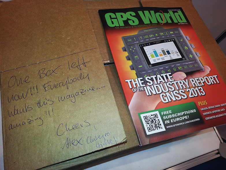
GPS World shipped 700 copies of the September issue to Intergeo; by the second morning of the three-day show, nearly all were gone, as attested by this note from our friendly bin stocker. Publisher Alan Cameron, Survey/GIS Editor Eric Gakstatter, and Associate Publisher Steve Copley attended, holding productive meetings with many exhibitors.
 Navman Wireless USA today announced a new satellite communications option for its OnlineAVL2 fleet tracking platform, enabling continuous visibility of both heavy equipment and on-road vehicles even when assets are out of cellular coverage. Designed for construction, surface mining, mining and oil and gas exploration, and other environments with remote location work, the new solution includes the ability to minimize data charges by transmitting only the most critical event information via satellite.