Blog

  • University of Maryland Leads Global Forest Loss/Gain Mapping Effort

    Source: Hansen, Potapov, Moore, Hancher, et al
    Source: Hansen, Potapov, Moore, Hancher, et al, 2013

    A multi-organizational team led by the University of Maryland has created the first high-resolution global map of forest extent, loss and gain. This free resource greatly improves the ability to understand human and naturally-induced forest changes and the local to global implications of these changes on environmental, economic and other natural and societal systems, members of the team say

    According to the announcement, the team of 15 university, Google and government researchers reports a global loss of 2.3 million square kilometers (888,000 square miles) of forest between 2000 and 2012 and a gain of 800,000 square kilometers (309,000 square miles) of new forest.

    Their study, published online on November 14 in the journal Science, documents the new database, including a number of key findings on global forest change.  For example, the tropics were the only climate domain to exhibit a trend, with forest loss increasing by 2,101 square kilometers (811 square miles) per year.  Brazil’s well-documented reduction in deforestation during the last decade was more than offset by increasing forest loss in Indonesia, Malaysia, Paraguay, Bolivia, Zambia, Angola and elsewhere.

    “This is the first map of forest change that is globally consistent and locally relevant,” says University of Maryland Professor of Geographical Sciences Matthew Hansen, team leader and corresponding author on the Science paper.

    “Losses or gains in forest cover shape many important aspects of an ecosystem, including climate regulation, carbon storage, biodiversity and water supplies, but until now there has not been a way to get detailed, accurate, satellite-based and readily available data on forest cover change from local to global scales,” Hansen says.

    To build this first of its kind forest mapping resource, Hansen, UMD Research Associate Professor Peter Potapov and five other UMD geographical science researchers drew on the decades-long UMD experience in the use of satellite data to measure changes in forest and other types of land cover. Landsat 7 data from 1999 through 2012 were obtained from a freely available archive at the United States Geological Survey’s center for Earth Resources Observation and Science (EROS).  More than 650,000 Landsat images were processed to derive the final characterization of forest extent and change.

    Source: Hansen, Potapov, Moore, Hancher, et al, 2013
    Source: Hansen, Potapov, Moore, Hancher, et al, 2013

    The analysis was made possible through collaboration with colleagues from Google Earth Engine, who implemented the models developed at UMD for characterizing the Landsat data sets.  Google Earth Engine is a massively parallel technology for high-performance processing of geospatial data and houses a copy of the entire Landsat image catalog.  What would have taken a single computer 15 years to perform was completed in a matter of days using Google Earth Engine computing.

    Hansen and his coauthors say their mapping tool greatly improves upon existing knowledge of global forest cover by providing fine resolution (30 meter) maps that accurately and consistently quantify annual loss or gain of forest over more than a decade. This mapping database, which will be updated annually, quantifies all forest stand-replacement disturbances, whether due to logging, fire, disease or storms. And they say it is based on repeatable definitions and measurements while previous efforts at national and global assessments of forest cover have been largely dependent on countries’ self-reported estimates based on widely varying definitions and measures of forest loss and gain.

    Dynamics from local to regional to global scale are quantified.  For example, subtropical forests were found to have the highest rates of change, largely due to intensive forestry land uses.  The disturbance rate of North American subtropical forests, located in the Southeast United States, was found to be four times that of South American rainforests during the study period; more than 31 percent of U.S. southeastern forest cover was either lost or regrown.  At national scales, Paraguay, Malaysia and Cambodia were found to have the highest rates of forest loss.  Paraguay was found to have the highest ratio of forest loss to gain, indicating an intensive deforestation dynamic.

    The study confirms that well-documented efforts by Brazil – which has long been responsible for a majority of the world’s tropical deforestation – to reduce its rainforest clearing have had a significant effect. Brazil showed the largest decline in annual forest loss of any country, cutting annual forest loss in half, from a high of approximately 40,000 square kilometers (15,444 square miles) in 2003-2004 to 20,000 square kilometers (7,722 square miles) in 2010-2011. Indonesia had the largest increase in forest loss, more than doubling its annual loss during the study period to nearly 20,000 square kilometers (7,722 square miles) in 2011-2012.

    Hansen and colleagues say the global data sets of forest change they have created contain information that can provide a “transparent, sound and consistent basis to quantify critical environmental issues,” including the causes of the mapped changes in the amount of forest; the status of world’s remaining intact natural forests; biodiversity threats from changes in forest cover; the carbon stored or emitted as a result of gains or losses in tree cover in both managed and unmanaged forests; and the effects of efforts to halt or reduce forest loss.

    For example, Hansen says, that while their study shows the efforts of Brazil’s government to slow loss of rainforest have been effective, it also shows that a 2011 Indonesian government moratorium on new logging licenses was actually followed by significant increases in deforestation in 2011 and 2012.

    “Brazil used Landsat data to document its deforestation trends, then used this information in its policy formulation and implementation. They also shared these data, allowing others to assess and confirm their success,” Hansen says.  “Such data have not been generically available for other parts of the world. Now, with our global mapping of forest changes every nation has access to this kind of information, for their own country and the rest of the world.”

    Global map of forest change: http://earthenginepartners.appspot.com/science-2013-global-forest

    Support for Landsat data analysis and characterization was provided by the Gordon and Betty Moore Foundation, the United States Geological Survey and Google, Inc. GLAS data analysis was supported by the David and Lucile Packard Foundation. Development of all methods was supported by NASA through its Land Cover and Land Use Change, Terrestrial Ecology, Applied Sciences and Measures programs (grants NNH05ZDA001N, NNH07ZDA001N, NNX12AB43G, NNX12AC78G, NNX08AP33A and NNG06GD95G) and by the United States Agency for International Development through its CARPE program.

    High-resolution global maps 21st-century forest cover change, Science, Nov. 15, 2013, Vol 342 #6160, authors M. C. Hansen, P. V. Potapov, S. A. Turubanova, A. Tyukavina, L. Chini, C. O. Justice and J. R. G. Townshend of the University of Maryland; R. Moore, M. Hancher and D. Thau of Google, Inc.;  S. V. Stehman of the State University of New York; S. J. Goetz of Woods Hole Research Center; T. R. Loveland of the United States Geological Survey; and A. Kommareddy, and A. Egorov of South Dakota State University.

  • Ubiquitous PNT and Sequestration: The World Runs on GPS Time

    A couple of years ago, wearing a different hat, I found myself on a guided tour of a key military C2 (Command and Control center) that was about as big as a football field and was to be deployed somewhere in Southwest Asia. My colleagues and I, who are all GPS SMEs (Global Positioning System Subject Matter Experts), asked the same question of almost everyone we saw that day. Near the end of the day and the tour, we had yet to receive an adequate answer. The typical response was, “Please save that question for our senior communications officer.”

    Finally, at the end of the tour and demonstration, we met the communications chief, and we once again asked our persistent and, for some of us paramount, question: “What would happen if we walked into this facility in the middle of a major military operation and activated a Coke-can-size GPS jammer that we were surreptitiously carrying in a backpack? In other words, what would happen if we disrupted your GPS signal reception?”

    The communications expert thought awhile and then answered. Unfortunately, the answer was a bit perplexing and yet all too common, inside the military and out. The communications officer hesitantly replied, “Well, this is a C2 center, and we are all about computers, networks and communications, and although I have to admit I don’t know much about GPS, other than we use it to navigate our military and civilian vehicles, I guess I would have to say it would not make any difference. In fact I am not even sure we would notice.”

    Quick as lightning, before I even had a chance to challenge the response or thought process, a grizzled old E9, who proved his operational savvy that day, interjected, “Beg your pardon, but all of our radios, computers, networks and communications gear are referenced and synchronized to GPS time. A GPS jammer would take us out of business until we brought up our backup atomic reference system. So, initially a Coke-can jammer activated in our facility would be catastrophic, but we would soon be back in business because we have backup atomic reference systems.”

    Fast-forward, and today that transition between GPS and atomic reference system is seamless. There is no down time, and yet the systems still run on GPS time. But during that initial visit, I could tell by the looks on the junior communications officers faces that surrounded us that, while they appreciated the save by the old chief, they were also still wondering, just how pervasive is the actual impact of GPS time for computers, networks and communications?

    The answer is simple. The world as we know it today runs on GPS time.


    GPS — Time and Frequency

    This is unfortunately a scenario my colleagues and I encounter all too often. While it is not my intention to launch into GPS 101, it bears repeating that of the approximately 3.5-billion-plus users of GPS and PNT (Position, Navigation and Timing) systems in the world today, 90% use the signals for incredibly accurate time-keeping and frequency stability, not just for positioning and navigation.

    Indeed, GPS SVs (space or satellite vehicles) today typically contain either three or four atomic reference systems (atomic clocks), primarily long-term, stable Rubidium systems with shorter term stable Cesium clocks as a Primary Reference Source, that continually broadcast Stratum-1 timing signals with stability on the order of 1×10-E13 or a pico second (a trillionth of a second) or greater.

    For the mathematically challenged, that means the stability of the atomic clocks are such that if the GPS atomic reference system could be maintained in a perfect environment for the lifetime of the clock, nominally 20-30 years for Rubidium systems, it would never lose a second of time. To put this number in perspective, consider that the navigation revolution (easily the biggest change in navigation since the sextant was invented) brought about by Harrison’s chronometer, perfected in 1759, allowed accurate navigation by Longitude and Latitude, by keeping and transferring time aboard ships with accuracies in the 10-second range over periods of weeks. And even though at the time it was hailed as a chronometer, its lack of accuracy is such that most navigators today could not tolerate the inaccurate time or lack of stability, not when they can measure time to the trillionth of a second or better simply by receiving a free GPS timing and frequency signal available globally.

    Interestingly, the clocks on the Boeing IIF GPS satellites (currently four SVs on orbit), which certainly have other issues, are proving to be the most stable Rubidium atomic reference systems ever flown in space to date, as they are currently displaying an unexpectedly high degree of frequency stability. Hopes are that future spaceborne atomic reference systems (such as in the GPS III LMCO SVs) may achieve two orders of magnitude greater stability at 1×10-E15. Compared to Harrison’s chronometer, that is an improvement on the order of 17 orders of magnitude!

    Now, if you are still wondering what all this clock stability means to you, consider that one nanosecond, or merely one billionth of a second, equates to a foot of positioning accuracy on the Earth, but even more importantly, for 90% of GPS users globally, time and frequency stability equates to an incredible, dependable, stable, ubiquitous timing source for the initiation and synchronization of networks and communications systems worldwide.

    When you consider that almost everything we do today involves timing, networks, computers and communications in some form, it also means that when we consider our (United States) Critical National Infrastructure (there are 16 critical infrastructure sectors defined today), all 16 depend in some form or function on GPS time and frequency stability. That is a sobering thought, and is exactly why we often use the words “ubiquitous” and “utility” when referring to the Global Positioning System. Make no mistake about it: almost every major country you can name today has the same dependency on time and frequency stability for their Critical National Infrastructures, and the majority use GPS as their primary timing, frequency and/or reference source.


    Dependence

    Some of you — and you don’t necessarily have to be a conspiracy theorist to think this way — will immediately see this dependence on one space constellation or system as a vulnerability. You would be correct, if there were no backup systems, augmentations or alternatives. Fortunately, just like the military C2 center, the majority of our Critical National Infrastructure sectors today have interim or temporary backups. While you should view that as a fortunate circumstance, it is also the limiting factor, or LIMFAC, in our infrastructure; the majority of the backups are terrestrial, oftentimes temporary in nature, and they rarely have the same degree of coverage, reliability or stability of GPS.

    Many of you may still be saying to yourself, so what? Here’s the so what: without GPS timing and frequency stability, we as a nation may be able to generate electricity, but we would not be able to distribute it. We may be able to drill for oil and produce products such as gasoline and diesel, but we could not distribute them, and you would not be able to dispense or purchase them at the pump. You could earn money, but you would not be able to access your bank account or bank records online or at an ATM. All of these systems depend on computers, networks and communications, and they all depend on GPS time and frequency for synchronization. Get the point!?


    Knee-Jerk Reactions

    Unfortunately, this realization has led many of our senior leaders in the services and the federal government, who should know better, to make broad and blanket knee-jerk statements concerning the need to replace GPS that are entirely unwarranted. As I said earlier, if you think of GPS as a global utility, that is exactly what it is. Then you must treat it just like you would electricity, for example. Certainly much of the world runs on electricity, and as you have seen, much of the world also runs on or certainly depends on GPS timing and frequency signals.

    However, as much as we depend on electricity, we don’t scream “find another energy source” every time the lights go out due to a storm, or power cables are cut by an accident or a farmer’s plow. Instead, prudence dictates that we plan for these occurrences, and we utilize other temporary or alternative methods of generating electricity such as backup generators. Indeed, we routinely use solar power, wind power, and batteries to hold us over until the main power is restored.

    We should think of GPS in the same way. When the GPS signal is interrupted, we should not immediately call it unreliable. Rather, we should use atomic clocks, inertial systems, and other PNT systems until the gold standard GPS signals are once again available. The solution is all in how you parse the problem.


    eLORAN

    If there were only a persistent, wide-area, wireless solution to our problem. Fortunately, there is, and as a nation we are well acquainted with one answer and one solution, which in my opinion is the answer and a time-proven solution. For more than 70 years, since before WWII until 2010, we as a nation had the answer. The near-perfect backup and/or augmentation system for GPS was already in place; it was a coterminous system originally designated LORAN-A (long range navigation). The legacy system (LORAN-C) was in the process (90% complete) of being updated to eLORAN, a modern digital system, when inexplicably the current administration decided the entire project was a waste of money; it’s a well known government condition or disease better known as myopia or shortsightedness. Now that same administration is spending more money every year ($50M) to tear down the LORAN-C and existing e-LORAN infrastructure and remediating land at the 28 transmission sites. The annual cost of operating the e-LORAN system for one year ($16M) means these same funds could operate the eLORAN system for more than three years.

    The sad part is that while our government is wasting taxpayer dollars in a severely constrained, sequestered budget environment, destroying badly needed LORAN-C and eLoran infrastructure, the rest of the world is busy building modern eLORAN systems (there are currently ~75 LORAN towers in the world today) as a backup and augmentation to GPS — countries such as Great Britain, Japan, South Korea, and Russia with their CHAYKA system, just to name a few.

    A recent RNTF (Resilient Navigation and Timing Foundation) white paper (more on this new organization later) on GPS and LORAN points out that an independent think tank known as IDA (the Institute for Defense Analyses), an organization of which I am proud to be a member and which includes Dr. Bradford Parkinson, who many call the father of GPS, recently conducted a study on GPS and LORAN and recommended that, “an existing and outdated nationwide navigation system called ‘Loran-C’ be greatly updated and modernized to ‘eLoran’.’’ Such a system would provide a navigation and timing signal comparable with and complementary to GPS. The IDA study concluded that: “eLoran is the only cost-effective backup for national needs; it is completely interoperable with and independent of GPS, with different propagation and failure mechanisms, plus significantly superior robustness to radio frequency interference and jamming. It is a seamless backup, and its use will deter threats to U.S. national and economic security by disrupting (jamming) of GPS reception.”

    The story of how the United States, which pioneered LORAN, wound up without an eLORAN system today, would be comical if it were not so sad. It is a long and sometimes incredulous tale, as Shakespeare once said, “full of sound and fury,” that I will not take the time to relate; however, I will say that it is not too late. Indeed, if we were to merely admit our mistakes and take the money budgeted for one year of LORAN-C and eLORAN destruction, we could not only build an entirely modern eLORAN system (for ~$40M) but we could operate it for the better part of a year while we figured out ways to make it pay for itself, and believe me when I say there are numerous viable courses of action that make this a real possibility. Then we, as a nation, would not only have a 4,000 KW terrestrial backup and augmentation to GPS, but we would have a backup and augmentation for timing and frequency stability for all of our Critical National Infrastructure sectors that would be nearly impossible to jam or spoof. Consequently, if you can’t jam or spoof the backup, then why bother trying to jam or spoof the primary system, GPS? In this instance, a modern e-LORAN system becomes a security blanket for GPS as well. It is indeed a win/win proposition.


    NSPD-39 and RNTF

    Lest you think I am a lone voice crying in the wilderness, in 2004 President Bush issued a National Space Policy (NSPD-39) that addressed the problem of GPS dependence. The space policy directed DOT and DHS (Departments of Transportation and Homeland Security) to find a suitable backup and augmentation for GPS. Six years later, a new administration unabashedly began destroying the only viable system that currently meets the parameters spelled out in NSPD-39. Fortunately, there are many today in and out of government that think as I do, and fortuitously they are doing something about it.

    Several months ago, I wrote about Charles (Chuck) Schue and his new digital e-LORAN system at UrsaNav being tested and supported by a CRADA or Cooperative Research and Development Agreement with the U.S. Government, and I promise you an update on that endeavor soon.

    Now there is an independent non-governmental foundation, the Resilient Navigation and Timing Foundation (RNTF), that supports a P3, or Private-Public-Partnership, to help develop and fund eLORAN as a private/public leased service to the government, and any other interested parties for that matter. In other words, the foundation proposes, among other ideas, to build and operate a modern digital eLORAN system for the United States, for all the reasons mentioned earlier, and lease that service to the U.S. government among others. Using P3 means that in this sequestered budget environment there are no upfront development or deployment costs to the government, and yet the system that augments and backs up GPS and critical timing for our Critical National Infrastructure is in place and operating as a private entity, employing people, paying taxes and providing a critical service. As I said, a winning proposition for all concerned.

    If that were not enough, just this week the GAO came out with a report entitled GPS Disruptions: Efforts to Assess Risks to Critical Infrastructure and Coordinate Agency Actions Should Be Enhanced. You can find the highlights for the report at the following link: http://www.gao.gov/products/GAO-14-15. Once there, you can click on the PDF link for the report, which is about 58 pages. So, it is a hot topic, and one that can be easily solved once common sense again reigns in our government.


    What Is Don Reading?

    This month, I am going to recommend two edited books that are worlds apart in concept but are both highly related to the use of GPS, one theoretically and the other physically and fundamentally.

    The Global Positioning System: Theory and Applications, by Parkinson and Spilker.
    The Global Positioning System: Theory and Applications, by Parkinson and Spilker.

    The Global Positioning System: Theory and Applications,
    by Dr. Bradford Parkinson and Dr. James Spilker

    1996, American Institute of Aeronautics and Astronautics
    ISBN 978-1-56347-106-3

    This exhaustive two-volume compendium of GPS knowledge is my daily bible for almost any GPS technical query you can muster. The two volumes total 781 pages and, truth be told, they are certainly doorstops, and while they are essential to your encyclopedic knowledge of GPS, they are certainly not to be carried around as textbooks. They are reference books, and the kind that should remain in your library at home. I treat my copies very gingerly, since they are about to fall apart from constant use. Plus, both volumes are signed by both editors, since they are both close friends and colleagues — but that is not why I recommend them. If Dr. Bradford Parkinson is the father of GPS, then Dr. James Spilker is the father of the GPS frequency and signal structure. Both Brad and Jim are currently Professors Emeritus at Stanford University and we visit on a regular basis, but again, friendship does not enter into my recommending these volumes.

    I recommend them because they are simply the best compiled and edited volumes on GPS that exist today. They are authoritative and technical to a fault. As I said before, the word exhaustive comes to mind, and frankly, I don’t know how any GPS aficionado or SME could make it through the day without these incredible reference tools. I know from first-hand knowledge that both Brad and Jim have been approached about an updated edition, but I don’t know how they would find the time. They are both in great demand and are constantly writing and speaking about GPS in venues around the globe. But it would be wonderful if they could fit it in. Now a digital, searchable version — that would be something.

    Guide to Super Snipers, Soldier of Fortune Magazine, edited by Brown and Spencer.
    Guide to Super Snipers, Soldier of Fortune Magazine, edited by Brown and Spencer.

    Guide to Super Snipers, Soldier of Fortune Magazine,
    edited by Lt. Col. Robert K. Brown and Vann Spencer

    2013, Skyhorse Publishing
    ISBN 978-1-62636-067-9

    This book is an edited history of snipers and their equipment that in the last 15 years has included GPS and other PNT systems on a consistent basis. Soldier of Fortune magazine and the editors interviewed literally hundreds of snipers around the world, and this is their story. Some of the snipers made headlines, like Audi Murphy, and were popular American heroes. Others you will have never heard of, but that does not make them any less meaningful or important in the roles they have played keeping their country safe.

    This book includes great details about legacy and current sniper rifles and the expert marksmen behind the scopes and sights. It may be more than you ever wanted to know about the art and science of snipers, but it is an inspiring and patriotic book that many will thoroughly enjoy. Be aware there are numerous typographical and grammatical errors — try not to let that impair your enjoyment of this one-of-a-kind book.

    Until next time, visit the RNTF site, support eLORAN, read a good book, and I wish you happy navigating.


  • Drone Moans and Satellite Woes


    As some of you may know, I also write a monthly column for Geospatial Solutions, which is all about geospatial technology encompassing GIS, surveying, engineering, and anything regarding geospatial technology. On occasion, I write something that fits very well with both my Survey Scene newletter and Geospatial Solutions Monthly newsletter. This is one of those months.

    Drones, UAVs, UAS…whatever you want to call them, are getting a lot of press coverage, both in the mainstream media and the surveying trade media. Rightly so — there are a terrific number of uses for drones in surveying and mapping from forensic mapping to crop monitoring to creating terrain models for volume estimations. A little later below, I’ll give you a link to my more detailed article about applications and my personal experience.

    In this article, I’d like to focus on the U.S. law regarding using drones for commercial purposes (eg. mapping, surveying, etc). I’ll start with a blanket statement.

    Under the current law, it is illegal for any commercial entity to operate a drone in the U.S. Period. 

    The only exception is that the Federal Aviation Administration (FAA) is issuing special airworthiness certificates in the experimental category for testing, market survey, and training of drones. However, the FAA specifically states that drone users awarded such an experimental certificate are not licensed to use drones for “hire or compensation.”

    The only other possibility is if the commercial entity has an airworthiness certificate for the drone like what’s required for any other aircraft such as an airliner. However, you can bet that no drone within your price range has such a certificate.

    What about hobby users?

    This is where it gets interesting and where some commercial users think there is wiggle room.

    Under the current FAA rules, hobbyists (the FAA calls them modelers) can fly drones up to 400 feet above ground level (AGL) and must notify the airport operator if flying within three miles of the airport. Hobbyists are covered under the AC 91-57 rules, a simple one-page document.

    Some (maybe many) companies and/or individuals who are operating drones for mapping in the U.S. think this is a loophole in the FAA rules, and that as long as they do not charge for the drone flight-time, they are not violating the FAA rules (they say they only charge for processing the data). The FAA begs to differ. When I asked the FAA this question, FAA Spokesperson Alison Duquette responded:

    “They would be violating FAA rules. Please read this policy link. The FAA recognizes that people and companies other than modelers might be flying UAS with the mistaken understanding that they are legally operating under the authority of AC 91-57. AC 91-57 only applies to modelers, and thus specifically excludes its use by persons or companies for business purposes.”

    This begs the question, is the FAA following a “don’t ask, don’t tell” informal policy? The best way to determine this is to look at their enforcement activity. When I asked the FAA if it would send me the list of enforcement activity regarding drones, the agency said I’d have to submit a Freedom of Information Act (FOIA) request, which I did this week. I’m told by my colleagues it may take some time before I get a response.

    I know of at least one instance where the FAA told an entity to shut down its use of drones. Take a look at this three-minute CBS news video.

    My Geospatial Solutions article “Is it Legal to Fly Drones for Mapping in the United States?” explores this topic in more depth.

    Let’s talk a little about RTK

    Last month’s article about post-processing alternatives, “Seven Free Alternatives to OPUS GPS Post-Processing During U.S. Federal Government Shutdown,” was one of the all-time, most-read articles ever published on the GPS World website. It’s ironic because I’m not a fan of post-processing in general. Mind you, I coordinated the development of several post-processing (both L1 and L1/L2) software packages back in the 1990s, so it’s not like I’m afraid to post-process or don’t understand the technology. It’s just that it’s so inefficient compared to RTK. However, I do concede that OPUS, AUSPOS, CSRS, Centerpoint RTX, GAPS, Scout, and MagicGNSS online post-processing tools combined with an increasing number of publicly available, worldwide GNSS reference stations make centimeter-level post-processing a lot easier (and less expensive) than ever before. It seems like a lot of you still prefer it!

    RTK technology is advancing too, from both a receiver perspective and a satellite system perspective. Which geographic region of the world do you think is the most well-suited for RTK positioning?

    It may seem like an odd question, and it would have been to me had I not attended the ION GNSS+ conference in Nashville, Tennessee, in September and the Intergeo 2013 conference in Essen, Germany, in October. How could one geographic region be significantly better for RTK positioning than another? Terrain? Nope. It’s the same country that consumes more L1/L2 receivers than any other country in the world: China.

    Why China? A picture (well, two pictures) is worth a thousand words:

    BDS
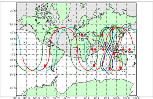
    BDS (BeiDou) orbit plot.
    Beidou_Navigation_Satellite_System_2012
    BDS (BeiDou) coverage map.

    At this point, China’s BeiDou (now referred to as BDS) navigation system is a regional system. If you look at the above graphic of the BDS satellite orbits, you can see the satellite figure eight orbits above southeast Asia. These satellites, combined with GPS and GLONASS, give the RTK user a tremendous number of usable satellites. Furthermore, since the BDS satellites are in figure-eight orbits, they stay “in view” longer ,which is ideal for RTK.

    The result is that GNSS users in the BDS coverage area have more satellites in view than any other region in the world, and we all know that more satellite observations make for better RTK positioning.

    China’s plans don’t stop with BDS being a regional system. By 2020, China says it plans for BDS to be a global system similar to GPS and GLONASS. The BDS presenter at ION GNSS+ said, “China always regards BeiDou belonging to both China and the world.”

    GPS and Galileo Delays

    Meanwhile, as it seems China is pushing forward, both GPS and Galileo suffered delays last month.

    The fifth GPS IIF satellite (IIF-5) launch scheduled for last month was postponed. A fuel leak in the Delta 4 launch rocket seems to be the culprit. No new launch date has been scheduled for IIF-5. The United Launch Alliance (ULA) issued the following statement:

    “The ongoing Phase II investigation has included extremely detailed characterization and reconstructions of the instrumentation signatures obtained from the October 2012 launch and these have recently resulted in some updated conclusions related to dynamic responses that occurred on the engine system during the first engine start event.

    “The GPS IIF-5 Delta IV launch is being delayed to allow the technical team time to further assess these updated conclusions and assess the improvements already implemented and determine whether additional changes are required prior to the next Delta IV launch.

    “The Delta IV booster for the GPS IIF-5 mission has completed the standard processing and checkout on the launch pad and will be maintained in a ready state for spacecraft mate and launch pending completion of this assessment. A new launch date will be established when the assessment of the updated dynamic response information is completed in the coming weeks.”

    Meanwhile, Europeans have been waiting on pins and needles for the first production launch of dual Galileo satellites. A fall 2013 launch date was expected, but has been postponed until Summer 2014.

    According to European officials, the European Space Research and Technology Centre (ESTEC) thermal vacuum chamber for testing satellites under orbit conditions was not ready for the two FOC satellites delivered by OHB in late summer.

    The satellites thus cannot ship to the Guiana spaceport in South America in time for a planned 2013 launch on a Soyuz rocket. The Galileo schedule is also running into bottlenecks with scheduled launches by other satellite programs aboard Guiana Soyuzes.

    A six-week test of the first Galileo satellite at ESTEC reportedly got under way in October.

    The pressure is rising for Galileo to start delivering usable satellite observations, which China is already doing, albeit for themselves and their neighbors.

    See you next month.

    Follow me on Twitter at https://twitter.com/GPSGIS_Eric

  • SPOT Offers Trace Theft-Alert Tracking Device

    SPOT Offers Trace Theft-Alert Tracking Device

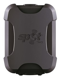
    SPOT Trace
    SPOT Trace

    SPOT LLC, a wholly owned subsidiary of Globalstar, Inc., has launched its SPOT Trace anti-theft asset tracking device. SPOT Trace ensures cars, motorcycles, boats, ATVs, snowmobiles and other valuable assets are where they need to be, notifying owners via email or text when movement is detected anytime, anywhere. SPOT’s growing family of products uses 100% satellite technology to provide location-based messaging and emergency notification for on or off the grid communications.

    SPOT Trace users can view their boat, ATV, motorcycle or other asset’s GPS coordinates online 24 hours a day in near real-time through Google Maps. With multiple mounting options, SPOT Trace is small and durable enough to be placed practically anywhere. With up to 18 months of battery life, affordable rate plans and satellite coverage that goes beyond the reach of cellular coverage, there is no comparable product on the market to track anything, anytime, anywhere. Other SPOT Trace features include:

    • Tracking. View your asset’s GPS coordinates from your smartphone or online
    • Movement Alerts. Receive texts/emails when SPOT’s vibration sensor detects your asset has new movement
    • Dock Mode. Configure your device to track an asset that is primarily stored on the water
    • Power Off Message. Receive a notification if your device is powered off
    • Low Battery Message. Receive a notification when the device’s batteries are low
    • Status Message. Receive a once per day alert to let you know your asset is secure

    SPOT Trace also features customizable tracking, which allows users to track an asset’s GPS coordinates at 2 1/2, 5, 10, 30 or 60 minute
    intervals. The units will sell starting at $99.95, with service plans from $99.99/year.

  • 1 Billion Smartphones with Location-Based Sensor Fusion Expected by 2016

    As smartphones embrace always-on, ubiquitous location, location-based sensor fusion will become a standard feature. ABI Research’s report, “Location-based Sensor Fusion: Companies, Technologies, and Revenue Opportunities,” outlines how sensor fusion will evolve to support indoor location and the companies best placed to succeed in this space. Location-based sensor fusion will enable the dawn of the quantified self, ambient intelligence, as well as provide huge potential around advertising and retail, ABI Research said.

    Senior analyst Patrick Connolly comments, “Sensor fusion is vital in enabling a consistent location experience, RF mapping, and the industry to scale rapidly. Unfortunately, it is not just a case of putting in a 9-axis sensor to achieve this. Highly complex algorithms are required to optimize sensor outputs, integrate with other location technologies and combine with machine learning and data-fusion algorithms. Sensor fusion will surpass Wi-Fi and BLE as the most important handset-based indoor location technology by 2017.”

    ABI Research has forecast the adoption of different indoor location technologies, and the companies best placed to be successful. “We see a significant trend towards hybridization, with Wi-Fi, BLE, and senor fusion proving to be vital. By 2014, hybrid solutions will have already surpassed standalone indoor location technologies on smartphones. Longer term, technologies around optical light, object recognition, and LTE-direct are all forecast to offer differentiation,” continues Patrick Connolly.

    VP and practice director Dominique Bonte adds, “The market is largely divided between Sensor IC OEMs, GPS/connectivity IC OEMs, and a group of really interesting start-ups. Companies like Movea, HillCrest, indoo.rs, and Senionlab are creating some intriguing solutions and will represent the next generation of acquisitions and partnerships in indoor location.”

    These findings are part of ABI Research’s Location Devices Research Service, which includes Research Analyses, Market Data, Insights, Presentations, and Competitive Assessments focused on the indoor location market.

  • Trimble’s Connected Farm Adds Precipitation Monitoring

    Trimble has announced a new feature for its RainWave precipitation monitoring solution for agriculture. As part of the Connected Farm solution, the new feature adds actual rainfall activity in 10-minute increments plus accumulated rainfall over a 24-hour period. With this comprehensive rainfall information, farmers can have a better understanding of the rainfall intensity, which can be used to make more informed decisions for irrigation and other farming operations.

    For example, if RainWave information shows that a large amount of rain fell in a short period of time, much of that rainfall may have run off the field and be unavailable to the crop. In contrast, if the information shows a slow steady rain, farmers may assume that the rainfall has a better chance of being absorbed in the soil and can be available to the crop.

    “With RainWave’s added functionality, Trimble is placing another valuable piece of information in farmers’ hands,” said David Fitzpatrick, business area director for Trimble’s Agriculture Division. “By providing a better understanding of how rainfall may have impacted soil moisture levels, farmers can optimize their irrigation planning, fleet management and timing of materials application for nutrient and pest management.”

    The RainWave solution enables farmers across the U.S. to set up virtual rain gauges by entering GPS coordinates for identified locations in order to receive a rainfall report for those locations. Since on-site rain gauges are not needed, farmers no longer need to monitor dispersed gauges or manually track precipitation. Farmers are able to obtain the RainWave information through their Connected Farm dashboard, a Web portal that provides one centralized location for farmers to view key information impacting their operations.

  • Verizon Expands Asset Tracking Portfolio with Networkfleet Asset Guard

    Verizon Enterprise Solutions today announced the expansion of its asset- tracking capabilities, with the introduction of Verizon Networkfleet Asset Guard. Designed to fit seamlessly on Verizon’s existing Networkfleet vehicle tracking solution, Networkfleet Asset Guard runs on the Verizon Wireless network for fixed and moveable fleets such as trailers, yellow iron machines and generators.

    A lightweight device with a built-in wireless antenna that easily attaches to a piece of equipment for wireless tracking, Verizon Networkfleet Asset Guard includes a long-lasting battery that allows for reliable location tracking over multiple years. Using Networkfleet’s online application, business owners can track assets alongside fleet vehicles to determine exact GPS locations. Reports and alerts show if and when an asset has been moved, which asset is closest to a particular location or landmark and when assets are moved outside of a predetermined virtual perimeter, or geofence.

    “It is becoming more critical for businesses and other organizations to track all of their vital assets, including equipment and vehicles, to help maintain security and operational efficiency,” said Erik Goldman, group president, Verizon Telematics. “With Networkfleet Asset Guard, businesses and government agencies can easily locate their fleet assets and together with our other Networkfleet solutions make sure they are being used properly and efficiently. The combination of Asset Guard’s long battery life coupled with the variety of reports and alerts will help public- and private-sector organizations improve equipment utilization, better manage fleet operations and control costs.”

  • GLONASS to Be Required for Phones Sold in Russia

    Phones sold in Russia will have to use GLONASS or GLONASS + GPS as of 2014, according to a report from the Voice of Russia. Phones with only GPS will be illegal in Russia, and any mobile devices imported will have to support GLONASS.

    A new bill claims that in order to guarantee stable operation of a unified telecom network in Russia regardless of conditions, it’s necessary that the satnav system used be the one controlled by the Russian Federation. New requirements for mobile devices with satellite navigation capabilities are expected to follow.

    The authors of the bill note that after the bill is adopted, its requirements will cover all manufacturers and vendors of cellphones, making it impossible to sell a mobile device without GLONASS support.

    The Telecom Ministry and industry watchdog Roskomnadzor will oversee the changes.

  • Applanix Brings Trimble CenterPoint RTX Correction Service to Airborne Mapping Products


    Applanix, a mobile mapping and positioning company, is making the Trimble CenterPoint RTX correction service available across its entire airborne mapping portfolio. Applanix is a Trimble Company.

    Using the Trimble CenterPoint RTX correction service, Applanix will be able to deliver these benefits to the aerial survey marketplace:

    • High accuracy — better than 10 cm RMS horizontal after convergence
    • Speed and low cost — no need for setting up base stations, no need to wait for delivery of public-domain ephemeris data
    • Simplicity — deal directly with Trimble (no third-party involvement)
    • More uptime and reliability — use Trimble’s professionally managed, highly maintained private network
    • Ease of use — there is no additional hardware to purchase, integrate or maintain
    • Fast and reliable convergence — 30 minutes or less to full accuracy

    The announcement was made at Trimble’s China Dimensions User Conference. The CenterPoint RTX service for Applanix airborne mapping products is expected to be available in the fourth quarter of 2013.

    “The Applanix aerial mapping portfolio is trusted throughout the aerial mapping community to provide highly accurate position and orientation information for directly georeferencing camera and sensor data,” said Joe Hutton, Director of Airborne Products at Applanix. “By integrating the Trimble CenterPoint RTX correction service, we are maintaining our position at the forefront of accuracy, robustness, and high efficiency in airborne mapping.  The CenterPoint RTX correction service gives Applanix products the  ability to achieve accuracy required for many types of mapping projects in real time and post-mission, all without the need for base stations – an industry first.”

    Trimble CenterPoint RTX correction service is a GPS, GLONASS and QZSS enabled correction service built on Trimble RTX technology.  It provides high-accuracy GNSS positioning without the use of traditional reference station-based differential RTK infrastructure.

    The solution is also compatible with the Applanix POSPac software to achieve the same level of orientation accuracy as when using base stations, all without the need to have an Internet connection or wait for precise ephemeris data to be available.

  • Qinetiq, Rockwell Demonstrate Multi-Constellation Galileo/GPS Secure Positioning for Governmental Applications

    On August 30, QinetiQ and Rockwell Collins demonstrated the first joint satellite navigation positioning using live signals from the encrypted governmental services from the U.S. Department of Defense (DOD) GPS Precise Positioning Service (GPS-PPS) and the new European Galileo Public Regulated Service (PRS). The signals on GPS L1 and L2, together with Galileo PRS L1A and E6A, were processed and combined to form multi-frequency, multi-constellation position fixes.

    Positioning, navigation and timing (PNT) services provided by GNSS, such as GPS and the forthcoming Galileo system, are essential to underpinning both commercial and economic activity (the EC estimates 6-7% of the developed world’s GDP) and the delivery of governmental responsibilities including the safety and security of citizens.

    GNSS systems such as GPS and Galileo make use of very low power signals and are subject to inadvertent interference, deliberate jamming and spoofing (where an attacker generates a false signal masquerading as a valid one to mislead a user receiver). Attacks on GNSS may range from low-level criminal nuisance (a delivery driver stopping their employer tracking them), enabling theft of high-value vehicles fitted with trackers, through to state-sponsored attacks. This is potentially a significant concern for a wide range of governmental users including law enforcement, security and emergency services, critical national infrastructure, transport and defense users. The use of multiple independent, secured navigation services provides significant improvements to navigation robustness and, along with other measures, offers substantial counters to these threats.

    “This has been our first opportunity to explore how secured navigation services on GPS and Galileo can be used together to provide users with critical reliance on PNT with robust and continuous navigation services,” Nigel Davies, Head of QinetiQ’s Secured Navigation Group said. “QinetiQ is proud to be a key, long-term contributor to the Galileo Programme, having been working closely with the European Space Agency (ESA), the European GNSS Agency (GSA), European industrial partners and European Member States since 2003.  QinetiQ and Rockwell Collins wish to thank ESA, the EC and GSA for support in accessing Galileo, as well as the UK Space Agency, UK Satellite Applications Catapult and the UK MOD for their support.”

  • Topcon Acquires DynaRoad, Opens Technology Center

    Topcon Positioning Group has acquired DynaRoad Oy, a construction software company in Helsinki, Finland. In conjunction with the acquisition, Topcon also announced the establishment of the Topcon Helsinki Technology Center.

    In 2011, Topcon acquired a significant share of DynaRoad, a company that develops project management software specifically designed for large-scale construction projects — highway, tunnel, railway, area development and harbor.

    Ray O’Connor, Topcon president and CEO, said by acquiring 100 percent of DynaRoad, “Contractors and designers who are looking to cut construction costs through design optimization and better task management now have a strong central source for production management with DynaRoad being integrated to other Topcon systems. The new technology center in Helsinki has a strong foundation as the team has already worked with Topcon for approximately four years. We look forward to releasing new world-class products with them.”

    The DynaRoad software combined with Topcon’s Sitelink3D Enterprise, a real-time task management tool, creates “an integrated machine control solution for all phases of earthworks projects, from pre-planning to construction,” O’Connor said.

    Juuso Makinen, CEO of DynaRoad, said the acquisition “finalizes the close working relationship the two companies have had for years. This is a natural step to take as the integration of machine control and planning software enables us to automate many aspects of production management. Automating manual repetitive tasks such as task progress monitoring means our customers will have a better understanding of their site’s status and more time to spend on optimizing production.”

    “DynaRoad is a perfect fit to the Topcon organization,” said Ivan Di Federico, Topcon chief strategy officer. “The focus of their software and services is on construction economics — namely time and cost optimization. These products and experiences, together with Topcon’s machine automation and real-time communication, will bring our customers to the next level of productivity.”

    As a result of the acquisition, the DynaRoad products will be available through Topcon dealers worldwide.

    With the new Helsinki Technology Center, Topcon now has seven technology centers around the globe, including in Japan, Australia, Italy and Russia, plus two in the United States (Ohio and California).