Orolia has finalized the contracts to supply Rubidium atomic clocks (Rubidium Atomic Frequency Standard, RAFS) and passive hydrogen masers to equip eight satellites for Galileo’s Full Operational Capability Phase II program. The two new contracts, totaling 14.5 million euros, follows the authorization to proceed received in June 2012 for the manufacture of these two types of high-precision clocks.
Orolia brands include Spectratime and Spectracom. The announcement was made through Orolia subsidiary Spectratime.
Each Galileo satellite carries two Rubidium atomic clocks and a passive hydrogen maser, the most stable clock in the world, according to Spectratime. Once completed, this new contract, in partnership with Astrium and Selex Galileo, will make Spectratime the leading supplier in the world for active atomic clocks in space, including 72 for the Galileo system.
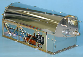
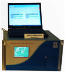
Rubidium atomic clock, or RAF.
Atomic clocks are used in satellite navigation because of their stability, low weight and high reliability. Very accurate time is used to precisely measure the path of radio signals from the satellites to Earth, and by calculation, the distance between the satellites and the Galileo receiver. The stability of these clocks is enough to guarantee geo-location accuracy of one meter with a fully operational ground infrastructure.
Spectratime said it has the expertise and capability in designing advanced maser physics packages for high-performance, high-reliability space applications, where the clocks need protection in the hostile space environment from radiation, magnetic fields, shock, vibration, or thermal variations.
SyncWorld will enable power utilities to react in real time to outages and alert users to contingency plans.
Symmetricom has introduced a new category to its SyncWorld Ecosystem Program dedicated to the power utility industry. Developed to support integration and interoperability among power utility and Symmetricom solutions, the SyncWorld Power Ecosystem aims to facilitate unified deployments of timing and synchronization in substation modernization and synchrophasor applications.
As power utilities shift to the Smart Grid, they gain the ability to monitor in real time, allowing for proactive operations control. Advanced synchronization and timing enable power equipment to operate more efficiently and closer to its operational limits.
For example, one microsecond accuracy is required by the phasor measurement unit (PMU) for real-time network situational awareness and overall operational efficiency. Without accurate time stamps, PMU data has limited value. For power utility companies, that translates into enhanced network utilization rates as well as smarter management and mixing of renewable and traditional power sources.
The introduction of the SyncWorld power segment is expected to drive collaboration and innovation among the industry’s leading power utility vendors. To participate in the program, vendors work with Symmetricom to develop a joint solution, complete successful solution testing, and commit to ongoing technical and business activities to ensure joint success.
Interoperability is a key requirement to join the program. Using various test cases with a defined standard for testing, Symmetricom focuses its assessment on the performance of a product’s IEEE 1588 power profile. During testing, Symmetricom clocks act as the master clocks, switches act as transparent clocks, and IED/PMU products act as slave clocks.
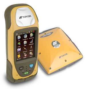
“With the addition of Vanguard technology, the GRS-1 fully integrated, dual-constellation, network-enabled receiver and controller optimizes tracking and performance regardless of job site conditions or location,” Scott Langbein, director of product marketing, said.
Topcon’s 226-channel Vanguard technology with Universal Tracking allows each individual GNSS channel to be fully optimized to track any of the available satellite signals that are supported in today’s GNSS receivers.
The GRS-1 can be used in various configurations from handheld to network enabled RTK measurement, and grade management. “The system can be configured to perform at various levels of accuracy that fit any budget and application,” Langbein said. Choices include centimeter level, sub-decimeter and sub-meter, with accuracy upgradeability options available.
Working with Topcon’s Magnet suite of software products, “the GRS-1 streamlines the workflow for surveyors, contractors, engineers and mapping professionals,” Langbein said.
The GRS-1 with Vanguard has DGPS capability with the internal single frequency antenna for use in GIS and navigation applications. Add the external antenna and connect a GRS-1 rover to a local GNSS network, or Topcon Magnet Relay, for centimeter accuracy RTK performance. Magnet Relay allows a mobile base receiver to host up to 10 rovers through the Magnet Enterprise “cloud.”
The GRS-1 has an optional 2MP built-in camera, integrated SD memory card slot, and includes an optional internal GSM or CDMA cellular modem and internal GNSS antenna, plus wireless connectivity via wireless LAN or Bluetooth technology.
CMTINC.COM announces the release of the Utility Data Collection app for the Apple iPad. This powerful GPS/GIS mapping and data collection app was mainly designed for utility asset management and meter reading. However, it could also be used by other professionals who need to map points, lines and areas and record pertinent information for the mapped Features, such as for fish & wildlife, natural resources, land management, oil and gas, archaeology, sales route management, and others.
According to the announcement, the Utility Data Collection app provides a dedicated data entry form for entering meter readings and other observations. The meter readers can opt to have the meter route displayed on a satellite map. They will be able to tell which meters have been read as the corresponding symbols will display in a different color on the map. They will also be able to sort and search the meter records. The import and export functions makes it easy to set up meter routes, upload meter database and export meter readings.
Between the monthly meter reads, the app can be used by the maintenance crew to map the locations and record the conditions of land plots, utility poles, utility meters and other equipment. The surveyed items can be easily tagged with pre-defined descriptions as well as photos taken on the spot.
The company reports that the Utility Data Collection app is the answer for small towns and utility cooperatives who are looking to transition to a newer and more effective utility management and meter reading system on a budget.
Blue Marble Geographics announced the release of a fully managed .NET version of the GeoCalc 6.6 software development kit (SDK). Now .NET developers can get all of the accuracy and power of the GeoCalc toolkit in a fully managed .NET control. Blue Marble’s geospatial data manipulation, visualization and conversion solutions are used worldwide by thousands of GIS analysts at software, oil and gas, mining, civil engineering, surveying, and technology companies, as well as governmental and university organizations.
According to the announcement, GeoCalc is a fully object-oriented class library for software developers. Available on a number of platforms, not only does it support a massive amount of geodetic objects out of the box but the tool also has a direct connection to the OGP’s EPSG Geodetic Parameter web registry. This allows you to directly update your EPSG definitions whenever you need it and to supplement our already huge database with even more objects for coordinate transformation. Blue Marble’s geodetic toolbox leverages an XML data source, enabling secure and powerful data transformation management through interfaces and logic that allow you to lock down your datasource via password protection. The toolkit includes a variety of tools for improving data quality management from a development level allowing the software developer to work with the survey expert to provide powerful coordinate transformation software. With the release of the fully managed .NET platform, developers now can get all of the accuracy and power of the GeoCalc toolkit in a fully managed .NET control.
“This fully managed version of GeoCalc has come about from working closely with a number of our developer customers over the past year,” stated Blue Marble President Patrick Cunningham “We’re pleased to make powerful, reliable coordinate transformation available for any software environment and happy to assist our customers at the same time. When we say customer driven development, we mean it.”
The company reports that the GeoCalc fully managed SDK is built on Microsoft’s 4.0 .NET architecture. This means all of the memory management details are handled entirely by the .NET virtual machine and the CLR (Common Language Runtime). Using this standard Windows framework increases security, performance, and usability for anyone working inside the latest Microsoft development environments. This new version of GeoCalc streamlines the development process as 32 and 64 bit compatibility issues are handled entirely by Visual Studio, and the new code base means only one application needs to be delivered for both environments. The single DLL redistributable framework makes windows deployment much easier in many cases, lowering development costs and speeding up time to market.
To fly a UAV in the U.S., you’d better be able to avoid any other aircraft — and ADS-B is one component of that capability. When the FAA and agencies around the world get their UAV regulations aligned with those levied on passenger-carrying aircraft, GNSS receivers on board UAVs will likely need to be qualified to equivalent standards. One company is already there.
When I was wandering around the show floor at the Association of Unmanned Vehicle Systems International (AUVSI) in Washington, D.C., in August, I got a pleasant surprise when I bumped into an old friend I knew from Calgary. Jayanta Ray was a grad student at the University of Calgary (U of C) when I was at NovAtel a few years ago. The students of the GNSS courses at U of C were often at local Calgary ION chapter meetings I organized or attended; there were also a few joint industry-university projects, and there were many, many discussions. So meeting Jayanta (Jay) at the Accord Systems/NexNav booth was a pleasant surprise, and it was good to renew our acquaintance.
This got me thinking that maybe some of that U of C receiver magic had somehow found its way through Jay into the airborne qualified receivers that Accord Technology is offering for UAVs. Jay is actually a member of the GPS World Advisory Board, and provides a great overview of what’s good and what’s different about airborne qualified receivers in this month’s issue of GPS World.
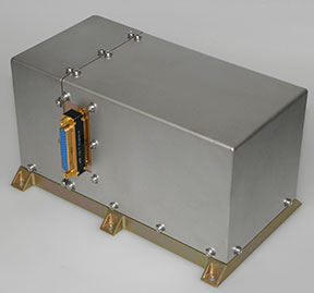
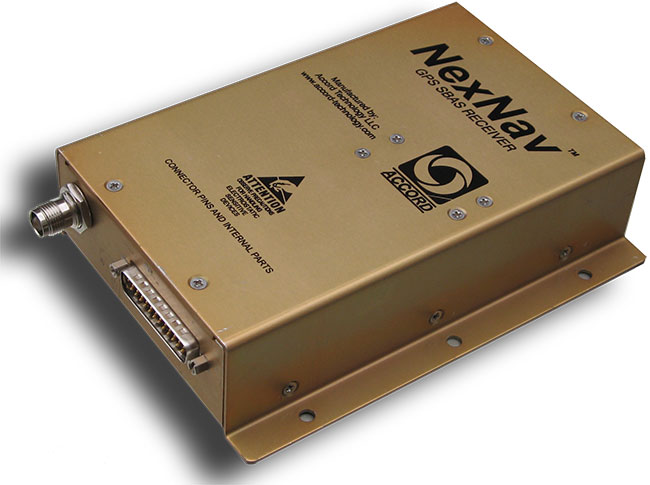
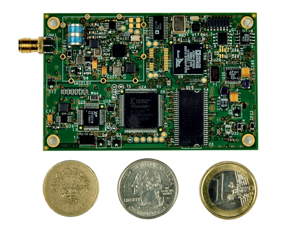
NexNav mini is also qualified for airborne GPS and ADS-B use.NexNav mini is also qualified for airborne GPS and ADS-B use.
Accord Technology is based in Phoenix, Arizona, and is the U.S. arm of Accord Software and Systems of Bangalore India, specializing in FAA-certified airborne versions of Accord’s GPS receivers.
At AUVSI, one of the hot topics was “Sense and Avoid” — if you are to fly a UAV in the U.S. National Airspace System (NAS), you’d better be able to avoid any other aircraft, and maybe also be able to tell other aircraft in the NAS where you are. ADS-B (Automatic Dependent Surveillance-Broadcast) is one component of that capability. ADS-B uses a network of ground stations that relay ADS-B transmissions from aircraft (called ADS-B Out) in the NAS to the Federal Aviation Administration (FAA) air-traffic management system, and the signal is also available to aircraft flying in the system if they are equipped to listen to the message (ADS-B In). Air Traffic Control (ATC) can then verify that you are where you are supposed to be, and your actual position shows up more readily on their tracking systems. Right now, ATC makes extensive use of radar tracking and aircraft transponder signals to track aircraft — ADS-B will be more efficient, less costly to maintain, and is capable of aircraft-to-aircraft position reporting. By 2020, it will be mandatory if flying within the U.S. NAS.
The other part of this story is that, eventually, when the FAA and other agencies around the world get their UAV certification regulations aligned with those levied on passenger-carrying aircraft, GNSS receivers on board UAVs will likely need to be qualified to equivalent airborne standards.
Accord has already done an enormous amount of work to qualify its NexNav receivers for both requirements, and was at the AUVSI conference to let the UAV community know that these receivers are available now. If you were developing a new UAV now, with a view to selling lots into the anticipated wide range of commercial applications, its certainly going to help your case with the certification authorities to install as much off-the-shelf certified avionics as you can. Accord already sells these receivers to a number of general aviation system manufacturers, and also supplies stand-alone ‘TSO’ed” receivers in enclosures for use on a number of aircraft types. When an airborne receiver is granted the TSO (Technical Standard Order) designation by the FAA, it recognizes that the receiver has been designed, built and qualified to stringent airborne technical requirements and is authorized by FAA for use on aircraft.
So how does a company with its HQ in India get to hold an FAA TSO for a GPS receiver? Well, other than taking years to develop the receiver in accordance with approved development standards, document the hardware and software design, and conduct test and verification activities, the company also proves to the FAA that the receiver meets the FAA-specified airborne GPS functional requirements. Loads of engineering work — and then you have to convince FAA that you did it all and did it right.
Accord in Bangalore actually teamed up with AvValues in Phoenix to form a joint venture known as Accord Technology (AT) to work the project together. Most of the original receiver development work was done in Bangalore, while AT in Phoenix became responsible as the design authority, and for production, certification activities, customer service, product support, and business development. Naturally, Accord in India still does ongoing engineering support and supplies receiver cards to AT under contract. The other twist to the story is that final assembly and test is carried out at the AT facility in Anchorage, Alaska, where the TSO was approved by the local FAA office.
But Accord isn’t only into airborne receivers. The company has been around since 1991 and has significant engineering resources (around 400 electronic and computer engineers) — with more than 700 man-years of GNSS R&D and production involvement. Here are some examples of the other GNSS products which Accord has in its technology/product inventory:
GPS L1 RF down-converter.
GPS RF & baseband.
GPS module.
GPS Spacecraft Positioning System (SPS).
Time-code generator.
SPS was developed for the Indian Space Research Organization (ISRO) and has been flown on all Indian low-Earth-orbit satellites, including IRS P4/5/6, TES, CartoSat, SRE and OceanSat.
IRNSS Reference Receiver.
The Reference Receiver is fielded in the ground-monitoring network for the Indian Regional Navigation Satellite System (IRNSS), which may mean that the ground network is using at least dual-redundant reference data, as NovAtel has also provided a similar receiver for IRNSS. Accord is also working on IRNSS user receivers.
Other receivers include high-dynamic GPS-GLONASS receivers, GPS/GLONASS/Gagan SBAS receivers, an internal GPS/GLONASS/Gagan simulator, and a handheld GPS/Gagan receiver with integrated three-axis compass and pressure altitude sensor — the latter used by a number of paramilitary forces.
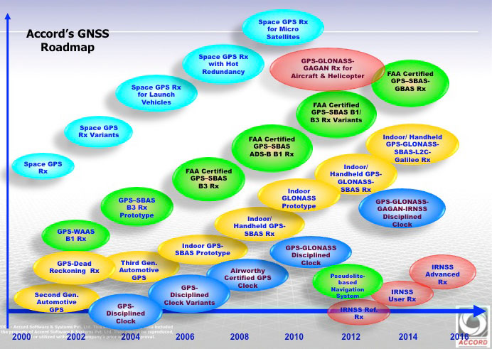
Accord GNSS roamap.
And as can be seen from the Accord GNSS Roadmap, they aren’t done yet!
You might ask yourself, where in the heck did all this come from? Certainly, there is an element of internal support with work for ISRO and Indian forces, but you don’t jump into this without some background. Well, the principle activity for Accord has been and still remains high-integrity software development for avionics systems — this is probably what Accord is known for in Europe and to a certain extent in North America. Its customer list for RTCA DO-178B/C airborne software sounds like a who’s who of aircraft and helicopter manufacturers — including Airbus, Boeing, Mitsubishi, Gulfstream Eurocopter/AugustaWestland/NHIndustries, Sikorsky, and Hindustan Aeronautics Limited (HAL).
Accord’s activities have included complete and partial life-cycle activities — all the way from requirements definition, software design and development, to independent verification and validation. For those of us who’ve worked in this field, we recognize that these are considerable technical capabilities — indeed, more than 50 engineers at Accord have been trained in the art of airborne software development by FAA-qualified engineering representatives. Working in this area and successfully bringing avionics systems through the qualification/certification process, companies either become capable or break all their bones trying! Clearly, Accord has been schooled in systems that are at the forefront of avionics technology, and has passed through the practical fire of qualifying airborne systems successfully.
So, it’s not really surprising that Accord went on to spin off into airborne GNSS receiver development once it gained wide visibility and knowledge of aviation technology and began to look at related markets. And with the Indian government policy of developing indigenous industries, Accord likely had some internal Indian customers. Quite a number of parallels with the way Europe has encouraged its own GNSS industry through the Galileo program.
With several avionics OEM manufacturers already using embedded NexNav TSO certified receivers in their systems using incorporating licensed designs, Accord looks well positioned to continue its airborne market growth. Accord’s success has so far been in general aviation, but it has wider aspirations, which include commercial transport aircraft (airline aircraft) — this is a segment which has the highest level of development/certification scrutiny and is therefore the most expensive segment in which to compete. Let’s hope Accord continues its growth and there is room in an expanding market for these relative newcomers.
Hexagon has announced it will offer NOK 28 in cash per share in positioning company Veripos in a public voluntary offer:
Hexagon will make a voluntary offer of NOK 28 in cash per share of Veripos, a company listed on the Oslo Stock Exchange
The voluntary offer represents a premium of 44 per cent to Veripos’ volume weighed average stock price during the three month period up to and including 11 October 2013
The offer will require acceptance from shareholders representing a minimum of 90 per cent of the Veripos share capital and voting rights, and certain other customary conditions for public voluntary offers
A five=week offer acceptance period will start shortly following the approval of an offer document by the Oslo Stock Exchange
According to the announcement, the Board of Directors of Hexagon AB has decided that Hexagon, directly or through a wholly owned subsidiary, will present to the shareholders of Veripos Inc., a voluntary offer of NOK 28 in cash per share for all outstanding shares of Veripos.
The offer price represents a premium of 21.7 per cent to the last traded price for Veripos of NOK 23, and a premium of 28.1 per cent, 43.6 per cent, 47.8 per cent and 46.3 per cent to the volume weighted average share prices (source: Bloomberg) for the one, three, six and twelve month periods, respectively, that ended on October 11.
On September 30, Hexagon contacted the Board of Directors of Veripos with a proposal of Hexagon making a voluntary offer of NOK 28 for all of the outstanding shares of Veripos, subject to due diligence and certain other conditions. On October 4, Veripos and Hexagon entered into a due diligence agreement where Hexagon was granted access to conduct a limited due diligence review on an exclusive basis. Such due diligence was concluded to Hexagon’s satisfaction on October 12.
Ola Rollén, President and Chief Executive Officer of Hexagon, said, “It is a good strategic fit between Hexagon and Veripos where Hexagon will provide, state of the art, positioning technology to Veripos as well as future growth via Hexagon’s onshore markets. Veripos has, in turn, built up a strong position in the offshore market and has world class infrastructure that Hexagon can leverage on immediately after an acquisition rather than building such infrastructure in-house.”
The offer will not be subject to any financing conditions. Hexagon’s preliminary assessment is that the offer will not be subject to any competition approval. The complete details of the offer, including all terms and conditions, will be contained in an offer document pursuant to chapter 6 of the Norwegian Securities Trading Act.
Hexagon has filed the offer document for review and approval with the Oslo Stock Exchange and the offer document will be sent to Veripos’ shareholders as soon as it has been approved. The acceptance period for the pffer will be five weeks from the date of the offer document being released, unless extended by Hexagon. The acceptance period may be extended, one or several times, provided however that the maximum acceptance period may not exceed 10 weeks.
As will be further detailed and specified in the offer document, the completion of the offer will be subject to the following conditions being satisfied or waived by Hexagon:
The offer has been accepted by shareholders representing more than 90 per cent on a fully diluted basis of the share capital and voting rights to which the offer relates;
Approvals from public authorities;
No material adverse change up until the settlement of the offer;
Conduct of business in the ordinary course and in accordance with applicable laws, regulations and decisions of any governmental body; and
Other customary conditions to be specified in the offer document.
While the offer will be subject to a completion condition of more than 90 per cent acceptance, Hexagon will retain its full right to amend or waive such condition, and hereunder also to make a compulsory acquisition of any remaining shares, subsequently to the offer, through the implementation of a so called “long-form merger” under the Cayman Company Act should the acceptance of the Offer be equivalent to more than two-thirds of the outstanding share capital and voting rights on a fully diluted basis.
The Offer will not be made in any jurisdiction in which the making of the Offer would not be in compliance with the laws of such jurisdiction. The Offer will be made to U.S. shareholders in Veripos. This notification does not in itself constitute an offer. The Offer will only be made on the basis of the Offer Document and can only be accepted pursuant to the terms of such document.
Averna, developer of test solutions and services for communications and electronics device-makers worldwide, today announced it has received a Broadband Technology Report (BTR) Diamond Technology Review ranking of 4 “Diamonds” for its DOCSIS Channel Emulator (DCE).
Now in its ninth year, the BTR Diamond Technology Reviews is a renowned industry program that was developed to recognize some of the top products and solutions available to the cable industry as determined by a distinguished panel of cable telecommunications engineering experts. Engineering executives from Boyer Broadband, Time Warner Cable, Bright House Networks, Suddenlink Communications, Comcast, Charter and Cox were among the third-party judges for the 2013 Diamonds. The judges had this to say about Averna’s DCE:
“A handy and cost-effective solution for equipment manufacturers to test and validate new DOCSIS products that use bonded channels. MSOs may also have an interest in the product for validating new modem modulation profiles or their own internal product validation efforts.”
“Improved DOCSIS performance testing capabilities, at lower cost and with smaller footprint, for equipment manufacturers and network operators.”
“A creative way to test DOCSIS networks.”
Averna’s DOCSIS Channel Emulator (DCE) is a small-footprint channel-emulation platform that helps device makers ensure that their DOCSIS and EuroDOCSIS products deliver optimum performance in the field. It is capable of acquiring, impairing and generating up to 24 downstream (DS) channels in real time.
The DCE’s flexible FPGA-based design is powered by National Instruments’ vector signal transceiver (VST), which enables Averna to increase the number of supported channels without increasing the DCE’s hardware footprint. The DCE helps users ensure that their equipment meets standards such as the SCTE 40 specifications or MSO-specific configurations. Furthermore, the DCE’s software-based approach and modular architecture protect the client’s investment, allowing them to easily cover both current and future test needs.
“We are proud to achieve such a high score in the Diamond Technology Reviews,” said Jean-Levy Beaudoin, VP Sales, West USA and Latin America, for Averna. “As the DOCSIS industry moves to high channel counts, the DOCSIS Channel Emulator is the first test instrument specifically developed for this new environment, enabling testing that was not economically and technically possible before. Broadband device makers can now increase test coverage and accelerate testing, improving product quality and time-to-market.”
Esri published an interactive map that allows viewers to explore the top 10 metropolitan areas that could be impacted by the government shutdown based on the percentage of wages that goes to federal employees, according to Trulia.com. Click here to experience the interactive map.
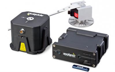
Applanix, a mobile mapping and positioning company, has introduced new versions of its positioning and orientation systems for airborne and land-based mapping — the POS AV 610 and POS LV 610. Delivering the same industry-leading performance as previous versions of POS AV and LV, the new systems use next-generation commercial inertial technologies that are offered globally.
Applanix POS AV and LV products integrate precision GNSS with advanced inertial technology (accelerometers and gyroscopes) to provide uninterrupted measurements of the position, roll, pitch and true heading of moving vehicles. Geospatial projects using POS can be completed more efficiently, effectively and economically. The POS AV 610 and POS LV 610 offer new advantages to customers:
Global availability: commercial technology.
Smaller and lighter: achieved by integrating a new state-of-the-art FOG (Fiber Optic Gyro) based Inertial Measurement Unit (IMU).
Exceptional performance with Applanix SmartCalTM software: SmartCal is a new compensation technology designed to achieve unrivalled performance from IMUs manufactured specifically for mobile mapping applications.
Cost efficiency: exceptional accuracy, even in demanding conditions, at unprecedented price points.
POS LV 610 and AV 610 are also available to systems integrators in the form of an OEM board set called the Trimble AP60. The Trimble AP is a series of embedded GNSS-Inertial OEM boards that provide both continuous mobile positioning in poor signal environments and high-accuracy direct georeferencing of imaging sensors. The AP series is ideal for a variety of commercial mobile positioning and orientation applications including airborne and terrestrial mapping and guidance for unmanned vehicles.
“The latest versions of POS LV and POS AV take Applanix’ state-of-the-art positioning technologies worldwide for land and air applications,” said Steve Woolven, President of Applanix. “Wherever mobile mappers operate, the new POS technology provides users with accurate, reliable and robust position and orientation solutions.”
POS AV 610, POS LV 610 and Trimble AP60 are available now through the Applanix sales network.
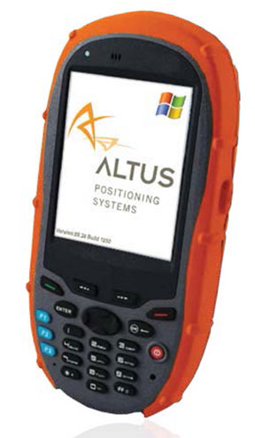
Altus Positioning Systems is expanding its line of GNSS surveying products with the introduction of the GIS-1, a versatile personal digital assistant (PDA) for data collection and geolocation.
The GIS-1 is a powerful PDA that integrates modern wireless technologies on a rugged Windows Mobile platform for effective portable computing for mobile survey applications. It can be used as a data collection device with Altus’ APS-series GNSS survey instruments, providing up to eight hours of operation time in the field between charges. In addition, the unit’s built-in L-1 GPS receiver and 3.2 megapixel camera can be used for navigation and GIS applications. It can even be used as a smartphone.
“The GIS-1 is a versatile tool for surveyors and GIS professionals,” said Neil Vancans, president of Altus Positioning Systems. “With the Windows Mobile operating system, it supports a wide range of software applications for data collection. By itself, the GIS-1 is a convenient low-cost GPS navigation device with 2.5-meter accuracy.”
“It’s ideal for GIS work,” Vancans added. “The user can quickly and easily locate assets with 2.5-meter accuracy with the GIS-1, then switch to the APS-3 for more precise RTK work if needed.”
The GIS-1 supports a wide range of wireless options, including Wi-Fi, Bluetooth and a Tri-Band GSM/GPRS/EDGE/HSPA cellular modem.
According to a new research report from the analyst firm Berg Insight, the number of active fleet management systems deployed in commercial vehicle fleets in Europe was 3.05 million in Q4-2012. Growing at a compound annual growth rate (CAGR) of 16.0 percent, this number is expected to reach 6.40 million by 2017. A group of international aftermarket solution providers have emerged as the leaders on the European fleet management market. Masternaut is ranked as the largest player overall in terms of installed base with close to 287,000 units deployed today. TomTom Business Solutions was the fastest growing vendor also in the past year and has now surpassed 275,000 subscribers in this region. Digicore and Trimble have also joined the exclusive group of fleet management providers in Europe having more than 100,000 active devices in the field. Transics is number one in the heavy trucks segment with an estimated 80,000 active units installed.
A major trend in the past two years has been the announcements of standard line fitment of fleet management solutions. Since the end of 2011, Scania is rolling out the Scania Communicator as standard on all European markets and includes a four-year basic service subscription. The new generation of the Actros trucks from Mercedes-Benz contains the FleetBoard vehicle computer as standard in all EU27 countries since October 2011. Volvo is going in the same direction offering Dynafleet as standard in Europe. MAN TeleMatics is since July 2012 standard on the new truck model TGX EfficientLine.
A second wave of M&A activities started in 2013 after 18 months of lull. “Six major mergers and acquisitions have so far taken place this year among the vendors of fleet management systems in Europe”, said Johan Fagerberg, Senior Analyst, Berg Insight. Danaher Corporation is betting on the fleet management market and acquired Navman Wireless and Trafficmaster from Prairie Capital and Vector Capital respectively. TomTom made its second acquision in the fleet management space when picking up Coordina headquartered in Spain. The latest transaction was done in September 2013 when Oskando and Autolog merged and at the same time launched the new brand EcoFleet. Mr. Fagerberg anticipates that the market consolidation of the still overcrowded industry will continue in 2014.