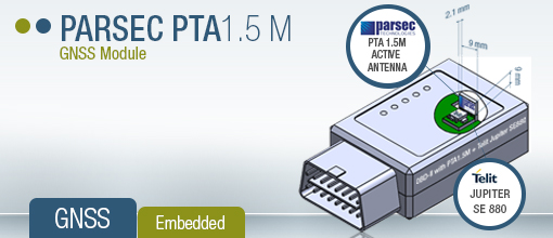
The Parsec PTA and PT active and passive antenna modules integrate seamlessly with the Telit Jupiter SE880 GPS receiver for market leading location aware applications in performance and miniaturization.
The PTA/PT family delivers best-in-class linearity in the third-order-intercept point (IP3), the measure of a receiver’s critical ability to differentiate signal from noise. All PTA and PT antenna modules are based on Parsec’s family of low noise amplifier (LNA) integrated circuits (ICs).
The antennas are designed for embedded LBS receivers requiring good user experience that operate with obstructed view of orbiting satellites. The PTA1.5M improves GNSS receiver sensitivity to offset high path loss, improves immunity to receiver descending caused by close proximity radio transceivers, and mitigate the effects of interference from radio mixing products.
DirectMail.com will launch GeoInsight, the firm’s advanced marketing intelligence and data sourcing tool, at DMA 2013. DirectMail.com will demonstrate GeoInsight’s capabilities at the Direct Marketing Association conference in Chicago on October 13–15.
According to DirectMail.com, GeoInsight puts powerful, easy-to-use database analytics capabilities into marketers’ hands. Based on a web-based map interface, GeoInsight provides the following functionality:
The combined power of enterprise-level, location-based data analytics and real-time, customer-rich profile information,
Instant analysis of markets, customers and prospects, yielding visual and quantitative displays of geographic concentrations and lifestyle and purchasing characteristics, and
A new level of selectivity and precision in targeting prospects and engaging existing customers by combining a marketer’s existing database with GeoInsight’s location-based, data-mining and modeling information.
The GeoInsight tool features enhancements such as:
A data visualization engine that allows customized reporting based on relevant data points,
Thematic map overlays, using either client data or enhanced consumer data,
Access to digital behavior insights, enabling better cross-channel marketing and timing,
Targeted segmentation and messaging strategy models, and
Analysis of client files based on customer transactional or summarized data.
“DMA 2013, the global event for data-driven marketers, is the ideal venue for launching GeoInsight,” said Joe Leger, vice president of Data and Analytics, DirectMail.com. “Marketers who understand data’s power to transform a brand and a business will be amazed by how this innovative marketing intelligence and data sourcing tool brings a whole new level of selectivity and precision to the task of targeting prospects and engaging current customers. With GeoInsight’s revelations about customer behaviors and lifestyles, their ability to increase market share — and do so with greater return on marketing investment — will be facilitated.”
ORBCOMM Inc., and Savi Technology have announced a strategic relationship to provide advanced location-based monitoring solutions to government and commercial markets.
ORBCOMM is a global provider of machine-to-machine (M2M) solutions, and Savi Technology is a provider of sensor-based analytics and radio-frequency identification (RFID) solutions.
ORBCOMM and Savi have submitted a proposal in response to the U.S. Army RFID IV project, which will provide both ISO18000-7 RFID tags and a suite of satellite solutions for military logistics support. ORBCOMM’s GlobalTrak division has been a leading player in providing military Enhanced-In-Transit-Visibility (EITV) solutions to the government market since 2008, and Savi has been a market leader in military RFID solutions, enabling it to offer vast market experience with the right blend of technology platforms for this proposal.
“The combination of ORBCOMM’s satellite expertise and broad network service portfolio with Savi’s state-of-the-art RFID technology offers a full spectrum of innovative monitoring solutions to our collective market base with focus on our government and international customers,” said Marc Eisenberg, Chief Executive Officer of ORBCOMM. “Although RFID and satellite tracking have traditionally been divergent technologies, the synergy of these solutions within a common operating environment creates a seamless transition from infrastructure to wireless-based location services for tracking and monitoring high-value assets.”
“By bringing two market leaders with highly complementary technologies together, we have created a best-of-breed solution for our customers in both government and commercial markets,” said Bill Clark, chief executive officer of Savi Technology. “This relationship will support Savi’s operational analytics capabilities by providing additional ways to collect critical data and deliver timely and reliable operational intelligence to our customers. We look forward to partnering with ORBCOMM on RFID IV and other global opportunities in the near future.”
Parsec Technologies, Inc., today announced that the company’s Micro-Mini PTA/PT family of GNSS/GPS receiver modules seamlessly integrates with the Telit Wireless Solutions Jupiter SE880 three-dimensional system-in-a-package (3D-SIP) to enable what it calls the world’s smallest- to-date, commercial-class, low-cost GPS L1 receiver.
By combining a PTA/PT family module with the Jupiter SE880 3D-SIP, OEMs and integrators are able to deliver a location-based service product with a GPS L1 receiver in a landed form factor of 20 x 20 x 6 millimenters, or 20 x 10 x 6 millimeters, depending upon component orientation. This contrasts with landed GPS receiver sizes integrating a passive ceramic patch antenna that measure 25 x 25 millimeters, and which Parsec says don’t match the GNSS/GPS frequencies in performance despite being four times the surface area.
With the Parsec/Jupiter combination, integrators can design LBS-critical products with exceptional user experience in applications with severe use, such as obstructed satellite view and high path loss, including indoors, urban canyons, wearables, smart watches, vehicle under-dash on board diagnostics (OBD) devices, metal containers and aircraft fuselage asset tracking, and M.2/next-generation form factor (NGFF) products.
Receivers combining Parsec PTA/PT Family and Telit Jupiter SE880 modules deliver good user experience in finished LBS critical products without sacrificing design flexibility, ease of implementation, or cost, Parsec said. The combination is fully vetted and “bulletproof” in providing a rewarding design experience making RF work reliably, passing end-product regulatory compliance testing without re-test.
According to Michael A. Neenan, CEO and founder of Parsec, customers are future-proofing their LBS critical products when they select a Parsec PTA/PT family for integration with the Telit Jupiter SE880 3D-SIP. PTA/PT family modules receive and amplify any GNSS system signal from 1560 to 1610 MHz, including GPS L1/L1C, with high radiated efficiency in any end product orientation.
Telit Jupiter SE880 reference design kits will soon be equipped with the Parsec PTA/PT family module. OEMs and integrators can order GPS L1 receiver solutions today.
The PTA/PT family of GNSS/GPS receiver Micro-Mini modules extends Parsec’s decade-long tradition of stretching the state-of-the-art in small size, ultra-linearity, miniscule energy usage, high gain, low noise, Any Voltage operation, Field-and-Forget reliability, low cost, and ease of integration/use.
XRS Corporation, a mobile trucking intelligence company, has announced that Verizon is the official wireless provider for its new collaboration with Samsung Telecommunications America. The new product — NXT — creates what XRS says is the first integrated mobile device and software package designed specifically for the trucking industry.
The new solution brings together powerful XRS compliance and performance tools with Samsung Mobile’s devices, XRS said. Now, NXT is powered by the Verizon 4G LTE network, which provides the platform with superior performance and speed.
“Technology forces in the trucking industry have long been on converging paths, and our new NXT product — powered by XRS in collaboration with Verizon and Samsung Mobile – is a perfect example of how our industry is harnessing the power of technology to benefit drivers and fleet managers,” said Christian Schenk, senior vice president, XRS Corporation. “An integrated platform is the next evolution of convergence, and we are proud to be working with industry leaders like Samsung Mobile and Verizon to deliver the ultimate trucking intelligence solution.”
NXT allows drivers and fleets to purchase select Samsung Mobile devices with an XRS trucking intelligence software subscription and ready for activation on the Verizon 4G LTE network. The first device available is the Samsung Galaxy Tab 7.0, priced at a $100 discount from its suggested retail value. The data plan and subscription cost is $54 per month, including $39 for the monthly XRS fee and $15 for the monthly wireless data fee. This charge covers all required subscriptions and data, including the Relay onboard hardware component, as well as FLX messaging, hours of service, electronic DVIR, IFTA state mileage reporting and more.
“With the explosive growth of mobile electronic devices in the trucking industry, drivers have come to expect reliable and fast wireless service while they are on the road,” said Michael Toto, director of alternate channels for Verizon Enterprise Solutions. “This solution is one example of how Verizon is investing in the success of our channel partners as we collaborate to bring new innovative solutions to the market.”
NXT also offers integration with many enterprise transportation products. Over time, the platform collaboration will expand to introduce additional components, including MDM and wearable products.
The XRS trucking intelligence platform operates in both over-the-road and private carrier configurations, and is suitable for fleets of all sizes. XRS runs on certified smartphones, tablets and rugged handhelds that transmit vehicle and operator data through the cloud to a fleet management dashboard, helping companies to comply with current regulations and soon the pending Electronic Logging Device (ELD) mandate for electronic recording of a driver’s hours-of-service. Nearly 90 percent of drivers already use mobile devices while on the job.
NXT was developed through the Samsung Solutions Exchange, a newly announced strategic engagement model from Samsung Mobile that delivers a range of end-to-end solutions that address real world business challenges. The program is aimed at achieving shared value across Samsung Mobile’s rapidly growing ecosystem of enterprise customers, sales channels and alliances.
“NXT is a holistic solution for trucking that addresses performance, safety, and compliance challenges unique to the industry,” said Tim Wagner, vice president and general manager, enterprise business unit – Samsung Mobile. “Through the Samsung Solutions Exchange, we have worked closely with XRS and Verizon to enable a solution that leverages our respective strengths – which for us includes our robust suite of enterprise-grade devices.”
Customers can buy the NXT product either directly through Verizon or through XRS.
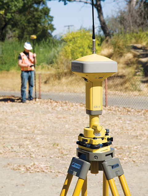
Topcon Positioning Group has released the GR-5 receiver with Vanguard technology, designed to optimize tracking and performance.
“The GR-5 is a next-generation GNSS receiver, built on multi-constellation integrated technology pioneered by Topcon,” said Scott Langbein, director of product marketing.
“Now with the inclusion of Topcon’s exclusive 226-channel Vanguard technology with Universal Tracking, and the power of full-wave Fence Antenna technology that provides multipath rejection in difficult environment, the GR-5 operates with unsurpassed sensitivity, tracking accuracy and performance.”
In addition to Universal Tracking, Vanguard technology includes Quartz Lock Loop for signal processing in heavy vibration applications and Intelligent Tracking Optimization to select the best combination of available satellite signals.
“At any time, end-users can track all available satellite signals and be assured of getting accurate measurements regardless of environmental conditions,” Langbein said.
Additional features of the GR-5 include:
Cellular and radio: The GR-5 has both cellular and radio communications, which allows it to be used in radio-based RTK and network RTK systems;
Long-range UHF radio: The top-mounted radio antenna extends the range of RTK radio performance;
Operating time: GR-5 hot-swappable batteries are designed for full-day operation;
MAGNET Field: MAGNET Field software can be used with the GR-5 RTK system, providing the ability to share data to cloud storage and connect field crews to each other and the office.
According to a new report by Research and Markets, the winners in making and operating mobile phones will offer the most compelling new functionality, IPS being a major enabler. The winners in making, integrating and operating RTLS will reduce cost and improve usefulness, not least to encompass mobile phones and other mobile computing. The world’s largest companies are locking horns on this.
The term Indoor Positioning Systems (IPS) primarily concerns location-based services on mobile phones where GPS does not work. The term Real Time Locating Systems (RTLS) primarily concerns locating people and things at a distance, securely, using second generation RFID. The subjects are converging with Apple, Samsung, Google, Nokia, Microsoft, Hewlett Packard and IBM clashing for the tens of billions of dollars of business that is emerging.
This subject heavily involves short range communications, notably Wi-Fi and Bluetooth, and inertial navigation and advanced RFID as it progresses to determining 3D position including orientation and line of travel. Emergency services, healthcare, retailing, manufacturing, logistics and many other industries will be transformed by what is becoming possible, Research and Markets said.
The topics of IPS and RTLS embrace a value chain from research and consultancy to software, services, hardware, integration and facilities management. Mobile phone app developers and value added enhancements plus ecosystems of mobile phones, web services and more are also involved.
Most of the development and use is in the USA, but other territories are racing to catch up. For example, the new Indoor Location Alliance came from Europe but has global players and companies, such as Samsung in East Asia, and is taking an exceptionally broad view from new phone design to RTLS in smart cities. Siemens in Europe and several Japanese and U.S. companies seamlessly integrate GPS outdoor navigation and services with IPS and RTLS.
This report consists entirely of evidence-based analysis following seven years of conferences, masterclasses and reports on the subject produced by the PhD level IDTechEx analysts and team.
The main features of the report, which is continuously updated, are the following:
Ten year forecast of the RTLS market 2014-2024, platform hardware vs system integration/services.
Full explanation of what IPS and RTLS are and how these technologies are evolving and converging, with detailed, original graphs and diagrams, largest orders landed and lessons arising. Threats, opportunities and company strategies are revealed.
Comparison of 105 organisations in the IPS/ RTLS value chain by country, basic measuring principle, standards, frequencies, protocol, range, accuracy, applications targeted and background information. Pie charts and graphs give analysis by parameter.
Comparison of 74 case studies of RTLS with many pie charts presenting the lessons arising.
Detailed original interviews carried out from mid 2013 with important organisations in this space.
Glossary of the challenging jargon, which is different between IPS and RTLS yet often refers to the same or similar things.
Spectra Precision introduced at Intergeo this week new and updated products to expand its portfolio of solutions addressing the needs of the mainstream surveying and construction markets. Intergeo 2013 is a geodesy, geoinformatics and land management trade event being held in Essen, Germany.
“Earlier this year, we introduced a new reflectorless entry-level total station, the lightweight ProMark 700 RTK Network Rover and the Layout Pro construction layout software suite. With our latest additions, the Spectra Precision portfolio continues to evolve to meet the changing needs of our users,” said François Erceau, general manager of Spectra Precision’s GeoInstruments Business Unit. “Spectra Precision now offers one of the broadest and most complete portfolios of survey and construction products in the industry — from construction lasers and total stations to survey GNSS receivers and GIS handhelds — all from a single supplier that customers can trust.”
New and updated Spectra Precision products include:
Spectra Precision EPOCH 50 firmware 4.81 –now supports RTK positioning using the Chinese BeiDou open service GNSS satellite signals. Adding the BeiDou constellation to the full range of GPS and GLONASS signals already tracked by EPOCH 50 further boosts the capabilities of this GNSS receiver to enable faster initialization and performance, even in conditions where satellite visibility is obstructed due to tree canopy or tall buildings.
MobileMapper 120 Decimeter Edition –this new kit, based on the MobileMapper 120 handheld GNSS receiver, includes the Flying RTK, GLONASS tracking and NTRIP correction options. With accuracy of 20cm or better, the Decimeter Edition kit is a competitively priced solution for precise Mobile Mapping applications.
ProFlex 800 firmware version 1.9 – now supportsGLONASS-only mode and tracking of QZSS signals to meet the needs of specific markets (Russia and Japan, respectively). This updated firmware also improves RTK performance in VRS networks, particularly in challenging GNSS environments, through Z-Blade technology enhancements.
Layout Pro Field and Office software – a recent release of the Layout Pro field software added support for the FOCUS 30 Robotic Total Station, offering the highest level of productivity and accuracy in a construction layout solution. The Layout Pro version 2.1.1 update now includes language packs for major markets worldwide, in addition to many other minor enhancements. Customers with a current Layout Pro maintenance agreement are eligible to download this update from www.spectraprecision.com.
Survey Basic software for total stations – further enhancements to this entry-level software application make for the simplest starting point, with workflows that mirror the familiar Nikon-style FOCUS 6 user interface in a modern full-color touch-screen instrument (FOCUS 8). Further language packs have been added, including Czech, Traditional Chinese, Korean and Polish.
Survey Pro Field software version 5.4 – the latest release of this award-winning survey field software includes many new features and enhancements such as:
Updated Digital Terrain Model (DTM) features and interface
Support for new GNSS constellations and an improved GNSS workflow
Additional Active Map enhancements that make it easier than ever to work directly from the map screen
Updated point staking routines and a new interface for building design point lists
A new Plane and Vertical Angle Offset routine
A new electronic compass display in various map screens
Enhanced total station and GNSS setup routines
An improved Code/Description entry and display system
Customers with a current Survey Pro maintenance agreement are eligible for this update and can download the software from .
Spectra Precision Survey Office software v3.10 and v2.95 – both versions are companions to Survey Pro 5.4 field software and FAST Survey field software, and offer enhanced baseline processing with more reliable outlier detection and improved accuracy statistics. Additionally, version 3.10 features a new customized ribbon UI and is optimized for 64-bit PCs (with notably faster processing).
These new and updated Spectra Precision products are now available for order through the Spectra Precision global reseller network.
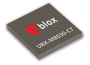
u‑blox has announced the launch of its newest core positioning platform, the u-blox M8. The new chip forms the basis of u-blox’ upcoming line of positioning modules, which are able to acquire and track different satellite systems concurrently to achieve higher accuracy and reliability.
Supporting all deployed as well as upcoming GNSSs, the platform is based on the UBX-M8030 concurrent multi-GNSS receiver IC which is able to track American GPS, European Galileo, Japanese QZSS, Russian GLONASS, and Chinese BeiDou satellites.
Concurrent tracking of GPS (QZSS) and GLONASS or BeiDou, or concurrent tracking of GLONASS and BeiDou satellites increases performance for applications requiring maximum availability and accuracy. The chip is prepared for the European Galileo system through a future firmware upgrade once the constellation is fully available.
The new platform will ultimately support special functions such as Automotive Dead Reckoning and precision timing to support a wide variety of vehicle, industrial and consumer applications.
To further improve acquisition performance, u-blox’ globally available “AssistNow”assisted-GNSS service for accelerated positioning has been extended for u-blox M8 products; the service supports both GPS and GLONASS, and the validity of downloaded assistance data is now able to support offline operation for up to 35 days.
“With the proliferation of multiple new GNSS systems beyond GPS, our u-blox M8 platform is designed to take full advantage of the increasing number of visible satellites to further increase accuracy and availability, particularly in urban and vehicle-based applications,” said Daniel Ammann, executive vice president, head of the Positioning Product Centre, and co-founder of u-blox, “At the same time we realize the ongoing requirement for extremely low-power and cost-sensitive portable applications where operation with a single GNSS system is more than sufficient. That is why we will continue to offer both u-blox M8 and u-blox 7 based products to the market.
The new u-blox M8 chip is at the heart of u-blox’ next generation of positioning modules based on the company’s popular MAX, NEO and LEA module form factors.
u-blox M8 chips feature low power consumption in concurrent reception mode, thanks to an innovative single-die architecture combined with sophisticated software algorithms. The extended supply voltage supply range and 1.8 V/3.0 V I/O compliance supports a wide variety of system architectures. Sophisticated radio architecture and interference suppression using active jamming detection ensure maximum performance even in GNSS hostile environments. UBX-M8030 chips are available in miniature WL-CSP (2.99 x 3.21 x 0.36 mm) and QFN (5.00 x 5.00 x 0.59 mm) packages. The chip is also available in automotive quality grade according to AEC-Q100.
The new platform maintains backwards compatibility with u-blox 7 modules and QFP chip products which remain in the company’s portfolio as the industry’s lowest power standalone satellite positioning receivers. u‑blox’ capability of delivering GNSS technology in both integrated circuit and form-factor consistent modules provides maximum design flexibility and protects customers’ development investments over successive product generations.
First samples of the multi-GNSS receiver chip UBX-M8030 are available for customer evaluation. Soon, module customers can easily migrate to the MAX, NEO, and LEA form factors, u-blox’ popular, industry-standard module form factors.
Leica Geosystems Inc. today announced that Tuck Mapping Solutions Inc. has completed the first integration of a Leica RCD30 airborne camera with the Applanix POSTrack system. With technical support from Leica Geosystems and Applanix, Tuck Mapping contracted Lead’Air Inc. of Kissimmee, Florida, to perform most of the software upgrades and new cabling required to integrate the Leica digital camera with the POSTrack all-in-one GNSS-aided inertial direct georeferencing and flight management system.
The Leica RCD30 is a true metric camera built for mapping. Introduced by Leica Geosystems as a digital follow-on to its RC30 film cameras, the RCD30 is a medium-format digital imaging system developed for a variety of photogrammetric and remote sensing applications. The 60 MP single-camera-head design delivers co-registered, multispectral imagery in the Red, Green, Blue and Near IR portions of the spectrum. The sleek modular design allows the camera to fit easily in aircraft previously outfitted with film cameras, and the RCD30 integrates with many LiDAR sensors, including the Leica ALS series.
For the many current owners of the POSTrack system, the availability of integration by Lead’Air makes the Leica RCD30 a more affordable and attractive choice among medium-format digital cameras. When buying a new Leica RCD30, POSTrack owners do not have to purchase the Leica flight management system, train flight crews in the use of multiple interfaces, and install redundant equipment in their aircraft.
“The integrated systems enable our flight crews to operate the Leica RCD30 and a third-party LiDAR sensor with a single flight management interface,” said Tuck Mapping President, Bobby Tuck. “In addition, POSTrack collects the GNSS location and Inertial Measurement Unit (IMU) attitude data needed to georeference the imagery and LiDAR data sets.”
Based in Big Stone Gap, Virginia, Tuck Mapping is a photogrammetric services and aerial mapping firm with a reputation for engineering innovative solutions related to geospatial data collection. Tuck was among the first aerial mappers to use a helicopter for LiDAR scanning operations, and more than a decade ago the firm took the lead in successfully integrating an airborne camera and LiDAR sensor for simultaneous collection. Tuck Mapping owns four POSTrack systems, three helicopters, two fixed-wing airplanes, and state-of-the-art airborne cameras and laser scanners.
“Bobby Tuck deserves credit for driving the integration of the Leica RCD30 with the POSTrack system,” said Jean Gardiner, General Manager of Leica Geospatial Solutions. “From a business perspective, Leica believes that supporting the compatibility of our products with other manufacturers’ products is an integral part of providing solutions to our clients.”
“This joint integration project exemplifies the maturity of Leica and Applanix,” said Joe Hutton, Applanix Director of Inertial Technology and Airborne Products. “It’s a natural progression of good customer support.”
Jointly developed by Applanix and Track’Air, the POSTrack product integrates the Applanix POS AV direct georeferencing technology, utilizing GNSS and IMU components, with the XTRACK Flight Management System software from Track’Air into a single, compact package. POSTrack provides direct georeferencing for airborne mapping sensors, mission planning, real-time sensor control and pilot guidance.
Lead’Air, a subsidiary of Track’Air, specializes in integrating the Track’Air flight management systems with any airborne camera or LiDAR sensor. Now that the first Leica RCD30/POSTrack integration has been completed for Tuck Mapping, Lead’Air offers this integration as a commercially available service.
Many may consider it a distinction without a difference, but quality matters, whether it concerns a life-changing decision or something as simple as which conference to attend. When resources are scarce, making the right decision, or sometimes just making any decision, matters — for many in our government this paradigm should reign supreme.
Over the past 24 months, it seems there have been more conferences and symposia that depend on government attendees cancelled or postponed than there have been quality events to attend. Politics aside, the U.S. government’s fiscal woes, which include sequestration and the latest partial U.S. government shutdown, are merely endemic of a much greater problem. Decision makers are unable to make decisions, negotiate or even consider compromise, and the last time I checked, decisions, indeed quality decisions, are critical to the success of any endeavor, be it government or business.
More than 2500 years ago, Pythagoras (yes the Pythagorean Theorem mathematician) said “Choices are the hinges of destiny,” and make no mistake about it, the decision to not make a decision or the inability to act is still in the end a decision, just not an action or non-action of which one should be proud. And this inability to make a decision still affects your destiny today or our destiny where Congress is concerned. William James may have been thinking about the U.S. Congress when he said, “When you have to make a choice and don’t make it, that in itself is a choice.” Actually, my secretary summed it up nicely, extolling her frustration with our do-nothing Congress, “…in the end if I conducted myself as your employee the way Congress has conducted their affairs for the last 24 months, I would no longer be in your employ. You would have fired me long ago.”
Fortunately, for the rest of the world, there are people who seem capable of making momentous decisions on a daily basis — imagine that. And despite what the entrenched U.S. Congress doesn’t decide, the world does go on, even as the somnolent U.S. government shuts down and irrationally decides not to allow government employees and the military to attend critical conferences or symposia. Since Congress can’t do anything, it appears they want to mandate that everyone else emulate their indecisiveness. Despite the governmental ennui, there are some bright spots. In the last two months I had the pleasure of attending two separate conferences concerning GIS, GPS, GNSS, and PNT respectively that I highly recommend for your consideration. As I said earlier, quality matters, and both of these conferences have quality in abundance, especially in the areas of planning, presentations, location and attendees.
GeoGathering
As the comfortable, casual name implies, GeoGathering 2013 was more of a gathering than a full-blown mega conference, but then, that is also what sets this event apart. Especially from the National Space Symposium, which also takes place in Colorado Springs at a major resort but which draws more than 10,000 participants.
GeoGathering 2013 managed to gather ~150 GIS participants from around the globe, and in its own way was just as informational as many larger events. The four-star venue was outstanding, as the Cheyenne Mountain Resort has always been a laid-back location with restaurants and ambiance almost second to none. GeoGathering played out comfortably, with little stress, over two days, 21-22 August, during which the Rocky Mountain weather graciously cooperated.
The event was subtitled “GIS for Gathering and Production Lines,” which simply means it was primarily about gathering and using GIS data and meta-data successfully in a business environment. If that sounds a bit dry, in actuality it was a wonderful conference, since the prime ingredient for any successful conference is the people and the venue. Both were outstanding. The networking time between speakers and panels made for a very productive two days. I highly recommend this conference for those interested in anything to do with GIS (geographical information systems). GeoGathering 2015 will be held somewhere in Colorado, and right now you can influence that decision by going to the GeoGathering website and voting on a location. See you there.
ION GNSS 2013
Institute of Navigation Global Navigation Satellite System Symposium
The first question I typically hear when I mention the acronym GNSS in a non-PNT-oriented crowd is “What is GNSS?” GNSS stands for Global Navigation Satellite System(s), and is the standard generic term for satellite navigation systems that provide autonomous geospatial positioning, and sometimes time and frequency data, with global and/or regional coverage. This oft-used term has expanded to include GPS, GLONASS, Galileo, BeiDou and other regional or global PNT systems. And for me, there is no better global technical GNSS event than the annual ION GNSS symposium. For the last two years, with an attendance figure of about 1,000 per year, this seminal event has been held in Nashville, Tennessee. Next year and the following year, ION GNSS moves to Tampa, Florida, the home of our elite military special forces.
If you would like the bottom line up front, several years ago I penned a review of the ION GNSS event and it went something like this: “The ION GNSS Symposium is simply the best international technical symposium on GNSS that exist today, bar none.” Frankly, my opinion has not changed. The GNSS symposium has not changed in quality, even though the U.S. military participation has dwindled significantly due to circumstances detailed earlier in this column, but in many ways the symposium continues to improve.
The venue for the last two years was the Nashville Convention Center in Nashville, Tennessee — or Music City, as those of us in the U.S. know it — and it was a great location. This year, there were also FOUO sessions, which were extremely interesting, but because of the classification, I cannot say much more in this medium. The FOUO sessions were essentially a hold-over from the ION Joint Navigation Conference (JNC) event that was canceled earlier in the year due to the last-minute lack of participation by government participants. However, Lisa Beaty, the executive director for ION, assured me that the JNC 2014 event will take place come h*** or high water.
The new ION Military Division, which is headed by my long-time friend and colleague Jim Doherty (USCG, Ret), a former president of ION, now sponsors the Joint Navigation Conference, which is billed as the largest U.S. military navigation conference with joint service and government participation. The event focuses on technical advances in guidance, navigation, and control (GN&C) with emphasis on joint development, test and support of affordable GN&C systems, logistics and integration.
ION describes the JNC event as a conference that includes technical exhibits that showcase guidance, navigation and control technology products and services as well as operational products and demonstrations. With a decidedly operational perspective, the conference focuses on advances in battlefield applications of GPS, critical strengths or weaknesses of fielded navigation devices, warfighter PNT requirements and solutions, and navigation warfare.
As I mentioned, JNC is the annual ION event that normally features the FOUO U.S.-only presentations. Next year, ION JNC conference attendance June 16-18, 2014, is controlled by the Joint Navigation Warfare Center (JNWC) and is restricted to U.S. citizens only. The classified sessions on June 19, which typically feature a warfighter panel, which I have had the honor to help populate for the last several years, will feature 4-eyes access for citizens of the U.S.A., Australia, Canada and the United Kingdom. All participants must establish a need to know and be approved by the Joint Navigation Warfare Center security office. The 2014 Joint Navigation Conference takes place at the Renaissance Orlando at SeaWord in Orlando, Florida.
But that is JNC next year and I digress, so let’s get back to this years ION GNSS symposium. The amazing feature of this event is that you can literally attend a presentation on any aspect of GPS/PNT that you can name. For example, I wanted to attend specific presentations on: GPS time, PNT frequency stability, PNT atomic reference systems, L2C, L5, AEP, OCX, L1C, M2PS, and M-code, as well as jamming and spoofing mitigations. The problem, of course, is that there are numerous presentations on these topics, and many of them occur simultaneously. You have to carefully plan your time, and I frequently found myself, along with many others, sprinting from presentation to presentation. I did not want to miss anything, and I can truthfully say there are very few conferences where this is the case. The ION Papers Committee does a great job screening the papers and making sure they are relevant.
Plus, one of the best perks of being an official ION member is that, in case you miss a presentation, the symposia papers are all available online at the ION site within just a few days of the event.
Don Jewell visits the Exelis table at the GPS World Leadership Dinner.
Galas and Awards
The after-hours highlight of the ION GNSS event every year is the GPS World Leadership Dinner or gala, which includes the GNSS Leadership Awards. Only 150 guests may attend, by invitation only, because there are typically more than 1,000 attendees at ION GNSS. This has become one of the “must-attend” events. This year, both Exelis and Lockheed Martin sponsored the dinner along with GPS World, and we are grateful for their sponsorship. Each GPS World editor nominates 10 guests, so be nice to your favorite editor this year and, who knows, maybe you will be among the elite next year (hint, hint)!
The GPS World 2013 Leadership Awards.
This year, as last, the gala was held in the sumptuous ballroom of the Hermitage Hotel in Nashville, which was built in 1910, exudes Southern charm, and is dedicated to General and President Andrew Jackson, a true son of the South. Harking back to our earlier theme concerning decision-making, President and General Andrew Jackson made many difficult decisions in his tenure and one of his greatest quotes certainly applies:
“Any man worth his salt will stick up for what he believes right, but it takes a slightly better man to acknowledge instantly and without reservation that he is in error.” — Andrew Jackson
And if you can’t quite remember your history, just pull out a $20 bill and there he is.
The food and camaraderie were outstanding as usual. The evening’s entertainment, which is always provided in the form of an original Alan Cameron game that has dinner guests participating in a novel event, this year was based on a clandestine “spoofer” at each table that had to be identified by Q&A only. It was a fine and fun evening, and for the award winners, it was a special evening. Four awards were given this year, to Satoshi Kogure, Attila Komjathy, Peter Grognard and my good friend Per Enge from Stanford. Congratulations to all the award winners — you never know, you could be a guest or an award winner next year. (A full report on this year’s dinner and awards will appear in the December issue of GPS World.)
ION Kepler Award
ION GNSS also presents prestigious awards at this event. This year, the coveted Kepler Award went to a good friend and colleague Dr. John Betz.
Dr. John Betz, winner of the ION 2013 Kepler Award.
Now, the ION GNSS awards committee keeps the name of the award winner totally secret, in a mayonnaise jar on Funk and Wagnall’s front porch. No wait, that’s another award, but they do keep it a closely held secret — so close, in fact, that this year’s award winner’s wife was not in attendance, even though she made the trip with him. So, while I had no idea who would win, I did happen to be sitting at Dr. John Betz’s table, right across from him, when the hints were announced by Dr. Jade Morton, the ION Satellite Division Chair and therefore also the luncheon and award master of ceremonies.
You see, there is a long-held presentation tradition associated with this award. No one knows who has won the award, but the announcement is not just blurted out. Rather, there are about ten hints given about the identity of the person. As the identify of the winner becomes apparent to those in the room, they are asked to stand up, signifying they have determined the identity of the award winner. It was clear to me who had won with the first hint, and of course it was clear to Dr. Betz as well. It was very interesting to watch his facial expression as he realized he had finally won. It dawned on him, and then there was a slight smile, but at the same time a very humble expression.
Dr. John Betz, a MITRE and ION Fellow, certainly deserves this award, and indeed, has deserved it for some time, so it was great to see his considerable accomplishments recognized. And, BTW, remember that you heard it here first: John is working on a book about GNSS that should be published in the next six months. It is not an edited volume, but rather an original work by Dr. Betz, and I for one can’t wait to read it. You can bet I will review it here at GPS World. Congratulations, John.
The other outstanding features of ION GNSS are the excellent and numerous exhibits, plus the time allowed between sessions that provide an excellent atmosphere for networking. And the excellent Nashville Renaissance Hotel, which is attached to the Nashville Conference Center, provided numerous quiet and semi-secluded locations for extemporaneous meetings and is a networking friendly location. The restaurants were excellent, as was the ubiquitous Starbucks barista-manned coffee shop located in the hotel. In other words, Lisa Beaty and her team always manage to choose an event location with accommodations and amenities perfect for this event. I am looking forward to next year in Tampa. Hope to see you there.
What Is Don Reading?
Both books reviewed this month came to my attention because, contrary to the old adage, I was able to tell a good book by its cover.
Phantom, by John Bell.
Phantom An Adventure Novel by Ted Bell
This is a singular novel, frighteningly prophetic in many respects and virtually unprecedented in the multitudinousgrappling-hook approach employed to entice the reader. This is not a criticism, merely an observation, as I obviously thoroughly enjoyed the yarn.
Many novelists “set the hook” by using the old standby, “It was a dark and stormy night…the wind howled, lightning flashed.” Many novelists hook you with rollicking train stories, or Romanoff tales of excruciatingly frigid White Russian winters with Tsars, Tsarinas and Tsarvitches. They hook you with stories of beautiful bounding yachts or fancy racing cars. Or, in the late Tom Clancy style, they hook you with stories of Air Force One and the president versus terrorists, or of course the most modern genre hook concerns terrorism in any guise. In Phantom, Ted Bell does not pick just one of these hooks, he includes them all and more. It is a riveting high-action drama that will keep you turning pages late into the night. The cherry on top of this action-filled sundae of a novel is that the story is really about Singularity (with a capital S), which Ted Bell and many computer scientists today define as “that epic moment in human evolution when artificial, or machine, intelligence (in the form of extremely powerful, superhuman computers) first matches and then exceeds human intelligence by a factor incalculable.”
Author Ted Bell.
In other words, this novel is about all the hooks mentioned, plus it foretells a time when computers obtain parity with and then rapidly exceed human intelligence. Now, if that is not a hook, I don’t know what is. If you are wondering how Ted managed to pull it all together, you will just have to read the book. You won’t be disappointed.
Remember, I was hooked by the cover, and it was not the picture of the beautiful yacht on the cover but rather the quote: “Ted Bell can really write” by James Patterson. Hook, line and sinker.
West with the Night, by Beryl Markham.
West With the Night An Autobiography by Beryl Markham (1902-1986)
The aviation enthusiasts among you may be scratching your heads and thinking, “Wait a minute, where have I heard the name Beryl Markham?” Beryl initially gained fame and notoriety not as a novelist but as a Kenyan-born British aviatrix in the tradition of Amelia Earhart. Indeed, Beryl was the first solo aviatrix to fly the Atlantic eastbound in the pioneering days of aviation. She was also an adventurer and renowned (the first female) racehorse trainer in Kenya, or in all of Africa, for that matter. She married three times, conducted numerous affairs, and was anything but conventional in most every aspect of her life. And, of course, she could write, and write very well. Many of her thoughts are so riveting and presented in such a unique way that you may find yourself going over them again and again just to experience the sheer beauty of her prose. The autobiography covers her early life and upbringing in Africa, and it is a tour de force of the written word. But don’t take my word for it, because this is the quote that caught my attention on the cover of this incredibly well-written piece of literature, that in my opinion should be required reading in every English Literature class today.
Beryl Markham in 1936.
“Written so well, and marvelously well, that I was completely ashamed of myself as a writer…[Markham] can write rings around all of us who consider ourselves as writers…It is really a bloody wonderful book.” — Ernest Hemingway
Until next time, happy navigating. Now, go register for a PNT conference, and then go read a good book.
Juniper Systems has announced the availability of a new rugged handheld, the Archer 2. With radical improvements over the first generation Archer, the Archer 2 promises better overall performance with an astonishingly bright display, an extra-long battery life, enhanced GPS capabilities, and rugged IP68 construction.
Juniper Systems will be showcasing the Archer 2 at the Intergeo 2013 conference from October 8-10 in Essen, Germany.
According to the announcement, the latest generation handheld incorporates several new technological advancements. Sporting a custom 4.3-inch Illumiview high-visibility display, the Archer 2’s screen brightness has been well received by reviewers. Its battery features a unique technology inspired by the technology used in hybrid car batteries to prevent excessive battery drainage in low temperatures. Referred to as Overtime Technology, this Archer 2 super battery will last 20 hours and up on one charge.
The new device is the first Juniper Systems handheld to feature a capacitive touchscreen for improved response and ruggedness. The Archer 2 also includes a glove-friendly numeric keypad for rapid data entry, a feature which many Juniper Systems customers highly value. Like other Juniper Systems handhelds, the Archer 2 is built to very strict standards at its ISO 9001:2008-certified facility, having been tested to MIL-STD-810G and given a top IP68 rating for dust and water.
Photo: Juniper Systems
“We have been looking forward to the release of the Archer 2 for some time,” said Rob Campbell, CEO at Juniper Systems. “We have taken special care in addressing the needs of customers in the design of the Archer 2. It is a product of utmost quality, and the excellent reviews we have received on our Archer 2 beta units have made us very optimistic that the Archer 2 is going to meet our customers’ needs exceptionally well.”