Blog

  • Trimble Introduces Integrated Camera Roving System for High-Accuracy Positioning from Digital Images

    Trimble has introduced the Trimble V10 Imaging Rover, an integrated camera system that precisely captures 360 degree digital panoramic images for visual documentation and measurement. The Trimble V10 Imaging Rover enables professionals in a broad range of industries—including survey, GIS, engineering, and oil & gas—to quickly capture rich, complete data of their surrounding environment. In the office, users can take measurements and create comprehensive deliverables using Trimble Business Center office software.

    According to the announcement, the Trimble V10 with Trimble VISION technology, leverages calibrated imaging sensors allowing digital images to be captured directly from the range pole. Twelve calibrated cameras—seven panoramic and five downward-looking—integrated in the Trimble V10 provide complete site visualization and documentation with a 60 MP panoramic image that can be used to make photogrammetric measurements.

    Easy to use with one button operation, the Trimble V10 enables geospatial professionals to perform work where there are many features to collect or where features are complex or difficult to capture, such as oil and gas industrial facilities, and capture increased amounts of data in less time. Trimble Access field software running on the Trimble Tablet Rugged PC offers a simple and intuitive process to capture and review images and store observations.

    The solution works standalone or can be seamlessly integrated with the Trimble R10 GNSS receiver and Trimble S-series total stations such as the VX, S8 and S6 so that panoramic images can easily be captured along with high-accuracy positions for an accurate geospatial dataset. Combined with the Trimble Tablet and Trimble Access field software, the Trimble V10 collects visual documentation of the jobsite with corresponding positioning information for subsequent office measurement.

    To quickly generate traditional and innovative deliverables, Trimble Business Center provides intuitive close-range photogrammetry tools to efficiently extract survey grade measurements from the Trimble V10 images. The rich image data can also be later mined to satisfy new customer requests, saving time and reducing the need for revisits to the job site.

    “The Trimble V10 Imaging Rover ushers in a new era for geospatial data capture—positions from pictures,” said Phil Sawarynski, business area director of Imaging Solutions for Trimble’s Geospatial Division. “The capability to easily integrate panoramic images into traditional datasets and take measurements from those images sets a new standard for positioning applications.”

  • European Ground Stations Enable Galileo Search and Rescue Training

    European Ground Stations Enable Galileo Search and Rescue Training

    Svalbard station on Spitsbergen in the Norwegian Arctic.
    Svalbard station on Spitsbergen in the Norwegian Arctic.

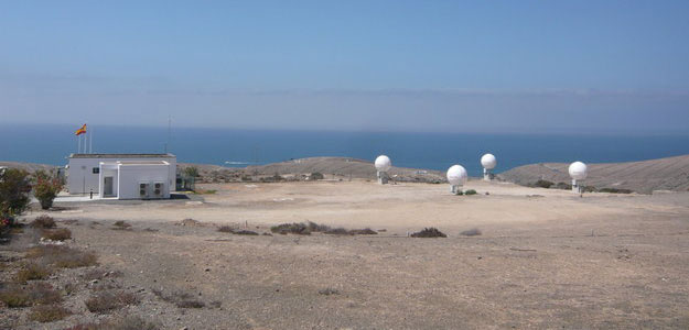
    The European Space Agency’s completion of a pair of dedicated ground stations at opposite ends of Europe has enabled Galileo satellites in orbit to participate in global testing of the Cospas–Sarsat search and rescue system.The Maspalomas station, at the southern end of the largest island of the Canary Islands, at the southern fringe of European waters, was activated in June. And this last month has seen the Svalbard site on Spitsbergen in the Norwegian Arctic come on line — the two sites can already communicate and will soon be performing joint tests.

    This speedy progress has enabled the participation of the latest two Galileo satellites in an international  demonstration and evaluation program — a worldwide test campaign for a new expansion of the world’s oldest and largest satellite-based rescue system, Cospas–Sarsat.

    The Maspalomas station in the Canary Island has an ESA-built Maspalomas Medium-Earth Orbit Local User Terminal (MEOLUT).
    The Maspalomas station in the Canary Island has an ESA-built Maspalomas Medium-Earth Orbit Local User Terminal (MEOLUT).

    Founded by Canada, France, Russia and the U.S., Cospas–Sarsat has assisted in the rescue of tens of thousands of souls in its three decades of service. Distress signals from across the globe are detected by satellites, then swiftly relayed to the nearest search and rescue (SAR) authorities.

    Now the program is introducing a new medium-orbit SAR system to improve coverage and response times, with the Galileo satellites in the vanguard of this major expansion.

    Supporting search and rescue is a separate function to Galileo’s main task of providing global navigation and timing services, but no less important.

    The second pair of Europe’s Galileo satellites — launched together on 12 October last year — are the first of the constellation to host SAR payloads. These can pick up UHF signals from emergency beacons aboard ships, aircraft or carried by individuals, which are then relayed to ground stations. There, the source is pinpointed and automatically passed on to a control center, which then routes it to local authorities for rescue.

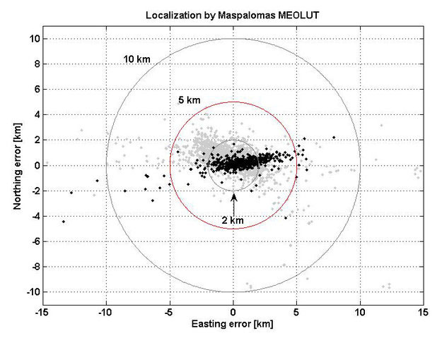
    “The Galileo satellites, tested in combination with the same SAR payloads on Russian Glonass satellites as well as compatible repeaters on a pair of US GPS satellites, showed an ability to pinpoint simulated emergency beacons down to an accuracy of 2-5 km in a matter of minutes,” explained ESA’s Galileo SAR engineer, Igor Stojkovic.

    “Our in-orbit validation tests so far have been in line with expectation and beyond, giving us a lot of confidence in the performance of the final system, once completed.

    “And using a combination of satellites is just how the upgraded system will operate in practice, in order to localise distress signals.”

    Localization test performed from the Maspalomas MEOLUT on 29-30 July 2013 as part of Galileo's search and rescue in-orbit validation. Beacon locations obtained with four satellites are shown in black, while those using three satellites are shown in grey. More than 93% of all beacon locations, after only a single beacon burst has been received, are within the required 5 km from the actual beacon position.
    Localization test performed from the Maspalomas MEOLUT on 29-30 July 2013 as part of Galileo’s search and rescue in-orbit validation. Beacon locations obtained with four satellites are shown in black, while those using three satellites are shown in grey. More than 93% of all beacon locations, after only a single beacon burst has been received, are within the required 5 km from the actual beacon position.
  • Trimble Launches New Geospatial Solutions for Aerial Imaging

    Trimble announced today new additions to its aerial imaging portfolio — the Trimble AX60, a new airborne LIDAR system; and an updated version of its Inpho processing software.

    The announcement was made today at Intergeo 2013, being held this week in Essen, Germany.

    The Trimble AX60.
    The Trimble AX60.

    The Trimble AX60 is a versatile system that can be operated at up to 15,500 feet above ground level (AGL), which meets the requirements for aerial survey projects such as wide area mapping, corridor mapping and remote sensing. Together with integrated flight planning and analysis software tools, the platform has been specifically designed as end-to-end solution that provides enhanced mission flexibility, rapid and efficient point cloud capture, excellent resolution, in-service reliability and high-productivity workflows. The Trimble AX60 can be installed on either fixed wing or rotary aircraft.

    The AX60 has a 400-kHz laser pulse repetition rate (PRR) with a single channel downward-looking laser. An optional, fully calibrated 80-megapixel camera with forward motion compensation can be added. The camera is integrated into the sensor head package and harmonized with the laser system so that it does not need re-calibration each time the solution is fitted to an aircraft. Another key feature is Trimble’s rotating polygon mirror technology for beam deflection that can allow survey missions to be completed faster. This technology provides higher accuracy and a uniform distribution of laser points across the entire field-of-view to widen the usable swath width. Operators can reduce track overlap or duplication, or fly at higher altitudes to achieve a given resolution. Together with a high precision positioning system, integral power supplies, and an in-flight monitoring tool, the Trimble AX60 can allow operators to lower the complexity of airborne LIDAR surveys while increasing the quality of the output.

    “The performance, operational flexibility and reliability of the Trimble AX60 make it an ideal solution for aerial survey companies,” said Phil Sawarynski, business area director of Imaging Solutions for Trimble’s Geospatial Division. “In addition, the Trimble AX60 has been designed as a true end-to-end solution, which includes field-proven Trimble flight planning software and Trimble Inpho analysis software. Since the hardware and software are all supplied by Trimble, operators can have confidence that the complete solution works together seamlessly, and that the flight planning and post-mission analysis suites can enable them to provide a high quality service to their customers.”

    In conjunction with the new airborne laser scanner launch, Trimble also announced its Inpho version 5.6 processing software suite. Version 5.6 now includes the UASMaster module, which has been designed for the complete processing of data acquired by remote piloted aircraft systems (RPAS/UAS). The module georeferences RPAS/UAS images and generates point clouds and othophoto mosaics that allow users to create high quality deliverables for CAD and GIS applications. The UASMaster module is fully compatible with Inpho photogrammetric software modules.

    The Trimble AX60 solution is expected to be available in the first quarter of 2014 through Trimble’s Geospatial Division distribution network. The Inpho version 5.6 and UASMaster is expected to be available in the fourth quarter of 2013.

  • Shipments of Wearable Technology Devices Will Reach 64 Million in 2017

    Google Glass
    Google Glass

    Sales of smart glasses, smart watches and wearable fitness trackers reached 8.3 million units worldwide in 2012, up from 3.1 million devices in the previous year, according to researchers at Berg Insight. Growing at a compound annual growth rate of 50.6 percent, total shipments of wearable technology devices are expected to reach 64.0 million units in 2017.

    According to the announcement, today wearable fitness and activity trackers constitute the vast majority of the shipments. By the end of the forecast period, smart watches are predicted to incorporate much of the functionality of these and will then be the largest wearable device segment. “A perfect storm of innovation within low power wireless connectivity, sensor technology, big data, cloud services, voice user interfaces and mobile computing power is coming together and paves the way for connected wearable technology,” said Johan Svanberg, senior analyst, Berg Insight.

    The first generation of products appeal to specific markets and certain use cases, but refinement in design, technology and connectivity will broaden application areas and speed up market adoption. Initially, the wrist is the most attractive location for wearable devices, which is shown by the success of the Pebble smart watch and the popularity of wristband activity trackers such as the Nike Fuelband and the Fitbit Flex.

    “However, today’s devices need to evolve into something more than single purpose fitness trackers or external smartphone notification centers in order to be truly successful,” continues Svanberg.

    Berg Insight predicts that wearable technology will shift from being smartphone accessories into becoming proper stand-alone computing devices. Furthermore, closeness to the body and always aware capabilities will enable them to be more than merely miniaturized smartphones. Google, Sony and Samsung have already launched products and other major players such as Apple and LG are expected to soon enter the market. Wide market availability of wearable devices also raises privacy concerns. “It is still uncertain where lines should be drawn, but as in the case with most new technology, individual users and solution providers have the responsibility not to misuse the capabilities enabled by wearable tech,” concludes Svanberg.

  • Trimble Offers New Version of Deformation Monitoring Software


    Trimble introduced today the latest version of its deformation monitoring software, Trimble 4D Control version 4.2. The new version of the monitoring software delivers enhanced communications with the Trimble NetR9 and new NetR9 Ti-M GNSS receiver, REF TEK seismic sensors and the Trimble S8 total station. It also supports geotechnical sensors, weather stations, level data and it provides velocity and trend computations as well as a calculation facility for mathematical operations. The interactive Web interface provides advanced alarms, data visualization and analysis tools. Site access is controlled by user login credentials.

    The announcement was made today at Intergeo 2013, being held in Essen, Germany, October 8-10.

    Trimble NetR9 Ti-M. Trimble also introduced a dedicated GNSS monitoring receiver, the Trimble NetR9 Ti-M, designed for real-time monitoring applications. This instrument is the fourth-generation of the proven Trimble NetR9 series of GNSS reference receivers, and is specifically designed for the monitoring market and supported by Trimble 4D Control software.

    Trimble REF TEK Sensors. Following the acquisition of REF TEK, now a division of Trimble and a provider of seismic sensors and data recording instruments, support for REF TEK accelerometers has been included in Trimble 4D Control version 4.2. Different variants of peak acceleration that are used in monitoring the effects of vibration on structures such as micro-seismic activity, proximity blasting or impact piling can be visualized and alarmed in Trimble 4D Control.

    Trimble 4D Control is a fully scalable and comprehensive software solution for both real-time and post-processed monitoring projects. The software solution is ideal for the long-term, automated monitoring of dams, bridges, buildings, support piers, large-scale construction and excavation sites, open pit mines, landslides, tunnels and other structures. Real-time management and control of the monitoring system is available via the Trimble 4D Control Web Interface on-site, online and around the clock from any location with Internet or Intranet connectivity.

    “To date, this advanced technology has only been available to end users of an automated monitoring system.  We recognized the need to provide this functionality across the full spectrum of monitoring applications,” said Ulrich Vollath, general manager of Trimble’s Infrastructure Division. “We are pleased to announce the launch of Trimble 4D Lite, a cloud-based subscription service which will make this solution available to small- and medium-sized monitoring projects. With the introduction of 4D Lite, Trimble’s monitoring solutions are now available for the full spectrum of monitoring projects, from small, non-permanent, campaign monitoring projects through to permanent, fully automated monitoring systems.”

    Trimble 4D Lite – Advanced Cloud Monitoring Service. 4D Lite is a cloud-based application that is designed with an interface familiar to existing Trimble monitoring technology users. 4D Lite is designed for surveyors, engineers and scientists to perform campaign monitoring of data/time series without the need to integrate directly with onsite hardware and sensors. Trimble 4D Lite can be used to meet campaign monitoring needs of installations on dams, bridges, mines, landslides, buildings and other natural and man-made hazards or structures using sensors to monitor health. Data can be integrated from a wide range of sensors. The data can be visualized and analyzed on a variety of interactive charts and scatter plots and the sensors can be viewed in context with the structure using a variety of backdrops including maps, plans or photographs.

    Trimble 4D Control version 4.2, the NetR9 Ti-M GNSS receiver and the 4D Lite monitoring service are available now from Trimble’s worldwide Infrastructure distribution network.

  • Infineon Launches GNSS Module for Mobile Phones

    Today, at the European Microwave Week tradeshow in Nuremberg, Germany, Infineon Technologies introduced the latest generation of its pico GNSS modules for smartphones. BGM1143N9 is a combination of a low-insertion-loss pre-filter and Infineon’s high performance low noise amplifier (LNA) in a TSNP-9 package. The tiny module features very high linearity, a low noise figure, and supports all navigation standards including GPS, GLONASS and BeiDou.

    With a footprint of 1.5 x 1.1 millimeters, BGM1143N9 is one of the smallest GNSS modules available in the market today. It requires 60 percent less board space compared to the previous generation. Size is particularly important for smartphones, since PCB space is a premium.

    Today’s mobile phones offer a wide range of features. Therefore, transmitter and receiver have to work together simultaneously without degrading each other’s performance. A GNSS receiver co-exists with transceivers in the GSM/ EDGE/ UMTS/ LTE bands that transmit high power in the range of +24 dBm. Due to its very high linearity the LNA integrated in BGM1143N9 effectively prevents interference from higher order harmonics and intermodulation products of the strong signal present in smartphones, thus ensuring reliable navigation.

    Furthermore, BGM1143N9 dramatically improves sensitivity compared to other solutions available in the market today. It features the lowest noise figure available in the market (1.45 dB) which increases the GNSS system’s sensitivity and improves time-to-first-fix (TTFF) and time-to-subsequent-fix (TTSF). This feature results in a much faster and continuous navigation and consequently much higher end user satisfaction.

    The new BGM1143N9 supports all navigation standards: GPS, GLONASS, Galileo as well as China’s BeiDou Navigation Satellite System (BDS).

  • Trimble Adds Tilt Compensation to R10 GNSS Surveying System

    The Trimble R10 Surveying System.
    The Trimble R10 Surveying System.

    Trimble announced today several enhancements to the Trimble R10 GNSS Surveying System designed to drive field productivity to a new high. With sophisticated tilt-compensation technology, CenterPoint RTX correction service support, and updated field and office software, the R10 platform demonstrates Trimble’s commitment to driving improved surveying productivity.

    The announcement was made at Intergeo 2013, being held October 8-10 in Essen, Germany.

    “Innovations in techniques such as our tilt compensation technology can have a pervasive impact on the everyday surveying experience,” said Elmar Lenz, business area director of GNSS Solutions for Trimble’s Geospatial Division. “With our innovative approach to total surveying workflow, Trimble is redefining the way surveying work is done.”

    The Trimble R10 is now augmented to further speed GNSS field work. With its new internal tilt-compensation, Trimble SurePoint technology takes field efficiency to the next level. The system will automatically adjust for pole-tilt up to 15 degrees from plumb, saving time and reducing fatigue. With tilt compensation, surveyors can now utilize GNSS in more situations and with 100 percent measurement traceability.

    In addition, Trimble introduced its high-accuracy correction service, CenterPoint RTX, into the geospatial market with support in the Trimble R10. Powered by Trimble RTX technology, CenterPoint RTX is a subscription service that delivers real-time 4 centimeter (1.5 inch) or better corrections via satellite directly to the receiver without requiring the use of a base station, VRS network, or investment in additional hardware.

    Both Trimble Access field software and Trimble Business Center office software have been updated to streamline data flow and automate data processing. Faster in the field and more flexible in the office, Trimble’s premium GNSS surveying system enhances the entire surveying workflow.

    The updates to Trimble R10 GNSS System, CenterPoint RTX service support, Trimble Access version 2013.40 and Trimble Business Center version 3.10 are expected to be available in the fourth quarter of 2013 through Trimble’s Geospatial Division distribution network. For current R10 users, the tilt-compensation feature and CenterPoint RTX support will be available through a free firmware update.

  • Carlson SurveyGNSS for Post Processing Launched at Intergeo

    Carlson SurveyGNSS for Post Processing Launched at Intergeo

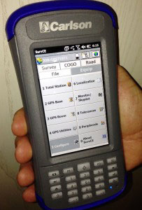
    SurveyGNSS-screen-shot
    Carlson SurveyGNSS post-processing program

    Carlson Software Inc. has developed the new Carlson SurveyGNSS post-processing program, which it introduced today at Intergeo 2013, being held in Essen, Germany. The program is designed for surveyors and positioning professionals looking to achieve centimeter accuracy when working on the edge of their RTK infrastructure, perform sub-centimeter positioning, or provide the highest quality assurance to their customers.

    The data post-processing solution is tightly integrated into the Carlson field and office workflow. SurveyGNSS is designed to accept GNSS data from any receiver in RINEX format. Furthermore, it will also accept proprietary GNSS data in an increasing number of manufacturer formats including NovAtel, Hemisphere GNSS, Altus/Septentrio, and Javad. Additional manufacturer formats will be added in concert with manufacturer cooperation and customer demand.

    “The software has been tested extensively on data sets from around the world with very good results and feedback,” says Bruce Carlson, president of Carlson Software. “Many of our business partners are planning to carry SurveyGNSS and have participated in our pre-release testing.”

    Carlson SurveyGNSS will process GNSS observations in traditional static, “stop and go” (static-kinematic), and kinematic (moving) antenna positioning modes. The software provides a straightforward, workflow-oriented user interface, which includes an overview map and the observation files, computed vectors, and positions presented in fully functional spreadsheet-like grids.

    In addition, Carlson SurveyGNSS provides:

    • A highly autonomous “hands-free” baseline processor offering on-the-fly ambiguity resolution, automated cycle slip detection/removal, and more for baselines up to 200km (125 mi).
    • Automated search and retrieval of reference geodetic control and GNSS observations from public data sources such as the National Geodetic Survey and Continuously Operating Reference Station (CORS) networks in the United States.
    • Rigorous least squares adjustment and analysis of all computed vectors.
    • Seamless integration with downstream applications from Carlson Software and other vendors.

    Carlson SurveyGNSS is being developed in partnership with WaSoft of Dresden, Germany, and its line of GNSS software technologies.

    “SurveyGNSS helps make our survey product line the most extensive in the industry, from field data collection through all forms of processing to as-built mapping and plat drafting,” Carlson adds. “Our flexible licensing arrangements allow single users to process the field data of any number of crews using a wide range of GNSS equipment.”

    Announced at Intergeo in Essen, Germany, Carlson SurveyGNSS is slated to be available from your local Carlson representative or dealer by December 1.

  • Trimble Releases CenterPoint RTX Correction Service into Geospatial Markets

    Trimble announced today that its Trimble CenterPoint RTX correction service will be available to survey and land administration professionals around the world. Powered by Trimble RTX technology, the GPS, GLONASS and QZSS enabled correction service can offer better than 4 centimeter (1.5 inch) repeatable horizontal accuracy, without requiring the use of a base station or local VRS network.

    The announcement was made today at Intergeo 2013, being held this week in Essen, Germany.

    In addition to previously announced Agriculture devices, the CenterPoint RTX correction service is now compatible with the Trimble ProXRT for Land Administration and the Trimble R10 GNSS receivers. The worldwide subscription service is expected to be available to geospatial users in the fourth quarter of 2013.

    Delivered via L-band satellite, CenterPoint RTX is designed for geospatial professionals who are not using RTK as the primary correction source. Advantageous in remote areas that lack local infrastructure and/or cellular coverage, the corrections are delivered directly to the GNSS receiver. No additional hardware, including radios, antennas, or even cellular data plans, is required to use the correction service.

    “By combining global coverage, fast initialization times, and high-accuracy correction data, Trimble CenterPoint RTX offers geospatial professionals unprecedented operating freedom,” said Patricia Boothe, general manager of Trimble’s Positioning Services Division. “We are committed to offering field-proven positioning corrections to address a variety of users’ needs across applications and markets, starting with agriculture and now reaching into the geospatial markets.”

  • Carlson Launches Two Handhelds at Intergeo

    Carlson Launches Two Handhelds at Intergeo

    Carlson Software has introduced a new and improved version of its affordable Qmini data collector. The rugged, but lightweight Qmini2 provides fast processing, yet fits comfortably in one hand.

    Carlson also launched the Carlson MINI2 data collector, which is more rugged, fast, and reliable than its predecessor. It comes with a numerical keyboard for easy coding of points.

    Both products were introduced at Intergeo, being held October 8-10 in Essen, Germany.

    Photo: Carlson Software
    Photo: Carlson Software

    The Qmini2. Weighing 11 ounces (315 grams), the Qmini2 includes a 5 megapixel camera and has a 3.7-inch (480 x 640) sunlight-readable display and comes with a stylus for ease of use. Other specifications include:

    • Works on Windows Mobile 6.5 OS with a PXA310 processor 806Mhz, 256 RAM
    • Provides 8GB non-volatile data storage plus a micro SD card slot
    • Comes with Bluetooth (200-250 meter range to CRx with BT handle), WiFi, Internal GPRS module (data and voice) capabilities
    • Has an internal 32-channel GNSS receiver (GPS + GLONASS) with SBAS (WAAS, EGNOS, MSAS) support
    • Rated IP65 waterproof and dustproof

    The Qmini2 comes with two batteries, a U.S. wall charger, and a soft carrying case. It may be purchased with Carlson’s SurvCE data collection software on board, or with Carlson GIS360, which uses both GIS and surveying technology in the field to collect data. For crash or crime reconstruction, The Qmini2 may also be used with Carlson’s CSI Mobile software.

    For more information or to see the Qmini2 in action, stop by the Carlson Stand #3.097, Hall C, or outdoors at #100 at Intergeo, Oct. 8-10 in Essen, Germany.

    The Carlson MINI2.
    The Carlson MINI2.

    The MINI2. Manufactured to Carlson’s exacting specifications by Juniper Systems, the MINI2 has an extra-large 800 × 480 TFT display for easy viewing of survey data and comes with a fast 1.0-GHz processor. It comes with an integrated 3G modem, 5-megapixel camera, and GPS/GNSS module.

    Its scratch-resistant, touchscreen display is highly readable in both low light and glaring sunshine, providing a sharper image together with notable durability in tough conditions. With a dustproof and waterproof rating of IP68, the Carlson MINI2 also meets the MIL-STD-810G military standard.

    The Qmini2 will be available for purchase from your local dealer on November 1.

    Both products can be viewed at Intergeo Stand #3.097, Hall C, or outdoors at #100. at Intergeo.

  • Topcon’s Hybrid Positioning Combines GNSS, Optical Measurement

    Topcon’s Hybrid Positioning Combines GNSS, Optical Measurement

    Photo: Topcon Positioning Group
    Photo: Topcon Positioning Group

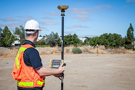
    Topcon Positioning Group announces a new technology — Hybrid Positioning — that increases efficiencies and improves productivity on job sites, regardless of conditions, terrain or location. Hybrid Positioning is enabled through the Topcon Magnet software suite, a Topcon enterprise solution for the geomatics industry.

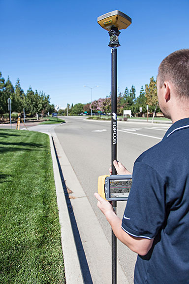
    The new Topcon technology allows precise positioning professionals in the survey, construction, civil engineering and GIS industries to simultaneously connect to GNSS signals and standard robotic measurements on a single rover pole.

    “This extremely clever and unique combination of GNSS and optical measurement is aimed squarely at improving a company’s profitability by allowing the use of GNSS positioning and optical positioning data at the same time,” said Ewout Korpershoek, chief marketing officer of Topcon Positioning Group. “When used with Topcon Magnet software, Hybrid Positioning improves field measurement efficiency at every phase of a project. With Hybrid Positioning technology, the key is versatility. For example, when line-of-sight is blocked, shots can be easily and quickly measured with the GNSS receiver. Now it is so easy to combine a standard Topcon robot and GNSS receiver to guarantee an integrated solution for the highest performance and productivity.

    Photo: Topcon Positioning Group
    Photo: Topcon Positioning Group

    “Combine these two proven solutions, plus advanced Magnet Field software, and you have Hybrid Positioning technology,” Korpershoek said. “By utilizing both GNSS and optical measurement, any project can be completed faster and with unsurpassed accuracy. By adding Magnet cloud-connected data workflow, truly outstanding increases in productivity and cost savings are assured.”

    The new technological breakthrough has four key components: Hybrid Lock, Hybrid Resection, Hybrid Switch and Auto-localization.

    Hybrid Lock allows accurate prism tracking by simply turning the instrument toward the prism location. Hybrid Resection ensures quick job site setup, as well as establishing RTK and geodetic coordinates. Hybrid Switch ensures a quick changeover from GNSS to optical measurement with a single touch. Auto-localization utilizes Bing Maps background, multi-point localization and works with RTK and NMEA positioning.

    “Regardless of job site location or adverse conditions or terrain, Hybrid Positioning systems will perform faster in the field than other instruments and with more versatility than an RTK-only system,” Korpershoek said.

  • Topcon Announces Expanded Features, Connectivity Options with Magnet v2.0

    Topcon Positioning Group announces a multitude of new features and enhanced functionality to the entire Magnet suite of connected workflow software. The Magnet suite includes solutions for the field personnel, the office designers and managing supervisors.

    The release of Magnet v2.0, a Topcon enterprise solution for the geomatics industry, provides more than 30 substantial additions or upgrades to the Enterprise, Field and Office packages. Enterprise is a cloud service designed for the supervising manager that connects the Field and Office products and provides a collaborative web-based interface to company data. Cloud-based collaboration and real-time data exchange makes Magnet a productivity enhancing solution for virtually any operation.

    Magnet v2.0 is now available.
    Magnet v2.0 is now available.

    “Magnet is the industry leader in cloud computing and real-time data exchange,” said Jason Hallett, Topcon vice president for software product management. “Now with v2.0, the total product suite has been elevated to a new level. Not only does Magnet allow for real-time collaboration between the project manager, job foreman, job site crews, office personnel, engineers and consultants, it also introduces myriad new features that will increase productivity in every aspect of every job.”

    Key new developments are expanded functionality for BIM and GIS applications.  Magnet v2.0 now has customized packages designed for building layout and high accuracy GIS application.

    A unique new feature is Hybrid Positioning technology, available in the Magnet Field solution package. It provides the option to simultaneously connect to GNSS signals and robotic measurements on a single rover pole. “This is a powerful feature that is easily managed in Magnet,” Hallett said.

    “Topcon continues to bring efficiencies in productivity by providing the ability to maintain simultaneous connections to a robot and a GPS rover when using the Hybrid Positioning module.”

    Other key features available to enhance data workflow and automation include:

    • AutoCAD 360 cloud surfing: Allows user to visualize, edit and share field projects with non-Magnet users.
    • AutoCAD Civil 3D support: Single-click ability to convert 3D line work generated in Magnet to DWG and launch seamlessly in AutoCAD Civil 3D for review or continued design, and vice versa.
    • Real-time sessions: An office user can log in and connect to any active project, select a field crew and view the field activity and data in real timeMagnet Field-enabled rovers to work from a single cellular-enabled RTK base.
    • Asset manager: Ability to show all active field assets (crews and equipment) in Map View with satellite image background.
    • Third-party file format support: Enlarged library of supported file formats of all major positioning equipment providers, and third-party vendors to Magnet.

    “With Magnet a company can manage its positioning data and field information to ensure maximum efficiency in all facets of each project. The exciting new BIM and GIS features makes it the most productive workflow solution for almost every precise positioning and mapping professional,” Hallett said.

    Magnet v2.0 is available for use with Topcon and Sokkia instruments and is available through subscription service so the user has continuous access to the latest features. Magnet Field and Office products can also be purchased for stand-alone use.