GeoMobile Innovations announced they are conducting an ArcPad 10 workshop on the Oregon State University campus September 12-13, 2013. Taught by ArcPad “guru” Craig Greenwald, the workshop will provide an extensive overview and hands on training opportunity for new and current ArcPad users or GIS administrators who manage and support field crews using ArcPad.
“We will review the new features in the newly-released ArcPad 10.2 such as integration with ArcGIS Online as well as cover the entire soup-to-nuts ArcPad workflow,” said Greenwald, a 7-year veteran of the ArcPad team. “We will also discuss integrating high-accuracy GIS data collection in ArcPad, an increasingly popular trend.”
The workshop will be conducted in Corvallis, Oregon on the beautiful Oregon State University campus. Corvallis is nestled in the heart of Oregon’s Willamette Valley, within 60-90 minutes of the Portland Metropolitan area, mountains, and the spectacular Oregon coast.
Those interested are encouraged to inquire/register quickly. Class size is limited.
GeoMobile Innovations Inc., located in Corvallis, Oregon USA, specializes in ESRI Mobile GIS platforms and has years of experience in field to office data workflow projects, with a forte in high quality Mobile GIS application development. An ESRI Business Partner (reseller, developer, and consultant), GeoMobile’s mission is to work as a partner with clients, empowering them to improve return on investment by implementing quality Mobile GIS and field data collection solutions.
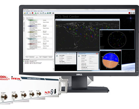
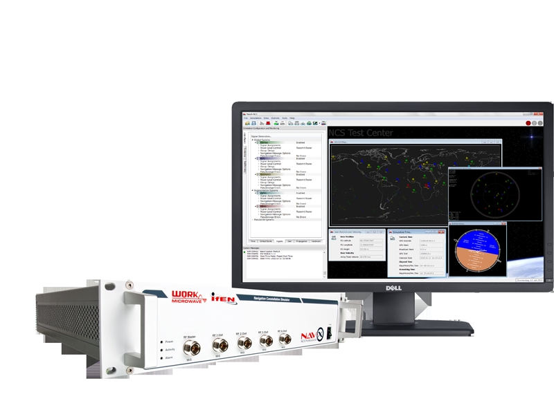
The NavX-NCS GNSS multi-frequency simulator now supports China’s BeiDou-2 navigation satellite system. BeiDou support is a key enhancement in software update V.1.9 for the NavX-NCS GNSS multi-frequency simulator product line, by IFEN andWORK Microwave.
Leveraging new features and functionalities, users have the flexibility to support a wide range of constellations, frequencies, and channels for research and development of GNSS safety and professional applications, as well as system integration and production testing of mass-market applications, such as automotive satellite navigation, mobile-phone applications, chipsets, and handheld personal navigation devices, the companies said.
By enabling real-time simulation of second-generation BeiDou satellite signals, also referred to as BeiDou-2, NavX-NCS expands a user’s GNSS signal capability beyond GPS, Galileo, GLONASS, and SBAS constellations.
“Through a simple software update, NavX-NCS customers can automatically generate signal capabilities for phase two of the BeiDou constellation,” said Dr. Günter Heinrichs, head of customer applications, IFEN GmbH. “Adding BeiDou-2 support to our NavX-NCS simulator comes at the perfect time given the recent release of the BeiDou-2 ICD specification, which outlines interface control requirements for BeiDou-2 B1 satellite signals within the B1 frequency band.”
A powerful new multi-user functionality enables the simulation of up to four different users, or one user with up to four antennas, in different locations simultaneously, IFEN said. Possible use scenarios include simulating a static user such as a reference station at the same time as a roving user, or simulating multiple docking maneuvers on an oil rig. In addition, the NavX-NCS GNSS simulators now include a new 6DOF functionality that makes it possible to simulate six degrees of freedom (three dimensions of space plus yaw, pitch, and roll). This allows even more true-to-life simulations of ships, airplanes, and cars. A new monitoring widget makes it easier to monitor the current state of simulation.
Optimized to perform advanced lever arm calculations, the NavX-NCS GNSS simulators ensure accurate navigation for users. In simulation environments where the antenna is not located in the center of the moving object, such as the external of an airplane wing, lever arm calculations compensate for the fact that acceleration and GPS measurements are not made at the same point. By calculating the lever arm measurement between the PAR antenna and GPS position reference for every epoch of observation, this new feature guarantees that the most accurate signal simulation is achieved.
The NavX-NCS GNSS simulators are available in Professional and Essential versions, both now optionally Export License-Free (LF), speeding up the approval process and delivery time to users abroad. With the Export LF version, users can now limit the simulated user velocity of their simulator equipment to 600 meters per second, eliminating the need for an export license. If an export license should be applied for and be granted later on, it is also upgradeable to a full version meaning the simulation of higher user velocities will be available.
All NavX-NCS GNSS simulators feature up to nine L-band frequencies and 108 channels, offering users more than twice the number of channels compared with standard GNSS simulators. The platform includes a two-year maintenance contract, the broadest range of frequencies and satellite navigation systems per chassis, as well as the flexibility for users to easily install software updates when they become available.
Agency9 CityPlanner, a web service for 3D visualization, has released support for 3D rendering effects such as real time shadow mapping, ambient occlusion, atmospheric scattering and god rays. These effects, traditionally only seen in high-end video games, elevate even the most simple 3D-model and city model to an astounding visually level and enables shadow studies for planners, Agency9 said.
CityPlanner is a tool for intelligent 3D-GIS visualization with the combination of a powerful 3D engine and support for traditional GIS data sources and standards such as KMZ, WMS, GeoTiff, ESRI Shape and more.
Agency9 CityPlanner is a web-based service for 3D visualization of projects within urban development, infrastructure and energy. CityPlanner provides 3D web planning tools for widespread access and collaboration. It is created for urban planners, communicators, consultants and GIS technicians to create, share and publish project and spatial information from a normal web browser. CityPlanner is used by municipalities internationally in their daily work with master and local planning, also involving stakeholders and citizens in the planning process by enabling web publishing of 3D plan visualisations.
“We are very pleased to announce these exciting features that continue to strengthen the position of Agency9 CityPlanner as the premier 3D visualisation tool for the web. CityPlanner is continuously evolving by being developed in close cooperation with the users to ensure that the product supports their workflows and requirements without compromising user experience and usability,” said Johan Göransson, Product manager.
Juniper Systems has released a new version of its field mapping software, Juniper Aspect 1.2. The release builds upon and adds to its previous strengths as an easy-to-use, versatile mapping tool.
Juniper Aspect is a field mapping software designed to boost efficiency and productivity, while being simple enough that anyone can quickly learn how to use it, according to Juniper. It places the capabilities of GPS and GIS in the hands of field workers, resulting in more streamlined processes, the company said. Used for any job that requires locating, documenting, and inspecting assets, Juniper Aspect is a flexible solution for many different lines of work.
Juniper Aspect version 1.2 offers improvements designed to boost worker efficiency and user-friendliness. With a new feature to more extensively filter and organize data, and an ability to more easily import large amounts of data into Excel, Juniper Aspect 1.2 offers greater benefits in time-savings and ease of use, the company said. Furthermore, the software appeals to a broad audience, as it will now operate on most devices running Windows Mobile 6.0 or higher.
“At Juniper Systems, our focus is on the customer,” said Jim Benson, Public Works Market Manager at Juniper Systems. “And that’s why we have implemented many of the new changes in Juniper Aspect 1.2—to respond to the requests of our users. This new release is amazingly easy to use, and yet it does more to make jobs easier and workflows run smoother.”
Current Juniper Aspect customers will automatically receive the new upgrade simply by checking for new updates in their current software version. New customers can contact Juniper Systems to learn more about Juniper Aspect 1.2. They can also download a free preview version of Juniper Aspect.
Apple’s acquisition of WiFiSLAM has brought smartphone indoor location technologies to the fore. With more than 1 billion new smartphones forecast to use indoor location technologies in 2018, there are still significant opportunities for companies with the right technologies and strategies, according to a report by ABI Research.
In ABI Research’s latest Location Technology report, “Smartphone Indoor Location Technologies,” it has forecast the adoption of different indoor location technologies, and the companies that are best placed to be successful. “We see a significant trend towards hybridization, with Wi-Fi, BLE and sensor fusion vital,” said senior analyst, Patrick Connolly. “By 2014, hybrid solutions will have already surpassed standalone indoor location technologies on smartphones, with Wi-Fi and sensor fusion hybrid solutions reaching over 900 million units in 2018. Longer term, technologies around optical light, object recognition and LTE-direct are all forecast to offer differentiation.”
“We are already seeing start-ups pivot out of this space, but there is still huge opportunity for partnerships and acquisitions with major Android handset vendors, carriers and large application developers,” said practice director Dominique Bonte. “Clearly Google is developing its own Wi-Fi indoor location solution; however, it may well open up its indoor location framework, enabling the market to expand much more rapidly. For IC vendors, with access to the hardware abstraction layer, indoor location innovation is vital for future socket wins.”
These findings are part of ABI Research’s Location Technologies Research Service, which includes research analyses, market data, insights, and competitive assessments focused on the indoor location market.
The U.S. Census Bureau released an interactive, online map pinpointing the wide array of languages spoken in homes across the nation, along with a detailed report on rates of English proficiency and the growing number of speakers of other languages.
The 2011 Language Mapper shows where people speaking specific languages other than English live, with dots representing how many people speak each of 15 different languages. For each language, the mapper shows the concentration of those who report that they speak English less than “very well,” a measure of English proficiency. The tool uses data collected through the American Community Survey from 2007 to 2011.
“This map makes it easy for anyone to plan language services in their community,” said Nancy Potok, the Census Bureau’s acting director. “Businesses can tailor communications to meet their customers’ needs. Emergency responders can use it to be sure they communicate with people who need help. Schools and libraries can offer courses to improve English proficiency and offer materials written in other languages.”
According to the announcement, the languages available in the interactive map include Spanish, French, French Creole, Italian, Portuguese, German, Russian, Polish, Persian, Chinese, Japanese, Korean, Vietnamese, Tagalog and Arabic. After selecting one of these languages from the menu, users will see a national population density map, with each dot representing about 100 people who speak the language at home placed where these speakers are concentrated. The map also allows users to zoom in to a smaller geographic area, where each dot represents 10 people. The dots were placed in a random location within census tracts to protect the confidentiality of speakers.
Increase in Non-English Speakers
Also released by the U.S. Census Bureau, the report, Language Use in the United States: 2011, [PDF] details the number of people speaking languages other than English at home and their ability to speak English, by selected social and demographic characteristics. It shows that more than half (58 percent) of U.S. residents 5 and older who speak a language other than English at home also speak English “very well.” The data, taken from the American Community Survey, are provided for the nation, states and metropolitan and micropolitan areas.
The report shows that the percent speaking English “less than very well” grew from 8.1 percent in 2000 to 8.7 percent in 2007, but stayed at 8.7 percent in 2011. The percent speaking a language other than English at home went from 17.9 percent in 2000 to 19.7 percent in 2007, while continuing upward to 20.8 percent in 2011.
“This study provides evidence of the growing role of languages other than English in the national fabric,” said Camille Ryan, a statistician in the Census Bureau’s Education and Social Stratification Branch and the report’s author. “Yet, at the same time that more people are speaking languages other than English at home, the percentage of people speaking English proficiently has remained steady.”
Of the 60.6 million people who spoke a language other than English at home in 2011, almost two-thirds (37.6 million) spoke Spanish.
Reflecting the overall trend, the percentage speaking Spanish at home grew from 12.0 percent in 2005 to 12.9 percent in 2011. In contrast to the overall trend, however, the percent who spoke Spanish at home but spoke English “less than very well” declined from 5.7 percent to 5.6 percent over the period.
The recent increase in non-English speakers continues a trend dating back three decades. Between 1980 and 2010, the number of people speaking a language other than English climbed 158 percent, compared with 38 percent for the overall population 5 and older. The seven-fold increase in Vietnamese speakers was the highest percentage jump among 17 of the most common languages, while Spanish speakers posted the largest numerical gain (25.9 million). In contrast, the number speaking Italian, German, Polish, Yiddish and Greek declined over the period.
Other highlights:
In addition to English and Spanish, there were six languages in 2011 spoken at home by at least 1 million people: Chinese (2.9 million), Tagalog (1.6 million), Vietnamese (1.4 million), French (1.3 million), German (1.1 million) and Korean (1.1 million).
The prevalence of people speaking non-English languages at home varied widely across states, from 44 percent of the population in California to 2 percent in West Virginia.
Laredo, Texas, led all metro areas with 92 percent of residents age 5 and older speaking a language other than English at home.
Metro and micro areas in the West, South and Northeast tended to have higher levels of people speaking non-English languages at home. Those in the Midwest tended to have lower levels, with the exception of Illinois.
Of Spanish speakers, 45 percent of foreign-born naturalized citizens spoke English “very well” compared with 23 percent of foreign-born noncitizens. Those who were native-born, had at least a bachelor’s degree or were not in poverty were more likely to speak English “very well.”
Eighty percent or more of French and German speakers spoke English “very well.” In contrast, less than 50 percent of those who spoke Korean, Chinese or Vietnamese spoke English “very well”. The rate for Spanish speakers was 56 percent.
GNSS Industry Outlook for 2014 Sponsored by:Hemisphere GNSS
Broadcast Date: Thursday, August 15, 2013
Moderator: Alan Cameron, Editor & Publisher, GPS World Speakers: Len Jacobson –GPS consultant,John Pottle – Marketing Director, Positioning and Navigation division, Spirent
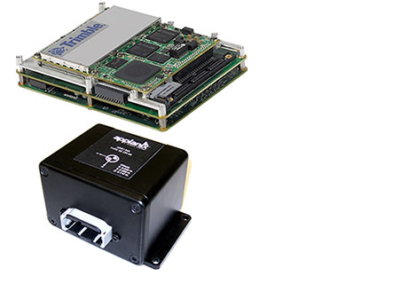
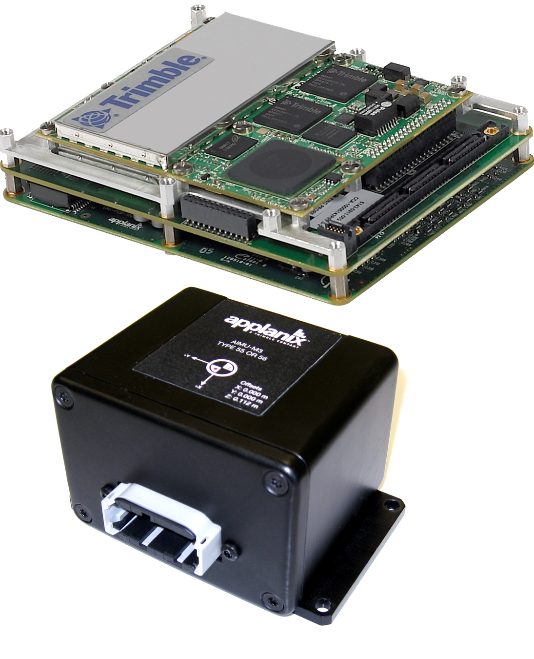
Trimble introduced today the Trimble AP15, the latest member of the AP series of OEM GNSS-Inertial board sets. The introduction was made at the AUVSI 2013 Conference and Exhibition, being held in Washington, D.C.
The AP15 uses a custom Micro Electromechanical Machined (MEMS) based Inertial Measurement Unit (IMU). It is the first product to take advantage of Applanix’ proprietary calibration process — Applanix SmartCal, a new software compensation technology that allows Trimble to achieve exceptional performance from IMUs manufactured specifically for mobile mapping applications.
The AP15 combines high-precision GNSS positioning with Applanix IN-Fusion GNSS-Inertial integration technology, all running on a powerful, dedicated Inertial Engine (IE) board. AP products provide the performance and functionality of Applanix’ POS systems in an embedded form-factor that is specifically designed for third-party manufacturers and systems integrators, Trimble said. The AP Series is designed for a variety of commercial mobile positioning and orientation applications including airborne, terrestrial and marine mapping and guidance for unmanned vehicles.
Combined with a wheel-mounted Distance Measurement Instrument (DMI), the AP15 provides a full 6-degrees-of-freedom navigation solution for land vehicles that is capable of providing robust position and orientation information regardless of obstructions to GNSS-only positioning such as multipath or complete signal loss. Applanix IN-Fusion technology produces uninterrupted position, roll, pitch and true heading measurements of moving platforms by combining IMU data with raw GNSS observables and DMI velocity.
GNSS functionality is provided by a Trimble GNSS module, a dual-antenna, 440 channel, multi-frequency survey-grade GNSS receiver that supports a wide range of satellite signals, including GPS L1/L2/L2C/L5 and GLONASS L1/L2 signals. The module also supports Satellite-Based Augmentation Service (SBAS) corrections, including the U.S. Wide Area Augmentation System (WAAS), European Geostationary Overlay Service (EGNOS), Japan’s Multi-functional Satellite Augmentation System (MSAS) and the OmniStar VBS, HP and XP/G2 corrections.
“Trimble is a leading provider of technology for positioning and orientation solutions and the introduction of the AP15 module continue this tradition,” said Kevin Andrews, product manager. “The AP15 has been designed as a more compact, lighter unit which can deliver excellent performance at lower cost.”
The Trimble AP15 is expected to be available in October of 2013 through Applanix’ sales channel.
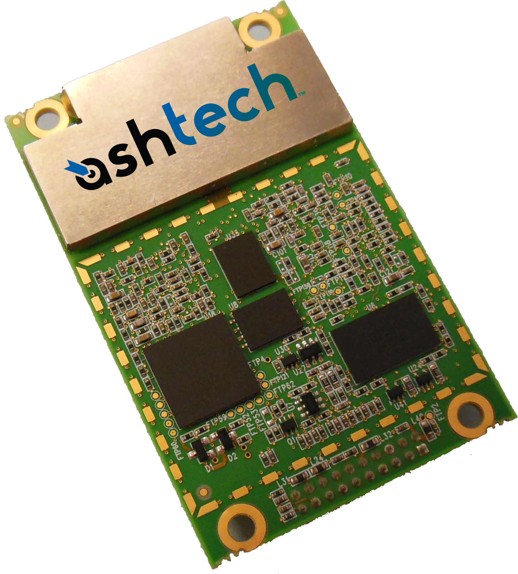
Trimble introduced today the Ashtech MB-One GNSS module. The MB-One delivers highly accurate GNSS-based heading plus pitch or roll in an advanced industry standard form-factor for system integrators.
The announcement was made today at the AUVSI 2013 Conference and Exhibition.
Its embedded Z-Blade GNSS technology uses all available GNSS signals equally, without any constellation preference, to deliver fast and stable solutions. The MB-One is designed to add precise positioning and heading in a wide variety of applications such as unmanned, agriculture, marine and military systems.
“System integrators demand high performance, reliability and support for their positioning solutions,” said Olivier Casabianca, business development manager for the Trimble’s GNSS OEM products. “The MB-One is designed for easy integration and rugged dependability. Users can leverage the module’s Ethernet capability and easy-to-use web browser interface to quickly and cost-effectively develop their products and solutions.”
The MB-One features an enhanced dual-core GNSS engine with 240 channels capable of tracking a large range of GNSS systems including GPS, GLONASS, Galileo and BeiDou. It uses over-the-air satellite corrections using L-Band hardware to achieve decimeter-level accuracy. The module is capable of receiving and decoding Precise Point Positioning (PPP) to output a highly accurate position solution that removes the need for a local base station.
The Ashtech MB-One module will be available through the Trimble GNSS OEM international network of representatives and authorized dealers. Evaluation units will be available in the fourth quarter of 2013 and production units are expected to be available in the first quarter of 2014.
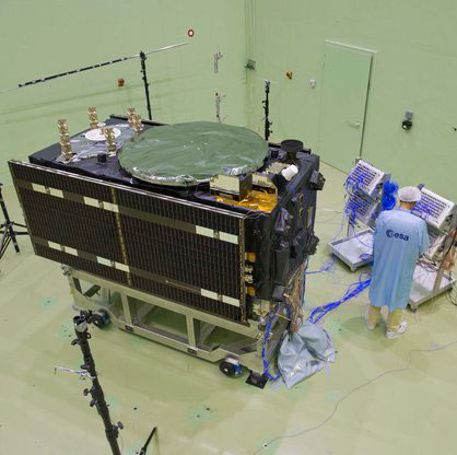
There might seem to be a hole in the side of this Galileo satellite — in fact its folded solar wings are simply reflecting a noise horn in the wall, about to recreate the deafening roar of a rocket lifting off.
Anyone witnessing a rocket launch will be struck by the noise levels, even when observing from several kilometres away. A satellite on top of its launcher is exposed to much higher levels, of course. So testing is essential to ensure that the satellite structure can withstand such a sustained loud sound.
This first Galileo Full Operational Capability (FOC) satellite, successor to the four Galileo navigation satellites already in orbit, underwent acoustic testing in July, part of a full-scale test campaign taking place at ESA’s ESTEC Test Centre in Noordwijk, the Netherlands.
The satellite was placed in the Large European Acoustic Facility, LEAF, effectively the largest sound system in Europe. A quartet of noise horns are embedded in one wall of this 11 m wide by 9 m deep and 16.4 m high test chamber.
Noise is generated by passing a carefully modulated flow of gaseous nitrogen through the horns, following the predetermined test profile — this inert gas selected to avoid any contamination of any delicate onboard systems, the satellite having been placed in flight configuration for the purpose of the test.
“The acoustic noise level reached during the test was 140.7 decibels, about the same noise as standing 25 m away from a jet taking off,” explained Georg Deutsch of European Test Services, the company operating the Test Centre for ESA.
“This involved a maximum liquid nitrogen flow in this case of 3.5–4 kg per second. Liquid nitrogen delivered by tanker is vaporised to pass through the horns. More or less, we were able to finish this test campaign with one full tank of liquid nitrogen — about 18.5 tons.”
Galileo in flight configuration for acoustic testing.
Once the massive door of the LEAF is closed, its 0.5 m-thick steel-reinforced concrete walls serve to safely contain the sound. These are coated in turn with thick epoxy resin whose reflectivity increases internal reverberation.
The chamber itself is supported on rubber bearing pads to isolate it from its surroundings.
The Galileo satellite itself was similarly isolated — its support structure being borne on air-based “vibration isolators” to make sure any vibration that ensues is due to direct acoustic noise as opposed to resonance from the ground.
The satellite had to be fitted with dozens of accelerometers to detect internal vibration — large items such as batteries are most prone. The blue cables shown relay accelerometer data. It was also surrounded with microphones to check the acoustic noise around the satellite followed the planned profile, providing around 250 data channels in all.
This second FOC satellite arrived at ESTEC on 9 August from manufacturer OHB in Bremen, Germany.
A total of 14 FOC satellites are being produced as part of the first work order for Galileo FOC, which will involve a continuous round of testing at ESTEC as an integral part of their path to orbit. A second work order of eight satellites has been also released to OHB and their production will follow the production of the first batch.
LEAF.
This first Galileo FOC satellite has since had its delicate solar wings removed as part of its preparation for ‘thermal vacuum’ testing. It will stay in a vacuum chamber for weeks on end and be subjected to the same temperature extremes it will experience in orbit.
Once unboxed, the second FOC satellite will undergo a similar acoustic testing and then a System Compatibility Test Campaign
will be performed, linking it up with the Galileo Control Centres in Germany and Italy and ground user receivers as if it was already in orbit.
Painting of Colonel Francis Xavier Kane (courtesy of the USAF Space and Missile Pioneers).
Plus: The First Installment of ‘What Is Don Reading?’
This month I planned to catch up on all those important topics that need to be written about but don’t make the cut, mainly due to space limitations — and then came the sad news of the passing of a good friend, mentor, and great Space and Missile Pioneer, Colonel Francis Xavier Kane, Ph.D., USAF Retired, born on December 12, 1918, in Philadelphia, Pennsylvania. To put this date in perspective, consider that the first successful Wright Brothers flight at Kitty Hawk occurred in 1903.
Known simply as “Duke” to his friends and colleagues, he went to be with the Lord on July 18, 2013. He was 94 years old, and the majority of those years were filled with futuristic thoughts and writings about what we could achieve in the heavens above us, and accomplishments that support the Space Age we all live in today.
I first met Colonel Kane in 1973, a full three years after he retired with 27 years of active duty in the USAF. Duke graduated from the U.S. Military Academy at West Point in 1943 in the middle of WWII. In those days, there was not an U.S. Air Force Academy. What would become the U.S. Air Force was then known as the Army Air Corp. The USAF did not become a separate military service until September 18, 1947, with the implementation of the eponymous National Security Act. Still, Duke found himself in an Air Force uniform, flying airplanes and instructing others how to fly. He loved flying, but as you will soon discover, he was an engineer and professor at heart. He played to his strengths.
I never knew Duke while he was in uniform. Despite my best efforts to refer to him with proper military courtesy as Colonel Kane, he quickly remonstrated me and informed me that to his friends and colleagues he was known simply as Duke, and so “simply Duke” it has been for the last 40 years. At the end of our conversation about appropriate appellations, he added, “And no one calls me Francis-Xavier except my wife Virginia, and then I know I’m in the dog house!” (Ed: Duke and Virginia were married for 67 years).
Duke Kane was the first to send me a wonderful handwritten letter of congratulations via snail mail back in 2007, when I penned my first column as the Defense Editor for GPS World magazine. The letter was extremely complimentary, with high praise I had certainly not yet earned, but then that was Duke — always supportive. Comments in his letter I will always treasure are “Finally, we have someone writing regularly about GPS that actually knows what he is writing about…and don’t forget, Don, I have declassified history files dating back to the early days of the 621B program and they are always at your disposal.”
I heard regularly from Duke, several times a year at least, and it was always a note of encouragement or praise; what every journalist needs. It meant a lot to me personally that it came from Duke because, you see, Duke was a very prolific writer and thinker himself, and perhaps at times even a frustrated journalist. Some of his wonderful and insightful writing on the possible uses of the “Space Domain” as a medium for our future infrastructure are seminal and even legendary today — such as the one he wrote on terrestrial navigation using space assets, which helped spawn the aforementioned 621B program that led to the Global Positioning System. More on that later.
Duke was a prolific writer, but rarely took credit for his futuristic ideas. While serving as an Air Force planner, Duke penned papers concerning the initial development and importance of systems analysis and applications of early computers for both terrestrial and space applications. Early on, Duke saw the need to develop a coherent planning and policy environment in the DoD (Department of Defense) to enhance the evolution of and to formally inculcate the U.S. space program, to include systems and technology planning.
In the early 1960s, Duke wrote profusely concerning space-based missile warning, known today as the DSP or Defense Support Program and more recently as the SBIRS or Space-Based Infrared System. He wrote about manned space maneuvering vehicles, now known as the Space Shuttle, which came and went during his lifetime, as well as the detection and tracking of mobile missiles and the possibility of shooting them down with lasers. He also wrote about lasers as “blindingly effective” anti-satellite weapons, a capability and problem that modern planners and operators are still worrying about and dealing with today. He wrote about advanced ballistic missiles, which we know today as the MX or the Peacekeeper program.
He was always ahead of his time. He wrote knowledgeably about space-based missile defense, a theme he would later revive as a member of the GPS Independent Review Team (GPS-IRT), which several of us invited him to join because in the 1960s he penned significant white papers concerning the possibility and credibility of navigation satellites, which of course we know today as the Global Positioning System. He was, in many respects, a visionary.
Before his retirement in 1970, Duke managed to find the time to complete a master’s degree in political science and a doctorate from Georgetown University. He went on to teach courses at UCLA, the University of California at Los Angeles, the Catholic University of America, and Pepperdine College.
Duke loved to think and write about the future. One of his favorite topics was the Global Positioning System, which in many respects sprang from the classified 621B program he supported toward the end of his Air Force career.
Aerospace Corporation Historian Steven R. Strom, in his insightful writings and interviews with luminaries of the early U.S. space programs, with an emphasis on the history of GPS, wrote that in 1963 the Air Force Space Systems Division funded Colonel Kane to lead a classified project known as 621B. Phase one of 621B featured the engineering concept for a “space-based navigation system,” later to become known as the Global Positioning System or more formally as the GPS/NAVSTAR. According to Colonel Bradford Parkinson, Ph.D. USAF, retired — and the first GPS Program Manager/Director at what is now SMC — Project 621B had “many of the attributes that you now see in GPS. It has probably never been given its due credit.”
Duke never forgot those early days or got over his involvement and fascination with GPS. In 1993, 23 years after his retirement from active duty, Duke founded the GPS International Association. He served on the U.S. Department of Transportation Civil GPS Service Interface Committee and authored more than 20 significant articles on GPS and other critical space-based systems.
Finally, in 2010 Duke was inducted as an Air Force Space and Missile Pioneer — his picture and a short biography hang in the entryway of AFSPC (Air Force Space Command) Headquarters (the Hartinger building) on Peterson Air Force Base in Colorado Springs, Colorado — a well-deserved honor of which Duke was extremely but humbly proud.
Colonel Francis Xavier “Duke” Kane — fighter pilot, flight instructor, engineer, professor, visionary and, for many, a friend and mentor who will be sorely missed.
Now on to the Catch-up Topics…
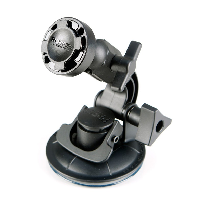
As my regular readers are aware, I generally take a long time to evaluate PNT and PNT-related equipment sent for me to review, and I only review about one in twenty items. For years I have reviewed and recommended OtterBox equipment for keeping iPads, iPhones and assorted PNT handhelds safe from the environment. They are indeed some of the best add-on “ruggedizers” I have ever encountered. However, a few weeks ago I called the wonderful folks at OtterBox to enquire about a rugged mounting system for PNT equipment and discovered to my dismay that they just don’t do that. Not an area of expertise for them. Fair enough, and I certainly appreciated their honesty. Then, out of the blue, I received an email from Francesca Marino at Blast Media on behalf of Rokform, a relatively new U.S. company that builds rugged mounting systems that she said were perfect for our warfighters. She even included the following advertisement/vignette:
Made in the USA, all Rokform products are designed and engineered of CNC aircraft grade aluminum. Each accessory allows soldiers to mount their phone magnetically, or by Remote Mounting System (RMS), to dashboards of any vehicle. A member of the Navy inland search and rescue team accounts his experience with Rokform’s RokBed v3 case while on duty for helicopter rappel operations:
“I’m active duty military, and one of our engineers bought the magnet for his [Rokform] case as I had. While standing on the quarterdeck, he accidentally dropped his phone and tried to kick it back onboard before it went in the drink. He only succeeded in kicking it overboard…only to have it catch itself on the side of the ship! Several others saw what happened and were surprised when he was able to retrieve his phone from its watery grave! I had to share that story as you had to be there to believe it.”
Francesca asked if I would be interested in receiving a sample of a Rokform rugged smartphone or iPad case for testing.
I took Francesca up on her offer, and frankly, I am impressed with the earth-magnet mounting system on the Rokform equipment cases, and especially with the v3 mounting system (see picture). I have used the v3 for a couple of months in numerous rental cars and with both my iPhone and my iPad — it works flawlessly. It has never released involuntarily even on hot and cold surfaces, and it has never dropped my iPhone or iPad on the dash. Not something I can honestly say about any other device of this type I have tested. I also use the v3 at home on a granite counter top Sometimes just getting it unstuck is a chore, but a happy one. It simply works as advertised; it holds whatever you attach securely and effectively, and has the flexibility and maneuverability to do so in all kinds of environments. It is truly rugged, versatile and very useful. It stays where you mount it, and it is made in the USA. I highly recommend it.
The Rokform v3 mounting system.
Specifications:
There are numerous hands-free options for the v3 Suction Mount. Attach the mount to any smooth, flat, non-porous surface, and adjust to your ideal viewing angle. A few of the locations I tested include a conference table, desk, car window, windscreen, mirror, and sunroof.
Features
Polycarbonate and die cast zinc construction
360-degree turn and rotation
210-degree tilt for ideal viewing angles
Powerful suction pad measures 3.4 inches (86.4 mm) in diameter
The v3 is compatible with all v3 mountable phone cases, which pretty much covers the waterfront on phone cases, and so they should have one that fits your needs.
There is a separate attachment for your mobile devices that uses adhesive if you just don’t want to use the suction cup model — just beware that once you attach the separate small earth-magnet device, to a case or your automobile, it is not coming off. Be sure you want it there permanently. I view this as a good thing: no falling iPhone or iPads. But it is just something you need to contemplate. Of course, the v3 works with a tenacious suction cup, so there is not a permanence issue with that device. Try it.
What Is Don Reading?
Ever since I started penning this column and mentioning books I have read or am reading and frequently quoting from them, I have received a steady array of requests to discuss the books and recommend or review them, even if they are not primarily about GPS or PNT.
Certainly, locating books to review is not an issue. My wife calls me a parallel reader, in that I am generally reading two, three, even four books at a time. The question is will any of them be of interest to you? Let’s find out. While we are not sure this feature will appeal to all of you, or if we can make this a regular feature due to time and space limitations, we will give it a trial run this month. Please let us know what you think and what you are reading that may be of interest to our readers, at [email protected].
I recently had the pleasure of reading two books about wartime that cover two distinct periods of time and are actually in different genres. However both books are fascinating for very different reasons.
Viper Pilot: A Memoir of Air Combat, by Dan Hampton (USAF, Ret).
This book is a “must-read” for air combat aficionados in that it is a seat-of-the-pants warfighter, fighter-pilot view of the air wars in Iraq, Afghanistan, and Kosovo. It is also a very candid fighter pilot’s view of how those wars were managed or not managed, as the case may be. Dan certainly pulls no punches, and if you have any romantic visions of aerial combat and how it comes about — as portrayed in movies like Twelve O’Clock High — then this book may prove to be an eye-opener.
Be warned, it takes a chapter or two for Dan to set the hook, but if you are still engaged by chapter three, you should be good and firmly on the line. The first two chapters are more of what those of us in-the-business refer to as standard fighter-pilot rhetoric, as in “I am god’s gift to the world and am without a doubt the world’s best fighter pilot.” Indeed, the first two chapters do a good job of substantiating the old barb, “You can always tell a fighter pilot, but you can’t tell him much.” Today, to be politically correct, I guess that would have to be him or her much.
However, in retrospect, who would want to read a book by a warfighter, especially an F16C Wild Weasel fighter pilot, who was not absolutely sure of his or her superiority? Not me. Indeed, another old barb that applies here, “There are bold pilots and old pilots but very few old bold pilots.” After you read Viper Pilot, I think you will agree than Dan Hampton, who by his own humble admission is one of the most decorated F-16 pilots in American history, is certainly the exception to the rule.
Most importantly, Dan Hampton gets it right, technically and operationally. His frustration with incompetent ground-pounders and support personnel notwithstanding, he tells it like it is, and you quickly detect that his frustrations are probably justified and his feelings, which he freely shares without compunction, are certainly justified, at least in his view of the world.
As far as I can decipher, and I was in that business for almost thirty years, there are no glaring errors or even small mistakes about procedure, process, or organizational charts. He tells it like it is and lets the pieces, whether blame or commendation, fall where they may. It is a great read, and one that all history, war, airplane and aerial-combat buffs will find a must read. And yes, there are numerous references to GPS and GPS-guided weapons and effects. I thoroughly enjoyed it — even though the language can at times be a bit over the top and is totally unnecessary to the storyline, but then, when you are God’s gift to fighter pilots, what do you expect?
By the way, rumor has it Dan is in the process of writing another book. I, for one, can’t wait.
The Ledger, by Lloyd Holm
This wartime romantic novel by Lloyd Holm is certainly a departure from Viper Pilot. This book is romantic in nature, but in a good way, and yet is also a very true and authentic synopsis of what it was like during both WWI and WWII, which was globally known as the “War to end all Wars.”
Lloyd Holm does a great job of setting the hook immediately. No waiting. I read it in one sitting and was disappointed only because it was over. I wanted the story to go on and on. Hint to Mr. Holm: There is certainly a sequel here if you have it in you.
This fast paced riveting story concerns two families and their involvement with each other during both world wars. The story more or less begins with a very authentic and well-documented event, the 1914 lull in fighting due to the spontaneous and unofficial 24th of December Christmas Truce during WWI. Both Allied and German soldiers meet in “No Man’s Land” between the trenches to exchange food, stories and camaraderie. During this incredible event, the lives of two families, German and Jew, become irrevocably intertwined — the rest, as we say, is history and the storyline of The Ledger.
This wonderful book is authentic and detail oriented. I could find no fault with the well-documented history, the unit designations, or the language, as English, French, and German words are used liberally and in the correct context.
Whether you read this book as an historian, a romantic, or a war buff, you will find it satisfying on all accounts, and I dare you to put it down once you start. Sequel?
Until next time, read a good book and happy navigating.