Blog

  • Norwegian Company Gives Galileo Its Voice

    Norwegian Company Gives Galileo Its Voice

    Galileo hardware ready for delivery. The last three Search and Rescue Transponders (SARTs), left, and the last two Frequency Generator and Upconverter Units (FGUUs), right, units produced by Kongsberg Norspace under the first work order for the first 14 Galileo Full Operational Configuration (FOC) satellites being prepared for shipment to Surrey Satellite Technology Ltd, seen together with some of the key project team members.
    Galileo hardware ready for delivery. The last three Search and Rescue Transponders (SARTs), left, and the last two Frequency Generator and Upconverter Units (FGUUs), right, units produced by Kongsberg Norspace under the first work order for the first 14 Galileo Full Operational Configuration (FOC) satellites being prepared for shipment to Surrey Satellite Technology Ltd, seen together with some of the key project team members.

    A trans-European production line is progressively transforming the Galileo satnav system into a working reality, according to the European Space Agency (ESA). The 22 satellites so far contracted to join the four already in orbit are having their payloads manufactured at Surrey Satellite Technology Ltd. in the UK, which are then integrated to their satellite platforms at OHB in Germany. Finally, each complete satellite is tested at ESTEC in the Netherlands for launch from Europe’s Spaceport in French Guiana.This main manufacturing process is fed by smaller but no less crucial production lines all across the continent, run by specialized companies supplying essential building blocks to Galileo’s prime contractors, ESA said.

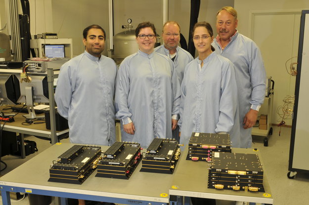
    The old Norwegian naval town of Horten, just south of Oslo, is home to Kongsberg Norspace, a 95-strong company contributing two key elements to these next 22 Galileo Full Operational Capability satellites.

    “We won the contracts to supply the Frequency Generator and Upconverter Units (FGUUs) and Search and Rescue Transponders (SARTs) for all the Galileo FOC satellites,” explains Sverre Bisgaard, CEO of Kongsberg Norspace.

    The shoebox-sized Frequency Generator and Upconverter Units (FGUU) is a pivotal item of equipment that takes the outputs of the satellite’s adjacent Navigation Signal Generator Unit and converts them into L-band signals across Galileo’s three spectral bands. It is these signals that end up guiding Galileo users through their receivers.
    The shoebox-sized Frequency Generator and Upconverter Units (FGUU) is a pivotal item of equipment that takes the outputs of the satellite’s adjacent Navigation Signal Generator Unit and converts them into L-band signals across Galileo’s three spectral bands. It is these signals that end up guiding Galileo users through their receivers.

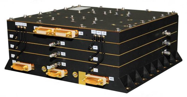
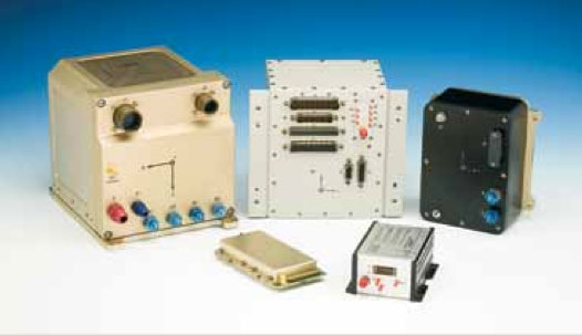
    The shoebox-sized FGUU is a pivotal item of equipment, effectively giving Galileo its voice. “It takes the outputs of the satellite’s adjacent Navigation Signal Generator Unit and converts them into L-band signals across Galileo’s three spectral bands. It is these signals that end up guiding Galileo users through their receivers,” Bisgaard said.

    “These signals end up being very low power by the time they reach the ground, so maintaining the signal quality is key, in terms of power range, frequency shape and low noise. The FGUU actually relies on Galileo’s atomic clocks to keep accurately locked on its set frequency. It also actively determines which of the clocks and other redundant subsystems it should employ at any one time for optimal operations,” Bisgaard said.

    Kongsberg Norspace’s second, similarly sized contribution is the SART, which picks up emergency distress calls from the ground or sea and relays them to the nearest rescue centre, while also sending a return-link message that help is on the way. Galileo’s search and rescue capability marks a significant enlargement of the international Cospas–Sarsat system, which has been active for more than three decades and rescued thousands of lives.

    The company won the SART contract having previously supplied similar transponders to ESA’s Meteosat Second Generation satellites.

    “The SART’s job as a transponder is just to relay messages, theoretically a simple task but requiring clever design to make it work,” adds Mr Bisgaard. “The SART is operating across noisy frequencies, and has to recognise, filter and amplify the very weak messages in question without missing anything.

    “So both FGUU and SART have a need for effective filtering in common, to ensure that they are processing the right frequencies with the right signal shape without any garbling. This filtering is performed physically, based on ‘Surface Acoustic Wave’ (SAW) technology.

    “SAW makes use of the physical effect called ‘piezoelectricity’ – if an electrical field is applied to quartz it is converted to a mechanical or acoustic wave. By converting our electrical signal in this way then converting it back again the signal can be filtered and shaped as desired. This is one of our key technologies and in fact ESA recognises us as a preferred supplier for SAW systems.”

    While the FGUU has embedded redundancy and the SART is a non-redundant unit, one of each design is being supplied for each Galileo satellite, a total of 44. Batch production is a shift from how the space industry traditionally operated, with bespoke designs for each individual satellite, but Kongsberg Norspace has had a lot of experience working in such a way.

    “We’ve had similar series contracts in the past, for instance contributing 48 identical units to five satellites of the Russian Express-AM series and up to 12 units per satellite for the 64-satellite Globalstar low-Earth orbit telecom constellation.

    “We’ve already delivered units to SSTL for the first 14 satellites, which was the first contract won, with the next eight in production. It is SSTL who set the technical requirements and give us information on the interfaces with the other items of equipment, such as the clocks and navigation signal generator unit. We deliver directly to SSTL where the integration is performed.”

    Norspace has been doing business for just under three decades, originally formed as a subsidiary of another company before being spun out. In 1986 it won its first ESA contract, supplying systems for the Agency’s ERS-1 remote sensing missions, subsequently diversifying into the US telecommunications market under the ownership of Alcatel.

    A decade ago a management takeover took place, with the company bought by Kongsberg in 2011. Upwards of 150 satellites rely on hardware supplied by the company.

    “Telecom missions remain an important part of our business, but Galileo is becoming more important – it represented 40% of our sales during the last couple of years.

    “We have been involved with Galileo since the start, supplying equipment for the initial testbed systems, then the GIOVE-A and -B test satellites and the initial In-Orbit Validation quartet of satellites. We hope to maintain our involvement into the future as Galileo evolves, so we are discussing about joining with primes to prepare for future bids.

  • CHC Offers LT400HS GNSS Handheld

    CHC Offers LT400HS GNSS Handheld

    CHC
    The LT400HS GNSS by CHC.

    CHC today announced the availability of the LT400HS, a rugged 120-channel GPS+GLONASS handheld receiver designed to achieve sub-meter SBAS positioning to centimeter accuracy in RTK networks. The LT400HS is designed to be a cost-effective yet powerful GNSS device for survey, construction and GIS professionals.

    The LT400HS is designed for companies that have not yet invested in GNSS technology due to cost or occasional equipment use, such as earth-moving and landscape contractors, real estate developers, construction SMEs, agriculture irrigation companies, and utilities mapping companies.

    “The LT400HS GNSS handheld series is a compact, rugged, accurate and easy-to-use GNSS receiver to perform surveying and precision mapping tasks wherever RTK Network corrections are available,” said George Zhao, CEO of CHC. “The LT400HS offers unrivaled performance, an attractive price point filling the price performance gap that exists in the industry between GIS level collectors and professional RTK rovers such as our recently introduced X+ GNSS Series. ”

    The LT400HS Series features:

    • Professional 120-channel GNSS Engine – L1/L2 GPS + GLONASS supporting RTCM network RTK corrections and industry standard NMEA output.
    • 3.7” daylight readable transflective VGA touch screen.
    • Built-in GSM/GPRS phone with data transmission, Bluetooth and Wi-Fi connectivity.
    • Built-in 5 megapixel autofocus camera to capture assets information.

    It comes bundled with Carlson’s SurvCE software for survey and construction professionals, or DigiTerra Explorer Mobile GIS software  for accurate GIS field data collection and maintenance.

  • U.S. Census Bureau Releases 2013 TIGER/Line Shapefiles and TIGER Geodatabases

    The Geography Division of the U.S. Census Bureau has released two sets of Topologically Integrated Geographic Encoding and Referencing products: the 2013 TIGER/Line shapefiles and the TIGER geodatabases. Both are extracts of the Master Address File/TIGER database and can be used with Geographic Information System software to map census geographic areas and features such as roads and rivers.

    The TIGER/Line shapefiles are updated yearly, and this version includes a new coastline feature. The TIGER geodatabases include national- and state-based files often requested by customers and provide the ability to download multiple layers in a single file. Both the 2013 TIGER/Line shapefiles and the TIGER geodatabases can be downloaded from the website.

    • Shapefiles are released in one of three types of coverages:
      • Nation-based
      • State-based
      • County-based
    • The table below lists each type of geography and the coverage(s) at which each is available.
    2013 TIGER/Line Shapefiles Availability
    Layer
    Nation-Based Files
    State-Based Files
    County-Based Files
    Note that not all files exist for all states or all counties.
    Shapefiles – Boundaries
    Alaska Native Regional Corporation

    X

    American Indian Tribal Subdivision

    X

    American Indian/Alaska Native/Native Hawaiian Areas

    X

    Block

    X

    Block Group

    X

    Census Tract

    X

    Combined New England City and Town Area

    X

    Combined Statistical Area

    X

    113th Congressional Districts

    X

    Consolidated City

    X

    County and Equivalent

    X

    County Subdivision

    X

    Elementary School District

    X

    Estates

    X

    Metropolitan Division

    X

    Metropolitan/Micropolitan Statistical Area

    X

    New England City and Town Area

    X

    New England City and Town Division

    X

    Place

    X

    Public Use Microdata Area

    X

    Secondary School District

    X

    State and Equivalent

    X

    State Legislative District-Lower Chamber

    X

    State Legislative District-Upper Chamber

    X

    Subbarrio (Subminor Civil Division)

    X

    Tribal Block Group

    X

    Tribal Census Tract

    X

    Unified School District

    X

    Urban Areas

    X

    5-digit ZIP Code Tabulation Area

    X

    Shapefiles – Features
    Address Range-Feature

    X

    All Lines

    X

    All Roads

    X

    Area Hydrography

    X

    Area Landmark

    X

    Coastline

    X

    Linear Hydrography

    X

    Military Installation

    X

    Point Landmark

    X

    Primary and Secondary Roads

    X

    Primary Roads

    X

    Rails

    X

    Topological Faces (Polygons With All Geocodes)

    X

    Relationship Files
    Address Range-Feature Name

    X

    Address Ranges

    X

    Feature Names

    X

    Other Identifiers

    X

    Topological Faces-Area Landmark

    X

    Topological Faces-Area Hydrography

    X

    Topological Faces-Military Installations

    X

  • Report Looks at Market Factors for Indoor Positioning

    In recent years, there has been a substantial demand for indoor positioning and navigation equipment in the marketplace across verticals. Research and Markets has released a new report that indicates that there are multiple factors shaping the future of the indoor location market.

    One such factor is the increasing number of applications that are addressing the expressed market need. Another is that the need to deploy cost control measures is being fulfilled by the indoor location apps. Even though the adoption of this technology is relatively slow, due to indoor environment challenges and performance requirements, these solutions are expected to grow steadily and shall have a pervasive existence across all the major verticals. Improved customer experience, on a real-time basis, will be the major pull factor, according to the report.

    The indoor location research report analyzes global adoption trends, drivers and evolving platforms in this rapidly emerging market. The report aims at identifying and evaluating the current market size and the future market opportunities.  Some of the major vendors of indoor location are Apple Inc., Google, Microsoft, Broadcom and Cisco. Many small innovative companies have also surfaced and are forthcoming as the solution providers for the indoor location market.

    The research report, “Indoor Location Market: Global Advancements, Market Forecasts and Analysis (2013 – 2018),”  categorizes the global market for indoor location into the following sub-markets:

    Hardware devices: This segment shows the hardware technological trend and its inevitable effect on indoor location market.

    • Handheld devices: This segment gives unit shipments for smartphones, 3D enabled smartphone, tablets and 3D enabled tablets in this segment.
    • Network devices: This segment covers Wi-Fi integrated chips and Bluetooth integrated chips with their expected unit shipments over the period.
    • Proximity devices: In this segment, we cover expected global unit shipments for sensors.

    Software: This segment refers to indoor maps and navigation software packages which can be downloaded into the hand-held devices for indoor location purposes. It also covers indoor location-based analytical tools to monitor patterns of pedestrian/ customers at various venues. Revenue generated from proximity engine is also included in this segment.

    For more information, visit the Research and Markets website.

  • Smartphone Market to Fragment in Emerging Markets

    New findings from leading hi-tech analysts, Juniper Research, has revealed that the Smartphone OS market will see new emerging players, such as Asha, Sailfish and emerging HTML 5 based OS players begin to gain ground in niche areas. The market globally however is expected to continue to be dominated by Android and iOS.

    The report argues that these new contenders will take away important niches – focusing on cost innovation and utilising local knowledge – in synergy with the next generation of consumers. This may begin the slow decline of the current global OS elite.

    Global Smartphone Dichotomy

    In terms of smartphone shipments, Apple and Samsung will continue to dominate the global market, shipping 17% more smartphones in 2018 than were shipped globally by all vendors in 2012. The new Juniper report found that Apple and Samsung’s global smartphone shipments will hit nearly 800 million by the end of 2018, compared with 677 million last year.

    Apple’s New Horizons

    Juniper’s latest report, ‘Smartphone Futures: Differentiation Strategies & Emerging Opportunities 2013-2018’ forecasts sustained growth for Apple in the emerging markets over the forecast period, with Apple expected to announce a diversification in its product portfolio shortly. It notes that this brings Apple closer to the Samsung model of catering to diverse set of markets utilising different models which will maintain the current global dichotomy.

    New Region New Rules

    The new report noted that significant growth is expected across emerging markets such as the Indian Subcontinent and China. These areas will see particular growth in the Ultra-Economy and Economy sectors, with heavily localised handsets. Slower growth is forecast for the Ultra-Premium and Premium smartphone sectors, but only if they can offer clear differentiation within a crowded market.

    Other Key Findings Include:

    •         There will continue to be a lack of short and medium term diversity within the OS market.
    •         The Average Selling Price of a smartphone will fall as new lower income demographics are exploited.

  • iTRAK Integrates Navigation and Wireless GPS Fleet Tracking

    iTRAK Integrates Navigation and Wireless GPS Fleet Tracking

    Photo: iTRAK Corporation

    iTRAK Corporation, a provider of GPS-based wireless fleet tracking, has integrated the patented iTRAK Fleet Executive (iFE) cloud-based software, the iTRAK WebApp software for tablets and smartphones, and iTRAK’s wireless GPS tracking equipment with the Magellan RoadMate Commercial 5190T-LM fleet navigation unit. The combined product will allow remote tracking of vehicles and handsets in the field, while integrating with the Magellan commercial product to provide in-cab navigation voice prompts and terminal text messaging.

    The new product, combined with a heavy duty engine interface, will meet the new and emerging EOBR/ELD standards, while providing customers with the flexibility, efficiency and reduced liability required by today’s professional carriers and heavy duty equipment operators.

    “Magellan is pleased to have iTRAK as a partner integrating the Magellan RoadMate Commercial 5190T-LM in their offer combining navigation, messaging and fleet tracking,” said Mark Perini, associate vice president of Product Marketing for Magellan.

    The combined system provides fleet tracking using iTRAK’s patented iTRAK Fleet Executive (iFE) and iTRAK WebApp to remotely track vehicles and handsets in the field, while integrating with the Magellan RoadMate Commercial 5190T-LM commercial product to provide in-cab voice navigation and terminal messaging through the iFE cloud-based application. Features include:

    • Five-inch WVGA touch screen.
    • Customizable truck routes.
    • The truck road attributes can be turned off, so drivers can use the same navigation device in their personal passenger vehicles.
    • Free lifetime traffic alerts.
    • Multiple stop routing.
    • Hours of service tracking.
    • Optional engine interface: Both OBD-II and J1939 interfaces are supported. Engine data can be transmitted to the office by the iTRAK system.
    • Loud (93-dB) speaker.
    • Messaging to and from the vehicle.
    • Truck-specific POIs such as weigh stations and truck stops.
    • Bluetooth: The navigation device includes Bluetooth capability, to pair with and serve as the speaker for a smartphone.
    • Ability to phase implementation: The system is modular so it can be implemented in stages to help drivers adjust to the new technology

    The combined product will provide affordable and safe fleet tracking, communication and navigation functions for commercial trucking, service vehicles, government, sales fleets and much more.

    For more information contact iTRAK at 719-686-0100, or e-mail [email protected].

  • Fleet Management Market worth $30.45 Billion By 2018, Study Says

    MarketsandMarkets announced they recently conducted a study on the Fleet Management Marketwhich analyzed and studied the major market drivers, restraints, and opportunities in North America, Asia-Pacific, Europe, Latin America, and Middle East and Africa. The study observes that the fleet management market is expected to grow from $10.91 billion in 2013 to $30.45 billion by 2018, at an Compound Annual Growth Rate (CAGR) of 22.8% from 2013 to 2018.

    According to the announcement, intelligent fleet management solutions based on technologies such as Global Positioning system (GPS)-based telematics are helping fleet operators to enhance operational efficiencies in terms of improving vehicle performance and mileage, enhancing operational reliability and safety, maintenance planning, driver control, and optimizing navigation and routes. The growing competitiveness among the transportation service providers, CO2 emission control norms, and rising fuel prices are making the Fleet Management System (FMS) an essential component for the business operation of the fleet vehicle operators.

    The number of vehicles is increasing globally with a major boom in the emerging economies; this has a positive impact on the fleet management industry. Asia-Pacific is expected to exhibit the highest growth rate in the fleet management market revenue out of the various regional markets. There are also government endeavors to mandate the incorporation of GPS tracking features in all the new vehicles to be sold and operated in their specific regions, which clearly shows the opportunities for fleet management business growth. Organizations from public transport, service sectors, logistics, and retail industries are expected to bring huge business opportunities for the fleet management vendors.

    The key strategies followed by many of the leading companies in the fleet management market are new technology, customized solution, and acquiring relatively small domain expert players. Some of the major players in this market are Accenture, Motorola Solutions, TomTom, Qualcomm, Masternaut, Trimble Navigation Ltd., Garmin International, Fleetmatics, Pointer Telocation Ltd, Verizon Networkfleet, among others.

    This MarketsandMarkets report provides key insights into the market dynamics, industry trends, and adoption trends in the fleet management market. It explores business potential of fleet management solutions across varied industry verticals such as academia, government and waste management, public transport, utilities, retail, logistics, construction, mining, oil, gas and chemicals, service sectors, and others. The report talks about revenues expected from the fleet management solutions and services offered to different types of vehicles.

    The report analyzes market sizes and revenue forecasts across different regions. The report also draws the competitive landscape of the fleet management market, providing an in-depth comparative analysis of the technological and marketing strategies that the key players are adopting in order to gain an edge over their competitors.

  • GPSWorld.com More User-Friendly Than Ever

    gpsworld.comCleveland — August 19, 2013 — GPS World, the industry-leading publication and website focused on GNSS, has launched a new, improved website redesign at env-gpsworld-integration.kinsta.cloud. The site offers a clean, fresh look with an easy-to-navigate layout and the introduction of useful features.

    The redesign includes technological and aesthetic enhancements that provide improved navigation, better organization of content, and make use of current web technologies. GPS World intends for the new design to better meet the needs of its readers and visitors by making the site more functional, intuitive, and appealing.

    Enhancements to the website include:

    • A rotating “Featured Stories” slider so visitors can quickly see important content
    • “Today’s News” with at-a-glance headlines
    • A Video Spotlight featuring news and advertiser-sponsored videos, connected to GPSWorldTV, the magazine’s YouTube channel
    • A Product Showcase
    • An up-to-the-minute Twitter Feed

    “I’m excited to unveil GPS World’s new website design,” said Alan Cameron, GPS World editor and publisher. “We wanted to create a site that provides a positive experience for our visitors, providing them with the news they need when they need it, as well as thoughtful commentary on the industry.”

    Hand-in-hand with the site redesign, the GPS World newsletters have been given a facelift. The weekly Navigate! newsletter was the first to show off a new attractive, crisp design. The monthly, market-specific newsletters will follow in the coming month, including Survey Scene, Professional OEM, Defense PNT, GSS Monthly, GeoIntelligence Insider, and the newly combined Wireless LBS Insider (previously two separate newsletters).

    GPS World’s sister site, Geospatial Solutions, will receive a similar redesign in the coming weeks.


    About GPS World
    GPS World, published by North Coast Media, is the leading publication covering the U.S. Global Positioning System, Russia’s GLONASS constellation, Europe’s Galileo satellite navigation system, China’s Beidou/Compass system, and Japan’s QZSS. GPS World was the first publication in the market, launched over 20 years ago, and continues to be the market’s leading publication. GPS World is also the only publication in the industry that offers an audited circulation.

    About North Coast Media
    North Coast Media, LLC (NCM) is the largest business-to-business (B2B) publishing company headquartered in Cleveland. The company employs more than 45 professionals who collectively possess hundreds of years of experience creating and delivering unparalleled media — from industry-leading print magazines, to websites and enewsletters, to social media and mobile solutions, to exclusive industry research, custom products and one-on-one buyer-seller networking events. NCM’s flagship brands include GPS World, Landscape Management (LM), Pest Management Professional (PMP), LP Gas, Pit & Quarry and Golfdom.

  • AIDSVu Releases Map that Depicts Impact of HIV/AIDS in the US

    The Rollins School of Public Health at Emory University launched its annual update of AIDSVu, including new interactive online maps that show the latest HIV prevalence data for 20U.S. cities by ZIP code or census tract. AIDSVu also includes new city snapshots displaying HIV prevalence alongside various social determinants of health – such as poverty, lack of health insurance, and educational attainment.

    Aidsvu
    Chart: http://aidsvu.org/map/

    According to the announcement, AIDSVu is the most detailed publicly available view of HIV prevalence in the United States and is a compilation of interactive online maps that displayHIV prevalence data at the national, state and local levels and by different demographics, including age, race and sex. The maps pinpoint areas of the country where the rates of people living with an HIV diagnosis are the highest, including urban centers and in the Northeast and the South, visualizing where the needs for prevention, testing and treatment services are the most urgent.

    “Our National HIV/AIDS Strategy calls for reducing new HIV infections by intensifying our efforts in HIV prevention where the epidemic is most concentrated. AIDSVu provides a roadmap to identifying those high-prevalence areas of the HIV epidemic and showing where the local testing resources are located,” said Patrick S. Sullivan, PhD, DVM, Professor of Epidemiology at Emory University’s Rollins School of Public Health, and the principal researcher for AIDSVu. “The addition of new city data means that  AIDSVu now displays data from 20U.S. cities. This expanded city information is critical because most HIV diagnoses in the United States occur in cities.”

    The free, interactive online tool’s new data and features include:

    • National maps displaying 2010 data at the state-and county-level, the most recent national HIV prevalence data available from the U.S. Centers for Disease Control and Prevention (CDC).
    • Interactive maps of HIV prevalence data by census tract for Atlanta, Philadelphia, and Washington, D.C.
    • New ZIP code level maps for five U.S. cities – Memphis, Orlando, San Diego, Tampa and Virginia Beach; and updated ZIP code maps for Atlanta, Chicago, Dallas, Detroit, Ft. Lauderdale, Houston, Los Angeles County, Miami, New Orleans, New York City, Palm Beach, Philadelphia, San Francisco, San Juan, and Washington, D.C.
    • HIV prevalence maps alongside social determinants of health – poverty, lack of health insurance, median household income, educational attainment and income inequality – in side-by-side map views for 20 cities, in addition to the existing state views.

    AIDSVu maps illustrate the geographic variations in the HIV epidemic across the United States:

    • The national map shows significantly higher rates of people living with HIV in the Northeast and the South than in much of the rest of the country. AIDSVu’s city maps demonstrate that, in many cities, there is a pattern of heavily impacted urban cores with relatively lower impact in areas further from city centers.
    • The data on AIDSVu’s maps can be viewed by race/ethnicity. AIDSVu shows that HIV disproportionately affects black and Hispanic/Latino Americans, and that these disparities exist in both major metropolitan areas and rural areas.
    • AIDSVu also provides downloadable and printable resources – including slide sets of the various map views available on the site – to help those who work in HIV prevention and treatment educate others about the U.S. epidemic.

    AIDSVu and National HIV Testing Day:

    This year’s update of AIDSVu is being launched in conjunction with National HIV Testing Day.

    • Currently, more than one million Americans are living with HIV, and an estimated one in five people with HIV do not know their status.
    • Information about HIV prevalence at the local level – as shown on AIDSVu – can help individuals  understand the impact of HIV in their communities and the importance of getting tested. The AIDSVu testing locator helps users find a place in their community to get tested for HIV.

    The state- and county-level data displayed on AIDSVu were obtained from the CDC and compiled by researchers at the Rollins School of Public Health at Emory University. Data on HIV prevalence at the ZIP code and census tract data were provided directly by state, county and city health departments, depending on the entity responsible for HIV surveillance, and were also compiled by Rollins researchers. The project is guided by an Advisory Committee and a Technical Advisory Group with representatives from federal agencies, state health departments and non-governmental organizations working in HIV prevention, care and research. Financial support for AIDSVu was provided to Emory University by Gilead Sciences, Inc.


  • GIS Market in India to Grow 8.19% CAGR During 2012-2016, Study Says

    Analysts forecast the GIS market in India to grow at a CAGR of 8.19 percent over the period 2012-2016, according to a report released by Research and Markets. One of the key factors contributing to this market growth is the increasing demand from the government sector. The GIS market in India has also been witnessing the development of next-generation systems. However, the need for high initial investment could pose a challenge to the growth of this market, the report says.

    The report, the GIS Market in India 2012-2016, has been prepared based on an in-depth market analysis with inputs from industry experts. The report covers the GIS market in India landscape and growth prospects in the coming years. The report also includes a discussion of the key vendors operating in this market.

    The key vendors dominating this market space include Autodesk Inc., Esri Inc., GE Energy, Hexagon AB, Hitachi Zosen Corp., MacDonald, Dettwiler and Associates Ltd., and Rolta India Ltd.

  • NAVAIR Teams Test GPS Anti-Jamming Device on Small UAV

    NAVAIR Teams Test GPS Anti-Jamming Device on Small UAV

    The Navy’s Communications and GPS Navigation Program Office (PMW/A 170) mounted a Small Antenna System on an Aerostar unmanned aircraft then placed it in a room lined with signal-absorbent material, where it was subjected to GPS jamming signals at Naval Air Station Patuxent River, Md. Part of an initiative to protect GPS technologies on small unmanned aerial vehicles, the Navy conducted the tests in July to demonstrate how miniaturized GPS protection devices can prevent interruption of the mission-critical global positioning data. (U.S. Navy photo)
    The Navy’s Communications and GPS Navigation Program Office (PMW/A 170) mounted a Small Antenna System on an Aerostar unmanned aircraft then placed it in a room lined with signal-absorbent material, where it was subjected to GPS jamming signals at Naval Air Station Patuxent River, Md. Part of an initiative to protect GPS technologies on small unmanned aerial vehicles, the Navy conducted the tests in July to demonstrate how miniaturized GPS protection devices can prevent interruption of the mission-critical global positioning data. (U.S. Navy photo)

    Part of an initiative to protect GPS technologies on small unmanned aerial vehicles (UAV), the Navy recently conducted tests to demonstrate how miniaturized GPS protection devices can prevent interruption of this mission-critical global positioning data.

    From July 10 to 24, the Communications and GPS Navigation Program Office, headquartered in San Diego, mounted a Small Antenna System (SAS) on an Aerostar unmanned aircraft, then placed the small UAV in a room lined with signal-absorbent material at the FARM (Facilities for Antenna and RCS Measurements), where it was subjected to GPS jamming signals.

    Equipped with model jammers, the FARM facility was used as a stage for the “enemy” to jam the GPS signal and try to knock the UAV off course, said Eric Stevens, the Unmanned Aircraft Systems Communications and Navigation lead for PMW/A-170, which supplied the antenna system. Knocked off course, the UAV would not be able to relay critical intelligence back to the ground control station — disrupting communications among U.S. and allied forces’ ships, aircraft and submarines. In a worst-case scenario, GPS jamming could even cause UAVs to crash.

    “If an enemy is trying to jam, or interfere, with the GPS frequency, this antenna allows us to be able to track and acquire the true GPS satellites even in the midst of this jamming and interference,” Stevens said. “What we are doing is demonstrating and quantifying the value of this antenna on small UAVs.”

    PMW/A-170, aligned under the Naval Air Systems Command (NAVAIR) at Naval Air Station Patuxent River, Md., and the Space and Naval Warfare Systems Command in San Diego partnered with Naval Test Wing Atlantic, which supplied the Aerostar, to conduct July’s testing.  Personnel and teams from the Maritime Unmanned Development and Operations (MUDO); the Navy and Marine Corps Small Tactical Unmanned Air Systems Program Office (PMA 263); and an engineering team from the Naval Air Warfare Center Aircraft Division’s Radar and Antenna Systems Department also supported the event.

    Personnel involved in the testing were optimistic about the results.

    “We are hoping to gain some ground and show there are smaller GPS protection solutions out there,” said Michelle Jackson, an electronics engineer with experience in testing SAS systems on other platforms.

    Equipped with the SAS, the Aerostar will be also used to support a U.S. Army pre-deployment war-game scenario conducted at Fort Polk, La., in August, said Donn Rushing, the project lead for MUDO. Rushing participated in the Fort Polk exercises last year and said the addition of the GPS anti-jamming antenna will give the “good guys” an edge this year.

    “This new anti-jam system decreases the footprint normally required of such a system, which is now ideal for UAV incorporation and service,” Rushing said. “What makes us smarter is knowing our enemies are smart and that we have to stay one step ahead of them. The SAS development is the latest GPS anti-jam capability to aid the war fighter in combating the bad guys.”

    Learn more in this YouTube video: