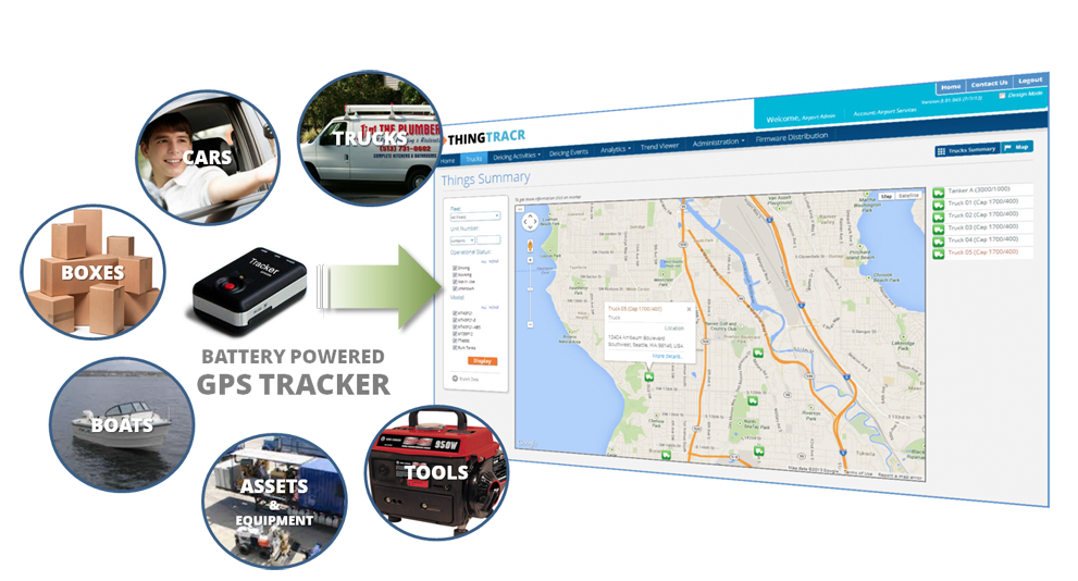
SeeControl is announcing the roll out of ThingTracr, a hosted SaaS GPS tool for monitoring anything that needs to be tracked. The simple-to-use solution offers precise location tracking and historical analytics reporting for things of interest using a small and attachable GPS unit that requires no tools or wiring. The tracking service can be up and running in less than five minutes.
Using web browsers or mobile devices, a user can easily monitor the status of the tracked asset. It can be used for cars, trucks, trailers, packages, site equipment or anything else.
“There are several unique features that set ThingTracr apart from other tracking services,” said Bryan Kester, CEO of SeeControl. “One is a modifiable modern dashboard that allows users to personalize how they view the tracking information in the most convenient way for them. Another is the ability to upgrade and expand to new GPS trackers globally as they come on the market.”
Other features of ThingTracr include:
90-day location history
User customizable dashboards
Low battery alarms
Satellite / hybrid map views
Multiple reports
Data export – CSV/ PDF
Trip Reports
Range of pre-certified hardware
Trip replays on maps
ThingTracr uses various battery-powered GPS devices, which can also notify users of several alarms including motion detected, speeding, and information regarding battery life.
The ThingTracr GPS tracking tool is just one of many vertical solutions available from SeeControl M2M ( Machine 2 Machine ) cloud platform. The ThingTracr solution is available through SeeControl partners including M2M distributors, Network Operators and Systems Integrators.
GRW has purchased an Optech Gemini Airborne Laser Terrain Mapper (ALTM), adding to the company’s full realm of geospatial mapping solutions, including Digital Aerial Photography, Aerial LiDAR, ground-based Stationary Terrestrial Laser Scanning (STLS), and Mobile Terrestrial Laser Scanning (MTLS).
“The Optech Gemini will meet the increased demand for aerial acquisition, providing our clients with the latest advancements in LiDAR technology,” said Jeremy Mullins, CP, GRW’s LiDAR manager. “We have seen a substantial growth in the LiDAR market over the last several years.”
Ben Fister, PE, PLS, PSM, is principal‐in‐charge of the firm’s Geospatial Division. “GRW has always been committed to providing our clients with the best available solutions tailored to their project goals. After careful evaluation, we appreciate the technical advancements that the Optech Gemini has provided in the field of advanced aerial LiDAR solutions. It is a perfect addition to GRW’s arsenal of equipment,” Fister said.
The sensor will be utilized for a variety of projects and industries, including aviation, coal, forestry, transportation, 3D engineering design projects, and related federal, state, and municipal mapping projects.
Plans to reduce funding for GLONASS is causing concern among deputies of the State Duma. The government officials predict a loss of trust in the world by the Russian navigation system, according to a July 29 Roscosmos article.
Reduced funding of GLONASS will lead to a reduction of the orbital grouping system below acceptable levels, according to the first deputy chairman of the Committee on Industry, Vladimir Gutenev. The U.S. GPS system is functioning and both Europe and China are developing systems, Galileo and COMPASS respectively. This will “lead to the loss of confidence of the international community in the GLONASS system and, consequently, to a reduction in its use globally. Russia will lose a strategic global instrument of political and economic prestige,” Gutenev warned.
The proposal is to reduce budget funding of the state space program in 2014 by 11.7 billion rubles, in 2015 by 13.5 billion rubles, and in 2016 by 40 billion rubles, according to the ITAR-TASS news agency. In addition, the federal space program of Russia for 2006-2015 already lacks 10.5 billion rubles funding, and this year there has been a 2.3-billion-ruble additional reduction in R&D.The funding was in part intended to build and put into operation phase 1 of the Vostochny booster side building, which would use the Soyuz-2 space rocket system.
The State Duma, according to the ITAR-TASS news agency, has recommended that the government of the Russian Federation maintains funding of federal programs on space matters in the amount provided by an approved state program.
GPSTrackIt announces new financing options that significantly reduce the initial cost of implementing its Fleet Manager system and GPS tracking devices. The new “No Pay Until 2014” financing plan program postpones hardware payments until January. This includes documentation fees and the monthly payment, reducing the cost of entry to a flat $24.99 per unit for service. This offer applies to deals of $2,500 or more. Credit must approve the transaction and any term length over 36 months.
Also, the Internal Revenue Service’s Section 179 offers tax incentives for businesses, enabling owners to deduct equipment costs and by providing rebates. The deduction limit for Section 179 is now $500,000. The 2013 Section 179 deduction threshold for total amount of equipment that can be purchased is now $2,000,000. Most new and used equipment, as well as some software, qualify for the Section 179 deduction. Only new equipment purchased in 2013 qualifies for the “50% Bonus Depreciation.”
For more information about GPSTrackIt, their new financing options, or their Fleet Manager vehicle tracking system, visit their website at gpstrackit.com.
The Open Source Geospatial Foundation (OSGeo) announced the release of a new stable version of GRASS GIS. This release fixes bugs discovered in 6.4.2 version of the program and adds a number of new features. This release includes over 830 updates to the source code since 6.4.2. As a stable release series, the 6.4 line will enjoy long-term support and incremental enhancements while preserving backwards-compatibility with the entire GRASS 6 line.
According to the announcement, key improvements of this release include some new functionality (assistance for topologically unclean vector data), major speedup for some vector modules, fixes in the vector network modules, fixes for the wxPython based portable graphical interface (attribute table management, wxNVIZ, and Cartographic Composer). A number of new modules have been added for processing LANDSAT and MODIS satellite data, and a new vector statistics module is also introduced. Many new symbols and north arrows are available, and the user will find an improved and easier to use wizard for creating custom project locations with precise map projection and datum support. Community-contributed add-on modules are now more easily and robustly installed from an online archive. Other major developments include enhancements to the Python scripting library and numerous software-compatibility fixes and translation updates. Important is the enhanced portability for MS-Windows (native support, fixes in case of missing system DLLs). And we welcome Romanian as our twenty-fourth language.
Esri released the new version of ArcGIS, marking a major milestone in the history of the Esri platform. With ArcGIS 10.2, Esri has taken advantage of the significant changes in IT that magnify the power and accessibility of GIS. The new release improves ease of use, real-time data access, and integration with existing infrastructure. It allows people to more easily deploy web GIS—the key component for implementing GIS as a platform. Web GIS helps users organize their work and simplifies geographic information discovery, access, sharing, and collaboration.
More Online Analysis Tools
According to the announcement, ArcGIS 10.2 extends the analytic functionality of GIS to everyone via ArcGIS Online. Advanced analysis tools have been added to ArcGIS Online for investigating geographic relationships, patterns, and trends within data. New tools in ArcGIS Online include overlay layers for combining two or more layers into one single layer; enhanced hot-spot analysis; and data enrichment resources to glean information about the people, places, and businesses in a specific area or drive time.
ArcGIS Online Access
To ensure that ArcGIS for Desktop users have access to ArcGIS Online capabilities, Esri entitles every customer organization that has ArcGIS for Desktop (Basic, Standard, or Advanced) to receive an ArcGIS Online subscription. The number of named users will be equal to the total number of ArcGIS for Desktop licenses current on maintenance. This will enable users to easily get started with ArcGIS Online. It will also give access to all Esri apps—such as Esri Maps for Office, Collector for ArcGIS, and Operations Dashboard for ArcGIS—as well as numerous app templates hosted in ArcGIS Online. Esri will notify ArcGIS for Desktop customers about the details of this new entitlement in the coming weeks.
Portal for ArcGIS
At ArcGIS 10.2, Esri gives people the ability to deploy ArcGIS Online capabilities on-premises for tighter content security and control. Portal for ArcGIS provides a secure front end for ArcGIS for Server, with dozens of easy-to-use apps and full integration with ArcGIS for Desktop. It includes geographic viewers and analysis tools designed for people without any GIS knowledge. Experienced GIS users can connect to Portal for ArcGIS from ArcGIS for Desktop, developer APIs, and other Esri applications. The Portal for ArcGIS extension software is included with ArcGIS for Server Advanced (Enterprise or Workgroup) and is licensed and priced based on the number of named users.
Real-Time Data Access
Esri’s new release of ArcGIS introduces a number of new technologies that enable the real-time collection and sharing of data with GIS. It includes ArcGIS GeoEvent Processor for Server, a new ArcGIS for Server extension that gives users the power to access live data streams. People can analyze and send processed results to other users or into other systems. This capability transforms GIS applications into powerful frontline decision tools, refining data quickly for consumption and enabling fast response in any situation.
Expanded Business Intelligence Support
With business intelligence (BI) being relied on even more in an increasingly competitive marketplace, the new ArcGIS release expands Esri’s support for major BI systems. ArcGIS 10.2 includes new MicroStrategy BI and Microsoft Dynamics Customer Relationship Management tools, allowing users of those platforms to perform location analytics on their business data and focus their marketing. Core BI tools Esri Community Analyst and Esri Business Analyst Online also get productivity-enhancing face-lifts and major customization capability.
For more information on the dozens of other improvements in the latest release of ArcGIS, visit esri.com/whatsnew.
It has been a busy month. Apple is getting help turning around its embarrassing mapping debacle with an acquisition of HopStop and Locationary. Latitude, which enables location sharing and check-ins, is being sunsetted by Google, as it adds that functionality to Google Plus. Twitter acquired Spindle to enable real-time location recommendations. Nokia, leading the charge in augmented reality, added LiveSight sight recognition into apps. And mobile advertising, the life blood of many location apps, is exceeding expectations for social media, but is disappointing with mobile search.
In a week when Facebook’ mobile advertising revenue far exceeded analyst expectations and garnered 41 percent of the company’s revenue, Google’s advertising woes are particularly interesting. Second-quarter revenue results from Google indicate that mobile devices are depressing its online advertising prices at a rate greater than expected. Search-ad prices have been declining since late 2011, but Google’s numbers are still surprising low. The average cost-per-click rate, the price Google gets paid by advertisers, is down 6 percent from a year ago. This was double the drop expected by analysts. The decline is due in part from the lower cost-per-click on sites that are accessed from mobile devices than those seen from PCs.
Earlier this year, I wrote about Google’s move to accelerate advertisers’ shift to mobile. The company overhauled its AdWords platform in February in an attempt to reach consumers across all device screens. This required advertisers to pay for mobile ads, even if they only wish to reach consumers via the desktop. Google saw this as a way to more revenue and insisted that an integrated platform would also benefit advertisers. The results have been disappointing and the switch to a mobile world may not be entirely good for Google.
Whatever it Takes. Apple is hard at work overhauling its mapping. Apple has confirmed its acquisition of Locationary and HopStop. Locationary solves the problem of out-of-date points of interest and business data with a platform that collects and verifies crowd-sourced and other data. It also checks the actual physical location of businesses and other places. HopStop offers a door-to-door navigation app that includes transit, walking, biking, and taxi directions in more than 500 cities worldwide.
Tweeting Spindle. Twitter has acquired Spindle, whose mobile search application leverages the social graph to deliver real-time local recommendations. The app harvests social media activity, including location and time of day, and identifies nearby restaurants, retail and other places in the vicinity. In March, Spindle added push notifications based on user preferences. Twitter has closed down the Spindle offering and is certain to repurpose it.
Airport Trip Timing. Traffic is only one of the delays that can be encountered on a trip. Not knowing the expected wait time at airport security frustrates travelers. TripAdvisor has acquired GateGuru to provide security-time estimates, gate locations, and real-time flight status. The company collects information from a mix of user-generated content and data from airports. The offering also includes weather forecasts, detailed maps, and information on terminal amenities.
Augmented Reality at Nokia. Augmented reality (AR) is a leap forward for mapping and is beginning to leave the realm of emerging technology and entering mainstream. Adding AR to maps creates an innate experience in which one can “see” a place with text or a superimposed image. Nokia, a leader in augmented reality, has added LiveSight, an integrated sight recognition technology into the Here suite of apps for some Window phones. Users can enter LiveSight mode, which will scan the surrounding area and pull up relevant information about nearby locations, like addresses, phone numbers, and ratings.Virtual signs are attached to buildings as viewed through the camera display. This can all be accessed off-line.
Augmented Job Searching. One novel app is Nokia’s JobLens, which adds augmented reality to job hunting. Users can visually see jobs around them through the phone’s camera lens. A number of search filters help narrow down jobs, including filtering jobs that have a connection with one’s social networks. JobLens is integrated with LinkedIn, Facebook, Twitter, and Windows Live. Data is provided by partners that include LinkedIn, Indeed, Salary.com and Zillow. When a user finds a job that she wants to apply for, the application will then walk her through the application process and keep track of her progress. Will the job pay in fictitious currency?
Real-time 1-2 meter GPS accuracy in the palm of your hand — a spanking new June T41 rugged handheld computer from Trimble is up for grabs. One lucky winner of the drawing among all entrants who complete the 2013 State of the GNSS Industry Survey will take it home. Other raffle prizes also offered.
In addition to a handheld computer and smartphone configuration, the Juno T41 includes enhanced, real-time 1-2 meter GPS accuracy and high-speed 1D/2D barcode imaging technology.
The 2013 State of the GNSS Industry Survey is going on now at env-gpsworld-integration.kinsta.cloud/State13, until August 10. The survey covers economic outlook, technological frontiers, industry concerns including “The Issue of the Year,” and several questions specific to vertical industry sectors. All those completing the survey will be entered into a drawing to win the Trimble Juno T41.
Prizes. Those completing the survey will be entered into a drawing to win (First Prize) the Trimble Juno T41 rugged computer with GPS; (Second Prize) a pair of tickets to GPS World’s 2013 Leadership Dinner (for those not attending ION, we’ll send a voucher for a comparable dinner in your hometown); (Third Prizes) $50 Mastercard gift cards.
The results will be published as the “State of the Industry Report” in the September issue of GPS World, and analyzed in an August 15 webinar, register here.
New this year, the Survey delves into topics of specific interest to the following industry sectors:
Also new this year, the Survey contains a healthy sampling of questions suggested by participants in the 2012 Survey, in response to “What question(s) do you think it would be interesting and illuminating to ask in the 2013 State of the Industry Survey?”
Note that this is an industry survey, with core questions about business outlook, issues of business concern, revenue ranges, and GNSS products supplied, specified, or purchased. Thus, some GNSS community members from academia or government may find that they cannot answer many of the questions — and a majority of the questions must be answered to qualify for the prize drawing. We regret this — we don’t mean to exclude such members of the community, but in this project our goal is to build a picture of the industry.
The Air Force has issued a Federal Register Notice regarding an upcoming Public Interface Control Working Group (ICWG) meeting, set for September 24-25. Here is the notice:
Public ICWG Announcement—2013
This notice informs the public that the Global Positioning Systems (GPS) Directorate will be hosting a Public Interface Control Working Group (ICWG) meeting for the NAVSTAR GPS public signals in space (SiS) documents and ICD-GPS-870; IS-GPS-200 (Navigation User Interfaces), IS-GPS-705 (User Segment L5 Interfaces), IS-GPS-800 (User Segment L1C Interface), and the Navstar Next Generation GPS Operational Control Segment (OCX) to User Support Community Interfaces (ICD-GPS-870). Dates and times can be found below.
The purpose of this meeting will be twofold: (1) To resolve the comments against the public signals-in-space (SiS) documents with respect to the six issues outlined below, and (2) to collect issues/comments outside the scope of the issues outlined below for analysis and possible integration into the following release. The ICWG is open to the general public. For those who would like to attend and participate in this ICWG meeting, we request that you register no later than August 6, 2013. Please send the registration to [email protected] or [email protected] and provide your name, organization, telephone number, address, and country of citizenship.
Please note that the Directorate’s primary focus will be the disposition of the comments against the following GPS related topics:
1. L1C Week Number of Operation (WNOP)
2. Removal of Obsolete Information from the Public Signals-in-Space (SiS) Documents
3. CNAV Reference Times
4. PRN Mission Assignments 211-1023
5. CNAV Broadcast Intervals
6. Document Baseline for User Community & Zero AOD User Interfaces
All comments must be submitted in Comments Resolution Matrix (CRM) form. These forms along with the Was/Is Matrix, current versions of the documents, and the official meeting notice will be posted at http://www.gps.gov/technical/icwg/.
Comments outside the scope of the above issues will be collected, catalogued, and discussed during the public ICWG as potential inclusions to the version following this release. If accepted, these changes will be processed through the formal Directorate change process for IS-GPS-200, IS-GPS-705, IS-GPS-800, and ICD-GPS-870.
There will also be a special topic that will be discussed at the Public ICWG.
1. Adjacent Band Compatibility (ABC) Study Group Kickoff
Please provide comments in the CRM form and submit to the SMC/GPER mailbox at [email protected] or to Mark Marquez at [email protected] by August 7, 2013.
Public Interface Control Working Group Meeting (ICWG)
Date(s) and Times: 24-25 Sep 2013 (0800-1700) (Pacific Daylight Time P.D.T)
Dial-in Information and Location: 1-800-366-7242, Code: 1528652
Address: SAIC Facility 300 North Sepulveda Blvd, 2nd Floor, Conference Room
2060 El Segundo CA 90245
* Identification will be required at the entrance of the SAIC facility (Passport, state ID, or Federal ID). SAIC Facility phone number: 310-416-8300.
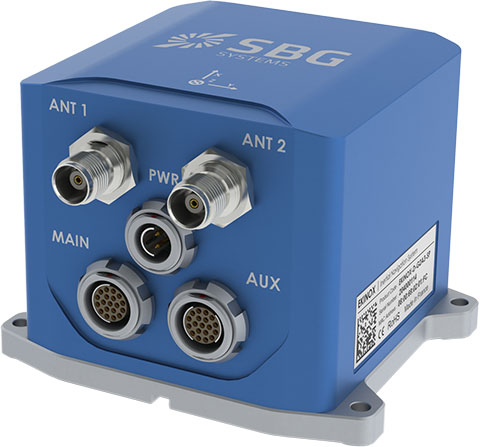
SBG Systems has added a new inertial system to its Ekinox Series. With integrated Dual Antenna GPS + GLONASS receiver, the Ekinox-D is a ready-to-use survey-grade inertial navigation system that provides consistent true heading (0.05°), SBG Systems said.
The Ekinox-D is a high-performance inertial navigation system that embeds a dual-antenna L1/L2 GNSS receiver to deliver more robust heading and position, while increasing satellite reception availability. Ekinox-D is an integrated system: GNSS data and inertial information are fused by an Extended Kalman Filter (EKF) to improve data integrity. This computation allows the system to achieve 0.05° roll, pitch, and true heading; 5-cm heave; and 2-cm RTK GNSS position.
The Ekinox-D is an all-in-one Solution for demanding applications. Instead of mounting separate GNSS receiver and inertial systems on a boat, car, or plane, the Ekinox-D can be installed and connect it to a camera, SONAR, or LiDAR system. With its 8-GB datalogger and its high output rate (200 Hz), Ekinox-D joins simplicity and performance for applications where robust heading is required such as surveying and hydrographic applications, unmanned system navigation, and auto testing.
The IP68 Ekinox Series brings robust, maintenance free, and cost-effective MEMS to the next level thanks to a drastic selection of high-end MEMS sensors, an advanced calibration procedure, and powerful algorithm design, SBG Systems said, adding that compromise is no longer required between high accuracy and cost.
Satelles, a division of iKare Corporation, has entered into a patent and technology license agreement with The Boeing Company. This license allows Satelles to provide timing and location solutions to commercial markets delivered over the Iridium constellation of 66 low-Earth-orbiting satellites.
The timing and location signals are available anywhere on Earth, without the need for local infrastructure, making the system perfect for augmenting GPS and other location-based technologies, Satelles said. Unlike standard GPS, the high-power signals can reach into many building structures. The signal-in-space provides a location-specific signature that can reliably prove (or authenticate) the location of a mobile device or other equipment, while being virtually impervious to spoofing and other attacks, Satelles said.
Gregory Gutt, CEO of iKare Corporation, stated, “After working closely with Boeing for years to create a global indoor-positioning solution, we are thrilled to be entering this license agreement, which includes over 30 issued and pending patents.”
Michael O’Connor, CEO of the Satelles business, agreed. “We see tremendous dual use potential for the technology going forward. Indoor location is an exciting area, and we are seeing keen commercial interest in a solution that delivers trusted location for secure network communication or network transaction security.”
Satelles is headquartered in Silicon Valley, in Redwood City, California, with an office in Ashburn, Virginia.
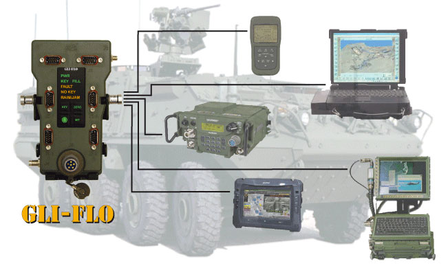
GPS Source announced today that GLI-FLO has been granted security approval by the U.S. Air Force Global Positioning Systems Directorate. The GPS Directorate security approval provides GPS Source with the opportunity to supply military end-users and prime contractors with a DAGR Distributed Device (D3) that meets the mandate for reliability and security, GPS Source said.
GLI-FLO is a secure (ICD-GPS-153 compliant) GPS position, navigation, and timing (PNT) distribution device. One GLI-FLO has the same capability as four DAGRs operating in a platform mounted application (eight DAGRs with custom cabling). GLI-FLO serves ICD-GPS-153 PNT data simultaneously to multiple communication or weapon systems that require GPS information. It routes PNT data while secured in the bracket now used by the DAGR, utilizing standard DAGR accessory cables. When GLI-FLO is connected to one DAGR (or as alternative option, interfaces with an internal secure GPS receiver), secure PNT data can be distributed without the integration of GB-GRAM cards to multiple devices.
GLI-FLO meets the stringent requirements for reliability and security by integrating a GPS Directorate-approved SAASM receiver (Selective Availability/Anti-Spoofing Module). SAASM is the security architecture selected by the Joint Chiefs of Staff (JCS) to provide current security functions for GPS-authorized military users.
“We understand the importance of reliable GPS/PNT data for synchronizing military operations and the need to protect against jamming and/or spoofing,” said Robert Horton, CEO of GPS Source. “We further realize the importance of protecting our national assets by designing products that fully comply with all GPS Directorate security requirements. This security approval makes it possible for our GLI-FLO to be deployed by military forces without reservation.”
In addition to the SAASM compliance, other GLI-FLO features include the ability to serve ICD-GPS-153 PNT data simultaneously to multiple communications or weapon systems that require secure GPS information. It is a significant step for GPS Source toward compliance in GPS Signal Distribution (Single PNT Distribution Point). With zero impact to subscriber application software/hardware, it removes the need to rely on multiple, expensive GB-GRAMS found in military platforms.