Blog

  • The System: Galileo Leaves the Building

    In the early hours of May 15, Galileo’s first full operational capability (FOC) satellite left manufacturer OHB System AG’s integration hall in Bremen, Germany, after successfully completing integration and system testing. Later that same day, it arrived by road at the European Space Agency’s (ESA’s) technical center at Noordwijk in the Netherlands for a rigorous set of tests to check its readiness for launch. The tests will simulate different aspects of launch and space environment. The comprehensive test program will validate the new design and all the FOC satellites to follow.

    This first FOC satellite is functionally identical to the first four in-orbit validation (IOV) satellites already in orbit, but has been built by a separate industrial team. Like the other 21 FOC satellites so far procured by ESA, the satellite’s prime contractor is OHB System AG, and the navigation payload was produced by Surrey Satellite Technology Ltd. in Guildford, UK.

    Thermal vacuum testing at the European Space Research and Technology Centre (ESTEC) will simulate temperature extremes the satellites must endure in the airlessness of space throughout their 12-year working lifetimes. Without any moderating atmosphere, temperatures can shift hundreds of degrees from sunlight to shadow.

    Other activities on the schedule include shaker and acoustic noise testing — simulating the vibration and noise of launch — as well as electromagnetic compatibility and antenna testing, placing the satellite in chambers shielded from all external radio signals to reproduce infinite space and check that its various antennas and electrical systems are interoperable without harmful interference.

    “The Galileo FOC satellites provide the same capabilities as the previous IOV satellites, but with improved performance, such as higher transmit power,” explained Giuliano Gatti, the head of the Galileo Space Segment Procurement Office. “They are to all intents a new design that requires a full checkout before getting the green light for launch.”

    The second FOC flight model is due to arrive at ESTEC in early June, and the third in the middle of July. The first two satellites are to be placed in orbit on board a Soyuz launcher, with a scheduled lift-off from Kourou in French Guyana this fall, with two more due to follow by the end of the year.

    The first four Galileo IOV satellites, launched in 2011 and 2012, were provided by EADS Astrium with Thales Alenia Space Italy responsible for integrating the satellites and Astrium in Portsmouth, UK, providing the navigation payloads. They provided their first navigation fix in March 2013.

    The definition, development and in-orbit validation phases of the Galileo programme are being carried out by ESA and co-funded with the European Commission (EC).

    The subsequent FOC phase is managed and funded by the EC. The commission has delegated the role of design and procurement agent to ESA for the FOC phase. At the same time as the satellites are being assembled on a production-line basis, ground stations are also being established on European territories around the globe.

    Photo credit: Pat Corkery, United Launch Alliance.
    Photo credit: Pat Corkery, United Launch Alliance.

    GPS Leaves This Earth

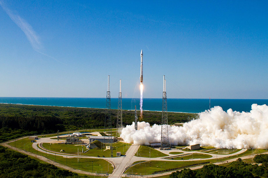
    A t 5:38 p.m. Eastern Daylight Time (21:38 UTC) on May 15,  the fourth GPS IIF satellite, Space Vehicle Number (SVN) 66 built by Boeing, ascended towards orbit aboard a United Launch Alliance Atlas V rocket at from Cape Canaveral Air Force Station, Florida.

    “The GPS constellation remains healthy and continues to meet and exceed the performance standards to which the satellites were built. Our goal is to deliver sustained, reliable GPS capabilities to America’s warfighters, our allies, and civil users around the world, and this is done by maintaining GPS performance, fielding new capabilities and developing more robust modernized capabilities for the future,” said Colonel Bernie Gruber, director of the U.S. Air Force Space and Missile Systems Center’s GPS Directorate.

    The new capabilities of the IIF satellites will provide greater navigational accuracy through improvements in atomic clock technology; a more robust signal for commercial aviation and safety-of-life applications, known as the new third civil signal (L5); and a 12-year design life providing long-term service. These upgrades deliver improved anti-jam capabilities for warfighters and improved security for military and civil users around the world, the Air Force said in a statement.

    The IIF-4 satellite is expected to complete testing in August, after which it will be utilized as a reserve or backup satellite. It becomes the fourth satellite in a 12-strong network of GPS IIF spacecraft manufactured by Boeing as lead contractor, the first of which was boosted into orbit in May 2010. The Air Force expects the first of the next-generation GPS IIIA satellites to enter service sometime in 2014.

    System Briefs

    GLONASS. The GLONASS 747 M-series satellite launched on April 26 has maneuvered into an orbital slot near GLONASS 728, the operational satellite in Plane 1, slot 2. 747 will presumably serve as a reserve until it replaces 728, unless another Plane 1 satellite expires first. The next Russian launch, a GLONASS-M trio, is scheduled for July 1. There are currently 24 operational GLONASS satellites.

    IRNSS. The first Indian Regional Navigation Satellite System satellite is expected to rise at the end of June. The IRNSS plans to orbit of seven: three geostationary and four geosynchronous, providing regional coverage via navigation signals in the L5 and S bands.

  • GPS OCX Ground Control in GAO Report

    A March 2013 report from the Government Accountability Office (GAO) seems to claim that the projected cost of the next-generation GPS ground-control system, known as OCX, increased by 43 percent, or $1 billion over the past year, to a total cost estimate of $3.7 billion. As GPS World contributing editor Don Jewell wrote shortly after the GAO release, “In fact, the report does not actually say that exactly, but you have to dig deep to determine that. Most readers won’t take the time to do that and will assume that the OCX program is grossly over budget. It is not.” A Raytheon spokesperson pointed out that the basis for the program cost estimate goes far beyond the scope of the original 2010 Raytheon prime contract of $886.4 million, and that the current value of the company’s contract is $969 million.

    Design requirements for OCX call for it to support the GPS III constellation’s stringent accuracy, anti-jam, and information assurance requirements. The system is also to be backward-compatible with current GPS satellites. The original contracted carried an initial delivery date of 2016. At least some of the government-specified revisions in the contract come in the context of the need for absolute information assurance, given the Internet- and associated computer program-hacking by foreign sources, considered alongside  the vast user base supplied by GPS, including the U.S. military’s reliance on its capability for many functions.

    Kevin Ramundo, Vice President for Communications, Raytheon Intelligence, Information and Services, commented:

    “GPS modernization through the launch of GPS III satellites and the GPS OCX ground system will provide new mission-critical capabilities to war fighters and additional capacity to meet the needs of millions of additional GPS users each year.

    “Since the initial contract award, Raytheon’s GPS OCX program has made considerable progress including Milestone B approval and the successful completion of two ground station/satellite integration exercises. Nearly 50 percent of the software development is complete.

    “With regard to the GAO report, it is important to note that the basis for their program cost estimate goes far beyond the scope of the Raytheon contract. In 2010, the contract award to Raytheon for GPS OCX was $886 million. The current value of our contract is $969 million, which now includes additional scope such as launch and check-out capability, tech baseline, and special studies.”

    In December 2012, Col. Bernie Gruber of the U.S. Air Force GPS Directorate wrote in the pages of GPS World what was the commonly accepted perception of and public government position on OCX:

    “Along with a host of additional satellite capabilities and signals, we will correspondingly modernize our ground segment. Our Next-Generation Operational Control System (OCX) is designed to command and control our modernized secondary civil signal L2C, safety-of-life signal L5, and the internationally compatible signal L1C.  . . . . . As the modernized signals become operational, users will see faster signal acquisition, enhanced reliability, and a greater operating range. The information assurance, expandability, and service-oriented architecture will afford users and operators with security and information they simply don’t have today.”

    The View from 2013. The 190-page GAO report, “Defense Acquisitions: Assessments of Selected Weapon Programs,” states that the scope and complexity of key OCX program elements was underestimated, and alluded to overruns that have historically beset Pentagon space programs.

    Two of the 190 pages in the report (click here for highlights and to download the full PDF)

    specifically address OCX, which is identified as one of 19 weapons “Programs That Entered Development with Technologies Fully Mature or Nearing Maturity” and one of 14 “Programs with technologies nearing maturity at knowledge point 1 date.” OCX is given a knowledge point 1 date of November 2012.

    According to the Report, “Air Force officials recently stated that, although GPS III is still maintaining an April 2014 “available for launch” date for the first satellite, the planned launch date is being moved to May 2015 in order to synchronize it with the availability of the GPS Operational Control Segment (OCX) Block 0, without which the satellites cannot be launched and checked out.”

    “The program has experienced significant requirements instability and schedule delays while in technology development,” the report reads. “The contractor initially underestimated the scope and complexity of the necessary information assurance requirements which required additional personnel with the necessary expertise and increased government management.”

    Changes in Specifications. In June 2012, a Raytheon executive stated that the OCX contract had been significantly modified, with the addition of a launch and checkout capability that had previously been the responsibility of Boeing, prime contractor on the GPS IIF satellites.

    He also identified information assurance, a primary OCX requirement, as “a big challenge. It is very important that we protect this system against the current and evolving cyber threats because they are real and the nation can’t afford to have this system compromised.”

    An Update Last Autumn. In a November 2012 conversation with GPS World defense editor Don Jewell, Raytheon VP and Program Manager for OCX Ray Kolibaba made the following remarks:

    We currently have 450 people at Raytheon working OCX, and with our subs, an additional 300 personnel. Altogether we have 750 personnel working GPS and OCX issues. This does not include the military and civilian personnel at Air Force Space Command and Space and Missile Systems Center.”

    [ . . . . ]

    Kolibaba-W
    Headshot: Ray Kolibaba

    “Basically we are nearly on cost for the OCX contract. The current contract value is $925M; the original cost estimate was $886M. We are driving forward on that and the Block 1 date or Ready to Operate (RTO) date. Right now, the customer team is working on finalizing a new enterprise schedule that will show the Program Management Directive dates. So, we don’t know the exact date the government envisions. I expect an official date either late this year or early next year. I encourage you to ask Colonel Gruber [U.S. Air Force GPS Directorate] this question, and maybe then we will also get an answer. We have given them our recommendations.

    “Concerning sequestration, I am not worried. I believe we have a reasonable level of support from Congress to maintain and continue OCX. That doesn’t mean something won’t change. Our Washington folks tell us that OCX appears to be on solid footing. The Air Force FY13 Research, Development, Test & Evaluation budget request for OCX, to include Raytheon, support contractors, the GPS Directorate, Federally Funded Research and Development Centers and the like, was $371.6M, and the Continuing Resolution amount was $369.4M — given the current budget environment, that is strong Congressional support.”

    [ . . . . . ]

    “Successful completion of OCX will make a huge difference on a number of fronts. For instance, even though the FAA and DOT don’t have a whole lot of funding to ante up, we are going to make a difference in how they operate in the future. Some actions are transparent, but not all, as we implement their requirements and as we move forward with OCX.

    “The sooner we implement the true capabilities of GPS on airliners and stop adhering only to the fixed air routes, the sooner we will start saving time and money with a vastly more efficient and flexible air routing system.

    “So, from the civil side, there is certainly a difference, and when we bring other signals in they will be key for us, such as L2C, L5, and L1C. We have the solutions to do that with our receivers at this point in time, and I think it is fairly low-risk. Indeed that is probably another of my unofficial milestones.

    “[On] the navigation side, GPS accuracy will noticeably improve, and we will use a new Kalman Filter. We are working the new Kalman filter with ITT Exelis and JPL to enhance capabilities. Couple that with better information assurance, increased integrity and predictability, along with system safety, and you have many of the key differences in the OCS system going forward.

    [  . . . . . . ]

    “We are required to support 40 PRNs at a minimum, with growth potential to 63 PRNs, and we may be able to support more. I’m not sure there is a limit on the system as such.”

    In April of this year, Don Jewell wrote in his Defense PNT e-newsletter column:

    “Most readers [of the report] won’t take the time to [dig deep]  and will assume that the OCX program is grossly over budget. It is not. In fact, to reach that extraordinary number, OCX cost overruns would need to have grown by 43 percent for each year since it was awarded, and that is ludicrous. According to Raytheon VP and OCX Program Manager Ray Kolibaba, the $3.695 billion number probably comes from including “…programmatic costs beyond OCX development costs and pessimistic projections from the government” that in my experience no acquisition agency, nor Congress for that matter, would ever include when determining true program cost adherence parameters.

    Jewell makes the further point that OCX has grown in scope and schedule due in part to government change requests, mainly in the cyber and information assurance areas.

    Where It Stands Now. Notwithstanding the optimism of the Raytheon OCX program manager six months ago, it is reasonable to expect that the GAO estimate of increased cost has drawn Congressional attention, and that in the current fiscal climate, the entire program may once again be imperiled.


  • Aibotix Announces UAV Partnership with Leica Geosystems

    Aibotix GmbH, maker of a new generation of vertical take-off and landing unmanned aerial vehicles (UAV), announced that Leica Geosystems, a global leader in capture, modeling and visualization of 3D spatial information, has licensed the Aibotix X6 for worldwide distribution. Aibotix X6 features advanced, multi-sensor, intelligent guidance systems that make the X6 the safest and easiest to operate commercial UAV.

    AibotX6
    Aibot X6

    According to the announcement, UAVs are becoming increasingly important in many of the applications served by Leica Geosystems’ solutions. These include agriculture, asset & facilities management, cadastral mapping, disaster & emergency management, engineering, environmental, forensics, general industrial, mining, and public safety. Unrestricted positioning of various measuring technologies will spawn new applications as the full potential of this transformative UAV technology unfolds.

    “For many critical applications, access is risky, impossible or simply too time consuming using conventional methods or platforms,” said Rüdiger Wagner, General Manager of Solutions at Leica’sGeospatial Solutions Division. “We chose Aibotix because it is one of the best aerial platforms available for safe, reliable maneuvering of important payloads, not only in tight spaces,” he added. “This UAV mirrors the high standards for which our brand is known, making it the right choice for global distribution now. Going forward, I am confident that Aibotix with their strong product roadmap and skilled team are well positioned to keep leading the market with true innovations. That’s just what we need as we continueto think forward.”

    Joerg Lamprecht, managing director of Aibotix, said, “Leica Geosytems is synonymous with spatial information products, and an ideal partner for distribution of our UAVs. This is exciting teamwork from two companies that deliver pioneering solutions to difficult problems, especially when one has been doing so for nearly 200 years. Existing segments will be benefit and new markets will be discovered as great products from Leica Geosystems reach new heights in more places on Aibotix UAVs.”

    Under this arrangement, Aibotix reports that it remains an independent company with direct sales and additional distribution channels in other markets. Information about Aibotix X6’s performance specifications is available at www.aibotix.com.

  • CNES Computes Real-Time Decimeter-Accuracy Orbits with Galileo

    The first four Galileo satellites used for in-orbit validation were launched in October 2011 and October 2012.They are now transmitting their signals on an operational basis. Thanks to the simultaneous use of these four satellites, the European Space Agency was able to compute the first autonomous Galileo-only fix using broadcast ephemerides in March 2013.

    Using data from the real-time service of the International GNSS Service (as supported by the Multi-GNSS Experiment), real-time protocols and new high-precision multiple signal messages and a new generation multi-constellation network of GNSS stations, the Centre National d’Etudes Spatiales (CNES) has been able for the first time to compute decimeter-accuracy Galileo orbits in real time.

    The networks used in this work include the CNES/Institut Géographique National REGINA (REseau Gnss pour l’Igs et la NAvigation) network and the Deutsches Zentrum für Luft- und Raumfahrt (DLR) and associated organizations CONGO (COoperative Network for GNSS Observation) network (real-time access courtesy of Oliver Montenbruck). The filter used for the multi-constellation real-time orbit determination is a CNES proprietary tool based on a Kalman filter.


    The CNES orbits have been compared to an accurate reference orbit computed by Technical University München (TUM) as part of the MGEX project. The following figure shows the 3D orbit differences for the two solutions (for the ProtoFlight Model (PFM) and Flight Model 2 (FM2) satellites), over the 10 days of the experiment. Excluding the first day during which the filter converges, the 3D root-mean-square orbit difference is about 15 centimeters. This demonstrates the feasibility of accurate real-time Galileo solutions using currently available networks and software tools.


  • OpenGeo Launches Mapmeter Analytics Console

    OpenGeo, a commercial open source geospatial company, launched Mapmeter beta, its server analytics console, while at FOSS4G-North America 2013.

    MapMeter

    According to the announcement, Mapmeter is a full administration and management tool for analyzing GeoServer systems. Formerly dubbed “The Enterprise Console,” Mapmeter sits on top of GeoServer, either within the OpenGeo Suite or standalone, and makes it possible for organizations to monitor production geospatial deployments. OpenGeo’s flagship product, The OpenGeo Suite is commercial open source software that gives customers access, control, customization and more while also providing standards compliance and expert support. With the addition of Mapmeter, spatial monitoring and reporting merge into a complete IT workflow.

    For more information on Mapmeter and the potential of server analytics for spatial deployments, visit Mapmeter.com.

  • Denver Airport Begins Arrivals and Departures with NextGen

    Denver International Airport (DIA) has fully implemented its new arrival and departure procedures, the next phase in the Federal Aviation Administration’s mass overhaul of U.S. airspace, called NextGen. Denver is among the airports at the front end of the adoption process, and is highlighted in an in-depth feature in the Denver Post.

    According to the article, “The recently completed phase at DIA trims arrival and departure fuel costs by eliminating several intermediary steps. The traditional system requires an airplane to come into and out of cruising altitude by firing its thrusters at every new altitude level, wasting hundreds of pounds of fuel… The traveling public will not likely notice an immediate difference in travel time, but proponents hope that the early investment pays off in the end.”

    The FAA predicts that NextGen improvements will reduce flight delays by 38 percent and lead to a 1.4-billion-gallon total reduction of fuel burn by 2020.

  • ST-Ericsson Sells GPS Business to Intel

    ST-Ericsson, a joint venture of STMicroelectronics and Ericsson, has sold its mobile connectivity GNSS business to Intel.

    ST-Ericsson, which focuses on mobile and wireless chips, announced the sale on Tuesday without naming the buyer. An Intel spokesman later said the U.S. chipmaker bought the assets.

    According to ST-Ericsson, the sale “represents another step in the execution of Ericsson’s and ST’s announcement of March 18, 2013,” when the company announced it was winding down the joint venture. Ericsson will assume 1,800 employees and contractors, with the largest concentrations in Sweden, Germany, India and China. ST will assume 950 employees, primarily in France and in Italy.

    In addition to the assets and intellectual property rights associated with this business, 130 employees in Daventry, UK, Bangalore, India, and Singapore are anticipated to join Intel at closing of the transaction, and will be added to Intel’s already-existing GPS assets.

    The closing of the transaction is subject to regulatory approvals and standard conditions and is expected to be completed in August. ST-Ericsson estimates the proceeds from the sale, combined with the avoidance of employee restructuring charges and other related restructuring costs, will reduce the joint venture’s cash needs by approximately $90 million.

    “Today’s transaction validates the leading innovation developed by ST-Ericsson in mobile navigation systems and marks a further important step towards the execution of our shareholders’ decision to exit from ST-Ericsson” commented Carlo Ferro, President and CEO of ST-Ericsson. “I am pleased that this organization will continue to develop leading-edge technologies and delighted that the team found a new home at a leading player in the semiconductor industry.”

  • GIS Cloud Introduces Mobile Data Collection App

    GIS Cloud introduced a  GIS Cloud Mobile Data Collection application for Android and iOS devices. The application is free and available for immediate download on Google Play and Apple’s App Store.

    According to the announcement, GIS Cloud Mobile Data Collection is a tool for today’s mobile devices which enables you to collect data and conduct field surveys faster and easier than ever before. Combined with powerful new custom mobile and web forms, the new Mobile Data Collection app can also be highly tailored for your mobile workforce and a wide variety of applications without any programming.  Many GIS Cloud users have already tested the beta version of the app which helped GIS Cloud to develop a full featured mobile app that suits the need to collaborate across today’s distributed and mobile workforce.The application has been tested across a diverse range of segments including transportation, utilities, municipal and local government, as well as other owners of geo-located assets.

    GISCloudForms

    GIS Cloud reports that the Mobile Data Collection app is a natural extension of the GIS Cloud Enterprise Location App Platform and reflects its commitment to a ‘mobile first’ priority to help enterprises leverage today’s modern computing devices. With the addition of this app, enterprises can instantly create media rich, mobile applications that manage, analyze, share and publish field data and make it instantly available to co-workers on other job sites on tablets, supervisors in the field on laptops, or managers in the office at their desk.

    GIS Cloud Mobile App features:

    • Offline data capture
    • Media (photos & audio) enriched location information
    • Dropdowns, lists, input boxes and comments based on custom forms
    • Review data attributes directly in the app
    • Listen to audio and view images
    • Real time GPS location
    • View and explore maps in the field

    Office app features:

    • Cloud based web apps
    • Custom forms editor
    • Rich GIS symbology and visualization
    • Data editing and exporting
    • One-click map and data sharing
    • Real time collaboration
    • Map publishing
    • Spatial Queries & Analysis
    • Account administration
  • CTIA: Automakers Developing Their Own Infotainment Apps

    OnStar_logo-TBy Janice Partyka

    It’s a trifecta. The most interesting news at CES, Mobile World Congress, and now CTIA was the connected vehicle. Last week at CTIA, the biggest mobile conference in the U.S., GM and OnStar demonstrated ideas of what we can expect in vehicles once AT&T’s LTE network makes its way into vehicles. We heard about many of their concepts in February at Mobile World, but with the infotainment possibilities being shown at CTIA, it is clear the endeavor is evolving quickly. Providers of navigation, mapping, traffic, middleware, search, points of interest and mobile advertising have key roles. We’ll check in ahead with some of these companies.

    GM and OnStar envision an in-vehicle curated app ecosystem with downloadable apps and remote vehicle management. Developers will have access to APIs that can access the vehicle’s speed, performance, GPS, fuel economy and other information, but are kept out of areas that could cause safety issues. GM, as well as other OEMs, is not ready to let the app marketplace take money out of its pocket. The automaker is pushing to get apps built specially for its vehicles. Mary Chan of GM said that the business model hasn’t been decided, but the apps may be free, bundled into a service that GM charges for, or paid out to the developers. Another possibility is an app subscription paid for on a smartphone could be applied to a separate app in the car. We have to wait until model year 2015 to see it come off the assembly line.

    Snippets heard at CTIA:

    “The biggest challenge of indoor location is having a good enough return on investment by the venue.” Derek Peterson, Boingo

    “We hear many pitches from companies that want to supply us with indoor location technology, but so many of them are just unscalable.” David Hildebrandt, ATT

    “Relevant, connected car data trumps free.” Mary Chan, General Motors

    “The future killer mobile apps are banking, retail, medical (records, diagnosis) and government (voting, administrative).” Michael Saylor, MircoStrategy

    “The ownership of data in connected cars will be a huge issue. And what happens to data in a vehicle when you transfer ownership?” Mary Chan, General Motors

    Traffic Information Is Getting Better. Traffic information is getting more granular, hence more useful. INRIX and others are collecting traffic data in road segments about 250 meters long, a significant improvement from the past. Not too long ago, traffic data was provided solely by sensors, cameras and helicopters, which covered only highways and some arterial roads. The use of crowd-sourced traffic data now provides a leap in the amount of traffic data collected, enabling more current traffic conditions, as well more roads, to be monitored. “We can collect traffic data for these small road segments from all sources, crunch it and turn it around in under a minute,” says Bill Schwebel of INRIX.

    How Fast? In a few years, Schwebel says we will see an expansion of navigation that goes beyond driving from point A to point B. This would include accurate estimates of the entire length of your trip, for instance, driving from your home to arriving at your airport gate. “We will be getting more feeds from parking lots with electronic counters, but we can also see the dwell time in a parking lot, or cars that exit without parking, all from crowdsourcing,” adds Schwebel. Waits at TSA lines or rental car counters can be devised using historical and near real-time data. When schedules of events in the area and school calendars are added, the predictions get better.

    Navigation Changes Ahead. Turn-by-turn navigation will take a step forward to becoming more interactive when it becomes a two-way broadcast. Niall Berkery of Telenav, predicts that two-way connected navigation will appear in 2014-2016. “We are now focused on reducing the complexity of navigation and making it more personalized,” says Berkery. The entire industry, hindered by the perspective that navigation is free, is focusing on adding value. Telenav acquired ThinkNear to add hyperlocal marketing to its offering.

    Embedded Navigation and the Delivery Man. Berkery estimates that 30% of navigation systems are embedded in the vehicle, which can makes updating or servicing the devices challenging. Some years ago an interesting solution was developed in China. When an embedded navigation system needed servicing, it was handled by a package delivery service, similar to FedEx. The delivery person manually removed the navigation hard drive from a consumer’s vehicle and sent it off to be fixed or replaced. When the drive came back from the factory, the package delivery person reinstalled it. That’s pretty special service.

    If you missed last week’s CTIA show, held May 21-23 in Las Vegas, you will have to wait a year and a half for its next appearance. With CES and the Mobile World Congress positioned on the calendar prior to CTIA, the other shows drew the lion’s share of product announcements and crowds. CTIA will reposition itself in front of these competing shows. CTIA’s new “Super Mobility Week” will be more international and take the place of the current fall and spring CTIA shows. Super Mobility Week will be held Sept 9-11, 2014 in Las Vegas and will include MobileCON and other major partnerships to create a bigger show experience.

  • Google and Facebook Eye Waze as Potential Purchase

    waze_logoSince the recent CTIA conference wasn’t the buffet of location news, one potential deal could really set the industry on fire going into the summer months. Google and Facebook both are rumored to be in talks to purchase Waze. Some say this would mean Facebook would transform into a mobile advertising company, with local ads, if it were the winning bidder. Google’s rumored interest would block the social media giant’s momentum in that marketplace.

    by Kevin Dennehy

    In what could be one of biggest deals in the location industry, both Google and Facebook have been rumored to be interested in buying Israel-based mapping and navigation company Waze. Published reports indicate the deal could be worth $1 billion.

    Some industry analysts are skeptical that a deal could be valued that high, which would place it in the same realm as Facebook’s $1 billion purchase of photo-sharing service Instagram.

    “We really do not know if Facebook is willing to spend a billion dollars on Waze, but if the deal happens, (Facebook) must have considered its options. How could this be? First, I suspect that Facebook is certain it will grow beyond its current boundaries to become the world’s most valuable company,” said Mike Dobson, Telemapics president. “Operating under this mindset, a billion dollars is peanuts, and they will not care if everyone else thinks they overpaid. In other words, Facebook might not be basing its calculation on the same ‘time-value of money’ that the rest of us are using. Second, if the economics do not really matter to Facebook, the more important question is ‘What advantages would Facebook accrue by acquiring Waze?’”

    Dobson believes that Waze map databases are not competitive with Google or such commercial providers as Nokia or TomTom. “In essence, Waze does not offer competitive map coverage, competitive data quality, competitive data attributing, or a useful source of POI data. More importantly, I suspect that the Waze database will be a major league headache if Facebook plans to use it as the basis for its mapping activities supporting local search,” he said. “Further, I doubt that Waze understands enough about local advertising to help Facebook realize its most important goal of becoming a powerhouse ad agency capable of creating its own captive local search market, comparable or exceeding that enjoyed by Google.”

    Another industry insider, Marc Prioleau of Prioleau Advisors, said that quality and coverage of the maps would make the deal successful — if it really is going to happen. “The rumor mill on Waze seems to be quite active so it is hard to know if there is substance there. Waze has built a very innovative traffic application, and they use the user data to build a digital map data set,” he said. “The value of the company would be tied largely to the quality and coverage of that data set and the perceived ability of a big platform like Facebook to build that out into a truly serviceable worldwide map.”

    Waze is a mapping company built through crowdsourcing map and traffic data over mobile phones, which is the “magic” Dobson believes Facebook finds beguiling about the company.  While Waze claims 45 million users, its active base is more likely around 10-15 million, Dobson said. “Conversely, if you stop to consider the amount of data you could generate if all of Facebook’s mobile users were gathering mapping data through an app built on Waze, then the company might be willing to gamble on the acquisition,” he said. “Providing analytics on the behavior and location of its mobile users to advertisers and other interested parties could be a huge opportunity. On the other hand, there are numerous paths to this endpoint, not just Waze.”

    Dobson said if he were to advise Facebook on the acquisition, a suggested course of action would be that the company write their own crowdsourcing application and build a good quality map database through licensing and direct and indirect map compilation techniques.  “My off-the-cuff estimate is that this could be done for less than the cost of the Waze acquisition. Beating Waze into a quality map database is going to be an expensive — well beyond the acquisition cost — and time consuming effort. Perhaps the most glaring lack in the potential Waze acquisition is the absence of a suitable POI database, which, in my opinion, is the most critical need that Facebook will have in local search.”

    Dobson said he suspects that Facebook’s competitors are not concerned about the company’s potential acquisition of Waze. “Those who already in the mapping business — Google and Apple — will anticipate that it is likely that Waze could become a significant distraction for Facebook and delay the company effectively competing in the local search market. As far as the competitors are concerned, the longer it takes Facebook to mobilize its efforts in local search, the better,” he said. “In business, as in life, strange choices are made. Perhaps Facebook sees a future in Waze that depends on strategies being implemented by the company that we know nothing about. I hope so, as a good dose of innovation is just what the local search market needs.”

    Distinguishing itself is another reason Facebook may be interested in Waze. Providing mapping and traffic capabilities may bring more consumers to its mobile users.

    The company is also is redesigning its mobile pages platform to enable local merchant information, according to published reports. These new improvements may even challenge Foursquare and Yelp.

    There were questions whether the deal with Facebook will go through as published reports indicated that Waze’s research and development activities would remain in Israel rather than go to California, where Facebook’s headquarters are based.

    Google Interested in Waze to Cut off Facebook at the Location Pass?

    The rumor mill is heating up as Internet giant Google and Apple are said to also be interested in Waze.  “I saw a report indicating that Google was interested. If so, it would seem that this would be a move to deny Facebook access to Waze,” Dobson said.  “Google already derives a significant amount of information from passive crowdsourcing — recording the GPS traces of the devices of their users — and I am not sure that the acquisition would provide them any opportunities that they are not already exploiting. Of course, we might remember that Garmin, who had no intention of buying TeleAtlas, made a bid and significantly raised the price that TomTom paid for the mapping company.”

    Other analysts say while there have been several news articles on why Google should buy Waze, it all could be poorly informed speculation. Others say that the Israel tech press is quick to spread rumors. One analyst said, “I hear that the talks are legit, but my guess is that the deal in discussion is not $1 billion.”

  • TeleCommunication System Next Gen 911 First in Production with Carriers

    TeleCommunication Systems (TCS), a provider of mobile communication technology, announced that its TCS VoLTE9-1-1 service is first into production with Tier-1 wireless carriers, including two of the largest North American operators. The fully customizable solution enables 4G/LTE carriers to provide both 911 call routing and originating coarse/precise location information, including the 10-digit callback number, to public safety access points (PSAPs).

    Initially, wireless carriers deployed 4G/LTE solely for data use. Without VoLTE9-1-1 capabilities, carriers must process emergency calls over 3G networks (circuit-switched fallback), even in areas where LTE is deployed. However, with TCS’ VoLTE9-1-1 service, they can now process 911 calls in an all-LTE environment, enabling them to reclaim or reuse 3G spectrum.

    “As carriers increasingly move toward LTE networks, the ability to handle 911 emergency communications is critical,” said Thomas Ginter of TCS. “By leveraging VoLTE9-1-1, network operators are helping to ensure subscribers receive the responsiveness they need in an emergency situation, while expanding coverage to areas where 3G coverage is lacking.”

    TCS VoLTE9-1-1 features:

    • Call routing to the PSAP: The TCS VoLTE9-1-1 service routes a 4G/LTE-originated 911 call using coarse location via the route determination function component.
    • PSAP telecommunicators can call back if disconnected: The TCS VoLTE9-1-1 service remains fully backwards compatible, supporting necessary functions such as providing PSAPs with full 10-digit subscriber callback numbers.
    • Re-bid by a PSAP for precise location after call routing: The location retrieval function allows a wireless carrier complete flexibility in choosing its underlying high-accuracy location technology and supports updated/precise position requests.
    • Emergency voice call continuity for location service: Location continuity and location delivery to the PSAPs are supported in usage scenarios where the 911 call switches from 4G/LTE to 3G/2G networks.
    • Expansion beyond voice: As wireless networks advance, multimedia objects such as text, audio and video can be transferred to a compatible termination point with LTE IP networks, for example, an NG ESINet and i3 PSAP. Leveraging an all-IP network makes it easier and more cost effective to interconnect services.
    • Small cell support: The TCS VoLTE9-1-1 solution supports small cells, including femtocells, microcells, and picocells, which are now commonly used in dense urban, indoor areas and enterprise networks.

    TCS supports half of all U.S. wireless E911 calls, serving more than 140 million wireless and IP-enabled devices.  The company holds more than 280 patents, 43 of which relate to public safety, and more than 360 pending worldwide.

  • u-blox Introduces High-Performance Parallel GPS/GLONASS Module

    Swiss u-blox introduces the surface-mount MAX-M5Q, a compact satellite positioning module that supports GPS and GLONASS, as well as Japanese QZSS satellite GNSS systems. High-performance GPS/GLONASS parallel operation is also supported to enhance positioning speed and accuracy.

    Designed for use in rugged environments and wide temperature range, MAX-M5Q is intended for industrial machine-to-machine (M2M) applications as well as Russia’s ERA-GLONASS emergency call system. MAX-M5Q enhances positioning in poor GNSS satellite visibility conditions as well as in high latitude and polar regions, u-blox said.

    “With parallel GPS/GLONASS operation, MAX-M5Q is able to track all 50 and more U.S. and Russian satellites to deliver incomparable speed, accuracy, and positional availability,” said Thomas Nigg, vice president of Product Marketing at u-blox, “Its compact size and high-reliability makes it an ideal positioning solution for mobile resource management and ERA-GLONASS emergency call applications.”

    With dimensions of 9.7 x 10.1 x 2.5 mm, MAX-M5Q is the newest member of u-blox’ MAX GNSS LCC module series. Additional features include autonomous A-GPS that reduces warm start TTFF by as much as 90%, and an embedded data logger which can store location information to internal Flash memory for up to 16 hours at 15 second intervals.