Hemisphere GNSS has rolled out the R330 GNSS receiver, a versatile, fully featured positioning system. R330 delivers accurate and robust positioning through a variety of differential correction methods including SBAS, L-Band, Beacon and RTK, the company said. With its wide range of functionality and ease of use, the R330 is suitable for a variety of land and marine applications.
The R330 GNSS receiver combines the functionality and front panel display of all previous R-series products. Customers can start with sub-meter positioning accuracy and upgrade the receiver with subscriptions that add functionality and improves performance capability to centimeter-level accuracy. To provide the most reliable solutions, R330 is capable of tracking multiple frequencies and multiple constellations including GPS and GLONASS. Users can easily switch between the various DGPS correction options without any downtime. The R330 GNSS receiver is compatible with many of the Hemisphere GNSS’ multi-frequency antennas.
The small, rugged receiver includes a display and status indicators for a user-friendly experience, Hemisphere GNSS said. A standard USB flash drive can be used for data logging.
“The functionality and performance of the R330 receiver can be custom-fit to positioning applications such as pipeline, marine, and volumetric surveys, GIS mapping, vehicle tracking, machine control, meter monitoring and many others,” said Ron Ramsaran, senior product marketing manager at Hemisphere GNSS. “R330 customers will benefit from the reliability, value, and upgrade options that can be added to meet changing needs.”
R330 features Hemisphere GNSS’ exclusive Eclipse SureTrack technology, enabling a more robust RTK solution with fewer dropouts in congested environments and a fast reacquisition when dropouts do occur. Long-range RTK baselines of up to 50 km are achievable with R330.
The R330 GNSS receiver will be available in June through the Hemisphere GNSS Precision Products global dealer network.
ITT Exelis announced it will make its Jagwire solution for the management and dissemination of tactical imagery and video available on a mobile platform. Jagwire Mobile allows users, such as soldiers operating in environments where bandwidth is limited, to capture, process and rapidly access imagery and data from remote networks.
“Exelis is a global leader in allowing our customers to move beyond mere image acquisition and into image interchange and true knowledge sharing,” said Jim Phillips, director of the Exelis geospatial intelligence solutions business area. “The Exelis Jagwire solution provides warfighters one seamless user interface to search, discover and exploit still imagery, wide-area motion imagery and full-motion video, which improves decision making and response when seconds are critical.”
According to the announcement, the Jagwire Mobile solution offers much of the same functionality of the Jagwire enterprise version, which is important for users in bandwidth-constricted or hostile areas. Taking advantage of advanced data compression techniques, Jagwire Mobile allows video and image capture as well as processing into the Jagwire repository where the imagery is indexed and becomes searchable by other users on shared networks. The mobile version of Jagwire supports Android 4.1.1 and higher. Support for iOS 6 and HTML5 will be available later this year.
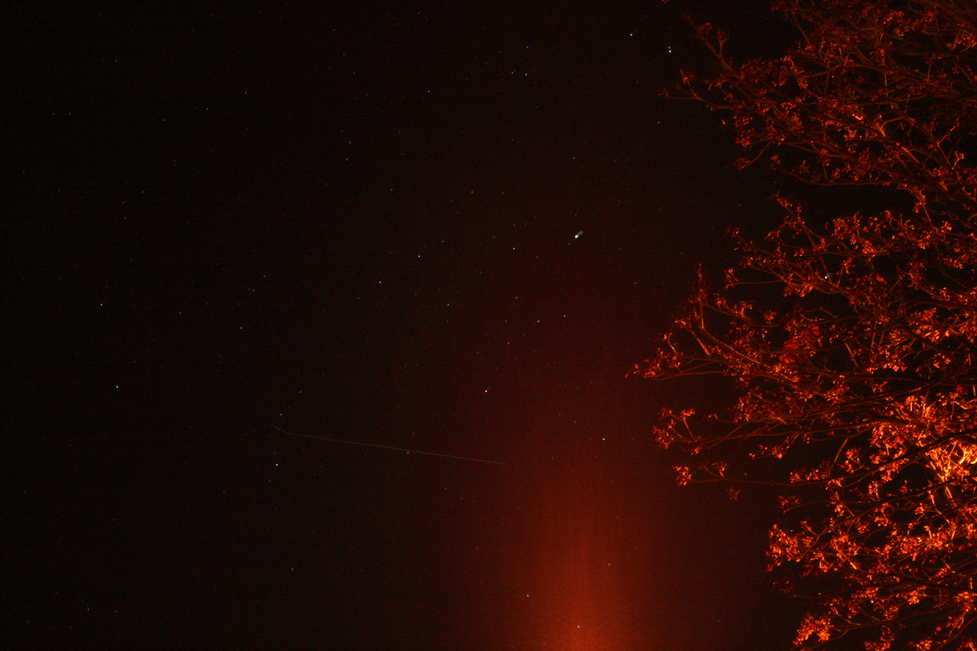
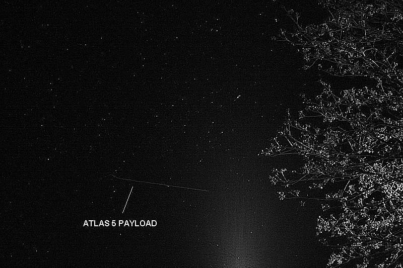
UPDATE, May 24, by Richard Langley: The Centaur upper stage with the payload still attached was photographed from Tavistock, Devon, in the U.K. by Andy Smith. As can be seen from the ground trace figure in an earlier GPS World news item, the Centaur passed over the U.K. following MECO1, the first main engine cutoff. From Europe, the Centaur could be easily seen by reflected sunlight against the background stars. Its maximum (apparent) brightness magnitude has been estimated as -1 or -2. (Sirius, the brightest star in the night sky, has a magnitude of -1.5; Betelgeuse in the constellation Orion has a mean magnitude of about 0.4; and the limiting visual magnitude for the unaided eye is about 6.)
Smith’s photograph was taken at 21:58:38 UTC (start) with a Canon EOS 450D Digital Rebel camera with an 18-55mm zoom lens. The camera settings were: focal length 55mm, aperture f/5.6, and an exposure of 8 seconds at an ISO value of 1600. Two images are shown below: the original, as obtained from the camera, and a greyscale image with edge enhancement.
The Centaur can be seen traveling left to right and starts its track as it crosses the constellation of Cygnus. There’s a slight wobble at the beginning as the shutter release was pressed. The glow at the bottom of the frame is from a streetlight. The elevation angle of the Centaur was approximately 12 degrees.
SVN66 will operate as PRN27 and it will eventually occupy the C-2 orbital slot, replacing SVN33/PRN03, a Block IIA satellite launched in 1996. SVN66 is currently in a drift orbit about 400 kilometers above the operational constellation. It should reach the C-2 slot within a few days from now. The satellite has already been added to the broadcast almanac although it has not yet started to transmit standard signals. It is currently marked as unhealthy in the almanac and will remain so, even after standard signals are switched on, until testing is completed sometime this summer.
Centaur upper stage with the payload still attached, original photo. Photo credit: Andy Smith
The same photo digitally enhanced:
Digitally enhanced photo. Photo credit: Andy SmithPhoto credit: Pat Corkery, United Launch Alliance.
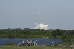
A U.S. Air Force Global Positioning System satellite built by Boeing was successfully launched May 15. The fourth GPS IIF satellite, Space Vehicle Number (SVN) 66, was carried aboard a United Launch Alliance Atlas V Launch Vehicle at 5:38 p.m. EDT (21:38 UTC) May 15 from Cape Canaveral Air Force Station, Florida.
The new capabilities of the IIF satellites will provide greater navigational accuracy through improvements in atomic clock technology; a more robust signal for commercial aviation and safety-of-life applications, known as the new third civil signal (L5); and a 12-year design life providing long-term service. These upgrades improved anti-jam capabilities for the warfighter and improved security for military and civil users around the world, the Air Force said in a statement.
“I’m extremely pleased with today’s launch and delighted to be part of this mission that enhances our nation’s critical GPS capability. Thanks to the superb efforts of the of the 45th and 50th Space Wings, United Launch Alliance, our industry partners, the Atlas V and GPS IIF launch teams, the GPS IIF-4 mission was successfully carried out,” said Col. Bernie Gruber, director of the Space and Missile Systems Center’s Global Positioning Systems Directorate.
“The GPS constellation remains healthy and continues to meet and exceed the performance standards to which the satellites were built. Our goal is to deliver sustained, reliable GPS capabilities to America’s warfighters, our allies and civil users around the world, and this is done by maintaining GPS performance, fielding new capabilities and developing more robust modernized capabilities for the future,” said Colonel Gruber.
Here are videos of the launch:
Opening photo by Pat Corkery, United Launch Alliance.
Photos show the launch of the U.S. Air Force’s GPS IIF-4 satellite from the Kennedy Space Center and Cape Canaveral Air Force Station.
Photo credit: Stephen Clark/Spaceflight Now
Photo credit: Stephen Clark/Spaceflight Now
Photo credit: Pat Corkery, United Launch Alliance.
Photo credit: Walter Scriptunas II/Spaceflight Now
Photo credit: Walter Scriptunas II/Spaceflight Now
Photo credit: Walter Scriptunas II/Spaceflight Now
Photo credit: Pat Corkery, United Launch Alliance.
Photo credit: Walter Scriptunas II/Spaceflight Now
The chief designer of the BeiDou Navigation Satellite System said China will advocate the use of the system, which will be compatible with new devices, “so that Beidou can function properly and independently even if something goes wrong with the GPS.”
Sun Jiadong, chief designer of BDS and an academician of the Chinese Academy of Sciences, made his comments in an interview with The Beijing News, as reported by the Chinese government’s website.
He added that this compatibility is the only way to ensure the protection of national information. “Safety issues abound in economic areas,” said Sun. “Ordinary people may have few concerns about the security of information but it is of vital significance.”
The development of Beidou also largely depends on the government’s involvement. “Even though the enterprises spare no effort in developing the system, the products they make would not be available for mass production, which will in turn be reflected by the prices. The government has to promote the research and development of the system,” Sun said. Sun cited the governments of Beijing, Shanghai, and Guangzhou as examples of local governments that were effectively helping to develop the BDS.
The use of Beidou could go beyond basic navigation functions and extend to the civilian market. It would take longer for the BDS to be available for civilians, said Sun. The use of Beidou on mobile phones relies on the development of a small and power-efficient chip. Otherwise the phone cannot be used.
When asked about when and how the cost of developing the BDS will be recovered, Sun reiterated that Beidou was developed to ensure the security of national information, and not to make profits.
The Beidou global navigation system will be available by 2020 with the launching of more than 30 satellites.
The fourth International Colloquium on Scientific and Fundamental Aspects of the Galileo Programme will be held in Prague, Czech Republic, December 4–6.
Since 2007, the worldwide scientific community has met every two years to discuss the possibilities for boosting the scientific use of Galileo and for contributing to the development of the GNSS.
The event is always organized in one of the 20 European Space Agency’s Member States, and makes an essential contribution to ESA’s implementation and definition of the evolution of the European GNSS. The gathering of major academic players provides a scientific reference for institutional executives and industry, as well as offering a unique platform for promoting innovative GNSS initiatives at large.
The colloquium focuses on four major areas of research:
Scientific applications in meteorology, geodesy, geophysics, space physics, oceanography, land surface and ecosystem studies, using either direct or reflected signals, differential measurements, phase measurements, radio occultation measurements, using receivers placed on the ground, in aircraft or on satellites.
Scientific developments in physics, dealing with future GNSS, particularly in testing fundamental laws in astronomy and in quantum communication. Relativistic reference frames and relativistic positioning will be addressed.
Aspects of metrology such as reference frames, onboard and ground clocks, and precise orbit determination.
Scientific aspects of satellite navigation and positioning such as signal propagation, tropospheric and ionospheric corrections and the means to model and mitigate multipath and interference.
The various possibilities to use navigation satellites such as Galileo for scientific purposes will be reviewed and the use of scientific applications to contribute to make the most of the present systems and define their evolution will be scrutinized.
The conference is being organized as a series of plenary talks and two parallel half-day sessions.
Online submission of abstracts is open until June 14 through the colloquium website, where other detailed information is also available.
The gvSIG Community introduced a gvSIG 2.0 extension that allows access to OpenStreetMap (OSM) layers.
According to the announcement, for installing this plug-in, the user must open the Add-ons Manager in gvSIG 2.0 and select the “By URL” option and “http://downloads.gvsig.org/download/gvsig-desktop/“. The user must select the “Formats: OpenStreetMap raster tiles support” package. In the next few days, the link will be available on the other gvSIG repositories.
The plug-in includes basic access to the OSM layers for viewing. There are four servers configured by default that show the Map Quest, Map Quest Open Aerial, Open cycle Map and Mapnik layers. In the “Add layer” interface it is possible to add new servers.
Trimble introduced SketchUp 2013, the latest version of the 3D modeling platform used by millions around the world, including architects, engineers, building and design professionals and members of the fast-growing maker community. Featuring new capabilities for professional users, an Extension Warehouse for add-on tools and a rebranding of the software’s free version as SketchUp Make, the new release marks the first major update since Trimble’s acquisition of SketchUp from Google in April 2012. The enhancements underscore SketchUp’s strategic value as part of Trimble Buildings, a group formed in 2012 to offer hardware, software and service offerings for streamlined communication throughout the Design-Build-Operate (DBO) lifecycle of construction.
“Trimble has always recognized that one of the biggest challenges facing the construction industry today is ensuring effective, clear and consistent collaboration between professionals involved in all phases of a construction project,” said Chris Keating, director of Trimble Buildings’ Architecture Division. “SketchUp is an important tool to address this industry need. That’s why Trimble has already implemented several SketchUp integrations with Trimble’s data modeling and project management tools. SketchUp 2013 marks the first step in a continuous technology investment that will benefit SketchUp’s existing user community and other Trimble customers across the construction industry.”
According to the announcement, SketchUp Pro 2013 provides professional users with more powerful tools to easily explore, modify and share design ideas in 3D. As in previous versions, users can quickly design and visualize in 3D, import CAD plans, photos, aerial imagery, and then use SketchUp Pro’s documentation tools to develop communication and planning deliverables. For example, architects can quickly evolve design ideas and document modeling work to reflect changing project requirements. SketchUp Pro also enables engineers, general contractors and building owners to drive design discussions and generate commercial deliverables such as conceptual estimates, construction drawings, RFI’s and full-screen digital presentations.
The new release includes several improvements to SketchUp Pro’s 2D documentation capabilities, including enhanced vector drawing tools, faster rendering and zooming, and customizable hatching styles. These updates make SketchUp Pro more powerful, precise and customizable for detailing, dimensioning and organizing models in professional documents.
In addition to serving the commercial market with SketchUp Pro, Trimble will continue to provide a free, entry-level, 3D drawing tool—now named SketchUp Make—enabling makers and hobbyists of all kinds to bring their ideas to life.
The company reports that since 2004, third-party developers have been using SketchUp’s open and free API to build custom tools for SketchUp users. This plugin ecosystem grew throughout SketchUp’s years at Google and now—in Trimble’s first update—dedicated developers and their valuable modeling tools finally have a home within SketchUp. The Extension Warehouse makes it easier than ever for users to search, find and install SketchUp extensions. As developers begin using the Extension Warehouse to manage, market and support their extensions, SketchUp users can expect to have easy access to more and more task-specific tools.
“We may have changed companies, but our commitment to delivering smart and efficient design tools is stronger than ever,” said John Bacus, director of SketchUp product management at Trimble. “We noticed that a big percentage of our professional users were using plugins, so part of making SketchUp more efficient is making it easier for them to find the tools they need, when they need them. We often say that SketchUp is better off because of the work done by our developer communitynow, SketchUp users are better off too.”
This is Part 2 of the discussion I started in March with this article. It frames this discussion.
I ended Part 1 of this discussion with a statement from Michael Dennis of the U.S. National Geodetic Survey. He said while people understand that the 14-parameter transformation algorithm is important in transformations between horizontal datums, the step people are leaving out is reconciling epoch dates of the data.
What is an epoch date?
The epoch date is simply the date in which geospatial data is referenced. It can be the date the data was collected or a standardized date. For example, the current NAD83 (North American Datum of 1983) datum has a standardized epoch date of 2010.0 (January 1, 2010).
Why do we care about the epoch date of geospatial data?
It can be overwhelming to think about trying to populate and manage a centimeter-level GIS, and even more unfathomable when one considers the fact is that the land we occupy is moving. Some refer to it as continental drift. Scientists refer to it as tectonic plate movement. Geodesists refer to it as velocity. No matter which term you use to describe the phenomenon, it’s something that we, as geospatial practioners, need to reconcile. For example, the islands of Hawaii “move” horizontally about 6 cm/year. If you collected GPS data in 2005 using WAAS as a source of GPS corrections, WAAS base stations were referenced to ITRF00 epoch 1997.0. In 2013, WAAS is now referenced to ITRF08 with an epoch of 2013.5. If you collected data today and compared the two coordinates, you would introduce 99 cm of horizontal error (16.5 years x 6 cm/yr) if you did not take into account the movement and epoch date. Other geographic regions don’t move as much, but even the most stable plates still move. Following is a map of the tectonic plates of the world.
Worldwide Map of Tectonic Plates. Source: University of Kentucky
Each tectonic plate moves, and with the large number of stationary GPS/GNSS receivers (CORS) located around the world, scientists can closely monitor (and model) the movement. Following is a general map of worldwide velocities. Higher resolution velocity maps for many geographic regions are available from local agencies:
Rough, Worldwide Velocity Model. Source: University of Kentucky
Finally, if you’re looking for further reading on tectonic plate theory, take a look at these websites:
In order to properly capture a location of a point on the Earth and be able to accurately (within centimeters) return to that location in the future, it’s critical that the “epoch date” of the location be recorded along with the x, y and z. In the future, when you’re preparing to relocate or return to the location, you’ll need to bring the coordinates to the same epoch date prior to comparing them. Perhaps it’s best to use an example to explain.
A few weeks ago, I was in Colorado and wanted to test the accuracy of a free CORS Streaming service (RTK) using a dual-frequency GNSS receiver. I was just outside of the city of Boulder. I located a nearby survey mark that had recently been surveyed using a high-precision GNSS receiver and adjusted to the National Spatial Reference System (NSRS). Following is a photograph of the survey mark I found:
National Geodetic Survey Mark KK2060.
I downloaded the survey mark datasheet from here on the National Geodetic Survey website. What pieces of information do I need in order to accurately compared the NSRS coordinates of the survey mark with the coordinates being determined by the GNSS receiver? Certainly, I needed the coordinate and the datum the coordinate is referenced to. In this case, the following datasheet tells me the datum is NAD83/2011 (North American Datum of 1983 Ver. 2011). The other critical piece of information is the epoch date, which is clearly noted on the datasheet as highlighted below, epoch 2010.0 (January 1, 2010).
National Geodetic Survey (NGS) Datasheet for KK2060.
Since I have all the information about the survey mark that I need, I turn my attention to the GNSS receiver. Actually, the GNSS receiver doesn’t determine which datum/epoch date the GNSS receiver provides. In reality, it depends on the datum the GNSS base station data is referenced to. For example, if you’re using a state-government-operated RTK Network, the datum is likely NAD83/2011. If you’re using OmniSTAR real-time corrections, the datum is ITRF08/epoch 2010.0. If you’re using Starfire real-time corrections, the datum is ITRF05, and the epoch date is updated nightly. WAAS (SBAS) uses ITRF08 and updates the epoch approximately annually, so the current epoch is 2013.5. These are just a few examples. There are many possible datum that the GNSS base station can be referenced to.
In my case, I was using a streaming RTK data (over the Internet) from a public RTK base station 18 km away. I was able to connect to the RTK base station over the Internet and obtain a real-time, centimeter-level coordinate in ArcPad:
ArcPad GPS Data Quality Tab. In the ArcPad screenshot, the EPE, HPE, VPE values show 0.0, but that’s only because there aren’t enough digits of precision to show the 1-cm estimated accuracy.
In speaking to the administrator of the public RTK base station, I learned the RTK base station was referenced to ITRF00, epoch 1997.0. That means the coordinate my GNSS receiver was displaying in ArcPad was referenced to ITRF00, epoch 1997.0. If I’m going to accurately compare the coordinate of the NGS survey mark and the GNSS data I’m collecting, I going to need to adjust the ITRF00, epoch 1997.0 coordinate data to NAD83/2011. If I only adjusted the ITRF00 datum to NAD83/2011 and ignored the epoch date of the data, I would be ignoring 14 years of tectonic plate movement. If the tectonic plate movement is 2 cm/year, not reconciling the epoch date could introduce 28 cm of error, which is a lot considering I’m using RTK GNSS equipment capable of 1-2 cm precision.
Which software tool should you use to reconcile the datums and epoch dates? That’s the biggest challenge our industry faces today.
Very few GIS software and data collection software handle datums and epoch dates correctly. That’s a subject for the next article in this series.
If you’ve been interested in my two articles on this subject, you might want to attend a webinar I’m conducting to be held June 20, 10:00am Pacific time. I’ve lined up world-class panel members to join me in an in-depth discussion on this subject.
An introduction to the challenge of dealing with disparate horizontal datums in your GIS. We are moving into a new era in dealing with datum transformations. Geodata 2.0 is coming, and it creates big headaches when imported into existing geospatial databases. Sensors such as GPS receivers and satellite imagery provide much more accurate (centimeter-level) data, setting up a collision with outdated and mismatched legacy horizontal datums.
Moderator: Eric Gakstatter
Speakers:
Kevin Kelly, Geodesist, Esri
Michael Dennis, National Geodetic Survey
Craig Greenwald, Mobile GIS Consultant, GeoMobile Innovations Inc.
1Spatial has launched 1Edit, a touchscreen compatible solution that offers fast and intuitive data-editing in the field or office, 1Spatial said.
Trialed by Ordnance Survey Ireland (OSi), 1Edit incorporates a touchscreen for capture and editing of real-world data, making it a breakthrough for data collection in the field via touchscreen, stylus and survey devices, 1Spatial said. It can also be used in an office environment with mouse and keyboard. 1Edit’s “in the field” capabilities will benefit spatial data providers and industries such as utilities, transport, environment and government, the company said.
“Ordnance Survey Ireland has been trialling 1Edit as a tool for maintenance of our PRIME2 product database,” said Lorraine McNerney, Spatial Data and Infrastructure Manager, Ordnance Survey Ireland. “PRIME2 is the OSi real-world feature database that ensures Ireland has accurate and up-to-date spatial datasets supporting improved government service delivery and economic development in Ireland. The facility for users to interact with 1Edit using a portable device touch screen with a stylus or as a desktop with a mouse, and the integration it provides with our existing survey equipment means that our surveyors out in the field and staff who are office based can utilise the same innovative tool for optimal efficiency. This means that we will be able to provide more accurate and up-to-date data to our customers more frequently.”
1Edit provides fast and accurate topological editing to keep data connected, 1Spatial said. It allows change-only saving of data and supports rich real-world hierarchical data models, as well as intelligent management of inter-feature references. 1Edit is currently available on Windows 8 with other operating systems to follow.
“We are delighted to launch 1Edit, which offers a powerful, fast and accurate tool to effectively manage real-world data,” said Marcus Hanke, CEO, 1Spatial. “1Edit maximises data output, because the touch screen capability means that whether organisations are using 1Edit on location or in the office, they will be able to use the same tool to edit information quickly and easily, saving them time and money on data capture. Organizations can also use aerial imagery or survey devices to ensure the quality and accuracy of the data they create and manage.”
skobbler brings together hybrid online and offline worldwide maps and full turn-by-turn navigation in a low-priced app with the launch of GPS Navigation & Maps for Android.
skobbler is looking to exploit the weaknesses of established Android navigation alternatives with the fully featured GPS Navigation & Maps, which offers an improved experience compared to both Google Maps and high-priced third-party alternatives, skobbler said. GPS Navigation & Maps is effectively two apps in one, with both online and offline turn-by-turn navigation and digital mapping for smartphones.
Using open-source digital map OpenStreetMap and powered by the skobbler NGx map engine, GPS Navigation and Maps has full online and offline capability. The £1 price includes worldwide online functionality as well as an installable map of one country of choice for offline use. From here, users have the option to in-app purchase individual cities, states, countries and continents to use offline, and worldwide maps are available as standard for online use. Existing users of ForeverMap 2 will receive a free upgrade to GPS Navigation & Maps. New users can either purchase the full app or try GPS Navigation & Maps’ free app with unlimited online functionality and a 14-day navigation trial.
While Google Maps is free to download and use, its offline functionality is restricted. Users cannot perform any searching or routing tasks without an Internet connection, which means that when abroad or in low signal areas they either have to pay expensive roaming costs or spend a significant time without map coverage, limiting its usability while traveling, skobbler said. Expensive alternatives such as Co-Pilot Live or TomTom UK & Ireland/Europe do offer premium features and offline navigation, yet none of them give users a choice of which areas they want to use online and which offline. Most premium sat nav apps generally cannot be used as travel apps at all, as their pure map functionalities are limited at best. GPS Navigation & Maps is the perfect blend. Offering the best of both worlds for a fraction of the price, it can be relied upon to deliver any place, at any time, and being two great apps in one offers a fantastic cost-to-benefit ratio and unbeatable flexibility for consumers, skobbler said. Individuals can build their own navigation and maps app depending on what resources they use the most, and more effectively manage the limited storage space on their devices, skobbler said.
GPS Navigation and Maps has full turn-by-turn navigation, worldwide mapping and all features of the software accessible both online or offline. This unique move, and market first, is made possible thanks to skobbler’s NGx map engine, which delivers a seamless browsing experience with ultrafast real-time rendering and stunning map visuals, skobbler said. NGx also offers a range of unique map styles to, for example, accentuate color density for outdoor use to improve clarity. Maps are highly customizable with control over features such as online/offline functionality, map display (style and zoom), routing, map matching and more.
“We’re very proud to launch the first navigation product utilising our powerful NGx mapping engine,” said skobbler CTO Philipp Kandal. “Being the first and only company on the Android platform to offer full online and offline capability for both mapping and navigation, we hope both new users and our existing customers will be won over by the high performance and flexibility GPS Navigation & Maps offers. We’re already working on future updates and have a few powerful additions lined up to improve the app’s functionality and flexibility even further in the coming months.”
Additional maps beyond the free map provided will be available via in-app purchases for offline use. In keeping with the low price for the initial app purchase, add-ons are similary competitive and are priced at £0.77 for cities, £1.11 for states, £2.22 for a whole country, £4.44 for a continent and just £7.77 for the entire planet, so users can quickly and easily supplement their map coverage as they see fit.
skobbler is committed to providing regular updates to users to keep maps fresh and accurate, and promises a range of new premium features in future updates. GPS Navigation & Maps is now available from the Google Play Store, with existing ForeverMap 2 users able to upgrade for free.
The full version of GPS Navigation & Maps, including one free offline country map, can be downloaded.
Accord Technology’s NexNav GPS receiver will be supporting FreeFlight Systems with its recently awarded FAA Capstone Retrofit Project. In March 2013, FreeFlight and Accord announced their collaboration to develop practical and cost-effective ARINC 429 WAAS GPS solutions that enable aircraft operators to meet ADS-B, RNP (0.3) and other performance-based navigation mandates, worldwide.
The NexNav Circuit Card Assembly (CCA) will integrate with FreeFlight’s upgraded automatic dependent surveillance-broadcast (ADS-B) avionics to fulfill the requirements of the second phase of the FAA Capstone Project.
“This is an excellent example of how we are working closely with FreeFlight Systems to create state-of-the-art NextGen solutions that are not only meeting upcoming mandate requirements but doing it in a cost effective manner,” stated Hal Adams, Chief Operating Officer for Accord Technology, LLC.
The Accord Technology NexNav product line revolves around two key receivers, NexNav mini and NexNav MAX. The receivers are at the heart of embedded customer solutions whether as a Circuit Card Assembly (CCA) or embedded in the Line Replacement Unit (LRU) as a stand-alone GPS solution.
NexNav mini was the industry’s first GPS receiver and sensor qualified to fully support the known worldwide and U.S. FAA ADS-B GPS source requirements The NexNav mini and MAX are compatible with EGNOS and other Satellite Based Augmentation Systems (SBAS) to the extent they are is compatible with WAAS.
Avenza Systems Inc., producers of MAPublisher cartographic software for Adobe Illustrator and the PDF Maps mobile app, announces the release of Geographic Imager 4.2 for Adobe Photoshop. New formats are supported, including writing to the DEM TIFF format which saves raw DEM values and exporting web tiles to Google Maps or Microsoft Bing Maps format.
This release is available at the Geographic Imager Basic license level which provides support for the geospatial framework in Adobe Photoshop as well as limited import and export abilities at an introductory price level. Also new in this release is the addition of the Georeference feature with the Geographic Imager Basic license.
“We’ve been working on some very innovative features lately, one of them being the ability to export web tiles using Geographic Imager from Adobe Photoshop,” said Ted Florence, President of Avenza. “The web tiles are compatible with several online map services which allows our users to spend less time worrying about image referencing and more time creating online mapping solutions,“ he added. “Another great feature in this release is the new ability to save to the DEM TIFF format, which is interoperable and can be reopened in Geographic Imager or in other geospatial software packages. There has been a demand for extended format support and we’re continuing to listen to our users’ needs.”
Features:
Available Geographic Imager Basic license
DEM TIFF write support, format saves raw DEM values
Ability to Export Web Tiles to Google Maps or Microsoft Bing Maps format
Geographic Imager panel improvements, including new Survey and Ruler tabs
Crop by Vector File Extents, use the geographic extents of a vector file to crop an image
Streamlined user interactions with command boxes and simpler messages
Various bug fixes and user experience enhancements.
Geographic Imager is software for Adobe Photoshop that leverages the superior image editing capabilities of raster-based image editing software and transforms it into a powerful geospatial imagery editing tool, Avenza said. Work with satellite imagery, aerial photography, orthophotos, and DEMs in GeoTIFF and other major GIS image formats using Adobe Photoshop features such as transparencies, filters, and image adjustments while maintaining georeferencing and support for hundreds of coordinate systems and projections.
Geographic Imager 4.2 is immediately available and free of charge to all Geographic Imager Maintenance Program members and at US$319 for non-maintenance upgrades. New fixed licenses start at US$699. Geographic Imager Basic licenses start at US$199. Academic and volume license pricing are also available. Geographic Imager 4.2 is compatible with Adobe Photoshop CS5, CS5.1 and CS6. Visit www.avenza.com/geographic-imager for more information.