GIS is a platform for understanding our world. In the past, the data that fueled GIS was typically created to represent the state of the geoscape at a specific moment in time (“historic” or “current”; or “future” to represent a future modeled state). While this data has proven valuable for countless GIS applications and analyses, even the “current” snapshot falls out of sync with the real world quickly. In today’s fast-paced, constantly changing world, the “current” snapshot is outdated almost as soon as it is created.
A number of new technologies are combining to enable the real time collection of data, and the sharing of that data in real time with GIS. The result is a dynamic platform which enables real time visualization, analysis, and understanding of our world. This is the new age of real-time GIS.
Some of the new technologies enabling real-time GIS include:
GeoEvent Processor is a new ArcGIS for Server extension. It gives users the ability to connect to real-time data streams from a wide variety of sensors, perform continuous processing and analysis of those data streams, and send relevant information to users or other systems.
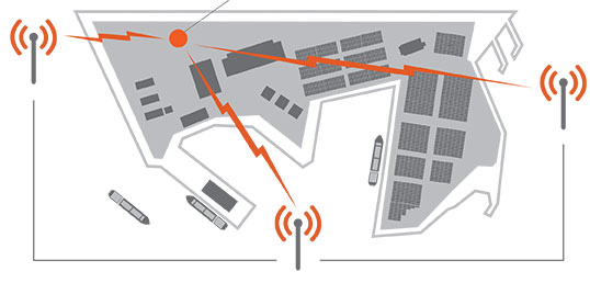
Geofencing is the creation of a virtual perimeter for a real-world geographic area. In the case of GeoEvent Processor, the GIS server is detecting and using geofences to issue an alert when a mobile device approaches, enters, and leaves the geofenced area (which can be based on any map feature). GeoTrigger technology will let developers build geofences into their apps that can be triggered based on time of day, speed, or position. This technology will be available as part of developers’ ArcGIS Online subscriptions in the second quarter of 2013.
GeoEvent Processor for Server makes it possible to use GIS features as geofences and create geofences on the fly Source: Esri
Operations Dashboard for ArcGIS provides a common operating picture for monitoring events. Operations Dashboard integrates maps and a variety of data sources to create comprehensive operational views that can include charts, lists, gauges, and indicators which update automatically as underlying data changes.
Collector for ArcGIS is designed with field crews in mind, and is used to capture and update both tabular and spatial information via smartphones using the built-in GPS capabilities of the device, or by tapping on the map. Data captured using Collector can be displayed in the Operations Dashboard.
Mapping social media data provides insight into what people are saying and where they are saying it. Social Media Mapping apps let you display in real time what people are saying through location-based social media such as Flickr, Twitter, and YouTube.
Esri is also busy adding new features to ArcGIS Online such as Real-Time Data Services, support for GeoRSS Feeds, and more, and we are working with our imagery partners to enable the delivery of Real-Time Imagery in to ArcGIS Online just seconds after it has been captured by satellites.
New types and sources of geographic content, and new ways of sharing them, provide people with exciting new capabilities to incorporate dynamic, real-time information into decision making. The result, as Esri president Jack Dangermond likes to call it, is a Living Atlas of the World—a new vision for the concept of an atlas. “It’s a kind of global gathering place for integrating and applying knowledge about our planet and sharing it with everyone—and to do it all in real time,” says Dangermond.
The thematic information available within this virtual atlas is dynamic; it’s not stored in one centralized, static database—“It’s live, linked to and feeding in from multiple sources across the web and across the world in real time,” adds Dangermond. “The Living Atlas of the World is not only changing the way we look at the world, it is also changing the way we interact with it.”
About Matt Artz
Matt Artz joined Esri in 1989. In his current role as GIS and Science Manager, he helps communicate the value of GIS as a tool for scientific research and understanding. He writes extensively about geospatial technologies, manages the GIS and Science blog, and is the editor of GIS.com. Prior to joining Esri he worked as an Environmental Scientist at a large science and engineering consulting company, on such diverse projects as highway noise modeling, archaeological impact assessment, and chemical weapons disposal. His educational background includes an M.S. degree in Environmental Policy and Planning and a B.S. degree in Anthropology and Geography.
Colorado State University announced that David Prawel and CSU’s Mechanical Engineering department have begun a new program that assists entrepreneurs and others in the community with 3D printing while training students on this revolutionary new technology.
Prawel, a senior research scientist in the Department of Mechanical Engineering, has opened the Idea-2-Product Laboratory to the community so anyone can use this amazing 3-D printing equipment to create prototypes and products, repair parts, beautiful artwork, or virtually anything they can imagine.
Students on hand to help
CSU reports that the lab is staffed by current and graduated engineering students who can provide design and printing expertise. Prawel charges a small fee to recoup costs of materials and maintenance.
Brent MacKenzie, lab manager, works with one of CSU’s 3D printers at the Idea-2-Product Laboratory Source: Colorado State University
“3D printing is very high-value technology that has been proven to increase innovation and accelerate time-to-market for countless entrepreneurs and companies,” said Prawel, who has 31 years of experience working with 3D software and companies, including six companies he helped create. “We provide the equipment and expertise; our users provide the ideas and innovation. You can’t steer innovation – you just have to provide the tools and put some water on it and let it go.”
“The lab currently has five, soon to be seven, machines that can print up to 18 types of materials and create intricate designs that couldn’t be created any other way,” Prawel added. One or two more machines are available for use in the Morgan Library depending on the demand for the machines in the laboratory.
Innovation knows no bounds
“We’re already at capacity – we are running these machines full-time,” Prawel explained, noting that staff assists users until they’re are certified to use the devices themselves. “Users learn how to make their ideas become real products, and on the way they learn things like computer-assisted design and manufacturing and all kinds of things they’ve never thought of before. This helps satisfy the educational mission of our lab.”
Erica Suchman, a professor in the Department of Microbiology Immunology and Pathology, is working with the lab to develop 3-D printed models of virus-antibody models that can be snapped together to create unique epitope binding sites. This allows students to create different antibodies with specificity to different epitopes or shapes on the surface of 3D-printed viruses.
“These models will be given to the students in the class to manipulate creating different antibodies and exploring where on the virus these antibodies can bind, allowing them to visualize a difficult special concept,” said Suchman, who is in the College of Veterinary Medicine and Biomedical Sciences.
I2P software and equipment are funded by contributions from Autodesk, Lulzbot, Advanced Manufacturing Enterprises, the Mechanical Engineering department and by CSU’s students through the university’s Student Fee Review Board. I2P would also like to acknowledge the vision and assistance of the Morgan Library for space, resources and technical support.
MAPPS (www.mapps.org), the national association of private sector geospatial firms, will conduct a “Non-Cash Benefits and Salary Survey” to provide a comprehensive overview of the major salary data and benefit programs for pay levels from entry level technical positions through middle management.
According to the announcement, the survey is the only one conducted by a professional organization collecting data exclusively among private sector U.S. geospatial service firms. The study has been conducted every three years since 2000. Data presented in the salary survey portion of the report is a useful management tool. By comparing a firm’s salary structure to the regional labor market, a firm principal can determine if his or her organization is competitive in salary and benefits for employees, and benchmark possible under – or over-payment in specific employee categories. This information can also help establish the relationship of positions, or internal equity, within an organization.
This nation wide survey gathers data about employee benefits such as paid time off; health, vision and dental coverage; life insurance; short and long term disability plans; bonus programs; savings plans and much more. The results are reported on a consolidated basis, as well as, by size of firm and geographic region. The results give employers the opportunity to compare their benefit package with those of firms of comparable size and geographic location. MAPPS reports that the survey includes a comparative study of changes in wages and benefits from 2010 when the study was last conducted by MAPPS.
The MAPPS announcement says that in addition, firms are able to use the salary survey when submitting salary information for procurement negotiations. The report will be provided free of charge to participating member firms. MAPPS will make the results available to non-member firms for at a premium price.
The web-based survey, to begin on April 15, will be conducted by Compdata Surveys, an independent third party professional data collection company. Individual firm responses and data will be treated with complete confidence. No MAPPS staff or member will see any firm’s information. Any private sector firm in the United States with a desire to receive the results for free can join MAPPS and participate in the survey. A presentation on the survey results will be offered at the MAPPS Summer Conference, July 22 – 26, 2013 at the Samoset Resort in Rockport, Maine. The survey report will be available for sale to non-members, at a premium price, at that time.
Topcon Positioning Systems has released the MR-1 Heading System, an OEM GNSS solution for high-performance positioning and heading.
Using the MR-1 receiver and Topcon’s MG-A8 antenna, the system provides “centimeter-accurate RTK positioning and better than 1/10 of a degree heading accuracy in challenging environments,” said Doug Langen, TPS GNSS product manager. “The rugged MR-1 receiver is water and dustproof and operates at a robust operational temperature range of -40°C to 75°C.”
When combined with Topcon’s Quartz Lock Loop technology, the MR-1 offers continuous operation during “extreme vibration and shock, typical of intense dynamic environments,” he said.
The MG-A8 antenna of the MR-1 Heading System is designed for moving platforms and provides multipath rejection. It also offers increased resistance to near-band interference from satellite communications systems commonly found in marine applications.
The U.S. Military relies on GPS to aid air, land and sea navigation. Like the GPS units in many automobiles today, a simple receiver and some processing power is all that is needed for accurate navigation. But, what if the GPS satellites suddenly became unavailable due to malfunction, enemy action or simple interference, such as driving into a tunnel? Unavailability of GPS would be inconvenient for drivers on the road, but could be disastrous for military missions. DARPA is working to protect against such a scenario, and an emerging solution is much smaller than the navigation instruments in today’s defense systems.
DARPA researchers at the University of Michigan report that they have made significant progress with a timing and inertial measurement unit (TIMU) that contains everything needed to aid navigation when GPS is temporarily unavailable. The single-chip TIMU prototype contains a six-axis IMU (three gyroscopes and three accelerometers) and integrates a highly-accurate master clock into a single miniature system, smaller than the size of a penny. This chip integrates devices (clocks, gyroscopes and accelerometers), materials and designs from DARPA’s Micro-Technology for Positioning, Navigation and Timing (Micro-PNT) program.
Three pieces of information are needed to navigate between known points A and B with precision: orientation, acceleration and time. This new chip integrates tiny devices that can measure all three simultaneously. The design is accomplished through new fabrication processes in high-quality materials for multi-layered, packaged inertial sensors and a timing unit, in a tiny 10-millimeter-square package. Each of the six microfabricated layers of the TIMU is only 50 microns thick, approximately the thickness of a human hair. Each layer has a different function, akin to floors in a building.
“Both the structural layer of the sensors and the integrated package are made of silica,” said Andrei Shkel, DARPA program manager. “The hardness and the high-performance material properties of silica make it the material of choice for integrating all of these devices into a miniature package. The resulting TIMU is small enough and should be robust enough for applications (when GPS is unavailable or limited for a short period of time) such as personnel tracking, handheld navigation, small diameter munitions and small airborne platforms.”
The goal of the Micro-Technology for Positioning, Navigation and Timing (Micro-PNT) program is to develop technology for self-contained, chip-scale inertial navigation and precision guidance. Other recent breakthroughs from Micro-PNT include new microfabrication methods and materials for inertial sensors.
Lockheed Martin has successfully completed a Delta Preliminary Design Review (dPDR) for the next Global Positioning System (GPS) III satellite vehicles planned under the U.S. Air Force’s GPS III program.
The GPS III program will replace aging GPS satellites, while improving capability to meet the evolving demands of military, commercial and civilian users. GPS III satellites will deliver three times better accuracy and up to eight times improved anti-jamming signal power while enhancing the spacecraft’s design life and adding a new civil signal designed to be interoperable with international GNSS.
The Air Force plans to purchase up to 32 GPS III satellites. Lockheed Martin is under contract for production of the first four GPS III satellites, and has received advanced procurement funding for long-lead components for the fifth, sixth, seventh and eighth satellites. The successful dPDR addresses design modifications, agreed on by the Air Force and the Lockheed Martin-lead industry team, which will provide new capabilities for GPS III Space Vehicle 9 (SV09) and beyond, including the addition of a search and rescue satellite payload and a Laser Retroreflector Array (LRA). An innovative new waveform generator permits the addition of new navigation signals after launch to upgrade the constellation without the need to launch new satellites.
“We have worked very closely with the Air Force and GPS community to make GPS III the most affordable and lowest risk solution for bringing new capabilities to the GPS constellation,” said John Frye, Lockheed Martin’s GPS III capability and affordability insertion manager. “The design modifications from this dPDR address ways to further reduce Air Force launch costs by $50 million per satellite through dual launch of two GPS III space vehicles on a single booster. This successful dPDR milestone sets the stage to proceed with SV09 design maturation.”
From the beginning of the program, the Lockheed Martin team has remained focused on affordability for GPS III, the company said, while working to ensure the enhanced satellite system can evolve to continue to meet the world’s global navigation and timing needs for the next 30 years. To help reduce risks and cut costs, the GPS III team developed a GPS Non-Flight Satellite Testbed (GNST), which serves as the program’s ground pathfinder and vehicle demonstrator for the first complete satellite. The entire GPS III development and production sequence uses the GNST to provide space vehicle design level validation; early verification of ground support and test equipment; and early confirmation and rehearsal of transportation operations.
Lockheed Martin team has met recent milestones and appears to be on track to deliver the first GPS III satellite, for launch availability in 2014.
In February, the Lockheed Martin team successfully turned on power to the system module of the program’s first spacecraft, designated GPS III Space Vehicle 1 (SV01), demonstrating mechanical integration, validating the satellite’s interfaces, and leading the way for electrical and integrated hardware-software testing. The satellite will complete its Assembly, Integration and Test (AI&T) in Lockheed Martin’s new GPS Processing Facility (GPF) designed for efficient and affordable satellite production.
The GPS III team is led by the Global Positioning Systems Directorate at the U.S. Air Force Space and Missile Systems Center. Lockheed Martin is the GPS III prime contractor with teammates ITT Exelis, General Dynamics, Infinity Systems Engineering, Honeywell, ATK and other subcontractors. Air Force Space Command’s 2nd Space Operations Squadron (2SOPS), based at Schriever Air Force Base, Colorado, manages and operates the GPS constellation for both civil and military users.
The radio spectrum is about to get even busier, as Europe’s Galileo satnav system starts services, at the same time the European Space Agency (ESA) tests novel satellite-based telecommunication services. Supporting these developments from the ground, ESA’s new custom-built Telecommunications and Navigation Testbed Vehicle will measure the resulting signals from all over Europe.
Adapted from a Mercedes Benz Sprinter van, this unique measurement vehicle has been delivered to ESTEC by Austria’s Joanneum Research institute. “This is a dual-purpose vehicle, suitable for both telecommunications and navigation system testing,” explained Simon Johns of ESA’s Radionavigation Systems and Techniques Section.
“For navigation, we have the Galileo constellation coming on stream, as well as the stepping up of ESA’s GNSS Evolution programme — designing what comes next after Galileo’s first generation.”
The four wheel-drive vehicle can host a three-person team, and is crammed with dedicated navigation and telecommunication monitoring equipment.
Testbed vehicle screen.
“One of the main goals driving the design was to have an ‘easy to adapt’ test platform suitable to set up test campaigns for different mobile satellite systems and standards that would require different types of antennas and specific receiver/transmit equipment,” explained Olivier Smeyers of ESA’s Communication-TT&C Systems and Techniques Section.
“On the telecommunications side, there is a continuous effort to enhance current and create new mobile satellite-based broadcast and interactive services via the evolution of current systems or developing new standards,” Smeyers said. “Testing in the field is an essential element for validating and eventually establishing evolved or new standards. The vehicle has built-in multimedia equipment, including storage and control computers, multimedia gateway, passenger LCD screens, cameras and microphones, to serve this purpose.”
The vehicle features include two removable roof plates to mount specialized antennas (one currently hosts the antenna of a Broadband Global Area Network satellite terminal for Internet connectivity and multimedia and data streaming), an 8-meter-high telescopic mast capable of carrying 25 kilograms, a rubidium atomic clock synchronized to GPS time with nanosecond accuracy, a high-end spectrum analyzer and oscilloscope for signal measurements, and mobile temperature sensors to monitor the rack equipment.
A fish-eye video camera incorporating onscreen GPS timing and positioning performs continuous recording of its surroundings — to throw light on high buildings, trees, or other factors that might affect results.
Internal and external generators yield up to 5 kilowatts to keep everything running — sufficient power to supply two typical European households.
“The challenge was to fit in all the equipment and provide the necessary power and air conditioning, while still weighing less than 3.5 tonnes,” said Thomas Prechtl of Joanneum Research. “Exceeding this weight would have meant drivers would have needed a special license, and potentially limited its operations in some European nations.”
Neither rain, sleet, snow, hail, wind, nor dark of night will deter…
Loosely Translated, Herodotus, Histories (8.98)
…attendees at the 29th National Space Symposium from their appointed rounds.
Seriously, folks, with apologies to postal workers everywhere, here in the Rocky Mountains it was 72 degrees on the eighth of April, the first day of the largest space symposium in the world. This morning, the ninth, the startled thermometer hovered around eleven degrees with snow, high winds and attendees searching for any outer wear they could find. And except for NASA (National Aeronautics and Space Administration) personnel, everyone braved the weather and soldiered on.
NASA, of course, one of the few government agencies with space in its name, decided they did not need to attend the National Space Symposium this year. But that is NASA’s loss and a story for another time, because more than 9,000 other dedicated space professionals did attend, and more than 170 companies provided major exhibits that filled to capacity the largest pillar-less exhibition hall west of the Mississippi. Just writing this makes my feet hurt. And the best part is this all takes place at the five-star Broadmoor Resort in the foothills of the Rocky Mountains, hence Mother Nature’s raucous spring weather shenanigans.
This is truly a watershed event for the global space community, and it improves every year. I have had the honor of attending 25 of the 29 National Space Symposiums, and as usual there are always a few major topics of interest that everyone wants to discuss. This year I can literally not walk ten feet without someone stopping me to discuss:
The error-plagued GAO (Government Accountability Office) OCX (Next Generation GPS Operational Control System) report and subsequent regrettable sensationalized news reports
The actual status of the OCX program
Lockheed Martin’s GPS III program
NavSat – Nee Parkinson’s NibbleSat – real or imagined
Software-defined GPS receivers and GPS user equipment in general
When it comes to opinions, informed or otherwise, concerning each of these topics, the resulting litany reminds me of the old saw about asking three psychologists to comment on a patient’s diagnosis, and you will invariably wind up with four opinions. But have no fear: I spoke directly with the prime companies developing each of these programs, and the following is straight from the horse’s mouth, or some other part of their anatomy as the case may be. You be the judge.
GAO and OCX
The Government Accountability Office, which historically is anything but, released a report on March 28titled “Defense Acquisitions: Assessments of Selected Weapon Programs,” in which it seems to claim that the original $886 million GPS OCX program awarded to Raytheon Information Systems in Aurora, Colorado, in February 2010, has grown by 43 percent and ballooned to $3.695 billion. In fact, the report does not actually say that exactly, but you have to dig deep to determine that. Most readers won’t take the time to do that and will assume that the OCX program is grossly over budget. It is not. In fact, to reach that extraordinary number, OCX cost overruns would need to have grown by 43 percent for each year since it was awarded, and that is ludicrous. According to Raytheon VP and OCX Program Manager Ray Kolibaba, the $3.695 billion number probably comes from including “…programmatic costs beyond OCX development costs and pessimistic projections from the government” that in my experience no acquisition agency, nor Congress for that matter, would ever include when determining true program cost adherence parameters. Such ancillary costs would certainly never be included in a Nunn-McCurdy-Sarbanes-Oxley-Graham-Rudman-Harry Potter fiscal responsibility evaluation.
Speaking from personal experience, in 1990 I was appointed the very first Legislative Liaison Director for Headquarters Air Force Space Command. I had a small office and staff and spent most of my time on Capitol Hill meeting with congressmen and senators, where I advocated the latest space programs, and/or sat in on congressional hearings and then advised senior U.S. Air Force space officials on what budget and policy decisions they could expect from Congress. And I can tell you now, using the methods the GAO concocted to compile this report, I could cause any space program to come under close and unwarranted scrutiny. However, using time-tested congressional oversight rules of engagement (ROE), OCX has not come close to triggering any of the automated congressional watchdog cost overrun tripwires. The truth of the matter is OCX has grown in scope and schedule due in part to government change requests, mainly in the cyber and information assurance areas, along with affordability mandates due to schedule slips and sequestration. According to Stephen Moran, Raytheon mission solutions director, the true cost of OCX today is approximately $967 million, which means the total program cost to date has grown by approximately 10 percent, a far cry from the fictitious annualized 43 percent increase claimed by the GAO. While the GAO goes to great lengths to justify its inflated numbers, it is comparing or rather sensationalizing apples and oranges.
Some may say, so what? Who outside of Washington D.C. reads or believes GAO reports? Unfortunately, Congress, the congressional staff and congressional budgeters read these reports, since the GAO is officially the investigative arm of Congress. In fact the GAO is an independent, nonpartisan agency that works for Congress. Often called the “congressional watchdog,” GAO investigates how the federal government spends taxpayer dollars. And many times they do a great job. But in this case they are wide of the mark. It would be a shame if Congress cancelled OCX because of a flawed or, at a minimum, a poorly explained report.
Ray Kolibaba and Stephen Moran assured me during our talks at the 29th NSS that OCX was alive and well and on track to meet a re-baselined time and costs schedule. OCX Block One RTO should occur as planned in the first quarter of 2017 and will include the ability to launch and control GPS IIF and GPS III satellites and payloads, but not GPS IIA satellites and payloads. That mission, along with the responsibility for maintaining residual satellites, still falls to the LADO (Launch Anomaly and Disposal Operations) contractor Braxton Technologies, which is an OCX subcontractor to Raytheon.
The bottom line is the OCX schedule has slipped and the budget has grown, but within historically acceptable parameters; certainly, it is not even close to triggering congressional oversight. However, having said that, in this budget sequestration environment, the overall GPS budget has taken some significant hits so that even the slightest cost overrun is of concern. Still, let’s hope that Congress makes funding decisions using actual historically acceptable numbers and not overblown rhetoric.
LMCO and GPS III
Keoki Jackson
Let me say right up front that I really like Keoki Jackson and what he has accomplished on the GPS III program at Lockheed Martin. Keoki is the vice president of Navigation Systems, and as such heads the GPS III program. Keoki has an honest and open demeanor and just oozes integrity. He runs a very open program and, indeed, has extended an open invitation to me, wearing multiple hats, to visit the LMCO GPS III facility in Waterton, Colorado, to discuss GPS III anytime. Believe me, I have and will continue to take him up on his offer. To someone in my line of work, that confidence speaks volumes. Keoki obviously has supreme faith in his people, and is assured the GPS III program is on the path to success. I spoke with Keoki on Monday, April 8, as I toured the GPS III facility with him. He was like a father with pictures of his children. Happy, smiling, engaging — he could not wait to show off their latest accomplishments.
My bottom line is this is a rare attitude among senior execs and PMs on major space programs. And that may be because so many of them are under congressional scrutiny. Not the case for GPS III, however. The back-to-basics GPS III program is on schedule and budget, and is set to deliver GPS III SV-01in May 2014, exactly six years after program award. The USAF has said it may not launch the first GPS III until April 2015, but that is a separate ground support and commanding issue. It has nothing to do with the schedule and availability of the GPS III satellites.
Historically, LMCO-built satellites are some of the best in the world. According to LMCO statistics, and verified by yours truly, LMCO GPS satellite vehicles have accumulated more than 175 operational years on orbit with a reliability record better than 99.9 percent. Keoki also proudly pointed out that the Lockheed Martin heritage dates back to the production of the Oscar and Nova Transit satellites — programs that paved the way for the current GPS gold standard on orbit today.
Now, don’t let the back-to-basics approach fool you. That just means sound, solid, proven engineering and management practices are employed, but the technology is anything but basic. The kingpin of the LMCO GPS III approach is an artifact known as the GNST, or pathfinder spacecraft. The GPS III Non Flight Satellite Testbed (GNST) gives everyone confidence that Lockheed is on the right track. The pathfinder goes through all the rigorous steps a flight article goes through, only it completes them first and allows LMCO personnel to find all those schedule-busting, expensive glitches that show up in any program. As Keoki said, “Our endeavor is to find any anomalies now before the satellites and payloads are on orbit.” The GNST, along with cutting-edge 3-D motion studies with avatars (an amazing story and teaser for another time), will hopefully allow a smooth transition for SV-01 through SV-09 when the program plans to initiate programmatic and hardware changes to allow for the first-ever GPS dual launch.
This is a far different approach from the Boeing GPS IIF spacecraft and payloads, which experienced major anomalies on orbit for the first two SVs. Changes were made to subsequent ground space vehicles before launch, but the first two SVs on orbit are stuck with those anomalies. The LMCO approach hopes to eliminate or at least minimize that risk. If the full LMCO GPS III program comes to fruition, there could eventually be as many as 32 GPS III satellites in various configurations on orbit. Which means Keoki will probably be referring to GPS IIIs not as children but grandchildren, and he will need a much bigger scrapbook. Bottom line, GPS III is alive and well, on schedule and budget.
NavSat or NibbleSat
For those of you who have not heard about the NavSat or NibbleSat, it is a small GPS satellite endeavor by AFSPC, SMC, and AFRL to determine the feasibility of building a GPS-only small satellite, one without NDS, SAR, or any other auxiliary payloads. However, this is not solely a Weight Watchers program — it is about far more than a slimmed-down GPS. It addresses technological aspects of the GPS program as well as SWAP (size, weight, and power) issues that have plagued the GPS program since its inception.
Since 1978 when the very first GPS satellite was launched, the program has grown in complexity and size with ancillary payloads, more signals, more power, and more flexibility, which all add up to a heavier, more complex satellite — and in space, where weight and complexity equal greater costs. GPS III has finally reached the point that it will cost nearly $450 million to place a single GPS SV and payload in orbit.
As I said earlier, the GPS III payload may last 30 years, which equates to a sizeable return on your investment (ROE) for space assets, but in this constrained sequestration budget environment Congress is not looking down the road 30 years; it is barely able to consider the FYDP or the next five years’ development plan budget. So $450 million per GPS III on orbit is a big number. Even with dual launch, according to Lockheed’s Keoki Jackson (see above, “LMCO and GPS III”), from SV-09 forward the savings will only amount to about $70M per launch because it will require a larger launch vehicle. Certainly, $70 million is not a number to disregard, especially if you could build and launch a small GPS-only SV for that same amount. I know it sounds nearly impossible, but that is what the NavSat program hopes to achieve. To date, no less than 20 companies, U.S. and European, have expressed an interest in making NavSat happen. Most companies I spoke with are convinced it is not a technological issue, but a commitment and funding issue on behalf of the U.S. government. So what else is new? In my book, NavSat is a real possibility, and the recent plethora of BAAs (Broad Area Announcements) from SMC (Space and Missile Systems Center), AFRL (Air Force Research Laboratory), and SPAWAR (Space and Naval Warfare Systems Command) attest to that fact. Stay tuned for more.
GPS Payloads, Receivers: Software-Defined and Otherwise
It is a fact of life where GPS is concerned that when you talk about GPS technology, you are talking about ITT Exelis. There is not a single U.S. GPS payload on orbit today that was not built in whole or in part by ITT Exelis. There are few companies in the world today that can claim such a prestigious record for space assets that are arguable the best in the world. The ITT Exelis record of providing proven GPS payloads for 35 years is unequaled in the space arena, and the company continues to innovate and grow. So, it should come as no surprise that Exelis provided LMCO with the GPS payload for the GNST pathfinder mentioned earlier. The bottom line is, when it comes to GPS payloads, nobody does it better than ITT Exelis.
Therefore, I took the opportunity to sit down with Mark Pisani, a vice president and general manager in the geospatial systems business at ITT Exelis, to discuss the recent $2.15 million contract award from AFRL to research navigation payloads to support the current GPS program and the NavSat program specifically. Mark stated that the technologies being investigated could easily translate to the entire GPS program.
Mr. Pisani stated that over the next 18 months, the company will conduct research into potential methods to reduce payload size, weight, and power, and improve GPS signal strength and reception for disadvantaged users, especially warfighters, in either urban canyons or mountainous terrain. ITT Exelis is also working on new methods of tamper-proofing for its GPS reference and monitor receivers, which will deployed around the globe to ensure GPS accuracy for all global users. So it appears that where GPS is concerned, you name it and ITT Exelis is working some aspect of the program.
NSS Wrap-up
Space Foundation Leadership Team.
NSS 29 is still in full swing as I write this. Indeed, my old friend and colleague in uniform, General William (Willie) Shelton, just gave his state-of-the-military-space-community address, and he did it in his usual exemplary manner. Few generals can match his grace and style. But to paraphrase Robert Frost, “…deadlines, time and tides wait for no man,” so I will wrap up with a few personal observations.
As many of you have heard me say, year after year, the National Space Symposium is like no other space event in the world. It gets bigger and better every year, and this year events extended all the way to LMCO in Denver and to Broadmoor properties that have never been used for this event previously. The NSS agenda and speakers are top notch and international in nature. Just a sampling are George Nield, associate administrator for commercial space transportation at the Federal Aviation Administration (FAA), Jean-Jacques Dordain, director general of the European Space Agency (ESA), and Yasushi Horikawa, chairman of the United Nations Committee on the Peaceful Uses of Outer Space. Officials from commercial space leaders such as LMCO, SpaceX, Boeing, XCOR Aerospace, Sierra Nevada Space Systems, and others will also speak, while actress Sigourney Weaver, star of the Alien films among others, is the featured speaker at the Space Technology Hall of Fame gala tomorrow night. So there is literally something for everyone.
Sigourney Weaver
I have known Elliot Holokauahi (yes, it is a mouthful) Pulham (CEO), Chief Chuck Zimkas (USAF, Ret) who serves as president of the Space Foundation, and Holly Roberts, the CFO, for many, many years, and they are always striving to make the National Space Symposium better every year; in my book, they have succeeded beyond anyone’s wildest dreams. Their zeal is combined with the dedicated support of Steve Bartolin, CEO and president of the Broadmoor. I first met Steve more than 25 years ago when he ran the famed Greenbriar Resort in White Sulphir Springs, West Virginia, the playground of congressmen and senators. Steve has always had a penchant for living in places that ended in Springs, as well as for perfect service, while going to great lengths to make sure his employees are happy and enjoy their work. It shows at the Broadmoor, which is a Triple AAA Five Diamond Resort, and has been for more than 20 years. Together, Steve’s commitment to perfection and the vision of the Space Foundation make the National Space Symposium not only the world’s largest but by far the best space symposium in the world today.
Braxton Technologies Sets the Example
Personally, I enjoy the exhibit hall and tend to spend most of my time there. The event along with the Cyber presentations lasts for four full days, but you cannot see and do everything in that time, which leads me a personal observation. Many of the vendors and exhibitors in the past several years have begun to offer refreshments in their booth space, to help draw in the huge crowds always roaming the exhibition floor. Some offer ice cream, coffee, even beer and pretzels, but personally I like what Braxton Technologies has developed. Remember, this is a Space Symposium, so Braxton decided to mount small-scale full working models of various satellites above their booth space and allow attendees to actually send wireless commands to control the satellites. You can sit at one of their control stations, see a real spacecraft commanding (TT&C) screen, send commands to the scale-model satellites, and watch the satellites react in real time.
Now, Fred (I call him the model builder and engineer extraordinaire) is the one who built the majority of the models, and they are an excellent example of fine craftsmanship. Indeed, the first night there were some issues with one of the older models, and Fred stayed in the booth working the problem from closing time on Monday evening until 0700 on Tuesday morning. And his hard work paid off, because there is always a crowd around the Braxton booth waiting to control or just watch the satellites respond. The Braxton folks are very good at and very proud of what they do, and it shows. They automated GPS scheduling, on their own nickel last year, and this year offer a glimpse at the future of GPS mission planning. Plus, they have an application for unimproved aircraft landing sites around the world that is simply amazing.
But, in the end it is watching the children, the future space operators and astronauts, who gather in huge crowds around the Braxton booth, waiting with thinly veiled anticipation to send a command to a satellite. It has been a long time since I was a child, but you should have seen the smile on my face when Fred allowed me to send a command and I could see the satellite model respond. Both Frank Backes, Braxton CEO, and Kenny O’Neil, Braxton president, and most of the Braxton employees are former space operators, and they have not forgotten the thrill of actually commanding satellites. Now they have made that thrill available for our future space operators. I think they hit it out of the park.
There’s still time. Drop by the Braxton booth, speak with Fred, and send a command to a satellite. Oh, and you are allowed to smile!
Until next time, happy navigating, and go fly a satellite!
A major exhibition opening April 12, “Time and Navigation: the untold story of getting from here to there,” explores how revolutions in timekeeping over three centuries have influenced how people find their way. This project is a unique collaboration between two of the Smithsonian’s largest and most popular museums: the National Air and Space Museum and the National Museum of American History.
“Time and Navigation is an ambitious exhibit because it traces the development of very complicated technologies and makes us think about a subject we now take for granted,” said Gen. J.R. “Jack” Dailey, director of the museum. “Today, the technology needed to accurately navigate is integrated into mobile computers and phones: hundreds of years of technological heritage tell your handheld device where you are in a seamless manner. This opens up new possibilities and challenging questions for the next generation of scientists and explorers who visit this exhibit to start thinking about.”
The gallery is organized into five sections and spans three centuries of efforts to travel on Earth and through the solar system. In each section the visitor will learn about pioneer navigators facing myriad issues, but one challenge always stands out: the need to know accurate time.
Sections
This timekeeper was the first American-made marine timekeeper taken to sea. William Cranch Bond, a 23-year-old Boston clockmaker, crafted it during the War of 1812.
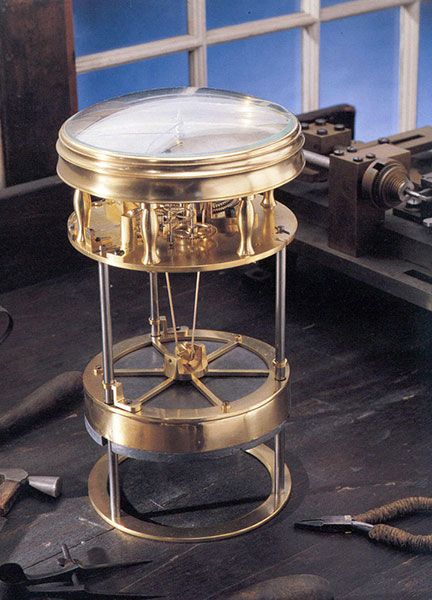
Navigating at Sea is an immersive environment that suggests a walk through a 19th-century sailing vessel. Visitors will learn how centuries ago navigators at sea relied on chronometers and measurements of celestial objects to determine location. This section includes a mariner’s astrolabe, dating from 1602; a Ramsden sextant and dividing engine; several chronometers; a model of Galileo’s pendulum clock; and the earliest sea-going marine chronometer made in the United States, produced by Bostonian William Cranch Bond during the War of 1812. It also features an interactive display that allows visitors to use a sextant to navigate with the stars.
Navigating in the Air relates how air navigators struggled with greater speeds, worse weather and more cramped conditions than their sea-going predecessors. It tells the story of the innovations that overcame these challenges, as represented the gallery’s largest artifact, the Lockheed Vega “Winnie Mae,” flown by Wiley Post and Harold Gatty, shattering the around-the-world record in 1931. Visitors will learn that Charles Lindbergh required navigational tutoring after he flew to Paris and how he paved the way for a new system of navigation in the process. A personal account by a WWII navigator highlights wartime innovations. This section ends with an explanation of how clocks with tiny quartz crystals opened an entirely new era of navigation in the form of LORAN (LOng RAnge Navigation).
Wiley Post’s Winnie Mae circled the globe two times, shattering previous records. The first time was in 1931 with Weems associate Harold Gatty as lead navigator. The second was a solo flight in 1933 assisted by “Mechanical Mike,” one of the world’s first practical autopilots.
Navigating in Space traces how teams of talented engineers invented the new science of space navigation using star sightings, precise timing and radio communications. This section includes an Apollo sextant, a space shuttle star tracker, timing equipment used at a ground tracking station and a flight spare (duplicate spacecraft) of Mariner 10, the first spacecraft to reach Mercury.
Inventing Satellite Navigation describes how traveling in space inspired plans to navigate from space. Innovators found that time from precise clocks on satellites, transmitted by radio signals, could be used to determine location. The U.S. military combined several breakthroughs to create the Global Positioning System. Some of the artifacts in this section are the NIST-7 atomic clock that served as the U.S. time standard in the 1990s, the navigation system from the nuclear submarine U.S.S.Alabama, a satellite from the Transit system used for global navigation before GPS and a test satellite global navigation built at the Naval Research Laboratory.
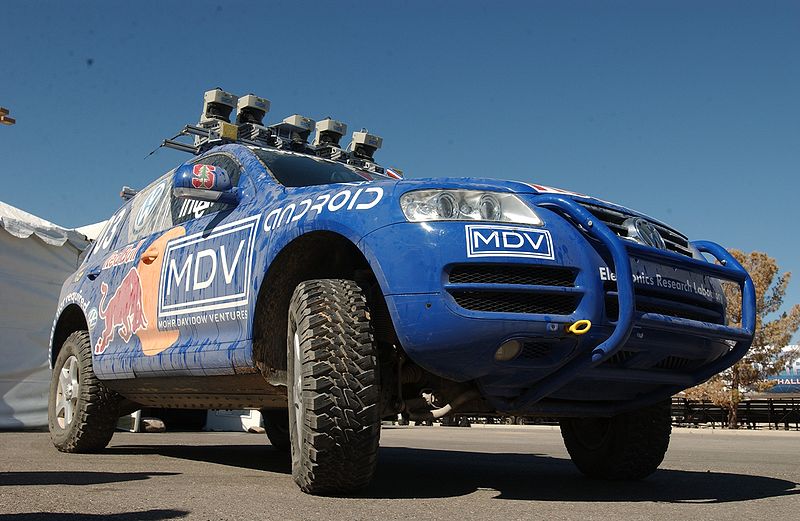
An official DARPA photograph of Stanley at the 2005 DARPA Grand Challenge. Stanley, created by the Stanford University Racing Team, won the race.
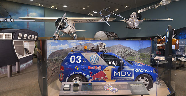
Navigation for Everyone tells the stories of real people — a fireman, a farmer and a student — who use modern navigation technology in their everyday lives. It also addresses what might come next: the story is not over yet and many new technologies are being developed. This section includes a disassembled mobile phone with a diagram showing all its parts and depicts how hundreds of years of navigation technology are now in the palm of a user’s hand. It also features “Stanley,” the robot car that won the 2005 Grand Challenge, a robot race sponsored by the Defense Advanced Research Projects Agency.
The exhibition is made possible through the support of Northrop Grumman Corporation; Exelis Inc.; Honeywell; National Geospatial-Intelligence Agency; U.S. Department of Transportation; Magellan GPS; National Coordination Office for Space-Based Positioning, Navigation and Timing; Rockwell Collins; and the Institute of Navigation.
The National Air and Space Museum building on the National Mall in Washington, D.C., is located at Sixth Street and Independence Avenue S.W. The museum’s Steven F. Udvar-Hazy Center is located in Chantilly, Va., near Washington Dulles International Airport. The National Museum of American History collects, preserves and displays American heritage in the areas of social, political, cultural, scientific and military history.
GreenRoad has announced the integration and availability of GreenRoad Advanced Tracking, powered by GPS Insight fleet tracking service. GreenRoad Advanced Tracking provides fleet operators with a new level of insight into fleet performance, resulting in improved fuel economy, better asset utilization, and enhanced productivity, GreenRoad said.
With the availability of GreenRoad Advanced Tracking, GreenRoad adds powerful fleet management capabilities to its best-in-class driver performance and safety solution, which combines real-time, in-vehicle safety feedback with a management portal that provides insight and guidance.
“GreenRoad Advanced Tracking builds on the GreenRoad Connected Fleet vision by giving managers deeper, broader insight into how they’re using their fleet assets, in addition to how their drivers are performing,” said Karen White, senior vice president of customer solutions for GreenRoad.
Additional highlights of GreenRoad Advanced Tracking include:
Interactive displays of entire fleet, any vehicle group or single vehicle. Color-coding for easy status identification, 2D and 3D mapping, vehicle history trails, automatic alerts when management attention needed.
Increased fleet activity insight with landmark and geofence support. Automatic alerts when a vehicle enters or leaves a landmark or group of landmarks.
Enhanced reporting to optimize fleet resources. Multiple, detailed activity reports including Drive Time Summary, Fleet Utilization and Odd-Hours Violations. Vehicle MPG reports available with fuel card transaction data integration.
A customizable dashboard runs specific reports and provides managerial insights with a minimum of mouse clicks.
TomTom has launched a new resource to showcase the range of business applications available for integration with its fleet management technology.
The TomTom Business Solutions App Center is a dedicated web resource, detailing a range of partner applications ready for integration with TomTom’s WEBFLEET platform. These include office solutions, such as CRM, ERP, scheduling and planning software.
This move is at the heart of TomTom Business Solutions’ strategy to create added value for connected vehicle and fleet management solutions and expand its network of development partners.
“The new App Center will enable companies to identify those solutions that can be swiftly deployed and integrated with their TomTom system,” said Thomas Schmidt, TomTom Business Solutions’ managing director.
“By bringing fleet management data together with information from a host of other software systems, companies can benefit from greater efficiencies across all areas of their business — from workflow management to customer service. With our seamless integration options customers do not have to change the way they work, they simply improve it ”
The App Center will also host in-vehicle and mobile applications. Recently, TomTom opened the Bluetooth channel on its in-vehicle LINK tracking device, enabling connectivity with a host of hardware devices for use in and around the vehicle.
The App Center launch is designed to spark the development of more integrated business applications, further enhancing the potential of TomTom’s fleet management platform. Developer partners can work with TomTom’s API WEBLFEET.connect and LINK.connect to create new solutions.
ITT Exelis is offering the Signal Sentry 1000, a proprietary product that detects, geolocates, and characterizes sources of intentional and unintentional interference to the U.S. GPS signals, and provides actionable intelligence to the user.
The system leverages GNSS signal domain knowledge, and is based upon patented technology developed through the company’s history of designing and fielding electronic intelligence systems, ITT Exelis said.
Leveraging Exelis GNSS signal domain knowledge, the system is implemented using commercially available GPS receiver and computer server/data technology. Actionable intelligence is available in the form of pin mapping of interference sources in addition to longitude/latitude/altitude data, all available through a web-enabled graphical user interface.
Signal Sentry 1000 can assist efforts to ensure GPS spectrum integrity and aid in law enforcement operations that require GPS availability. Benefits for users include:
Instantaneous identification and geolocation of jamming sources, improving situational awareness.