We have turned back the LightSquared effort to establish a threatening beachhead adjacent to GPS spectrum bands. Having expended many millions, we can now return to our business, secure in having demonstrated both our rights and our rightness.
No. We cannot afford to do that.
Radio spectrum is today’s natural resource, vital to current ventures and even more essential to future business and national growth of all kinds. It is far too valuable to be taken for granted, and far too vulnerable to be left protected simply by the Plan A recently executed.
We will see attempt upon attempt upon attempt to use closely neighboring frequencies in disturbing ways — and, I daresay, to dislodge GNSS from the bands it now holds, by redistributing, re-allocating, and/or redefining spectra.
Digging in deeper will not answer. It is questionable even now whether the numbers of GPS installed user base or the dollars they represent were sufficient to turn back the LightSquared initiative. It may have been, purely and simply, the Pentagon and the FAA.
At any rate, the millions of installed GPS users and billions of dollars in industry and infrastructure may soon be dwarfed by billions of potential users and gazillions in economic benefit that broadband or any other spectrum-driven enterprise may muster. The future is wide open, as they say. It moves fast.
Two courses of action show promise; there may be more.
Participate actively, pro-actively, even aggressively — and certainly with no time to waste — in the effort to define receiver standards. The NTIA and PNT EXCOM will devise “standards for the development and procurement of GPS receivers to support their various mission requirements.” NTIA recognized “the importance that receiver standards could play as part of a forward-looking model for spectrum management even beyond the immediate issue of GPS.”
Get on board, bring productive ideas, work them through the process as efficiently and cooperatively as possible. Then design new products accordingly. Regulatory agencies, national and international, will have little patience with broadened use of other bands, no matter how long high-precision receivers have been doing it. We have been put on notice.
Aid, encourage, design products for interoperable GNSS, not to mention modernized GPS, particularly L5. Seek touchpoints with Galileo, GLONASS, and Compass developers, operators, and manufacturers. The broader, more wide-laned the base, the more frequencies that users and equipment can draw on, the more stable will be their operations, and the less vulnerable to encroachment, interference, or downright exclusion.
Perhaps you have thought of other ways to ensure GNSS viability in a future of increasing demands for spectrum. I would love to hear them, and share them with our readers.
Using a large network of GPS stations, a team of researchers has found that the Rio Valley Rift in the Southwest United States — previously suspected to be dead — is slowly expanding, at a rate of about 0.1 millimeter per year.
The Rio Grande Rift extends from Colorado’s central Rocky Mountains to Mexico.
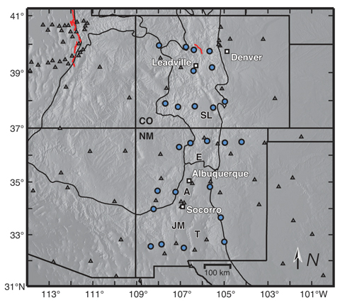
The study was conducted by scientists at the Cooperative Institute for Research in the Environmental Sciences (CIRES) at the University of Colorado at Boulder, in collaboration with the University of New Mexico, New Mexico Tech, Utah State University, and UNAVCO.
“We don’t expect to see a lot of earthquakes, or big ones, but we will have some earthquakes,” said study author Anne Sheehan, CIRES Fellow and associate director of CIRES Solid Earth Sciences Division. “We use continuous measurements of GPS sites from across the Rio Grande Rift, Great Plains, and Colorado Plateau to estimate present-day surface velocities and strain rates,” Sheehan said.
Using GPS instruments at 25 sites in Colorado and New Mexico, the team tracked the rift’s miniscule movements from 2006 to 2011. The team found an average strain rate of 1.2 nanostrain each year across the experimental area. A nanostrain is a change in length of one part per billion, thus 1.2 nanostrain per year is equivalent to 1.2 millimeter per year extension over a 1000-kilometer length.“If you picked two points in New Mexico, and one of them lies 100 kilometers to the west of the other, then they would be moving apart at a rate of 0.1 millimeter per year,” explained researcher Henry Berglund.
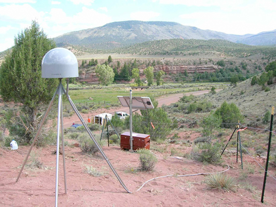
Researchers used data from 25 continuous GPS stations installed as part of the EarthScope Rio Grande Rift GPS experiment, supplemented by data from other GPS monuments in the southwestern U.S., resulting in a data set of daily position estimates of 284 GPS monuments for the years 2006 through 2010.
“It is lower than we thought but it does exist,” Sheehan said. “Some people thought it was zero but we are seeing things are extending slowly.”
The slow rates of motion made previous attempts to determine tectonic activity difficult. Previously, geologists had estimated the rift had spread apart by up to 5 millimeters each year but the errors introduced by the measuring instrumentations were significant. “The GPS has reduced the uncertainty dramatically,” Sheehan said. “This is the most comprehensive and accurate set of geodetic measurements in this area to date.”
The extensional deformation is not concentrated in a narrow zone centered on the Rio Grande Rift. Instead, it is distributed broadly from the western edge of the Colorado Plateau into the western Great Plains — a span of more than 370 miles. “This unexpected pattern of broadly distributed deformation at the surface has important implications for our understanding of how low strain-rate deformation within continental interiors is accommodated,” Sheehan said. “Questions we wanted to answer are: how is the Rio Grande Rift deforming? Is it alive or dead? Is it opening or not?”
Along the rift, spreading motion in the crust has caused magma to rise to the surface, creating long basins susceptible to earthquakes. “The rift is still active,” Sheehan said.
The team plans to continue monitoring the Rio Grande Rift, and may attempt to determine vertical as well as horizontal activity to determine whether the Rocky Mountains are still uplifting.
University of Colorado (Boulder) student Henry Berglund services GPS site RG20 west of Silverton, Colorado.
The study’s findings shed light on how continents deform away from plate boundaries, Sheehan said. At plate boundaries scientists can clearly see what is going on. “Things move past each other and crash into each other. At active plate boundaries, the rates of motion detected by GPS can be centimeters per year. Compare that with the fraction of a millimeter per year that we have measured for the Rio Grande Rift.”
“Present day measurements of deformation within continental interiors have been difficult to capture due to the typically slow rates of deformation within them,” Berglund said. “Now, with the recent advances in space geodesy, we are finding some very surprising results in these previously unresolved areas.”
The National Science Foundation funded the study. EarthScope and UNAVCO provided instruments, equipment, and engineering services. Results of the study were published in the January 2012 issue of Geology magazine.
GPS monuments in the vicinity of the Rio Grande Rift and southern Rocky Mountains. The study included construction of 25 GPS monuments (blue circles) in Colorado and New Mexico in 2006 and 2007. Regional EarthScope Plate Boundary Observatory and Continuously Operating Reference Station monuments are shown by gray triangles.
In my 20-plus years of involvement in the GPS/GNSS industry, nothing has come close to the LightSquared debate for technical and political complexity, nor for potential effects on nearly every high-precision GPS/GNSS user in the United States. The industry’s destiny is somewhat controlled by a federal agency that is not very knowledgeable about how, when, and where GPS is used — although I’m sure they’ve learned a lot in the last 14 months.
While receiver manufacturers have a firm grip on the technical complications of what LightSquared proposed, they have jockeyed for market position, as information released to the public is filtered through their marketing heads. Finally, media coverage is all over the place, from “LightSquared is doomed” to “this will happen.”
On January 13, as we all know, the U.S. deputy secretaries for defense and transportation wrote, on letterhead of the Space-Based Positioning Navigation & Timing National Executive Committee (PNT EXCOM), to the head of the National Telecommunications Information Administration (NTIA), declaring that “there appear to be no practical solutions or mitigations that would permit the LightSquared broadband service, as proposed, to operate in the next few months or years without significantly interfering with GPS.”
On February 14, the NTIA director wrote to the Federal Communications Commission (FCC) chairman in a similar vein with nearly the same language. That same day, the FCC stated its intent to “not lift the prohibition on LightSquared,” and to “vacate the Conditional Waiver Order, and suspend indefinitely LighSquared’s Ancillary Terrestrial Component authority.”
It just so happens that LightSquared cannot accomodate military GPS users nor aviation GPS users. Those of you who use high-precision GPS can thank your lucky stars that the military and aviation folks are standing in your corner. Otherwise, as I warned back in May of last year, high-precision users would have been thrown under the onrushing bus of national broadband.
In testimony to a House of Respresentatives subcommittee meeting on GPS and aviation in early February, the Transportation deputy secretary revealed that the Federal Aviation Administration (FAA) spent more than $2 million of taxpayer dollars with two different independent labs to conclude that LightSquared proposals were not compatible with several GPS-dependent air safety-of-flight systems.
Don’t expect the Department of Defense (DoD) ever to provide similar testimony. The Pentagon played its veto card off-air and out of the public eye.
LightSquared has continued to complain about GPS receivers “looking into our spectrum” as the reason for the interference GPS receivers are suffering. If you missed Richard Keegan’s December 2011 article in GPS World, you should take a look. He succinctly addresses this issue, as I did in my November 2011 Survey Scene column.
As LightSquared has clearly lost the engineering argument, it has taken a very creative approach in an attempt to convince the FCC that this isn’t an engineering problem, but rather all about the FCC rules. LightSquared petitioned the FCC to confirm that “GPS devices are not entitled to protection from interference.”
Crazy statement? If you think so, see if you recall reading this statement on equipment such as GPS receivers. It is on almost every electronic device that relies on radio signals.
“This device complies with Part 15 of the FCC Rules. Operation is subject to the following two conditions:
“(1) This device may not cause harmful interference, and (2) this device must accept any interference received, including interference that may cause undesired operation.”
What if LightSquared can convince the FCC that GPS receivers do, indeed, fall within the confines of Part 15 of the FCC rules and aren’t entitled to interference protection? That’s what the company is trying to do, and that’s why this fight ain’t quite done.
Don’t underestimate the power of the White House pushing the National Broadband Plan, or of commercial interests — of which there are myriad — seeking to turn a buck on the hunger, whether real or only perceived, for limitless broadband. Even the transportation depsec allowed in his testimony as how “in the Obama administration, we believe deeply in what LightSquared is attempting to do, which is to make the Internet more accessible to more people all across the country. This is an urgent national priority.”
Communications for My RTK
Some people in the GPS industry who believe that the LightSquared service will do wonders for RTK operations, somehow replacing the communications methods we currently use (UHF/VHF, 900MHz, GSM/GPRS, CDMA, Wifi/Mifi, etc.). I disagree.
LightSquared was relying on Sprint’s infrastructure (~31,000 towers) for its terrestrial operations, supplementing them with ~3,400 LightSquared towers at some point. I’ve used Sprint’s mobile phone service for about 12 years and I used Sprint’s data card service for several years (not any longer). I pretty much know that Sprint is good for metro areas and poor for rural areas. Like other wireless providers (AT&T, Verizon, T-Mobile, etc.), Sprint is strong in some geographic areas, and weak in others. Since LightSquared is focused on serving people (densely populated areas) rather than geographic areas (e.g., farmlands), their terrestrial service is not going to be even close to being nationwide. LightSquared’s solution for areas not covered by their terrestrial service is to use satellite communications for Internet connectivity.
If you think you would enjoy ubiquitous coverage with satellite communications for your RTK operations, consider OmniSTAR’s service, which is in the same spectrum as what LightSquared proposed. OmniSTAR works great when there’s a clear view of the sky to one of OmniSTAR’s satellites (ironically, operated by LightSquared) such as in the agriculture industry. But I’ve used it a bit and — just like GPS — it doesn’t work in buildings, in vehicles, under trees, or in other obstructed-sky locations.
Can you imagine using a LightSquared mobile phone that doesn’t work in buildings, in cars, or under trees? You wouldn’t. Anyone who’s ever used RTK knows that spotty base/rover communications is the quickest way to spoil an RTK party. With GPS/GLONASS receivers allowing us to use RTK in places where we’ve rarely ventured before, the limitation wouldn’t be the number of navigation satellites in view, but rather if the LightSquared satellite was in view.
For those of you who heard that LightSquared might have been a good idea in order to make wireless mobile Internet access more affordable, I seriously doubt that statement as well. Documents in a huge Freedom of Information Act release by the FCC reveal what LightSquared was planning to charge its wholesale customers (not retail) when they were out of range of the terrestrial system and forced to use LightSquared’s satellite for wireless broadband. The wholesale cost of their satellite broadband service was to be $10 per megabyte (not gigabyte), an astonishingly high price for a company that’s been touting affordable, nationwide wireless broadband Internet service.
Upgrade Costs
A cool $2.4 billion was the official estimate given for aviation industry upgrades, should LightSquared have gone forward. I think that’s conservative because I doubt it covers the infrastructure upgrade cost (WAAS, GBAS, and so on) or the cost of NextGen program delays.
How about something closer to home? I queried the administrator of a statewide RTK network of 103 GNSS reference stations, and used his estimates to extrapolate national costs in that regard: 7,000 CORS receivers across the United States. They look like this: optimistic scenario, $64 million; likely,$92 million; worst-case scenario, $120 million.
Keep in mind that this is only the high-precision GPS/GNSS infrastructure in the United States. There are still hundreds of thousands of high-precision GPS/GNSS receivers owned by users across the country that would have to be upgraded. For many GPS receivers (think handheld), there will be no upgrade solution, so the manufacturer might offer trade-in credit for a new GPS receiver.
After spending time to understand the actual costs of accomodating LightSquared, one state legislator who initially voiced his support for LightSquared said “we can’t afford it.”
New Beginnings
Included in the NTIA report was a recommendation that, with time, GPS receivers could be redesigned in order to accomodate LightSquared’s 10L signal.
NTIA also reported that during the January 13 EXCOM meeting, it was agreed that “federal agencies will move forward this year to develop and establish new GPS spectrum interference standards that will help inform future proposals for non-space commercial uses in the bands adjacent to the GPS signals and ensure that any such proposals are implemented without affecting existing and evolving uses of space-based PNT services vital to economic, public safety, scientific, and national security needs.”
In summary, GPS/GNSS receiver designs will change in the coming years and move towards more efficient use of spectrum. To me, a critical statement in the NTIA letter to the FCC is “without affecting existing and evolving” — meaning that not only should GPS be considered, but also GPS-like systems from other countries such as Russia’s GLONASS, Europe’s Galileo, and other developing satellite navigation systems and applications.
ERIC GAKSTATTER is contributing editor for survey of GPS World, and editor of Geospatial Solutions.
The frightening thing about the Mobile World Congress in Barcelona, the bloody awful frightening thing is the sheer amount of data talked about, enthusiastically envisioned, planned for. Planned for in the sense of throwing up business cases and wheeling and dealing new products and services for millions and billions of users that will pump vast amounts of data, countless numbers of gigabytes, terabytes, petabytes, exabytes per second through the cloud.
Not planned for in the sense of actually making provision for. Seeing if there’s enough resource on hand. Calculating if the ecosystem will handle it.
No, wireless carriers and everyone else involved in this industry make money on data. So let’s make, make, make, more, more, more.
Did anyone happen to estimate the amount of bandwidth needed to upload and download all this data? Has anyone thought about what pressure it might bring on other spectrum users such as, perhaps, GNSS?
My guess is no, and no, and we don’t care. Because we are creating the future, don’t you see?!!?
From this brave new world sprang LightSquared, born of the ravenous need for more wireless data. It doesn’t take much time at the Mobile World Congress to see that venture as just the first very tentative probe. Armies are massed at our borders.
I didn’t get to location as a blue-chip commodity, as promised yesterday. That will have to come tomorrow.
Smartphones are taking over the world, and not just modern industrialized societies. A Broadcom executive predicted today at the Mobile World Congress in Barcelona that, with costs going down for less expensive models, smartphones will not only be the first phone of any kind for many people in India and other developing nations, it will constitute their first Internet experience.
There’s a whole lot of change coming for North America and European users, too, and much of that is being envisioned, enthusiastically promulgated, and occasionally even demonstrated at this global village of 60,000 modcom movers and shakers that congregate here every year. Just a few examples:
granting access to one’s location data for only a set period, from 15 minutes to 4 hours, via Glympse.
location-based display advertising, not just coupons, but glossy little ads on your screen, called up by proximity to the advertiser, via Sofialys.
centimeter-accurate indoor navigation, to the product on the shelf and not to its competitor product next to it on the same shelf, via Wi-Fi and near-field communication (NFC), Broadcom again but others including LocAid are talking about it too.
An alarm clock function on your phone that will wake you (or let you sleep) at exactly the right time for that morning, based on real-time traffic and weather conditions on your commute route, from Airbiquity.
All this with either a few deft touches of the smartphone screen, or automatically enabled.
And this is just the location aspect of smartphones, which represents maybe 5 percent of what’s being talked about here. Tons of other apps for health and entertainment and more.
The Federal Communications Commission (FCC) Office of Engineering and Technology will host a workshop on spectrum efficiency and receivers on Monday, March 12, and Tuesday, March 13, in the Commission Meeting Room at FCC Headquarters in Washington, D.C. The meeting is part of the FCC’s efforts to enhance the use of spectrum for mobile broadband — including LightSquared — and is being held in conjunction with the Wireless Telecommunications Bureau and the Office of Strategic Planning.
The role of receivers in enabling access to spectrum for new services implicates federal stakeholders, as well as the private sector, the FCC said in its announcement of the meeting. “Receiver performance issues have often arisen as a conflict between legacy stakeholders and new entrants where deployment of new technologies and services threatens to adversely impact an incumbent or place restrictions on the new entrant. Past examples include interference issues between new cellular radio systems and public safety radio systems, satellite digital radio systems and proposed terrestrial data services, unlicensed Wi-Fi systems and FAA weather radar systems, and ancillary terrestrial service on mobile satellite spectrum and GPS.
“The resolution of such matters has historically required a public process involving regulators, stakeholders and other parties. Because such discussions sometime begin upon the introduction of a new service or technology, full deployment of such new services could be hindered. New approaches to spectrum management focusing on spectrum efficiency and receiver performance may enable more assured deployment of new services and reduce the necessity for the involvement of regulators.”
The two-day workshop will discuss the characteristics of receivers and how their performance can affect the efficient use of spectrum and opportunities for the creation of new services, the FCC said. Key topics will include current practices for receiver design, case studies involving interference due to receiver characteristics, and approaches for promoting interference avoidance and efficient use of spectrum, given the current receiver base and potential future deployments. The workshop will include perspectives from licensees, equipment manufacturers, component providers, and other interested parties.
For more information, contact Michael Ha, Office of Engineering and Technology at (202) 418-2099 or by email: [email protected].
Accessibility Information. To request information in accessible formats (computer diskettes, large print, audio recording, and Braille), send an email to [email protected] or call the FCC’s Consumer and Governmental Affairs Bureau at (202) 418-0530 (voice), (202) 418-0432 (TTY). The public notice can also be downloaded in Word and Portable Document Format (PDF) a FCC.gov.
Eric Gakstatter, Survey Scene and GIS editor, along with Gavin Schrock (Administrator, Washington State Reference Network) and Laurence Socci (ACSM/NSPS Government Affairs Consultant) will be guests on America’s Web Radio on Monday, February 27, at 11 a.m. Eastern Time to discuss the latest developments in the LightSquared/GPS interference debate as well as other GPS/GNSS issues.
The one-hour program is hosted and moderated by American Congress on Surveying and Mapping’s (ACSM) executive director Curt Sumner.
You can listen to the radio broadcast by visiting America’s Web Radio website. The show will also be recorded and available on the ACSM and GPS World websites for download.
ACSM, with its largest Member Organization being the National Society of Professional Surveyors (NSPS), was founded in June 1941 and is incorporated as a non-profit educational organization whose goal is to advance the sciences of surveying and mapping and related fields, in furtherance of the welfare of those who use and make maps. ACSM also encourages the development of educational programs and supports publications that represent the professional and technical interests of surveying and mapping. The society is comprised of four independently incorporated Member Organizations which include more than 5000 surveyors, cartographers, geodesist, and other spatial data information related professionals from private industry, government, and academia throughout the world. Each member Organization serves the specific interests of their respective members, while working collectively to achieve the overall goals of ACSM.
Information is power. Geographic information is information, turbocharged. While privacy is certainly a major issue we need to deal with as geographic information becomes mainstream, geographic information is a fantastic tool for fighting crime.
Just this week, another crime-fighting GIS website was announced. Witness Confident, a charitable organization based in London, introduced streetviolence.org, a website for reporting crimes in your neighborhood. While the initial service is focused on London, Witness Confident is interested in hearing from other geographic regions.
According to the witnessconfident.org website, streetviolence.org buy enabling:
victims of street robberies and attacks to contact the police online, post witness appeals and alert their community,
witnesses who can help, to contact the investigating officers at the click of a button,
people to better see whether any incident poses a real threat to them or the family,
the police to update posts with links to CCTV and photo-fits and with news of arrests and convictions, and
the public to have fresh meaningful information about street violence (whether reported to the police or not).
An interactive map displays the reported incidents.
Some other crime-related GIS websites and technology:
When the last English inhabitant of Virginia’s Lost Colony succumbed to hunger or swamp fever or local assimilation in 1588, Chesapeake chief Powhatan may have turned to his council and said, “Well, that’s the last of that. No more will we be troubled by outsiders infringing on our territory. Let’s get back to doing what we do best.”
That would have been a monumental mistake, of course. Wave upon wave upon wave of outsiders followed, building over course of time the entity we now know as the United States and leaving precious little for the land’s original inhabitants.
Let us now contemplate ourselves as the original holders, by right, of spectrum bands at 1176.45 MHz (L5), 1227.60 MHz (L2), 1381.05 MHz (L3), and 1575.42 MHz (L1). We have repelled the LightSquared encroachers, who sought to appropriate, well, not exactly our bands, but bands close enough to cause trouble. Having expended many millions in the effort, we can now return to our various businesses, secure in having demonstrated both our rights and our rightness.
No, we cannot afford to do that.
Radio spectrum is today’s natural resource, vital to current ventures and even more essential to future business and national growth of all kinds. It is far too valuable to be taken for granted, and far too vulnerable to be left protected simply by the Plan A recently demonstrated.
We will see attempt upon attempt upon attempt to use closely neighboring spectra in disturbing ways — and, I daresay, even to dislodge GNSS from the bands it now holds. Petitions to redistribute, reallocate, and/or redefine spectra. Treaties, if you will. Students of history know how that goes.
Digging in deeper will not answer. It is questionable even now whether the numbers of GPS installed user base or the dollars they represent were sufficient to turn back the LightSquared initiative. It may have been, purely and simply, the Pentagon and the FAA.
At any rate, the millions of installed GPS users and billions of dollars in industry and infrastructure may soon be dwarfed by billions of potential users and gazillions in economic benefit that broadband or any other spectrum-driven enterprise may muster. Just as the numbers of Native Americans were quickly and vastly overcome by Europe’s teeming masses.
Two courses lie immediately open to the GPS community, and there may be more.
Participate actively, pro-actively, even aggressively — and certainly with no time to waste — in the effort to define receiver standards. The NTIA and PNT EXCOM will devise “standards for the development and procurement of GPS receivers to support their various mission requirements.” NTIA recognized “the importance that receiver standards could play as part of a forward-looking model for spectrum management even beyond the immediate issue of GPS.”
Get on board, bring productive ideas, work them through the process as efficiently and cooperatively as possible. Then design new products accordingly. Regulatory agencies, national and international, will have little patience with broadened use of other bands, no matter how long high-precision receivers have been doing it. We have been put on notice.
Aid, encourage, design products for interoperable GNSS, not to mention modernized GPS, particularly L5. Seek touchpoints with Galileo, GLONASS, and Compass developers, operators, and manufacturers. The broader, more wide-laned the base, the more frequencies that users and equipment can draw on, the more stable will be their operations, and the less vulnerable to encroachment, interference, or downright exclusion.
Perhaps you have thought of other ways to ensure GNSS viability in a future of increasing demands for spectrum. I would love to hear them, and share them with our readers.
The more than year-long battle between wireless start-up LightSquared and the GPS industry peaked earlier this week when the National Telecommunications and Information Administration (NTIA), tasked by the Federal Communications Commission (FCC) to study the potential interference problem between LightSquared’s mobile wireless proposal and GPS receivers, issued a statement and report with the following conclusion:
“The federal agencies and LightSquared have invested significant time and resources to identify and analyze proposed solutions to address the impact of LightSquared’s planned network implementations. Based on the testing and analyses conducted to date, as well as numerous discussions with LightSquared, it is clear that LightSquared’s proposed implementation plans, including operations in the lower 10MHz would impact both general/personal navigation and certified aviation GPS receivers. We conclude at this time that there are no mitigation strategies that both solve the interference issues and provide LightSquared with an adequate commercial network deployment.”
The FCC subsequently issued a statement including the following paragraph:
“NTIA, the federal agency that coordinates spectrum uses for the military and other federal government entities, has now concluded that there is no practical way to mitigate potential interference at this time. Consequently, the Commission will not lift the prohibition on LightSquared. The International Bureau of the Commission is proposing to (1) vacate the Conditional Waiver Order, and (2) suspend indefinitely LightSquared’s Ancillary Terrestrial Component authority to an extent consistent with the NTIA letter. A Public Notice seeking comment on NTIA’s conclusions and on these proposals will be released tomorrow.”
As promised, the FCC subsequently opened a Public Notice seeking comments based on NTIA’s report and conclusions. View the Public Notice here. Public comments close on March 1, 2012. If you have invested in GPS technology, you should enter your comments to protect your investment.
Submitting your comments to the FCC only takes five minutes. You don’t need to write an essay. Just state that you support the NTIA’s conclusion.
You can compose your comments in a text editor like Notepad, then save the file and attach it. Once you go to the FCC comment submission website, it will make sense. If you have any problems, email me.
Go to the FCC comment submission website by clicking here.
Type in the following information:
Proceeding Number: 11-109
Name of Filer: Enter your name
Address Line 1: Enter your address
City: Enter your city
State: Enter your state
Zip: Enter your zipe code
Attach your comments
That’s it. Five minutes and you’re done.
You might have heard about another Public Notice that the FCC issued regarding LightSquared. It is in response to LightSquared’s petition to rule that GPS receivers are not entitled to interference protection. I wrote about it last week. You can read my article here. At that time, I was planning to submit my comments, but that was before the NTIA released its report and conclusions this week. I wouldn’t suggest you not enter a comment to the earlier Public Notice, but certainly I’d focus on entering comments on the latest Public Notice in support of NTIA’s report and recommendations.
For those of you who heard that LightSquared might have been a good idea in order to make wireless mobile Internet access more affordable, I have serious doubts about that statement. Here’s why…
Borrowing from my article last week, LightSquared is relying on Sprint’s infrastructure (~31,000 towers) for its terrestrial operations, and supplementing them with ~3,400 LightSquared towers at some point. I’ve used Sprint’s mobile phone service for about 12 years, and I used Sprint’s data card service for several years (not any longer). I pretty much know that Sprint is good for metro areas and poor for rural areas. Like other wireless providers (AT&T, Verizon, T-Mobile, etc.), Sprint is strong in some geographic areas, and weak in others. Since LightSquared is focused on serving people (densely populated areas) rather than geographic areas (e.g., farmlands), their terrestrial service is not going to be even close to being nationwide. LightSquared’s solution for areas not covered by their terrestrial service is to use satellite communications for internet connectivity. If you want to know more about this, read Tim Farrar’s blog on the subject, which includes a map of LightSquared’s terrestrial coverage. I’ve asked LightSquared for the most current deployment map, but received no response. I’ve been unable to find it even in their FCC filings (maybe you can), but I have to believe that if it was something to be proud of, they would be showing it to everyone.
Furthermore, in a huge FOIA (Freedom of Information Act) document release last week by the FCC, documents reveal what LightSquared was planning to charge their wholesale customers (not retail) when customers were out of range of their terrestrial system and forced to use LightSquared’s satellite for wireless broadband. The wholesale cost of their satellite broadband service was to be $10 per megabyte (not gigabyte), an astonishingly high price for a company that’s been touting affordable, nationwide wireless broadband Internet service. If you want to read for yourself, click here. You can read about LightSquared’s objections to the FOIA document release here.
LightSquared bankruptcy looming?
Of course, after the NTIA issued its report and conclusions this week, there were many rumors that LightSquared would soon declare bankruptcy. In response, LightSquared financier Phil Falcone told Reuters “It is clearly not on our table” and that “There are other ways around this.”
Other rumors include a proposed spectrum swap that GPS World reported two weeks ago. Although it’s tough to rule out anything, this would be quite a stretch, especially for the spectrum mentioned in the GPSWorld article (1515-1525 MHz) since it’s still close enough to LightSquared’s 10L signal (1526-1536 MHz) that failed to pass the NTIA’s interference testing that it would likely require another round of GPS interference testing. Furthermore, one of the NTIA’s sticking points was the potential interference from LightSquared’s mobile devices, which operate (uplink) in the 1626.5-1660.5 Mhz range, so that would need to be addressed as well.
The beginning of a new era of GPS/GNSS technology.
Included in the NTIA report was a recommendation that, with time, GPS receivers could be redesigned in order to accomodate LightSquared’s 10L signal.
NTIA also reported that during the January 13 Excom (Position, Navigation, Timing Executive Committee) meeting, it was agreed that “federal agencies will move forward this year to develop and establish new GPS spectrum interference standards that will help inform future proposals for non-space commercial uses in the bands adjacent to the GPS signals and ensure that any such proposals are implemented without affecting existing and evolving uses of space-based PNT services vital to economic, public safety, scientific, and national security needs.”
In summary, GPS/GNSS receiver designs will change in the coming years and move towards more efficient use of spectrum. To me, a critical statement in the NTIA letter to the FCC is “without affecting existing and evolving,” meaning that not only should GPS be considered but also GPS-like systems from other countries such as Russia’s GLONASS, Europe’s Galileo, and other evolving satellite navigation systems and applications.
For the latest news, join me next Monday on the ACSM Radio Hour (Monday, February 20)
The LightSquared situation is still very fluid. There seems to be a new twist almost daily.
This past Monday, I was a guest on ACSM’s (American Congress on Surveying and Mapping) Radio Hour with Gavin Schrock and Laurence Socci, hosted by ACSM’s Curt Sumner. You can listen to a recording of the show here.
Due to the significant events that occured this week, I’m returning as a guest either next Monday or the following along with Gavin Schrock to discuss the latest developments. You can join us here at 8 a.m. Pacific/11 a.m. Eastern U.S. time on either day, or the show will be recorded and available for you to listen to at a later date.
In the public dialogue about mobile privacy concerns, I’ve yet to hear a plea to turn back the clock to when mobile apps were supported by subscription fees. Surprisingly, many consumers don’t understand the devil pact that free services come with a loss of privacy. With the exception of enterprise offerings, subscription fees have shrunk or disappeared for most location-based services. At the Institute for Communication Technology Management at the University of Southern California, Allison Cera of Lucent-Alcatel talked about the intersection of technology and identity. More than half of the people in her study felt they shouldn’t have to provide information about themselves just to get the most out of online services. Among the most connected technology users, the expectation of privacy was lower.
As companies rework privacy agreements, it’s interesting that Cera’s research indicates people prefer a simpler privacy policy that is easier to understand, over one that provides more comprehensive protection. In addition to simplicity, people prefer uniformity. Almost 90 percent want to see Internet and mobile service providers, social networking sites, and search engines all governed by the same laws and regulations regarding the collecting, analyzing, and sharing of online data.
Google knows all? Google has experienced heat from lawmakers and consumers over its efforts to consolidate user privacy standards and share data among its offerings. Google announced plans to connect user data across desktop and mobile services including Google+, Gmail and YouTube. “Our new privacy policy makes clear that, if you’re signed in, we may combine information you’ve provided from one service with information from other services,” blogged Alma Whitten of Google. “In short, we’ll treat you as a single user across all our products, which will mean a simpler, more intuitive Google experience.”
You know where I’ve been. Would consumers exchange transparency into whereabouts and driving behavior for a cheaper insurance premium? TomTom is providing the technology behind a new insurance product, which bases premiums on driving behavior. TomTom has teamed up with insurance broker Motaquote for the launch of Fair Pay Insurance, a product that rewards “good” drivers with lower premiums. Drivers who sign up for Fair Pay receive a TomTom navigation device. They will also have a LINK tracking unit fitted in their vehicles, allowing driver behavior and habits to be monitored by the insurer. This information can also be viewed by the policy-holder in their driver dashboard.
A kick without GPS. Mobile location-based advertising, dependent on geo-locating shoppers, hasn’t ramped up as fast as the industry diviners predicted, but shopkick, a location-based shopping app has gotten traction. The company asserts that it helped drive $110 million of in-store revenue to its retail partners in 2011. shopkick rewards shoppers for walking into stores and interacting with products. The solution is not GPS based, as indoor signals remain problematic. Instead, the shopkick phone app detects its presence in a particular store by “hearing” a signal that is emitted from a store-based device. The store is able to send the shopper a reward that can be redeemed for loot.
Pressure mounts for LightSquared. Sprint has given LightSquared until mid-March to obtain FCC clearance for its LTE network. Recent government tests showed that LightSquared interfered with GPS, even under a new deployment plan that the company promoted as a fix to the issue. Lightsquared’s assertion that GPS receivers are “not entitled to any interference protection whatsoever” is open for public comment at the FCC until March 13. Harbinger Capital, the hedge fund that backs LightSquared, reported a 47% decline in its biggest fund.
Love on the Road. Valentine’s Day was yesterday, and love is in bloom. TomTom undertook a mission to find love on the asphalt by seeking roads in the U.S. that are considered romantically named. Texas was a stand out with 102 miles of romantically named roads. Who would’ve thought that the lone star state was such a softie? The most common romantic road names are Rose Road, Lover’s Lane, Valentine Road, Darling Road and Love Street. TomTom counted roads throughout the U.S. containing the words: Couples, Cupid, Darling, Forget-Me-Not, Kiss, Love, Lover, Romance, Rose, Smooch, Sweetheart, Valentine. Smooch Street?