A system that tracks and monitors valuable high-risk assets for defense and commercial customers has received certification from Iridium Communications, increasing the system’s accuracy and effectiveness. The Iridium constellation of low-Earth satellites provides voice and data services for areas not served by terrestrial communication networks.
The Global Sentinel System, by Cubic Global Tracking Solutions, tracks and monitors assets with two-way, redundant encrypted communications. The system provides up to 2,000 unique geozones for each Global Sentinel device to control precise reporting rules along the supply chain. It can monitor asset conditions including temperature, humidity, light sensing, motion, and container door status.
The latest generation of Cubic’s Global Sentinel System provides continuous global coverage by incorporating the Iridium 9602 short-burst-data transceiver. “As an Iridium partner for the past seven years, we’ve worked closely to integrate the Iridium 9602 transceiver into Cubic’s fifth generation of products,” said Mary Ann Wagner, president of CGTS.
Wagner said Cubic relies on Iridium to provide real-time low latency reporting on customers’ assets in areas where other modes of communication are unavailable. This capability allows for continuous global coverage for reliable secure reporting of asset position, status, and event alerts. “This is essential because of the critical nature of the assets we are tracking and monitoring for our Department of Defense and commercial customers,” Wagner said.
Power-Saving GPS. GPS also plays an important role. With the flexibility derived from geozone attributes for GPS, Cubic can provide an optimum balance between position accuracy and power management.
Cubic’s devices take full advantage of GPS receiver circular error probable (CEP) estimates to set accuracy limits for reporting, explained Randy Shepard, vice president of technology innovations for CGTS. While higher position accuracy may be a challenge for battery-powered units operating for years between servicing, it is often necessary to avoid false alarming for events like route deviation where position accuracy is important.
“One of the unique features of Cubic’s devices is the aggressive manner in which we manage power for all device functions including GPS,” Shepard said. “Using the geozones that are remotely reconfigurable on the device, GPS accuracy and response time can be controlled as a function of geozone.
“As an example, for our current GS-5B receiver used for global tracking and monitoring of shipping containers, the initial default dwell time to capture GPS position is 60 seconds. Our experience is that from a cold start we get a normal lock in less than 45 seconds. The maximum acceptable CEP is 100 meters. If a CEP of less than 100 meters is not received, we do not update position. If a CEP of less than 100 meters is received, we wait up to an additional 60 seconds to improve the CEP. Once a CEP of 10 meters or less is received, the position is captured and the GPS receiver turned off. Again, all four of these parameters are remotely reconfigurable for each of the 2,000 user-defined geozones.”
The other GPS receiver parameter that is configurable as a geozone attribute is whether power is maintained on the receiver to retain satellite ephemeris data. If the position update interval for a geozone is more often than every 15 minutes, data back-up power is usually maintained on the GPS receiver and the satellite ephemeris data is retained. This provides and effective warm start for the GPS and usually results in a much quicker initial position lock, which saves overall power.
To provide real-time asset tracking worldwide, Cubic’s Global Sentinel System relies on a variety of transmission links to communicate the positioning and status of an asset. Based on the location of the asset, the system selects whichever link is the most cost-effective for data transmission. This includes wireless mesh networking, cellular, or the ubiquitous global two-way coverage of the 66-satellite Iridium constellation. The Global Sentinel System relies on the Iridium network’s ability to eliminate blind spots when the asset is out of range of other routing methods.
Once again, developments in the news outpaced print technology’s ability to keep up in the LightSquared saga. Shortly after the July issue went to press on June 27, the TWG final report appeared on June 30. Thus you readers, who received the magazine circa July 15, held old news in your hands. Likely this will occur again.
Chronologically in this section, from late June to mid-late July:
The final report to the Federal Communications Commission (FCC) by the technical working group (TWG) tasked to analyze effects of powerful terrestrial L-band transmitters on the GPS signal and services finally appeared on June 30, nearly two weeks after its assigned date. LightSquared had requested an extension and used the time to write many pages of self-justification and legal argument of the company’s case. But the facts are clear: the LightSquared signal would devastate services for users of all GPS receivers tested.
“Based on the analysis performed, LightSquared should not be permitted to use the L-Band spectrum for a densely-deployed, non-integrated terrestrial-only network. Such a network would cause unacceptable interference to GPS operations, wiping out an installed base of over 500 million units used in a wide array of public safety, aviation, industrial, and consumer applications. While mitigation techniques utilizing filters were discussed in theory, they could not be tested as part of the WG effort because filters do not exist, even in prototypes. No information considered by the WG demonstrated that any mitigation techniques — other than relocation of the proposed terrestrial network to an alternative band — would be successful.” (From the U.S. GPS Industry Council’s overview)
The final report is not easy to find on the FCC’s labyrinthine website. Download it here.
LightSquared COO, President Gone
Harbinger Capital Partners, the hedge-fund firm that owns LightSquared, announced on July 6 that its chief operating officer had resigned by “mutual agreement.” Peter Jenson’s exact role in the application for a FCC conditional waiver is unknown at this time; however, it is certain to have been key.
On June 30, the date of the TWG report, Harbinger Group Inc., a publicly traded company majority-owned by Harbinger Capital, appointed Omar Asali as acting president, replacing Harbinger founder Phil Falcone, who continues as chairman and chief executive.
DoD, DoT Say Hands Off L-Band
The U.S. Departments of Defense and Transportation declared their strong opposition to the LightSquared plan in a June 14 letter to the National Telecommunications and Information Administration (NTIA).
In their official statement, “The Departments continue to support the National Broadband Plan, but cannot do so at the expense of a global, ubiquitous utility such as the Global Positioning System. The Departments encourage further assessment of any alternative spectrum and/or signal configuration plans.” See www.pnt.gov.
The Department of Homeland Security was conspicuously absent from the signatory line, as it has been in most public goings-on. Under pointed congressional questioning about its reluctance to enter the ring, a DHS spokesperson averred that the agency had been “carrying a lot of water.”
Javad Says End P-Code Encryption
To solve the LightSquared versus GPS controversy, Javad Ashjaee, president and CEO of JAVAD GNSS, has appealed directly to President Obama to discontinue the encryption of P-code, the restricted military GPS signal. “This policy is not helping national security. It is hurting both precision users and the broadband project. We need more broadband, for global, fast, and inexpensive real-time kinematic (RTK) GPS.”
IIF II Up, Up, and Away
The U.S. Air Force successfully launched GPS IIF-2 Space Vehicle Number (SVN) 63 aboard a United Launch Alliance Delta IV Medium rocket on July 16 from Cape Canaveral Air Force Station, Florida. This is the second in the series of 12 GPS IIF satellites that Boeing has on contract with the Air Force. Boeing reported the first satellite signals from space received within four hours. On July 20, stations of the International GNSS Service tracking network reported a signal from SVN63’s L-band transmitter. Testing will ensure health of L1, L2, and L5 signals beforethe satellite is turned operational; this is expected in August.
The satellite joins the GPS constellation of 30 operational satellites. SVN-63 will assume plane D, slot 2A, replacing SVN-24 after nearly 20 years of service.
The IIF satellites will provide greater navigation accuracy to users through improvements in atomic clock technology and a more robust signal for commercial aviation and safety-of-life applications, through the third civil signal (L5). GPS IIFs will have a longer design life of 12 years, and will continue to deploy the modernized capabilities that began with the modernized GPS IIR satellites, including a more robust military signal.
A Boeing statement concluded: “With safety checks completed, checkout will begin under the direction of the Air Force GPS Directorate. Checkout includes payload and system checks to verify operability with the GPS constellation of satellites, ground receivers, and the Operational Control Segment system. Boeing will officially turn over SVN-63 to the Air Force 50th Space Wing and the 2nd Space Operations Squadron this fall after the spacecraft completes on-orbit checkout.”
GPS III Design Review Completed
Lockheed Martin successfully completed on schedule a system design review (SDR) for the GPS IIIB satellite increment under the U.S. Air Force’s next-generation GPS III program. The company is under contract to produce the first two of a planned eight GPS IIIA satellites, with first launch projected for 2014. The contract, which features a “back to basics” acquis
ition approach, includes a Capability Insertion Program (CIP) designed to mature technologies and perform rigorous systems engineering for future GPS III increments.
The GPS IIIB SDR established requirements for the capability insertion planned for the follow-on GPS IIIB satellites and “validated the satellite design will meet the ever-increasing demand of more than one billion GPS users worldwide.”
GPS IIIA will deliver signals three times more accurate than current GPS spacecraft and provide three times more power for military users, while also enhancing the spacecraft’s design life and adding a new civil signal designed to be interoperable with international global navigation satellite systems.
GPS IIIB will provide higher power modernized signals, a fully digital navigation payload capable of generating new navigation signals after launch and a Distress Alerting Satellite System payload that relays distress signals from emergency beacons back to search and rescue operations.
Galileo Finds LS Interference
The head of the European agency overseeing Galileo filed an official FCC comment, expressing strong concern about the Lightsquared terrestrial signal. Analysis in Europe shows that LightSquared transmissions “have considerable potential to cause harmful interference to Galileo receivers.”
Video. Meanwhile, the European Space Agency has a video of Galileo in-orbit validation satellite assembly and testing. The first two satellites are destined to launch together at the end of October aboard a Russian Soyuz rocket, from the European spaceport in French Guiana. They will join two experimental satellites already on orbit. See video.
Today, some of the most exciting innovations in consumer electronics aren’t the ones in your living room or your office — they’re the ones inside your car. — Audi CEO Rupert Stadler
While most automobile magazines do a great job of reviewing the performance of automobiles and trucks, they do not adequately address the vehicles’ GPS or positioning, navigation, and timing (PNT) capabilities, sensors, or electronics suites. Nor do they endeavor to fully grasp how these sensor suites, many enabled by GPS and other PNT devices, add to their safety, peace of mind, and overall situational awareness. My pick of the best automobile currently on the market for driver situational awareness is the 2011 Audi A8.
Lest you think the choice was easy, it was not. For two years I drove more than 26 different candidate automobiles and I found myself repeatedly comparing them to the A8L. The Audi 8L is designated by its maker to premiere and test all electronic features — hardware and software, including situational awareness devices — that may eventually go into production on other Audi models.
I noticed when I began testing automobiles that, on the high end, they were fairly uniform in performance. The majority of them went from 0 to 60 miles per hour (0 to 100 kilometers per hour) in less than five seconds. They all stopped or went from 60 to 0 in approximately 100 feet (30.48 meters), depending on the tires, weather, and road surface. They were all reasonably quiet and to some degree comfortable. The average fuel mileage varied from 15 to 27 miles per U.S. gallon, with the Audi A8L taking honors in this class. However, the models varied tremendously in their electronic sophistication, integration, and situational awareness: some vehicles kept the driver situationally aware, and some failed miserably at this critical task.
I look not only at the electronics and how they are integrated, but also how easily and completely they inform the driver in all sorts of traffic and weather conditions. Do the windshield wipers activate automatically when it rains or you enter a fog bank? Does the navigation system automatically reroute you or at least offer that option when weather, accidents, or delays are encountered? Does the PNT system alert you in time to take evasive action in a potential dangerous situation? Does it present the mapping interface and alerts so that you are aware of your options both aurally and visually? Do you have to manually intervene or merely follow clear and precise directions?
Every major automobile maker and dealer I spoke with said that the majority of serious buyers today look for performance and style as always — but those have become secondary to the options provided, mainly the electronic awareness, safety, and entertainment suites. Of course, makers and dealers also appreciate the fact that these options, while adding safety, convenience and awareness, also add — often significantly — to the bottom line, or the vehicle’s drive-away price. So, yes, situational awareness does come at a price and sometimes a steep one. However, if it gives you peace of mind, lower stress, and saves lives, it is hard to complain. One can certainly make the argument that all these devices should be available on all automobiles. As time goes by they will be, and at a lower price. For now, we pay a premium for them. But what price can you place on a human life? Rest assured, many of these features are potentially life-saving.
Stealth GPS
I want to alert you to a phenomenon some GPS subject matter experts and I discovered while researching for the Department of Defense. It surprised us, but in retrospect we have always suspected the phenomena existed; we have chosen to call it Stealth GPS.
Stealth GPS exists in many military platforms today, and the practice now extends to the automotive industry as well. Basically, 90 percent of the more than 1 billion GPS users in the world use GPS for time or timing purposes and not for just position or navigational purposes. Obviously, in automobiles with very high-tech systems onboard, timing and synchronization are critical. Since GPS chips today are relatively inexpensive, they occasionally show up in unexpected places. No less than five major auto makers told us that every model they produce has a single and more likely multiple GPS chip(s) embedded somewhere in the electronic suites. These automobiles may or may not have a standalone GPS display, and it may not be obvious to the owner or even the mechanics that work on the vehicle, but GPS information, including timing data, is essential to proper vehicle operation.
For example, on the Audi A8L the Quattro sensors measure tire adhesion or slip up to 100 times per second and report that information through the traction-control system’s electronics. This requires precision timing and a tightly integrated timing or synchronization system.
Consider that GPS time is distributed freely around the world, and relatively cheap quartz crystal clocks can act to hold over precise GPS timing for a considerable period when the vehicle’s GPS antenna, also usually a stealth device, cannot see the sky. GPS chips in addition to position and navigation information may provide time of day to include day, month, year, hour, seconds, and divisions of seconds down to 1 x 10-14, along with altitude, attitude, heading, and velocity information, all independent of any other sensors on the car. As you will see, when GPS data are tightly integrated with other sensor data and display systems, the resulting displays and capabilities can be almost staggering in their versatility and ability to make the driver situationally aware.
How many GPS chips, stealth or otherwise, does the Audi 8L carry? Frankly, I am not sure, and it’s just possible that neither is Audi; after all, some of them are likely very stealthy. But regardless of how many there are, they inform and enable a dizzying array of displays, capabilities, and overall situational awareness second to none.
When I drove the A8L, every time I wanted a piece of information that the situation demanded, it always seemed to be readily available, and usually in more than one location. There is a pop-up full-color 8-inch display screen in the center console and a full color 7-inch display screen directly in front of the driver, between the speedometer and tachometer. The 7-inch screen is so well integrated that until information starts to appear, you never know it exists. I did not have to search or push buttons or pull levers — the information was simply there when I needed it.
The Audi’s displays were the most intuitive I have experienced to date. So much so that after experiencing the Audi’s non-intrusive total situational awareness capabilities, they were subsequently conspicuously absent on any other vehicles I drove.
The Audi A8L is available with all of what Car and Driver calls Audi’s latest “electronannies,” including a multimedia interface (MMI) and voice-controlled GPS display, which disappears when not in use or when the automobile is turned off. There is also active and adaptive cruise control with low-speed stop-and-go capability that will actually initiate and fully stop the vehicle if you are about to collide with an object, person, or another vehicle — and you fail to stop the car yourself.
The A8L has
a blind-spot monitoring system;
a camera-enabled lane-assist mode that turns on above 40 miles per hour and warns you with a steering wheel vibration when you are wandering in your lane or about to intrude on another;
a night-vision system that displays yellow silhouettes for anything warm-blooded ahead, including pedestrians and those lovable but pesky Bambis lurking by the side of the road; when such creatures are directly in the car’s path, the alerts turn bright red.
a visual reverse navigator in the center pop-up that clearly displays the exact parking path the car will take depending on how you turn the wheel. The proximity sensors beep with increasing frequency as you near objects and turn to a solid tone when you are within four inches of the object. I parked the Audi A8L several times solely by monitoring the center display.
While these wonders are merely enabled by GPS, the display screens in the vehicle are nothing short of amazing in their capability and versatility. The touch-screen color display can enable almost any feature of the automobile through a mere touch while many features are MMI- and/or voice-activated. You quickly learn, if your hands are occupied keeping you on the road, that you merely need to speak, and the Audi quickly obeys.
Road Trip
Before driving from Colorado Springs to Denver and back, I spent two very informative hours with the dealer staff going through the A8L’s features and capabilities. They do this with every prospective buyer — a good thing because the number of features can be daunting. But once you are actually driving, everything seems intuitive and, most important, non-distracting. I never once had to hunt for switches or buttons, because if you can’t remember, just use the audio system and tell the Audi what you want or need.
On the open road, I headed north to Denver. I set my destination merely by asking aloud for the Denver airport; the system immediately gave me a choice of the three airports in and around Denver, and I selected one. I could have looked up all airports within 100 miles, or put in the address if I knew it, or just browsed local transportation options, or even input the coordinates if I had them.
The center display always gave me the speed limit of the road I was traveling; it allows you to set a warning if you exceed that speed by your choice of number. The car is so quiet, there are no audible clues as to your actual velocity. If there had been any speed cameras on I-25, the Audi would have warned me about them as well.
The car always displayed the next three turns in blocks that clearly gave the mileage to the turn, the direction and degrees of the turn, and the name of the exit and road to turn onto. A mile before each exit, the navigation system displayed all its amenities and points of interest (POIs): gas stations, motels, hotels, restaurants, hospitals, and cash machines. It can display much more or less, depending on how you program, it, but the logos for the amenities show up just like they do on some road signs with the same information (although the road signs never seem to be there when you need them, or they go by too fast to read). Plus, both the center and driver’s panel displays show in bright vivid blue your route and the turns to make, the lane you should be in, and very accurate distances and times to the next turn, your final destination, and any intermediate points.
Wonder of wonders, when I turned off the prescribed route (on purpose), I never heard the dreaded “Recalculating…” The system adjusted and gave me new data to my destination based on my waywardness, and a pleasant suggestion to “proceed along the highlighted route.”
Back on I-25, all of a sudden yellow triangles appeared on both navigation displays, with a visual and audible warning of slow traffic ahead; a few seconds later came an indication that an accident had occurred. The nav system immediately zoomed out to show alternate routes with major thoroughfares that would take me around the slowdown. I took the first turn off the Interstate without making any manual adjustments to the system. It routed me effortlessly around the accident and back to I-25. I never pushed a button or had to ask a question. If I’d wanted to continue on secondary roads, it would have accommodated that automatically.
On the outskirts of Denver, I programmed the system to find the nearest Starbucks, which was less than a half-mile off the Interstate. There I reprogrammed my return route to go through seven POIs. Having accomplished this feat without once looking at a manual, I was off again.
I made the trip back on secondary roads mainly so I could cruise with both sun roofs open and listen to the 19 speakers of the wonderful Bose stereo system (Bang and Olufsen option). I stayed about 5 miles below the speed limit and was passed innumerable times, but I didn’t care because I was having so much fun. This automobile is so comfortable, you find yourself looking for ways to extend your journey: 22-way adjustable leather seats; five-way, five-intensity massage system, automatic seat heating/cooling.
I made it to all seven POIs, including a couple I had heard of but never visited before, because of the frustration of getting lost trying to find them. Before I was ready, I found myself back at the dealership. The excellent staff encouraged me to keep the car longer, but frankly I was afraid if I did, it would wind up in my garage, and that is just not in the budget right now. That reminds me, I need to ask for a raise.
Bluetooth connectivity is available; the Apple iPhone can be fully controlled and/or downloaded onto the A8’s terabyte hard drive and accessed from any of the three color touchpad screens in the car.
You can control the GPS navigation interface to include new destinations, from the full color 10-inch touch screens in the rear passenger compartment, giving new meaning to the phrase “back seat driver.” There is a single DVD-CD drive slot in the center dash console as well as a six-disk changer unit in the optionally refrigerated glove box. That is, if the large cooler that extends into the rear cabin from the trunk space is not enough for you. Understandably, the rear cooler is a bit hard to reach from the front seat while you are barreling along the Autobahn at 130 miles per hour, or down I-25 at 75.
Information Everywhere
Bottom line for the Audi A8L: the information you need is displayed almost everywhere you look, and can be called up with the touch of a button, the scroll of a finger, or the sound of your voice. All internal and external data is provided in an atmosphere that is second to none climatologically and ergonomically. It is the only automobile I have driven lately with four full-color touchscreens that, while keeping you situationally aware no matter where you are seated, can simultaneously control all the systems in the automobile. The two 10-inch rear-seat screens can be used to read e-mail, browse the Internet, or watch the latest movies or television programming. Add to this an incredibly performance-minded vehicle, the highest gas mileage rating in its rank, amenities that want to make you slow down and enjoy the journey, and you have my pick for the best GPS-enabled, situationally aware vehicle in its class.
Thanks to Vince Cimino, general manager at the Phil Long Audi dealership in Colorado Springs, and his staff for unfettered access to the Audi A8L and all their expertise.
Until next time, happy navigating.
Burkhard Hunhke, executive director of Volkswagen Group’s Experimental Research Laboratory: “We are now able to keep up with and even surpass the technology in mobile devices.”
Interview with Audi Research Director Burkhard Huhnke
While testing Audis for this article, I had the opportunity to interview Dr. Burkhard Huhnke, executive director of the VW/Audi Experimental Research Laboratory (ERL) in Palo Alto, California. Palo Alto is also home to Stanford University, and thus to Stanley and Shelley, autonomous vehicles that have driven into the record books. ERL supports all brands within the Volkswagen Group: Audi, Bentley, Bugatti, Lamborghini, Seat, Skoda, and Volkswagen.
The integration of external and onboard capabilities with GPS and a screamingly fast new Nvidia Tegra 2 chip make the Audi navigation system the first in-car navigation system with 3-D display capabilities.
Don Jewell (DJ): How is this integrated GPS different from a mobile device adhered to the windshield?
Burkhard Huhnke (BH): Let’s say the driver is overwhelmed in a very difficult situation, like approaching a traffic jam in bad weather at high speed. The Audi will sense this — we call it pre-sense — alert the driver, begin a series of automatic safety measures, such as tightening the seatbelts and closing windows, and then automatically start to brake the automobile. For us, the systems in the Audi are for more than just displaying information or blinking warning lights. The systems actually take over some of the functions and support the driver, especially in emergency situations. GPS provides a way for us to localize the car in its environment with data such as time of day, weather and traffic conditions, and any other information that both onboard and external sensors, such as the Internet and Google, connected provide.
DJ: What happens when GPS data is not available?
BH: We must provide additional sensors and train our systems to learn to bridge the time with GPS outages or interruptions without the driver being aware that GPS is no longer being received, make it seamless. The intelligence, the metadata from other sensors is onboard in the embedded systems, and they are programmed to provide the necessary data when GPS is not available.
DJ: How does this translate to a better experience for the customer?
BH: We put a lot of effort into the optimization of the human-machine interface (HMI). We have psychologists working on the HMI along with our designers and programmers. Some car manufacturers provide systems that force you to think like an engineer to operate them. We realized this approach won’t work. To create an intuitive navigation system requires much, much more. It requires input from our customer, what is intuitive to them. For this as I said we use simulators, customer inputs, along with psychologists, clinical studies, and a great deal of effort that goes into understanding what makes a truly intuitive interface and a system that people will like and enjoy using.
You do not need a handbook to operate our systems. I actually hate handbooks and I believe that if you cannot figure out how to do something, such as program a destination into a GPS in just a few seconds, without a handbook, then the customer will not like it; so we purposely made the system intuitive and very user friendly. The learning curve is very short and our customers find themselves using the system in no time at all.
We found out one of the key things our customers want is beautiful, high-definition, and fast graphics. So we started working with one of the leading companies (Nvidia) for graphical interfaces. In the end, we created an environment in the Audi A8 that is more like your home living room than a normal automobile.
In the A8 we combined the Internet and the onboard Audi network with things like Google Maps so you can continuously download Google Maps as they are needed: beautiful high-definition color graphics and maps with connectivity. The POI search is absolutely as up-to-date as it can be, often including data updated the same day or possibly just a few minutes before from the Internet. In the A8 for a POI you get the same information as if you had searched on your computer at home.
DJ: How much do you care about accuracy for your GPS/PNT systems in the Audi? Is one meter enough?
BH: We are extremely interested in a very accurate GPS position down to the centimeter level. Not all manufacturers are. Since you live in Colorado you may have heard about the Audi TT that successfully drove autonomously up Pikes Peak. To do this, we used differential GPS signals to take hairpin turns at race-like speeds.
But we realized that it is a risk to only depend on external signals such as GPS. GPS information is critical, but we find ourselves depending more and more on our onboard sensors. This gives us a huge advantage, such as with our onboard camera system. It gives us the ability to develop better adaptive cruise-control functions. All these extra sensor inputs combined with GPS gives you the best precision, but when you don’t have GPS, you have to rely on other sensors to take over.
We launched a navigation system with a processor from Nvidia at the same time it was announced as a capability in a mobile device. In the past, we were always behind the time with technology because we were conservative with what we put in the cars, but with this move we are now able to keep up with and even surpass the technology in mobile devices. We created a very smart motherboard so we can exchange and process data quickly.
DJ: What do you see as your mission?
BH: Producing the safest car in the world, and I think we are there. The United States still has 37,000+ traffic fatalities every year, so we took it as our responsibility to create the safest systems onboard any automobile. Our new navigation system predicts curves and safe speeds for the conditions and sometimes automatically reduces the speed of the automobile. We talk a lot about driverless cars, but actually I think we all enjoy driving, like you do, Don, with your Q7 in the snow in Colorado. But there are also times when we are extremely bored and not paying attention to our driving and just wish we could press an autopilot button and start answering e-mails or something. This could be in a traffic jam or any circumstance where it is no longer fun to drive. So that is something we would like to accomplish.
Recently we created a new program with Stanford University to work on solutions for mobility challenges. We want to be able to obtain more external information, use onboard information, and create the car of the future with the smart people at Stanford and those of us at ERL. We want a navigation system that is smart and can predict traffic, which helps and supports the driver, and therefore makes driving extremely safe. That is now our mission.
Thanks for all your help in exposing the LightSquared fiasco. GPS World played a significant role in bringing the issue to the GNSS community and by exposing the ineptness (or was it venality?) of the FCC. I know there were many people involved in the effort to scientifically document the effects of jamming of GPS by the LightSquared signal, something obvious to any RF engineer. But like all government decisions, the politics and the economics always take precedence in decision making. The battle isn’t over yet but I hope the FCC will do what is best for the billion GPS/GNSS users worldwide and keep LightSquared and anyone else from interfering with our vital national resource. Your efforts and those of others like the GPS Industry Council will continue to play a key role in protecting GPS from intentional interference.
— Len Jacobson
Global Systems and Marketing Inc.
Long Beach, California
(and on GPS World’s Advisory Board.)
Daughter of Time
A terrific think piece, or call-to-action (Out in Front, July issue). I hope it galvanizes many to write, and write again. I am convinced of the urgency and importance of the situation.
Your earlier column “Tech and Techer” (Out in Front, February) also struck a chord with me and no doubt with many readers of a certain age (and others, of course). It seems many folks now have little patience with the printed word. No doubt the ability to acquire new knowledge (which has a kind of lawlessness to it) is hampered when we are unwilling to take the time to absorb information in a slow and possibly nonproductive way. So many great inventions happened by accident.
As you suggest, the Internet is a double-edged sword and GNSS is, too, for the shortcuts of everyday life (not for the professional). Still, these are wonderful inventions and here to stay. The good news is folks are aware of the dangers.
— Jo Joslyn
Villanova, Pennsylvania
Bundling Pal
You wrote “Genachowski has a long-term and reportedly close relationship with President Obama, who appointed him to the FCC chairmanship.” Researching another topic, I came across this:
“In March 2009, Obama appointed $500,000 bundler and law school pal Julius Genachowski to chair the Federal Communications Commission, an independent agency.”
A bundler in politics turns out to be someone who solicits and then gathers a number of smaller donations to a candidate, and turns them in as a large handful of individual checks. It’s quite legal, but I understand that it does preserve the anonymity of individual donors.
I always enjoy your editorial pieces, and I trust the industry will eventually be able to push LightSquared off their frequencies — or at least off the high-band one. But clearly it won’t be without a major struggle — there’s too much money at stake.
Thousands of man hours and millions of dollars later, we finally have the 975-page GPS Technical Working Group (TWG) report, confirming what five minutes of back-of-the-envelope calculation predicted. Hooray for our side, good job GPS Industry Council; we’ve won the war and the foe is vanquished, never to brighten our skies again.
Well, maybe. LightSquared is now bypassing the Federal Communications Commission (FCC) and submitting technical papers directly to the United Nation’s International Telecommunications Union (ITU) Working Party that handles mobile satellite services (MSS) and radio determination satellite service (RDSS spectrum) and orbits (ITU-R WP 4C).
A few comments to all participants:
To the FCC: Quoting from the National Legal and Policy Center’s February 2, 2011, rather damning letter to U.S. House members Darrel Issa and Edolphus Towns: It is “the special responsibility of federal agencies to not only avoid conflicts of interest, but to avoid even the appearance of conflicts.” Integrity counts. It shouldn’t require congressional intervention for the FCC to do the right thing. An abbreviated, 10-day comment period ending the Monday after Thanksgiving on a ruling of this magnitude and one which would have severely damaged national infrastructure if left unopposed? What were you thinking?
After wiping the egg out of your eyes, you also might look around your organization and discover you have engineers. They’re the ones who use terms like bandwidth, compression point, and interference. They can tell you things about engineering issues. Your engineers are actually quite good and know what they are talking about. Use them. Listen to them. Maybe even put some on commissioners’ staff. A B.S. degree shouldn’t be a disqualification for helping to set national policy on technical matters.
To Department of Homeland Security (DHS): GPS is critical infrastructure and needs to be designated as such. If anything, this exercise has demonstrated how easily we could lose the benefits of GPS. LightSquared was not even targeting GPS, but if implemented as originally planned, its system would have damaged diverse areas of critical infrastructure; both civil and military. As a nation, we are entirely capable of shooting ourselves in the foot; no terrorists needed. We have no backup to GPS; protect it.
To LightSquared: You have a great system concept, but there are sound engineering reasons why the bands adjacent to GPS were designated for space-to-Earth mobile satellite services (MSS). Separation between GPS and high-power systems is essential, particularly with the current state of the art in GPS. Claims that you have been working with the GPS industry for the last eight years and that we gave “the green light to those plans” (June 30, 2011, Recommendation of LightSquared Subsidiary LLC, page 16) do not ring true. Even the most casual analysis of your plans shows significant harmful interference to GPS.
Some further observations on your recommendations: Trying to game the system and redefine what constitutes harmful interference (1dB versus 6 dB) is probably not a great idea given the GPS system navigates our airplanes and provides E911 capabilities. We routinely use up all of our margins and then some. A 6-dB hit is a big hit on position robustness.
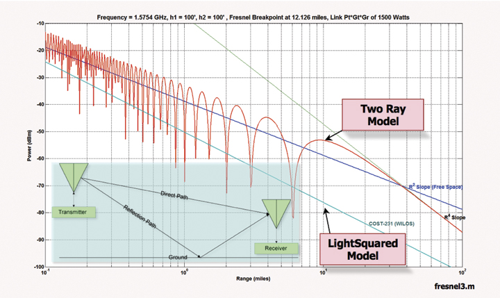
Similarly, don’t play games with statistical propagation modeling. Your proposed Walfish-Ikegami line of sight (WI-LOS) models are wholly inappropriate for low-altitude aircraft using GPS for precision approach and landing. They are based on LOS street-canyon measurements made in the city of Stockholm and are not intended for handsets more than 10 feet off the ground. Two-ray models accounting for ground reflections show LightSquared signals at levels 6 dB above free space predictions several miles out (Figure 1). Live-sky testing at Holloman and Las Vegas showed “above free-space” levels even for some ground mobile users (June 15, 2011, National Public Safety Telecommunications Council [NPSTC] filing with the FCC, page 7, Item 3). Coverage models are not appropriate as safety-of-life models.
Upzoning the entire 1.6-GHz MSS band is not likely any time soon, at least in the United States. Figure out what you can do with less spectrum and less power in the low end of the S-E MSS allocation or find other spectrum; maybe pay for it like other cellular operators did. Don’t forget E-S interference, there are dragons there as well. Develop a transition plan and expect to pay for it.
Figure 1. LightSquared propagation models can underestimate interference by more than a factor of 100 (>20 dB). (Click to enlarge.)
To the GPS Industry: We have long lived in a world of clean, unobstructed spectrum — and it has been wonderful. At this June’s JNC2011 conference, Air Force General Kevin McLaughlin (U.S. Strategic Command) noted that space is increasingly “congested, competitive, and contested.” The same can be said for radio spectrum. LightSquared is trying to make good use of ~68 MHz of largely fallow spectrum straddling ours to provide a valuable and sorely needed wireless data service.
There is no successful business model in providing MSS services only. Motorola and Loral/Qualcomm proved that with their Iridium and Globalstar MSS systems. Both original ventures ended in Chapter 11 bankruptcy. LightSquared is the third or fourth incarnation of Mobile Satellite Ventures (MSV), which ended in bankruptcy. The core business problem is that MSS is expensive to deploy, provides very little capacity (bits/sec/Hz/km2), and these systems offer poor building penetration. Upzoned for terrestrial services (that is, cellular or ancillary terrestrial component, ATC), LightSquared’s spectrum allocation is worth about $15 billion for the license alone at current auction prices, and that’s for only the United States. With spectrum growing increasingly scarce and valuable, we in the GPS industry should expect, and be prepared for, the day when this spectrum is repurposed. It is not my intent to be an apologist for LightSquared, merely to illuminate the fact that this is potentially very valuable spectrum and it is not going to be MSS forever, especially if someone offers to pay for it.
LightSquared was stopped, at least temporarily, by regulatory constraints applicable only within the United States. In effect, the GPS industry lobbied for a 34-MHz guard band and won — maybe. This is not a sustainable position. LightSquared may yet prevail on the international stage and/or in a diminished capability. Also, be aware that in parts of the world interference now makes GPS unusable, for example, Balkan ports and parts of Africa.
We in the GPS industry can and must take steps to improve our ability to operate in congested spectrum. The TWG report showed enormous variations in receiver resistance to out-of-band LightSquared interference. Using a 1-dB C/No degradation criteria, in FAA-certified aviation receivers there was 26 dB of variation in LightSquared signal rejection (Table 3.1.1, page 42). In high-precision receivers, more than 30 dB of variation was seen (Table 10, page 243). Against LightSquared F5L (the lower frequency, 5-MHz-wide LightSquared signal, 1526.3–1531.3 MHz) modulation, high-precision receivers showed more than 70 dB variation in susceptibility to LightSquared interference (TWG Appendix H.1.1.10, Figure 38). Clearly, there are good ways to build a receiver, and bad ways. We need to do better.
Next
Among the steps to consider:
Narrow front-end bandwidths. If you don’t want to be affected by out-of-band jamming, don’t let it in. This is antijamming (AJ) 101. The corollary of course is that most AJ techniques degrade position accuracy, and so it is with filtering. The C/A code is about 2-MHz wide but there are good anti-multipath motivations for using a wider bandwidth. GPS satellites have roughly a 28 to 32 MHz transmission bandwidth. Beyond that, there is nothing except interference. Filter accordingly and don’t forget: antenna selection plays an important role in determining overall receiver frequency selectivity.
Higher 1-dB compression point. Consider designing for a higher 1-dB compression point, particularly if you must use a wider bandwidth front end, say for phase linearity in precision survey receivers or for multipath rejection or for military signals. This also improves IP3 and mitigates intermodulation effects. IP3 is the third-order intercept point of an amplifier and is one of the more important parameters in describing the linear range of an amplifier. Low IP3 leads to higher intermodulation distortion, a process wherein two out-of-band signals can mix with each other in the GPS receiver to produce a third frequency within the GPS band. Yes, higher compression points lead to slightly higher power consumption, but out-of-band signal tolerance improves greatly when combined with downstream filtering. In the longer term, consider adaptive equalization methods.
Use L2C and L5 signals. Currently, nine satellites on orbit broadcast L2C and one broadcasts L5, with another IIF successfully launched July 16. One major reason precision receivers fare poorly against interference is that they require wide front ends to implement codeless and semi-codeless modes to measure L2 carrier phase for widelane ambiguity resolution. Wide bandwidths are also needed to precisely measure L1 pseudorange, again for ambiguity determination. Using L2C/L5 mitigates the need for wide-bandwidth front ends and at the same time creates signal diversity in carrier-phase tracking.
Report interference. One of the most stunning shortcomings in many GPS receivers, both civil and military, is their inability (or unwillingness) to report jamming and spoofing. In my work with DHS on the National Risk Estimate, one recurring theme across industry sectors is how confusing it is when GPS gets jammed. GPS is often deeply integrated with other systems to the point where it becomes invisible until it fails, and then its failure causes weird failure modes in dependant systems. For example, mobile satellite communication systems can fail if the GPS position is wrong; the antenna gets pointed the wrong way. A simple “I am jammed” alert would go a long ways towards diagnosing problems and taking corrective actions. This is as true for LightSquared signals as it is for personal privacy devices.
Integrity Monitoring. If you are lucky, interference causes a signals outage. Some interference types can capture receiver tracking loops and yield false positions. The effects of out-of-band interference on tracking are not well understood. Constantly checking for signal integrity and navigation integrity (for example, receiver-autonomous integrity monitoring) can detect many adverse results without imposing a significant burden on the GPS receiver. The algorithms are well documented. Use them.
Winston Churchill is famously quoted as saying: “Americans can always be counted on to do the right thing — after they have exhausted all other possibilities.” At this point, I think we are still looking at some of the other possibilities and I wouldn’t count the LightSquared situation as a victory for anyone just yet. There is still ample opportunity to snatch defeat from the jaws of victory, but by taking a proactive stance, both politically and technically, we can improve our chances.
Also, a nice pair of wellies might be a good investment; it’s a big barnyard.
Logan Scott has more than 32 years of military and civil GPS systems engineering experience. At Texas Instruments, he pioneered approaches for building high-performance, jamming-resistant digital receivers. While at Omnipoint, a cellular carrier, he developed cross-system interference mitigation strategies. He holds 33 U.S. patents.
Hopefully, you’ve missed my Geospatial Solutions Weekly column which I haven’t written in two months. This past eight weeks, I’ve traveled 20,000 airline miles, driven 5,500 miles, and ridden 300 miles by rail and 300 miles by bus, all through three continents, five countries, and 11 U.S. states. On top of that, I’ve been somewhat consumed by a serious issue you need to know about.
If you or your organization use GPS, you need to know about what is going on with the FCC and a company called LightSquared. There is a very real possibility that your GPS receiver(s) may become obsolete within one year, unless you speak up today. The last day that the FCC will accept comments on this issue is this Saturday, July 30. If you or your organization uses GPS receivers for mobile GIS, you are in the crosshairs of LightSquared and need to speak up to prevent your GPS equipment being rendered obsolete nxt year.
It only takes five minutes of your time to submit your comments to the FCC. You don’t need to write an essay. Here’s what you need to make the FCC aware of:
What you (or the organization you work for) use GPS for.
How much (approximately) your organization has invested in GPS equipment/software.
How much your organization (business or public entity) depends on GPS.
How it would affect your organization (business or public entity) if GPS was interfered with.
If you are worried about not getting approval in time from your department, etc., just keep your comments generic and don’t mention your organization name. The value is the story you tell about how important GPS is to you and your organization, not the specific names.
I suggest composing your comments in a word processor (Word, WordPad, Notepad, etc.) first, then copy/paste to the FCC form so you don’t lose your work in case something goes sideways with the FCC website while you are typing.
Here are simple instructions to submit your comments:
Go to the FCC comment submission website by clicking here.
Type in the following information:
Proceeding Number: 11-109
Name of Filer: Enter your name
Address Line 1: Enter your street address
City: Enter your city
State: Enter your state
Zip: Enter your zip code
Type in or paste your brief comments: Copy/paste your comments
That’s it. Five minutes and you’re done.
If you’d like to peruse the 2,000+ comments that have already been submitted by your peers, you can click here and type in Proceeding# 11-109.
DO NOT take this lightly. I wouldn’t ask you to spend your time on something trivial. DO NOT assume that others are looking out for your best interest; they aren’t. If the FCC approves LightSquared’s application, the high-precision GPS industry, sub-meter to centimeter accurate GPS receivers, will suffer interference from LightSquared’s system.
If you want to read up on this, I’ve written a series of articles you can read.
While I’m eager to write about the places and conferences I’ve been to over the past eight weeks, we need to tend to this very important issue today before it’s too late. If you’re interested in reading my comments to the FCC, the following is what I submitted to the FCC yesterday. Feel free to copy/paste parts you agree with and incorporate them into your comments if you choose.
July 27, 2011
Eric Gakstatter
Editor – GPS World magazine Survey Scene enewsletter
Editor – Geospatial Solutions
High-precision GPS Consultant
PO Box 663
West Linn, OR 97068
Marlene H. Dortch, Secretary
Federal Communications Commission
445 12th Street SW
Washington, DC 20554
Re: IB Docket No. 11-109
Dear Ms. Dortch,
I have serious concerns about LightSquared’s proposal for a nationwide 4G LTE system. I’m afraid that neither LightSquared nor the FCC fully understand the impact of LightSquared’s proposed system on GPS receivers, America’s small businesses, and America’s economy.
As a Contributing Editor to GPS World magazine, my specialty is high-precision GPS receivers, of which I’ve been involved with for more than 20 years as a product developer, power user, and consultant. I’m in touch with tens of thousands of high-precision GPS users from around the world through my newsletter articles (bi-weekly), webinars, and my attendance at technical conferences. I consider myself and I’m considered by others to be an advocate for the high-precision GPS community.
Hundreds of thousands of high-precision GPS receivers in the U.S. are used across many market segments including civil/environmental engineering, construction, land surveying, Geographic Information Systems (GIS), agriculture, forestry, road/rail/airport, hydrography, environmental, water/gas/electric/oil/telecom utilities, mining, bridge/dam monitoring, emergency management, defense & intelligence, higher education, and all levels of Fed/State/Local government.
To illustrate, allow me to describe some examples of how high-p
recision GPS is being used.
In road construction, high-precision GPS offers a 5-to-1 efficiency advantage over legacy construction equipment. Can you imagine the delays if road construction projects took five times longer to complete? California’s Department of Transportation (CALTRANS) currently has 846 construction projects ongoing with construction costs of ~$10.5 billion. High-precision GPS receivers are a critical component of these projects. Projects such as the widening project pictured below, are completed way ahead of schedule. For this reason, CALTRANS has invested in 250 high-precision GPS receivers valued at ~$5 million (~$20,000 per receiver).
CALTRANS Highway 101 project widened the route from four to six lanes to extend the carpool lane for two and a half miles and upgrade a congested interchange in Santa Rosa, six months ahead of schedule
It’s not just large, high-precision GPS receiver deployments that matter. GPS also keeps the public safe.
In Florida, the 5.5 mile Sunshine Skyway Bridge spanning Tampa Bay has five high-precision GPS receivers permanently mounted on it so engineers can monitor the health of the structure. On an annual basis, more than 18 million vehicles travel over the bridge. High-precision GPS is a core technology that ensures the safety of those 18 million vehicles.
The structural integrity of the Sunshine Skyway Bridge over Tampa Bay is continuously monitored by high-precision GPS receivers, ensuring the safety of more than 18 million vehicles per year
It’s not just thousands of public entities that are invested in high-precision GPS technology. Tens of thousands of U.S. small businesses rely on high-precision GPS technology in their daily operations.
A small land surveying firm owner in Virginia says:
“I have relied on GPS for survey grade data for at least 15 years. We use GPS every day for all projects. If GPS becomes unavailable or unreliable it will just about put us out of business. Our $500,000 investment would become worthless.”
A four-person agricultural drainage firm owner states:
“I am president of a small business that relies solely on high accuracy GPS. We do GPS Ag drainage (I and three other employees) we set a base on site all over the state because close proximity RTK correction is the only way to get the vertical accuracy required to do what we do. Any GPS interference immediately closes my business and puts four people out of work.”
Another small land surveying firm says:
“High-precision GPS allows us to obtain measurements between monuments which are miles apart to control land boundaries … in a couple of hours that 20 years ago would required 20 to 30 hours of field crew time. The change in technology comes with our investment of approximately $100,000 which is very significant for a small firm like ours. If we are to wake up here in the next year and find our equipment useless for high-precision GPS, the effects would be devastating to us and our clients in both private development and public infrastructure.”
Finally, high-precision GPS users rely on a complex infrastructure of 7,000+ high-precision, fixed-mount GPS base stations deployed nationwide. The infrastructure began with a few receivers in the early 1990s and has been built upon over the past 18 years by the GPS user community volunteering time, money, equipment, and expertise. It would be impossible to replace all of these receivers since the ownership is so disparate. Many are publicly owned and the rest are commercially owned by businesses and used by people in all the market segments I listed above. To illustrate, one such network consisting of more than 875 high-precision GPS receivers is located in the western United States managed by UNAVCO, a university-governed consortium which is sponsored by the National Science Foundation (NSF), National Aeronautics and Space Administration (NASA), U.S. Geological Survey (USGS), and National Oceanographic and Atmospheric Administration (NOAA).
UNAVCO uses this massive network of high-precision GPS receivers to, among other things, monitor the earth’s crustal plate movement (think earthquake montoring).
Each dot represents a permanently-mounted high-precision GPS receiver that continuously monitors the Earth’s crustal plate movement
Another type of high-precision GPS network is called an RTK networ
k. It delivers real-time, high-precision corrections to engineers, surveyors, Geographic Information Systems (GIS) specialists, construction specialists, and others. This particular network, owned by Keystone Precision Instruments, consists of 178 fixed-mount, high-precision GPS receivers and delivers high-precision GPS corrections to users in New York, Pennsylvania, Maryland, Virginia, Delaware, New Jersey, Connecticut, Vermont, Massachusetts, Rhode Island, New Hampshire, and Maine.
Like the UNAVCO network, the Keystone Precision Instrument RTK Network is a multi-million dollar investment in high-precision GPS infrastructure.
Keystone Precision Instruments’ RTK Network diagram showing 178 fixed-mount, high-precision GPS receivers that provide high-precision GPS corrections to high-precision GPS users in the northeastern U.S.
Recommendations
I’m grateful for this 30-day public comment period as I think it will give the FCC and LightSquared a new perspective on the impact that disrupting high-precision GPS receivers would have on the GPS user community and America’s economy.
Although I’m in favor of a nationwide 4G LTE system, I’m opposed to LightSquared’s proposed plan for the following reasons:
1. The GPS user community knew this was coming and chose to do nothing. This is false. Contrary to what LightSquared asserts, the GPS user community did not know anything about this potential interference until November 2010. LightSquared and the FCC incorrectly assumed that communicating/negotiating with the U.S. GPS Industry Council (USGIC) was the equivalent of communicating/negotiating with the GPS user community. That is a false assumption. The USGIC does not communicate directly with the GPS user community and never has. That’s not its role. I’ve been personally involved in the high-precision GPS industry for 20+ years and writing a monthly newsletter on high-precision GPS technology for GPS World magazine for the past five years. I attend almost every major GPS conference and high-precision GPS market segment conference in the U.S. and some abroad. The first I’d heard about the LightSquared interference issue was November 2010.
Furthermore, there is a clear precedent already set that demonstrates how to handle a case very similar to the current LightSquared situation. In 2008, the U.S. Air Force proposed to discontinue supporting the semicodeless technique that is used by virtually every civilian L1/L2 high-precision GPS receiver in existence. It was the first time in history that an action would render several hundred thousand high-precision GPS receivers obsolete, a scale which is very similar to the impact of the LightSquared system.
There was no industry coalition formed to engage the Air Force. There was no industry outcry. A public/private technical working group was not formed to test the effects on receivers if semicodeless was not supported. Why is that?
The answer is very simple. The U.S. Air Force, to its credit, did a fantastic job of communicating directly with the GPS user community along with the Department of Commerce. It issued public statements describing the impact the action would have on high-precision GPS receivers.
The U.S. Air Force did its homework. At the end of the day, it set a sunset date of December 31, 2020, to discontinue supporting the semicodeless technique. It correctly determined that 12 years is about the amount of time that would allow a smooth transition with a manageable financial impact to the high-precision GPS user community.
Imagine if the U.S. Air Force had set a period of one year to transition away from using the semicodeless technique. That action would have destroyed the high-precision GPS user community resulting in billions of dollars in losses and widespread small business closure. Fortunately, they did their homework, understood the impact, and made the correct decision.
LightSquared, on the other hand, either didn’t do its homework or intentionally kept quiet in order to fly under the radar and push its initiative through before the GPS user community (and others) knew what was happening. In either case, the GPS user community shouldn’t be held accountable in paying for the FCC’s and LightSquared’s lack of communication/notification.
2. The FCC needs to consider future GPS signals as well as satellite signals from other satellite navigation systems. The FCC needs to investigate the effect of the LightSquared system on the future GPS L1C signal as well as GLONASS L1 (Russia), Galileo L1 (Europe), and Compass L1 (Chinese) to understand the effect on receivers of today and of the future. GPS L1C, Galileo L1, and Compass L1 all use wider bandwidth than today’s GPS L1, which makes them even more susceptible to interference from LightSquared’s system.
L1 and L5 are the GPS, GLONASS, Galileo, and Compass signals of the future. Those signals will drive hundreds of billions of dollars in revenue because they will bring high-precision accuracy to our everyday lives, which is something only available on very expensive GPS receivers today.
Again, precedence has been set. Look at what happened to GPS navigation after Selective Availability (SA) was turned off in May 2000. Overnight, GPS accuracy improved from 100 meters to 10 meters, and subsequently the multi-billion dollar market f
or GPS automobile navigation devices was launched. Companies like TomTom grew from zero revenue to multi-billion dollar corporations.
The same is expected to happen again when mainstream GPS accuracy improves from 10 meters to well under a meter using the L1 and L5 signals, but that will only occur if the GPS L1, GLONASS L1, Galileo L1, and Compass L1 signals are protected. Some say that L2 can be used instead of L1 in the future. While that’s true for GPS, L1 and L5 have become the international standard while L2 is not supported by the international community.
3. LightSquared mobile devices are potentially portable GPS jammers. The FCC needs to seriously investigate the interference impact of LightSquared mobile handsets (1626.5-1660.5 Mhz) on GPS receivers. It is already known that Inmarsat (1626.5-1660.5 MHz) devices and Iridium (1616-1626.5 MHz) devices interfere with each other, but Iridium devices are only used in remote areas so it’s not a widespread problem. It is also known that these devices interfere with the GLONASS L1 signal (1597-1605 MHz). We don’t know the extent of the effect that LightSquared mobile devices will have on GLONASS L1, GPS L1, Galileo L1, or Compass L1 signals. The problem is that no LightSquared mobile phones are available to test. Yes, lab simulations can be performed, but LightSquared devices will be made in Asia, among other places, where the designers won’t care one bit about GPS interference. There is not an acceptable design margin, if any, to allow for sloppy LightSquared device designs.
The consequence of LightSquared mobile devices interfering with GPS L1, GLONASS L1, Galileo L1, and Compass L1 is hard to imagine and might be worse than interference from the 40,000 LightSquared towers. Although the LightSquared mobile devices are much lower power (2-3 watts vs. 1,500 watts), LightSquared has announced they intend to deploy more than 250 million mobile devices, which could behave like portable GPS jammers.
Please pay attention this important technical issue that many have chose to ignore.
4. LightSquared needs to permanently abandon using the upper frequency spectrum (1545-1555 MHz) for terrestrial broadcasting. The idea of LightSquared using its licensed upper frequency spectrum (1545-1555 MHz) for terrestrial purpose needs to be permanently abandoned. It’s clear from the test results that this causes widespread GPS interference no matter which class of GPS is used.
Finally, I would like to emphasize that the GPS user community should bear no cost as a result of any interference from LightSquared’s system. The GPS user community was blindsided in November 2010. While you can debate about the communication between the FCC, MSV/Skyterra/LightSquared, and the U.S. GPS Industry Council, no case can be made that the GPS user community knew of MSV/Skyterra/LightSquared’s intentions earlier than late last year, yet the FCC and LightSquared expect the GPS user community to bear the cost of interference caused by LightSquared’s system?
Furthermore, far too little testing has been completed in order to fully understand the impact of LightSquared’s system on GPS receivers. Yes, we have a rough idea of the scale of interference from the test reports submitted in June 2011, but the devil is in the details.
Even if LightSquared only uses the licensed lower spectrum (1526-1536 MHz), as it has proposed as an alternative, the number of high-precision receivers affected would be at least 200,000 at an estimated replacement cost of $10,000 per unit which equates to a total equipment replacement cost of $2 billion dollars. That does not include the cost of removal/installation, lost productivity, required software upgrades, and training. Does the FCC expect the GPS user community to bear that cost?
For the above reasons, I recommend that the FCC deny LightSquared’s request to proceed and encouraged them to use spectrum outside of the MSS band. The resources expended by federal/state/local governments and private corporations to vet LightSquared’s proposal to use the MSS band has run into the tens of millions of dollars, if not more than a one hundred million dollars. I’m afraid the cost of further vetting will double or triple the expenditure as well as result in tremendous opportunity cost as significant resources are expended by public and commercial entities to continue this debate.
Thank you for your attention. If you feel that further testimony is needed, I’m more than happy to oblige.
Sincerely,
/S/ Eric Gakstatter
Eric Gakstatter
Principal – Discovery Management Group LLC
Editor – GPS World Magazine Survey Scene enewsletter
Okay, folks, this is where the rubber meets the road. The FCC public comment period ends this Saturday (July 30). If you use GPS at all, it would be very wise to submit your comments today. Don’t expect the FCC to make a rational decision. There’s a lot of money and political influence in LightSquared’s camp and those can dwarf engineering/technical arguments even if they are overwhleming. The best weapon the GPS user community has is sheer numbers, but we aren’t showing up!
To date (July 27), only 1,896 comments have been submitted. That’s not even close to being enough to get the FCC’s attention, and many of those are aviation and geocaching. Also, you see the politically connected comments (chiefs of police, mayors, state legislators, etc.) are largely in support of LightSquared. That’s because LightSquared is mobilizing its political influence machine.
Submitting your comments to the FCC only takes five minutes. You don’t need to write an essay. Here’s what you need to make the FCC aware of:
What you (or the organization you work for) use GPS for.
How much (approximately) your organization has invested in GPS equipment/software.
How much your organization (business or public entity) depends on GPS.
How it would affect your organization (business or public entity) if GPS was interfered with.
If you are worried about not getting approval in time from your department, etc, just keep your comments generic and don’t mention your organization name. The value is the story you tell about how important GPS is to you and your organization, not the specific names.
I suggest composing your comments in a word processor (Word, WordPad, Notepad, etc.) first, then copy/paste to the FCC form so you don’t lose your work in case something goes sideways with the FCC website while you are typing.
Here are simple instructions to submit your comments:
Go to the FCC comment submission website by clicking here.
Type in the following information:
Proceeding Number: 11-109
Name of Filer: Enter your name
Address Line 1: Enter your street address
City: Enter your city
State: Enter your state
Zip: Enter your zip code
Type in or paste your brief comments: Copy/paste your comments
That’s it. Five minutes and you’re done.
DO NOT assume the Department of Defense, Department of Transportation, the National Telecommunications and Information Administration (NITA) or other organizations that have submitted comments will save the day. They are interested in only protecting their own turf, not yours. I still hear people saying, “The FCC will never let this happen because the Department of Defense or DOT will stop them.” If that was the case, this would have stopped months ago. The further along this goes, the more the following statement rings true (that I wrote back in May):
“The military is going to be accommodated in the name of national security. The aviation industry is going to be accommodated in the name of safety-of-life. The auto navigation industry is going to be accommodated because they are high-profile. The high-precision user is going to be thrown under the bus because we are the most difficult to accommodate (technically) and don’t have a high profile nor are perceived as significant enough to accommodate.”
LightSquared’s latest proposal is to begin using its lower frequency spectrum (1526-1536MHz) first. The departments of Defense, Transportation, and NTIA may bite on this as a compromise for LightSquared’s “good faith effort.” LightSquared says this new plan will accomodate all but 0.5% of GPS receivers. To the FCC, it appears like LightSquared is bending over backwards because they’ve accommodated 99.5% of all GPS receivers. If you didn’t know any better, you’d be impressed, too! The problem for you is that the remaining 0.5% of the GPS receivers are your RTK and high-precision GPS receivers that you’ve spent tens of thousands of your money to purchase! LightSquared’s solution is to have you purchase new equipment.
If you’re interested in reading my comments to the FCC, the following is what I’m submitting to the FCC today. Feel free to copy/paste parts you agree with and incorporate them into your comments if you choose.
July 27, 2011
Eric Gakstatter
Editor – GPS World magazine Survey Scene enewsletter
Editor – Geospatial Solutions
High-precision GPS Consultant
PO Box 663
West Linn, OR 97068
Marlene H. Dortch, Secretary
Federal Communications Commission
445 12th Street SW
Washington, DC 20554
Re: IB Docket No. 11-109
Dear Ms. Dortch,
I have serious concerns about LightSquared’s proposal for a nationwide 4G LTE system. I’m afraid that neither LightSquared nor the FCC fully understand the impact of LightSquared’s proposed system on GPS receivers, America’s small businesses, and America’s economy.
As a Contributing Editor to GPS World magazine, my specialty is high-precision GPS receivers, of which I’ve been involved with for more than 20 years as a product developer, power user, and consultant. I’m in touch with tens of thousands of high-precision GPS users from around the world through my newsletter articles (bi-weekly), webinars, and my attendance at technical conferences. I consider myself and I’m considered by others to be an advocate for the high-precision GPS community.
Hundreds of thousands of high-precision GPS receivers in the U.S. are used across many market segments including civil/environmental engineering, construction, land surveying, Geographic Information Systems (GIS), agriculture, forestry, road/rail/airport, hydrography, environmental, water/gas/electric/oil/telecom utilities, mining, bridge/dam monitoring, emergency management, defense & intelligence, higher education, and all levels of Fed/State/Local government.
To illustrate, allow me to describe some examples of how high-precision GPS is being used.
In road construction, high-precision GPS offers a 5-to-1 efficiency advantage over legacy construction equipment. Can you imagine the delays if road construction projects took five times longer to complete? California’s Department of Transportation (CALTRANS) currently has 846 construction projects ongoing with construction costs of ~$10.5 billion. High-precision GPS receivers are a critical component of these projects. Projects such as the widening project pictured below, are completed way ahead of schedule. For this reason, CALTRANS has invested in 250 high-precision GPS receivers valued at ~$5 million (~$20,000 per receiver).
CALTRANS Highway 101 project widened the route from four to six lanes to extend the carpool lane for two and a half miles and upgrade a congested interchange in Santa Rosa, six months ahead of schedule
It’s not just large, high-precision GPS receiver deployments that matter. GPS also keeps the public safe.
In Florida, the 5.5 mile Sunshine Skyway Bridge spanning Tampa Bay has five high-precision GPS
receivers permanently mounted on it so engineers can monitor the health of the structure. On an annual basis, more than 18 million vehicles travel over the bridge. High-precision GPS is a core technology that ensures the safety of those 18 million vehicles.
The structural integrity of the Sunshine Skyway Bridge over Tampa Bay is continuously monitored by high-precision GPS receivers, ensuring the safety of more than 18 million vehicles per year
It’s not just thousands of public entities that are invested in high-precision GPS technology. Tens of thousands of U.S. small businesses rely on high-precision GPS technology in their daily operations.
A small land surveying firm owner in Virginia says:
“I have relied on GPS for survey grade data for at least 15 years. We use GPS every day for all projects. If GPS becomes unavailable or unreliable it will just about put us out of business. Our $500,000 investment would become worthless.”
A four-person agricultural drainage firm owner states:
“I am president of a small business that relies solely on high accuracy GPS. We do GPS Ag drainage (I and three other employees) we set a base on site all over the state because close proximity RTK correction is the only way to get the vertical accuracy required to do what we do. Any GPS interference immediately closes my business and puts four people out of work.”
Another small land surveying firm says:
“High-precision GPS allows us to obtain measurements between monuments which are miles apart to control land boundaries … in a couple of hours that 20 years ago would required 20 to 30 hours of field crew time. The change in technology comes with our investment of approximately $100,000 which is very significant for a small firm like ours. If we are to wake up here in the next year and find our equipment useless for high-precision GPS, the effects would be devastating to us and our clients in both private development and public infrastructure.”
Finally, high-precision GPS users rely on a complex infrastructure of 7,000+ high-precision, fixed-mount GPS base stations deployed nationwide. The infrastructure began with a few receivers in the early 1990s and has been built upon over the past 18 years by the GPS user community volunteering time, money, equipment, and expertise. It would be impossible to replace all of these receivers since the ownership is so disparate. Many are publicly owned and the rest are commercially owned by businesses and used by people in all the market segments I listed above. To illustrate, one such network consisting of more than 875 high-precision GPS receivers is located in the western United States managed by UNAVCO, a university-governed consortium which is sponsored by the National Science Foundation (NSF), National Aeronautics and Space Administration (NASA), U.S. Geological Survey (USGS), and National Oceanographic and Atmospheric Administration (NOAA).
UNAVCO uses this massive network of high-precision GPS receivers to, among other things, monitor the earth’s crustal plate movement (think earthquake montoring).
Each dot represents a permanently-mounted high-precision GPS receiver that continuously monitors the Earth’s crustal plate movement
Another type of high-precision GPS network is called an RTK network. It delivers real-time, high-precision corrections to engineers, surveyors, Geographic Information Systems (GIS) specialists, construction specialists, and others. This particular network, owned by Keystone Precision Instruments, consists of 178 fixed-mount, high-precision GPS receivers and delivers high-precision GPS corrections to users in New York, Pennsylvania, Maryland, Virginia, Delaware, New Jersey, Connecticut, Vermont, Massachusetts, Rhode Island, New Hampshire, and Maine.
Like the UNAVCO network, the Keystone Precision Instrument RTK Network is a multi-million dollar investment in high-precision GPS infrastructure.
Keystone Precision Instruments’ RTK Network diagram showing 178 fixed-mount, high-precision GPS receivers that provide high-precision GPS corrections to high-precision GPS users in the northeastern U.S.
Recommendations
I’m grateful for this 30-day public comment period as I think it will give the FCC and LightSquared a new perspective on the impact that disrupting high-precision GPS receivers would have on the GPS user community and America’s economy.
Although I’m in favor of a nationwide 4G LTE system, I’m opposed to LightSquared’s proposed plan for the following reasons:
1. The GPS user community knew this was coming and chose to do nothing. This is false. Contrary to what LightSquared asserts, the GPS user community did not know anything about this potential interference until November 2010. LightSquared and the FCC incorrectly assumed that communicating/negotiating with the U.S. GPS Industry Council (USGIC) was the equivalent of communicating/negotiating with the GPS user community. That is a false assumption. The USGIC does not communicate directly with the GPS user community and never has. That’s not its role. I’ve been personally involved in the high-precision GPS industry for 20+ years and writing a monthly newsletter on high-precision GPS technology for GPS World magazine for the past five years. I attend almost every major GPS conference and high-precision GPS market segment conference in the U.S. and some abroad. The first I’d heard about the LightSquared interference issue was November 2010.
Furthermore, there is a clear precedent already set that demonstrates how to handle a case very similar to the current LightSquared situation. In 2008, the U.S. Air Force proposed to discontinue supporting the semicodeless technique that is used by virtually every civilian L1/L2 high-precision GPS receiver in existence. It was the first time in history that an action would render several hundred thousand high-precision GPS receivers obsolete, a scale which is very similar to the impact of the LightSquared system.
There was no industry coalition formed to engage the Air Force. There was no industry outcry. A public/private technical working group was not formed to test the effects on receivers if semicodeless was not supported. Why is that?
The answer is very simple. The U.S. Air Force, to its credit, did a fantastic job of communicating directly with the GPS user community along with the Department of Commerce. It issued public statements describing the impact the action would have on high-precision GPS receivers.
The U.S. Air Force did its homework. At the end of the day, it set a sunset date of December 31, 2020, to discontinue supporting the semicodeless technique. It correctly determined that 12 years is about the amount of time that would allow a smooth transition with a manageable financial impact to the high-precision GPS user community.
Imagine if the U.S. Air Force had set a period of one year to transition away from using the semicodeless technique. That action would have destroyed the high-precision GPS user community resulting in billions of dollars in losses and widespread small business closure
. Fortunately, they did their homework, understood the impact, and made the correct decision.
LightSquared, on the other hand, either didn’t do its homework or intentionally kept quiet in order to fly under the radar and push its initiative through before the GPS user community (and others) knew what was happening. In either case, the GPS user community shouldn’t be held accountable in paying for the FCC’s and LightSquared’s lack of communication/notification.
2. The FCC needs to consider future GPS signals as well as satellite signals from other satellite navigation systems. The FCC needs to investigate the effect of the LightSquared system on the future GPS L1C signal as well as GLONASS L1 (Russia), Galileo L1 (Europe), and Compass L1 (Chinese) to understand the effect on receivers of today and of the future. GPS L1C, Galileo L1, and Compass L1 all use wider bandwidth than today’s GPS L1, which makes them even more susceptible to interference from LightSquared’s system.
L1 and L5 are the GPS, GLONASS, Galileo, and Compass signals of the future. Those signals will drive hundreds of billions of dollars in revenue because they will bring high-precision accuracy to our everyday lives, which is something only available on very expensive GPS receivers today.
Again, precedence has been set. Look at what happened to GPS navigation after Selective Availability (SA) was turned off in May 2000. Overnight, GPS accuracy improved from 100 meters to 10 meters, and subsequently the multi-billion dollar market for GPS automobile navigation devices was launched. Companies like TomTom grew from zero revenue to multi-billion dollar corporations.
The same is expected to happen again when mainstream GPS accuracy improves from 10 meters to well under a meter using the L1 and L5 signals, but that will only occur if the GPS L1, GLONASS L1, Galileo L1, and Compass L1 signals are protected. Some say that L2 can be used instead of L1 in the future. While that’s true for GPS, L1 and L5 have become the international standard while L2 is not supported by the international community.
3. LightSquared mobile devices are potentially portable GPS jammers. The FCC needs to seriously investigate the interference impact of LightSquared mobile handsets (1626.5-1660.5 Mhz) on GPS receivers. It is already known that Inmarsat (1626.5-1660.5 MHz) devices and Iridium (1616-1626.5 MHz) devices interfere with each other, but Iridium devices are only used in remote areas so it’s not a widespread problem. It is also known that these devices interfere with the GLONASS L1 signal (1597-1605 MHz). We don’t know the extent of the effect that LightSquared mobile devices will have on GLONASS L1, GPS L1, Galileo L1, or Compass L1 signals. The problem is that no LightSquared mobile phones are available to test. Yes, lab simulations can be performed, but LightSquared devices will be made in Asia, among other places, where the designers won’t care one bit about GPS interference. There is not an acceptable design margin, if any, to allow for sloppy LightSquared device designs.
The consequence of LightSquared mobile devices interfering with GPS L1, GLONASS L1, Galileo L1, and Compass L1 is hard to imagine and might be worse than interference from the 40,000 LightSquared towers. Although the LightSquared mobile devices are much lower power (2-3 watts vs. 1,500 watts), LightSquared has announced they intend to deploy more than 250 million mobile devices, which could behave like portable GPS jammers.
Please pay attention this important technical issue that many have chose to ignore.
4. LightSquared needs to permanently abandon using the upper frequency spectrum (1545-1555 MHz) for terrestrial broadcasting. The idea of LightSquared using its licensed upper frequency spectrum (1545-1555 MHz) for terrestrial purpose needs to be permanently abandoned. It’s clear from the test results that this causes widespread GPS interference no matter which class of GPS is used.
Finally, I would like to emphasize that the GPS user community should bear no cost as a result of any interference from LightSquared’s system. The GPS user community was blindsided in November 2010. While you can debate whether about the communication between the FCC, MSV/Skyterra/LightSquared, and the U.S. GPS Industry Council, no case can be made that the GPS user community knew of MSV/Skyterra/LightSquared’s intentions earlier than late last year, yet the FCC and LightSquared expect the GPS user community to bear the cost of interference caused by LightSquared’s system?
Furthermore, far too little testing has been completed in order to fully understand the impact of LightSquared’s system on GPS receivers. Yes, we have a rough idea of the scale of interference from the test reports submitted in June 2011, but the devil is in the details.
Even if LightSquared only uses the licensed lower spectrum (1526-1536 MHz), as it has proposed as an alternative, the number of high-precision receivers affected would be at least 200,000 at an estimated replacement cost of $10,000 per unit which equates to a total equipment replacement cost of $2 billion dollars. That does not include the cost of removal/installation, lost productivity, required software upgrades, and training. Does the FCC expect the GPS user community to bear that cost?
For the above reasons, I recommend that the FCC deny LightSquared’s request to proceed and encourage them to use spectrum outside of the MSS band. The resources expended by federal/state/local governments and private corporations to vet LightSquared’s proposal to use the MSS band has run into the tens of millions of dollars, if not more than a one hundred million dollars. I’m afraid the cost of further vetting will double or triple the expenditure as well as result in tremendous opportunity cost as significant resources are expended by public and commercial entities to continue this debate.
Thank you for your attention. If you feel that further testimony is needed, I’m more than happy to oblige.
Sincerely,
/S/ Eric Gakstatter
Eric Gakstatter
Principal – Discovery Management Group LLC
Editor – GPS World Magazine Survey Scene enewsletter
You’ve got to put some in yourself, to get some out.
Don’t expect the FCC to make a rational decision in the Lightsquared versus GPS case. As clear as the conclusions may seem to an engineering mind examining the Technical Working Group’s report on the subject, the Federal Communications Commission does not maintain engineering minds at its top level. That’s the level that makes the decisions, and it is driven by money and politics in equal measure. The only things that will get the FCC’s attention are legislators and strong opposition from citizens.
Comments in the FCC docket so far come largely from the surveying and agriculture communities. The rest of the GNSS industry has not shown up. Individuals count, too, not just companies. Here’s how to make your voice heard, and why. Time’s a-wastin’.
HERE’S HOW.
The FCC will accept public comments on the LightSquared interference with GPS issue until July 30, and replies to those comments until August 15, 2011. After the public comment period is closed, the FCC can render a decision at any time.
Comments may be filed electronically using the Internet by accessing the ECFS.
Follow the instructions provided on the website for submitting comments. First, click “Submit a Filing.” Once the following screen comes us, in the first box labeled "Proceeding Number" enter 11-109. You’ll then be required to enter identifying information into the form and add your comments. In completing the transmittal screen, ECFS filers should include their full name, U.S. Postal Service mailing address, and IB Docket No. 11-109.
Supply information on how you use GPS and what would happen if GPS became unavailable or unreliable. GPS World suggests including comments that state LightSquared’s operations and GPS are fundamentally incompatible and that the FCC should not permit LightSquared to use its mobile satellite services frequency for terrestrial broadcast. You may wish to add that the FCC’s own Technical Working Group tasked with investigating this issue, and the Departments of Defense and Transportation, all agree on this.
It may further be worth adding that GPS is an important, if not vital, resource for a wide range of users — not just yourself or your industry sector. These include many life- and safety-critical applications.
AND HOW.
Whether or not you file a comment by the July 30 deadline (that’s THIS Saturday), I urge you to immediately write on the same subject to both your U.S. senators and to your congressperson in the U.S. House of Representatives.
To find your U.S. senator, go to this website and enter your state in the pull-down menu. You’ll get name, e-mail, phone, and mailing address.
To find your representative in the House, go to this website and proceed similarly.
GNSS community members in Europe, Asia, Africa, Latin America, and elsewhere may write to the U.S. State Department representative tasked in this matter: clorere @ state.gov.
I submit that GPS needs your help, now. If the mothership goes down, the case for other GNSS only becomes more difficult, not less so. And similar attacks may soon be mounted against GNSS internationally, if encouraged by success on this front.
NOW, WHY.
Some troubling trends that I hope will stir you to action:
Troubling Trend Number One. The test results, conclusions, and recommendations of several comprehensive studies, conducted by a combination of industry, government, and independent organizations (NPEF, TWG, RTCA) over a period of months, are currently being questioned, downplayed, dismissed, and/or ignored by FCC and NTIA, while at the same time ad hoc, wild-eyed claims by LightSquared with no substantiation in either fact or test data appear to have attained the same status as gospel truth with these august bodies.
Troubling Trend Number Two. The so-called solution proposed by LightSquared claims to eliminate interference to "99.5 percent" of GPS receivers — although nowhere is this solution supported with any factual basis or evidence whatsoever. When unsubstantiated claims are made in the public arena, one can surmise either or both of two things:
Those making the claims are confident that no one is awake enough or cares enough to examine the claims carefully.
Those making the claims are confident that they have some sort of fix in with the decisive powers — so it doesn’t matter what kind of case they make, as long as there is the semblance of one, transparent or not.
Upsetting Trend Number Three. As to the applications and importance of the "0.5 percent" remaining receivers, we may well ask: How many users and beneficiaries of these "0.5 percent" are there? You know and I know that this number, a wild guess at that, represents the high-precision receivers for which no LightSquared so-called solution will work. The beneficiaries of GPS use in survey, construction, and agriculture certainly number in the hundreds of billions, if not higher.
Ask your better half: Does only 0.5 percent of the U.S. population eat?
Alarming Trend Number Four. LightSquared blandly maintains that it has been around for 10 years or more, and people believe this statement.
Fact: LightSquared bought the assets of a company called SkyTerra, which had great difficulty making its business case work and was thus extremely ripe for acquisition at an attractive price. SkyTerra descended in similar fashion from another company, MSV (Mobile Satellite Ventures), which also had great difficulty making its business case work and was also extremely ripe for acquisition at an attractive price.
Thus, LightSquared’s ancestral history is turbulent. This page gives a fairly good summary of a key episode.
LightSquared says that in 2002 and 2003 it was "operating under a different name." No, those were different companies. Where were the LightSquared executives back then? Working for other companies, that’s where. Hard to be the same company with a different name, different address, and completely different personnel.
If they can’t tell you honestly who they are, how can you trust anything they say?
Nowhere on the LightSquared web site does the company mention its heritage or link to MSV and/or SkyTerra. Instead, it continually speaks about its new vision and how new and novel it is in the world of broadband.
Bald-faced Lying Trend Number Five. LightSquared says that its business plan has been consistent throughout the period from 2002 (the MSV and SkyTerra era) to the present, and people in power at the FCC nod their heads.
No. Not the case. False statement. Lie.
SkyTerra and MSV had business plans that used the "ancillary terrestrial component" (ATC) as the regulators intended, as a gap-filler, with its primary service being provided by satellite. ATC signals could not interfere with satellite signals without undercutting the company’s primary service. This worked for GPS as well.
SkyTerra and MSV went out of business trying to make their business plans work while complying with the ATC requirements.
Enter LightSquared in 2010, with the new broadband vision and the new business plan to — hold fo
r it now — flout ATC requirements, ignore them, demolish them, waive them out of existence, all with the FCC’s willing cooperation.
The LightSquared waiver request of November 2010 upset the heretofore fundamental foundation for even considering ATC in L-band. LightSquared does not provide a primary satellite service, but instead is a terrestrial service — completely different from the business plans of the predecessor companies, and completely at odds with the original intended use of L-band for ATC.
Smelling a Rat in the Smokehouse Trend Number Six. The FCC continues to back LightSquared, to the point of ignoring positions put forward very strongly by top-ranking officials in the U.S Department of Defense, the U.S. Department of Transportation, other U.S. government agencies, Congress, industry and public groups.
Part of this is “because they can." The FCC is a so-called independent agency. However, it is part of the administrative arm of U.S. government, under the direction, appointments, and pleasure of the White House. There are Congressional investigations of FCC contact with the White House (Representative Issa) and on contact with LightSquared (Senator Grassley).
There are numerous reports in various quarters of other close ties between Administration officials and LightSquared.
In that regard, I commend to you these two articles:
Big payday for U.S. ambassador with stake in go-go wireless Internet firm By John Aloysius Farrell and Fred Schulte. July 22, 2011 Donald Gips, the top Obama aide who became ambassador to South Africa, cashed in his stock options for LightSquared, a new wireless Internet firm, for as much as $500,000 ten days after the company won a favorable decision from the Federal Communications Commission, newly released documents show. Gips, a friend and major campaign fundraiser of President Obama, was the White House personnel chief until being appointed ambassador to South Africa in 2009.
Politically-connected LightSquared pushes wireless Internet plan despite GPS concerns LightSquared’s ties to Obama’s supporters and the administration’s policy interests run deep. Several major Democratic campaign contributors and longtime Obama supporters have held investments in the company and its affiliates during its tangled decade of existence.
Obama installed one of his biggest fundraisers, Julius Genachowski, a campaign “bundler” and broadband cheerleader, as chairman of the FCC, which granted LightSquared a special waiver to operate.
“The more that’s revealed, the more questions there are,” said U.S. Sentor Charles Grassley."Without transparency, the public can’t know whose interests the FCC is pursuing and so can’t trust the agency’s work. The FCC should comply with my request for information to uphold the public’s trust.”
A Google Street Car in miniature uses Dexter Industries’ dGPS sensor (Photo courtesy of Mark Crosbie.)
Aspiring engineers, take note. A company dedicated to building robotic sensors for the LEGO Mindstorms NXT system has released a GPS sensor, and a workbook on how to use it.
John Cole, founder of Dexter Industries, explains that his products are intended for the education market, and are “for engineers, scientists, and those aspiring to be.”
“A few months ago, we developed a GPS sensor for the educational market, called the dGPS,” Cole said. The sensor is sold separately, as a third-party product for the LEGO Mindstorms kit.
The dGPS sensor provides GPS coordinate information to a robot and calculates navigation information. It provides latitude, longitude, time, speed, and heading. It also has powerful navigational calculators that can be used to navigate to target coordinates.
The dGPS sensor uses a Skytraq module. The LEGO NXT has limited computing capability and can’t interface directly with a GPS module, so Dexter Industries developed a micro-controller and software that translates and checks the signal from the GPS, and also performs additional calculations and functions for navigational purposes.
Photo courtesy of Mark Crosbie
“For example, in addition to the standard GPRMC string that comes from a GPS chip, our dGPS sensor can receive destination coordinates from the user and calculate distance to destination and angle to destination so they can be matched against a compass,” Cole said. “Also, because robots of this scale are usually traveling below 15 mph, we developed a more accurate compass function that works on the smaller, slower scale.”
The dGPS hooks directly into any of the four sensor ports on the NXT and can be programmed in NXT-G, RobotC, and LeJOS programming languages.
Cole became interested in the Mindstorms system in 2005 while in graduate school. “It’s an incredible robotics kit that really fits with educational curriculums on the high school and junior high levels. The kit lowers the entrance requirements to get started [in engineering], and because it’s based on LEGO, students are usually comfortable getting started with it. It’s deceptively simple, though; the Mindstorms robot can be used to do some pretty powerful stuff.”
Cole’s company had developed a few other sensors for education, including a solar kit and a pressure and temperature sensor, but focused on developing a GPS sensor, Cole said, because it “would be really fun for kids to start using. In particular, things like autonomous vehicles and mapping vehicles have been really exciting to develop and build with this sensor.”
Not Just for Kids. Mark Crosbie, an adult fan of LEGO (the hobbyists refer to themselves as AFOLs), has built a miniature version of the Google street car that roams the streets to photograph them for Google Maps. The car provides panoramic views from various positions along the streets it travels; data is then made accessible through the Street View feature of Google Maps.
Crosbie created his Street View car using Dexter Industries’ dGPS sensor to record coordinates as it drives along. “John has been very supportive of the project, providing great technical assistance to me as I used his sensor,” Crosbie said.
The idea for a miniature Google street car came to Crosbie when he was playing with the dGPS sensor. “I realized that if I combined this sensor with a robust chassis and a camera then I’d have a LEGO version of the famous Google Street View car. And what if I could then upload the pictures into Google Earth,” writes Crosbie on his website. “It all seemed so easy… How wrong I was!”
As Crosbie explains, his miniature Street View car is controlled manually using a PSPNx sensor to receive commands from any standard PSP game controller — the user presses the triangle button on the controller to capture an image and log the GPS coordinates. The cameras provided the biggest challenge. “The keyfob cameras are very temperamental and difficult to mount into standard LEGO dimensions,” he said.
“Every time an image is captured, the current latitude and longitude are recorded from the dGPS,” Crosbie explains. “The NXT creates a KML format file in the flash file system, which is then uploaded from the NXT to a PC. Opening the KML file in Google Earth shows the path that the car drove, and also has placemarks for every picture you took along the way. Click on the placemark to see the picture.”
Despite technical challenges outlined in his blog, Crosbie is undeterred, and working on another prototype. “I’m already hard at work on version 2.0 of the Street View car for a big event later this year.”
How-to Book. Besides hardware, Dexter Industries offers educational support material. “Just last week, we released a book that introduces middle school and high school students to GPS, and how to develop robots that use the GPS,” Cole said.
The book, Beginning GPS for NXT Robots, provides students with an introduction to the basics of GPS, and includes hands-on activities and tutorials on how to use the features of the dGPS sensor with the robots.
“This workbook was written to bring the GPS system to life and help students understand it, explore it, and find new ways to use it,” Cole said.
4-H program’s GPS/GIS program has started to use the company’s sensors in its curriculum, Cole said, because the sensors hook directly into the NXT robots.
The ION Mini-Urban Challenge, in which high school students compete to navigate a LEGO robotic car through a miniature city, don’t use GPS sensors. Students are provided with a kit that contains six other sensors that detect things such as light, color, and sound.
“We would love to be part of the ION challenge and we’ve tried contacting the organizers just recently,” Cole said. “It would be a great fit to get some students using the GPS in a way that really gets kids engaged in GPS/GIS development.”
A Google Street Car in miniature uses Dexter Industries’ dGPS sensor (Photo courtesy of Mark Crosbie.)A street-view photo captured from the on-board cameras of the mini car. (Photos courtesy of Mark Crosbie.)
The head of the European Commission’s Directorate General for Enterprise and Industry, the agency that oversees all operations of the Galileo program, has filed an official comment on the Federal Communications Commission’s (FCC) docket regarding the Lightsquared proposal to broadcast a powerful terrestrial signal. Heinz Zourek addresses Julius Genachowski, FCC chair, as follows:
“I am writing to express our deep concerns about the LightSquared system that is proposed for operation in frequencies immediately below the radionavigation-satellite service (RNSS) allocation at 1559-161OMHz. This band is the core band used by global satellite navigation systems including GPS and you are no doubt aware that Europe is at the advanced planning stage for its own system, Galileo, which will be operational by 2014/15, and that will also use this RNSS allocation.
The band immediately below 1559MHz, allocated by the Radio Regulations to the mobile-satellite service (MSS), has been used for satellite based transmissions for many years and has proved to be broadly compatible with RNSS systems above 1559MHz. The LightSquared proposal for a terrestrial network deployment in MSS spectrum would completely change the nature of radio transmissions in the band. What are now neighbour MSS transmissions at similar receive power levels to RNSS would in future be many orders of magnitude higher and with the potential to severely disrupt reception of RNSS signals.
Analysis carried out in Europe, including by our own technical partner the European Space Agency, has shown that transmissions from LightSquared base-stations do indeed have considerable potential to cause harmful interference to Galileo receivers operating in the United States. Interference effects have been determined to occur in the range 100m to almost 1000km, depending on the type of receiver being used. This obviously presents a grave threat to the viability of providing a Galileo service covering US territory – a service which many studies have shown will not only benefit Galileo users, but those of GPS too as the two systems will be interoperable through a common signal design providing significantly improved coverage and accuracy in urban environments. The European Commission is also concerned about potential impacts to safety critical aviation applications. Europe is covered by the EGNOS system, which is equivalent and interoperable with the US WAAS, and so it is vital that EGNOS/WAAS receivers fitted to aircraft entering US airspace do not suffer degradation to the availability and reception of their navigation signals.
The Galileo system will also contribute to the global COSPAS-SARSAT system through the MEOSAR programme and includes a dedicated space-to-Earth linle in the band 15441545MHz acting as a return channel to distress beacons, in accordance with Article 31 of the Radio Regulations. Intended for the maritime and aviation sector the possibility of disruption to this safety related application within US territory should not be ignored. Whilst recognising that the rules governing worldwide radio usage, enshrined in the ITU Constitution and the Radio Regulations, allow the USA freedom to decide on spectrum matters within its own territory, Article 4 of the Radio Regulations makes it clear that ITU Members States are expected not to cause harmful interference to systems of another country that operate in accordance with the Radio Regulations.
We are confident that the process put in place by the FCC to deal with internal US concerns about the threat to GPS reception will reach appropriate conclusions and that these will take into account our own concerns about reception of Galileo signals. However, the receivers may not have identical characteristics and therefore we would be grateful that Galileo and EGNOS receivers will also be taken into account within the FCC’s decision making process, thus giving us sufficient assurance that users will be able to receive Galileo and WAAS signals in US territory without risk of harmful interference.
The world is spinning in a new direction. Consumers are spending more time on mobile apps than on the web. In June, mobile app use overtook both mobile and desktop web, as measured by apps analytic firm Flurry. Consumers spent an average of 81 minutes per day on mobile apps, and 74 minutes on the web. App use was measured on Apple’s iOS, Android, Blackberry, and J2ME platforms, and web use was measured on the open web, mobile web, and Facebook.
Last year, the numbers told a different story. In 2010 iOS was popular, but Android was yet to skyrocket onto the market. Web time led with 64 daily usage minutes; mobile app time lagged at 43 minutes. What are consumers doing with their apps in 2011? Having fun, or more likely, wasting time. Games and social networking categories captured the significant majority of app usage. Consumers spent nearly half their time playing games, and a third were connecting with social networking apps. Together, these two categories account for 79 percent of consumers’ total mobile app time.
Mapping Apple. Last month I wrote that rumors of Apple’s imminent release of its own mapping database was proven wrong by its renewal of Google maps. This doesn’t mean Google isn’t hard at work on it. MacRumors reports that there are legal disclaimers found in iOS 5 in a new section called “Map Data.” A diverse list of licenses appear from third parties that provide mapping data and services. Included are CoreLogic, Getchee, Increment P Corp, Localeze, MapData Sciences, DMTI, TomTom, Urban Mapping, and Waze. Urban Mapping provides in-depth neighborhood data and Waze offers crowd-sourced real-time map and traffic data.
Foursquare is set to start making money. Foursquare made its name as a location-based check-in community that awards mayoralships and other rewards for visiting stores and restaurants. Users share recommendations for venues. If you wondered how the company was going to bring in revenue, here’s the dope. Foursquare will team with LivingSocial and Gilt Groupe to offer location-targeted daily coupon offers, its biggest move yet to harness its consumer buzz into a long-term revenue model.
Foursquare will leverage its location-tracking capabilities and customer data to offer deals. The depth of Foursquare’s consumer database is extensive and should give the company insight into individual perspectives and behaviors, and provide an edge in targeting offers that will grab a high conversion rate.
LightSquared causes GPS interference. “LightSquared should not be permitted to use the L-Band spectrum for a densely-deployed, non-integrated terrestrial-only network. Such a network would cause unacceptable interference to GPS operations, wiping out an installed base of over 500 million units used in a wide array of public safety, aviation, industrial and consumer applications.” So reads the technical working group’s final report to the FCC. The group concluded that no mitigation techniques, such as using filters on GPS receivers, were considered because they don’t exist and therefore cannot be tested. The FCC is currently holding a comment period and eventually the commission will make a decision about LightSquared band use.
Continuing to press its case, LightSquared presented the FCC with a plan to mitigate interference with GPS by using Inmarsat’s lower spectrum band, enabling reduced power of base stations by more than 50 percent. However, the working group indicated testing of this lower channel does not eliminate harmful interference to GPS receivers.
LightSquared has argued that the issue is with GPS receivers, not their proposed system: “Despite the commercial GPS device industry’s best record to rewrite the record and obfuscate the nature of the problem, the simple fact remains that GPS receivers do not adequately reject base-station transmissions in the adjacent band.” Jim Kirkland of Trimble and the Coalition to Save our GPS responded that GPS receivers were designed against satellite transmissions with an ancillary terrestrial component, consistent with LightSquared’s initial design, but not later changes.
Despite mounting concern of GPS interference, LightSquared recently snared $265 million in financing for its LTE network. This year LightSquared raised a total of $2.3 billion and appears close to a Sprint deal. Does LightSquared have a viable “Plan B”?
Action-based ads. A bit more than a third of mobile ad campaigns ask subscribers to click to call, click to map, click to download, or click to SMS, reports mobile advertiser, Jumptap. The remaining ads usually invite users to a website, and aren’t as immediately actionable. Mobile ad engagement peaks at mid-day, and click through rates are at the lowest during morning commute and initial workday hours.
Moment of Zen. When asked about the stealth in which FourSquare just raised $50 million, CEO Dennis Crowley opined, “Loose Tweets sink companies.”
The exhibit hall is nearly full for the ION GNSS conference in September, and this year’s crop of new products and technology promises to showcase the very latest and greatest. In recent years some companies may have cooled a bit on exhibiting, but this fall has all the earmarks of a resurgence. As a business development guy, the exhibit hall is where I tend to spend most of my time at ION. I like to catch up with each of the companies I’ve done business with and carefully assess how the competition is heating up between the main rivals. This year I sense a slight increase in the number of European exhibitors, so I’m eager to see how far Galileo/EGNOS/GLONASS enthusiasm has been converted into commercial products and services.
Another year has somehow flown by and we’re already preparing for the coming ION conference that will run September 20-23, and it’s once again in Portland, Oregon. I was just in Portland in June and it’s a wonderful city to explore — never seen so many bridges — with a bustling downtown weekend market, great hikes, and that fantastic surface train/bus/tram transportation network to get around. We dropped in on the weekend market under the Burnside Bridge, bought ice-cream, and walked along the pedestrian sidewalks on both sides of the river. The next day we did the T4 trail hike from the Zoo up to a great view of the city from Council Crest, then after lunch at great little Vietnamese restaurant near the huge OHSU campus, down the hill to the waterfront on the cable car and back to the city on surface tram and MAX light rail. Just a wonderful setting for what promises to be yet another successful ION conference at the Portland Convention Center.
I counted 82 of the 88 booths (as of a June 22 ION web update) in the exhibit hall are already taken, with the well-known larger companies all exhibiting as well as several new names who have not exhibited before. In recent years some companies may have been a little cooler on exhibiting at ION, but this year’s crop of product and technology exhibits promise to once more showcase the very latest and greatest in GNSS.
As a business development guy, the exhibit hall is where I tend to spend most of my time at ION. I like to catch up with each of the companies I’ve done business with and carefully assess how the competition is heating up between the main rivals. This year the impression is that there seems to be a slight increase in the number of European exhibitors, so I’m always interested to see how far Galileo/EGNOS/GLONASS enthusiasm has been converted into commercial products and services. I looked hard, but couldn’t readily find any Asian exhibitors, so we may have to wait a while for Compass or QZSS capability to hit this market forum. Of course some of the major Western GNSS companies are already claiming that their receivers are compatible with these Chinese and Japanese systems.
There does seem to be a slew of good-looking papers, and the whole presentation program appears to have a broad spectrum of interesting topics and the potential for new innovations which people want to talk about. It’s always interesting to see how the main players skate through or around the papers — most now seem to hold back and maintain a firmer proprietary outlook, preferring to protect their ideas and innovations — this is perhaps an indication that our industry is becoming much more mature. In the early years, engineers and researchers from the main players seemed to bubble over publicly with reports of leading innovations. Now the industry leaders prefer to patent first and hold things closer to the chest. Nevertheless, the academics, government, and new start-ups promise to provide an entertaining insight into the active investment in research and development that fortunately still seems to be characteristic of our industry.
As for the papers, if you can’t make it to the Civil GPS Service Interface Committee (CGSIC) meetings on the Monday and Tuesday, there will likely be a condensed re-run of the CGSIC constellation updates at John Betz’ panel, which runs through Wednesday morning. I always find these ‘global’ constellation updates to be very broad and somewhat fuzzy, but they do keep you up to date with the latest complexities of fielding and maintaining the systems we rely on. If you want more specifics, there are concurrent sessions on almost every topic throughout the whole week.
The LIghtSquared controversy continues to swirl, even though almost every user, manufacturer, and government agency has decried the threat to GPS, and Congress has forsworn FCC from funding any further activity. Tom Stansell will guide a panel discussion on the topic on Wednesday afternoon. With these two sessions and the manufacturer’s reception in the evening, my Wednesday will be pretty full.
Thursday, I’ll have to find time to browse the exhibits and catch up more with people, but I would like to hear some of the session in the morning on Global and Regional Satellite System Providers & the United Nations ICG, which seems to promise updates on the WAAS-type systems around the world. On the exhibit floor, Locata is making a return to the public scene and there are promises of an open ICD offering compatible operation with GPS, so that’s a must to catch up with.
Then the Thursday evening social evening still remains unclear, but with NovAtel’s bash apparently absent from this year’s ION, I’m sure there will be other interesting events to fit round Navtech’s anticipated open-mike event.
Yes, another ION with the prospect of re-connecting with a whole bunch of people, a great looking technical agenda, a full slate of manufacturers exhibiting, and Portland to explore once again — a conference not to be missed. I must get my membership renewed and register!
Another must-see show for me includes Intergeo, which runs September 27-29 in Nuremberg — but the overlap with ION is hard for me to overcome. But if you can’t make ION, and you want to visit Germany in the late summer, Intergeo is billed as a conference and trade show for geodesy, geoinformation, and land management, with an emphasis on almost every foreseeable way that GNSS is being used around the world. The show is big, with a huge number of exhibitors, and promises 1,500 participants. A “Navigation Conference — Finding your way in the intelligent world” is slated to run concurrently.
ENC-2011, November 29-December 1, is another interesting place to catch up with how Europe views the current status of satellite and other navigation. However, the scope of this meeting, which has in the past been billed as Europe’s answer to ION, has certainly contracted. This year the Royal Institute of Navigation (RIN) is running the conference from the heart of downtown London, and promises 350 delegates, but exhibit space is somewhat limited.