To solve the LightSquared versus GPS controversy, Javad Ashjaee, president and CEO of JAVAD GNSS, has appealed directly to President Obama to discontinue the encryption of P-code, the restricted military GPS signal. His comments came in the context of the LightSquared/GPS interference imbroglio, as part of his solution to the conflict over spectrum. “This policy is not helping national security. It is hurting both precision users and the broadband project. We need more broadband, for global, fast, and inexpensive real-time kinematic (RTK) GPS.”
Ashjaee, a longtime leader in high-precision GNSS equipment, made the remarks during a panel discussion at the Esri Survey Summit, and expands upon them in a video posted on his company’s website: “A Solution for LightSquared.” In the video, he calls the LightSquared saga “a good thing, because it brings the issue of in-band interference to many GPS users, especially surveyors and high-precision users.”
He goes on to address three issues: collateral damage, why high-precision receivers are more affected by the LightSquared attack, and finally a proposed solution to the problem.
In the first section, he disputes the assertion that LightSquared interference to 5 percent (surveyors) and 1 percent (military) of GPS users should be tolerated as collateral damage. “When you add substance to the numbers, you see how quickly this argument fails. The military is the backbone of our national security, and high-precision users are the backbone of our financial security and growth.”
On the second topic, he gives two reasons why high-precision receivers are more affected by the LightSquared signal, briefly summarized here as:
the crucial importance of the arrival time of the signal edges; the edges are first to be distorted by interference. Narrow filters, proposed as a solution by LightSquared, also blur the signal-edge shape.
the encryption of P-code on L1 and L2 bands, degrading their effectiveness by a factor of 1,000, according to Ashjaee. “Encryption does not do any good to anybody.”
As his solution to the problem, Ashjaee says Lightsquared should stay further away from the GPS signal, and use a cascade of filters; secondly, he calls on President Obama to discontinue P-code encryption, at least until the new L2 signal is operable in 8 or 10 years. “This would make GPS less vulnerable to the LightSquared project and others like it.”
In a subsequent conversation with GPS World, Ashjaee likened the P-code situation to that of selective availability (SA), another U.S. government effort to restrict use of high precision. Ashjaee recalled campaigning vigorously against SA in 1991, with full-page ads in GPS World depicting the Mona Lisa painting with many missing parts. “Selective availability is a step backward in providing the best of this excellent work [GPS] of science and art. As the leader in GPS technology, we consider selective availability as being neither good science nor good politics,” the ad copy reads.
Ashjaee adds with a twinkle, “[A former director of the GPS Wing] told me that a high general in the Air Force had that ad pinned to the wall behind his desk. Why? Who knows. Perhaps he agreed with it.”
SA was discontinued in May 2000.
(As an interesting historical side-note, in an adjacent ad in the same January 1991 issue, the company advertised “Ashtech’s True P-Code Advantage.” At that time, P-code was not encrypted. The copy reads:
“GPS was designed as a dual-frequency system and the Ashtech P-12 GPS receiver enables users to take full advantage of GPS capabilities. Dual-frequency reception eliminates ionospheric refraction effects, so medium-to-longer baselines can be measured more accurately.
“High-quality P-code measurements on both bands also enable shroter station occupation time, further increasing productivity for survey crews.”
“P-code correlation produces carrier-phase measurements of higher accuracy because of significantly higher SNR over conventional codeless techniques. This, combined with the P-12 receiver’s ability to measure full-wavelength L2 carier-phase, allows nearly instantaneous integer cycle-phase ambiguity resolution for kinematic survey, precision navigation, and other applications.
“Unlinke conventional codeless techniques, ‘true P-code’ tracking provides inherent immunity from jamming for uninterrupted tracking in areas of high interference.”)
“The U.S. policy of national security and P-code is 30 years old,” Ashjaee resumes. “This policy was devised at the time we were head-to-head in the Cold War with Soviet Union. They had missiles targeted at us, we had missiles targeted at them. That’s why we encrypted the P-code. But this situation is gone. There is now an agreement between Obama and [Russian president] Medvedev that citizens of the two countries can have 3-year visas to visit each other. Our missiles are not targeted at each other.”
“Since the inception of GPS, there is no shred of evidence that GPS has ever been used to attack any U.S. national security, let alone its P-code signals.”
Further, Ashjaee pointed out, “At that time, GLONASS did not exist, and we did not want them to use our system. Now GLONASS exists, and its signal is arguably more robust than GPS.”
Ashjaee called on President Obama to turn off P-code encryption. “This policy is not helping national security. It is hurting both precision users and the LightSquared project, which we all desperately need. We need more broadband. They know the system is not good, and they want to put another clear code [on L2]. It will take 8 or 10 years. Turn off encryption temporarily until we have it. Encryption can be turned on in a fraction of a second whenever needed.”
“Turning off P-code encryption not only makes the GPS signalmore robust to LightSquared, but also protects it against all kind of other interferences, including harmonics of innocent signals like harmonics or radio stations.”
He embraced the use of wideband communication between base and rovers for RTK GPS. “We have base and rovers, with VRS networks. The corrections must be transmitted from base to rovers. Now we have a mess of communications: UHF (different in every country, difficult to certify in every country), spread-spectrum, VHF, Ethernet, WiFi. These are kludgey communications. If we have broadband, similar to Lightsquared, we have RTK globally, fast, and inexpensive.”
In a separate conversation with GPS World, another expert in high-precision use confirmed that “we have worked very hard in the past, when bandwidth was much more expensive, to minimize the bandwidth required to send differential GPS corrections with minimal latency. Sensor fusion has mitigated the latency issue as well. As robotics applications increase, not only base-rover communications but tons of data relevant to precise positioning, sensor fusion, including vision, RF ranging, path planning, mission planning, obstacle detection, and so on, will be needed. Industrial, scientific, and medical (ISM) band spread-spectrum and ultra-wideband (UWB) ranging systems have a lot of problems that 4G systems could alleviate.”
“We need a coalition to save GPS and Lightsquared,” concluded Ashjaee. “It’s a nice complement.”
“Broadband would be a good help to our industry, and to our technology. We want global, universal wideband communication, either through towers or satellites, or through any means to transmit base station or VRS network corrections to rovers.”
Ashjaee offered to debate the P-code encryption issue with representatives from the GPS Wing, State Department, Department of Defense, PNT ExCom, and others, at the annual GPS World Leadership Dinner, held during the ION-GNSS conference each September. “It will be a very lively debate,” he said. “Add Tom Stansell, too. And representative of LightSquared.”
At stake is the high-precision GPS industry as we know it. If LightSquared’s current proposal is approved by the FCC, it will render tens of thousands, and possibly hundreds of thousands of GPS receivers obsolete starting as early as next year. The FCC is accepting public comments until July 30 and replies to those comments until August 15. After the public comment period is closed, the FCC can render a decision at any time. Last weekend, I spoke alongside LightSquared and the Coalition to Save Our GPS in a two-hour panel discussion at the Esri Survey Summit in San Diego. Here’s my report.
Last weekend, I attended the Esri Survey Summit in San Diego. This year was different in that it was combined with the ACSM (American Congress on Surveying and Mapping) annual conference. Part of the conference Plenary on Saturday were 30-minute presentations by LightSquared and the Coalition to Save Our GPS. The following morning (Sunday), there was a two-hour discussion panel on the LightSquared/GPS interference issue, in which I participated.
At stake is the high-precision GPS industry as we know it. If LightSquared’s current proposal is approved by the FCC, it will render tens of thousands, and possibly hundreds of thousands of GPS receivers obsolete starting as early as next year. The FCC is accepting public comments until July 30 (see also instructions at the bottom of this column) and replies to those comments until August 15, 2011. After the public comment period is closed, the FCC can render a decision at any time.
The FCC is clearly biased on the LightSquared/GPS issue favoring LightSquared. There’s a lot of pressure to push the U.S. National Broadband Plan, which includes improving Americans’ accessibility to high-speed wireless connectivity to the Internet. After only 2 ½ weeks on the job, FCC Wireless Telecommunications Bureau Chief Rick Kaplan stated earlier this month that “We need to make sure we aren’t locking out valuable spectrum because of inefficient transmission,” obviously referring to the LightSquared/GPS interference issue.
The LightSquared propaganda machine has been effective in bending the ear of technically-challenged policymakers into believing GPS receivers are using LightSquared’s spectrum without permission, and that GPS receiver designers have known this issue was coming since as early as 1995. Both statements, of course, are not true as I’ve written before, as has GPS World editor Alan Cameron (see LightSquared, FCC Rebuttals Distort Record), and as published on the Coalition to Save Our GPS website.
Last weekend’s Survey Summit was perhaps the best opportunity to date for land surveyors and other high-precision GPS users to speak out and let LightSquared and our policymakers know how crucial high-precision GPS/GNSS receivers are to their operations. The discussion content was very good and our industry clearly made its points, but it was all for naught.
Esri got LightSquared Executive Vice President Jeffrey Carlisle to fly in from Washington D.C. to speak at the plenary and then participate in the discussion panel along with myself, moderator John Matonich (NSPS), Dr. Javad Ashjaee (JAVAD GNSS), Dr. Joe Paiva (consultant), Curt Sumner (ACSM), and Peter Large (Coalition to Save Our GPS). However, it was a lost opportunity. Only fifty or so people attended the discussion panel, and I’m sure Mr. Carlisle flew back to Washington D.C. to report that the high-precision GPS users just rolled over, and they are not nearly the roadblock that might have been anticipated.
LightSquared: 1, High-Precision GPS Users: 0
A few key points from the discussion panel I think are worth noting:
It’s a joke, but LightSquared is probably going to win the argument that the “GPS industry knew this was coming.” It is going to win not because it is correct, but because Jeff Carlisle was an FCC employee for several years and knows which buttons to push at the FCC, where to find documents that are publicly available — but not reasonably accessible to the general public, in my opinion — and how to misrepresent them.
Who is the “GPS industry” that LightSquared and the FCC refer to?
When LightSquared and the FCC refer to the “GPS industry,” they certainly are not referring to the GPS user community (you and I), which is expected to bear a huge financial burden (you and I will need to buy new GPS equipment) if the LightSquared proposal is approved.
In nearly all of its documents, LightSquared refers to discussions and agreements with the U.S. GPS Industry Council (USGIC). I have a problem with this, and so should you. The USGIC is a sort of chamber of commerce for GPS manufacturers. If you perform a Google search for the U.S. GPS Industry Council, you won’t find a website, you won’t find a listing of council members, nor will you find much other information about it.
The USGIC, in other words, does not maintain a high public profile. To be fair, it is an industry council, not a user council.
To be further fair, the Industry Council did negotiate an agreement several years ago with a former version of LightSquared (under different ownership then) and with the FCC, along certain business terms and technical parameters. That agreement did not harm GPS users in any way; in fact, it contained some inherent protections for GPS users. The current version of LightSquared has completely changed both its business plan and those technical parameters — turned them on their heads, as a matter of fact — but blithely continues to claim that this was all worked out and agreed to previously.
Nevertheless, how has it come about that the USGIC was the negotiator with LightSquared and its predecessors for you and I regarding your GPS equipment when you’ve never met a USGIC representative, and never had a chance to provide comments before negotiations with LightSquared and its predecessors on such a critical issue?
When I made a statement about this during our discussion panel, Jeff Carlisle called me a “fear-monger,” if I recall correctly, and he referred to my assertion that the USGIC is a chamber of commerce as “ridiculous.” I think he needs a little education.
The analogy I used was that when Walmart wants to build a store in your town, it does not negotiate with the Chamber of Commerce, because the Chamber of Commerce does not represent the citizens. Walmart negotiates with the City Planning Department and City Planning Commission, which is comprised of citizens of the community, who are directly impacted and must bear the consequence of the development.
The reason LightSquared is in this controversial and expensive predicament today is because it chose the incorrect organization to negotiate with. Perhaps on purpose, so it could maintain later that it had negotiated with someone.
This is not virgin territory. There is a clear precedent on this subject. Do you remember back in 2008 when the U.S. Air Force (GPS stewards) wanted to discontinue supporting the semicodeless technique that is used by virtually every civilian dual frequency GPS receiver in existence? It was the first time in GPS history that an action would render several hundred thousand high-precision GPS receivers obsolete, a scale which is very similar to the effect that the LightSquared system would have on high-precision GPS receivers today.
Do you recall an industry coalition being formed to fight it? Do you recall an industry outcry? Do you recall a technical working group being formed to test the effects on receivers if semicodeless was not supported?
The answer is no.
Why is that
?
The answer is very simple. The U.S. Air Force, to its credit, did a fantastic job of communicating with the GPS user community along with the Department of Commerce. It issued public statements describing the impact the action would have on GPS receivers. It held a public comment period. The following statement from its website succinctly summarizes its approach:
“The Office of Space Commercialization worked hard to raise awareness of the size and significance of the high-end GPS user community, which was poorly understood within the government. The Office collected industry information to quantify the installed base of codeless/semi-codeless GPS equipment, estimate its economic value, and determine an acceptable time frame for its replacement. The Office also issued a request for public comments to receive broad stakeholder feedback.”
In other words, it did its homework. At the end of the day, the U.S. Air Force set a date of December 31, 2020 to discontinue supporting the semicodeless technique. It correctly determined that 12 years is about the correct amount of time that would allow a smooth transition with a manageable financial impact to the GPS user community. Users would naturally upgrade their equipment during that period.
Imagine if the U.S. Air Force had set a period of one year to transition away from using the semicodeless technique. That action would have destroyed the high-precision GPS user community, and the continued adoption of high-precision GPS technology would have been set back for years. Fortunately, it did its homework.
LightSquared, on the other hand, either didn’t do its homework or intentionally kept quiet in order to fly under the radar and push its initiative through before the GPS user community (and others) knew what was happening.
During the discussion panel, I wanted to (and I think I did) make three points very clear:
The high-precision GPS user community did not know this was coming, period.
There was a precedent already set that clearly illustrated how to successfully communicate to the high-precision GPS user community when an action is proposed that would effectively render hundreds of thousands of high-precision GPS receivers obsolete.
The high-precision GPS user community should not bear any cost related to LightSquared implementing its system.
That said, I’m not saying “no” to LightSquared.
I get the 4G wireless broadband argument that LightSquared and the U.S. National Broadband Plan make. I want high-speed internet on my smartphone too. I want my phone to work in elevators and elevator-like environments that LightSquared promises. I think this might be a boost to the economy.
While I’m not saying “no” to LightSquared, I’m saying “no” to LightSquared’s proposal at this moment. There are still waaaaay too many unknown issues to be understood and resolved.
A few of them are:
Even using the lower frequency spectrum in its new proposal (1526-1536MHz), at least tens (maybe hundreds) of thousands of your high-precision receivers will need to be replaced. Who will bear that cost?
More testing is needed to understand exactly what the effect of using only the lower frequency spectrum will have on all types of GPS receivers. That was not LightSquared’s original roll-out plan and therefore wasn’t tested extensively to determine its affect on GPS receivers.
The idea of using the upper frequency (1545-1555MHz) for high-powered terrestrial broadcast needs to be permanently abandoned.
The effect on GLONASS L1, Galileo L1, Compass L1, and GPS L1C need to be extensively tested to understand the effect on GNSS receivers of today and of the future. Galileo L1, Compass L1 and GPS L1C all use wider bandwidth than today’s GPS L1 C/A, which makes them even more susceptible to interference from LightSquared’s system.
A serious effort needs to be made to understand the effect of LightSquared’s mobile devices on GPS/GNSS receivers. LightSquared’s mobile devices will operate in the 1626.5-1660.5MHz frequency spectrum, above the GPS L1 spectrum and GLONASS L1 (~1597-1605MHz). It’s been reported that Inmarsat devices (using LightSquared’s 1626.5-1660.5MHz mobile device spectrum) do not fare well around Iridium phones (1616-1626.5MHz), which is very close to GLONASS L1.
We have to be very careful and test these scenarios because once the plug is pulled, you can’t suck the water back out of the drain. There’s no turning back. Also, the FCC doesn’t have a solid history of making good decisions in the wireless arena. In the words of noted wireless industry guru Andrew Seybold (BlackBerry, HP, AT&T, Motorola):
“The history of wireless is littered with examples where the FCC acted on a request by a vendor, approved the deployment of a system, and later learned that the new system created interference to other services.”
In fact, Mr. Seybold writes that LightSquared shouldn’t be permitted to move forward at all. On July 6, 2011, he published the following:
“Okay, I admit it. I don’t believe LightSquared should be permitted to use what was supposed to be satellite spectrum for a terrestrial broadband network. Not only that, I don’t believe LightSquared has a sound business plan. Building more than 40,000 cell sites, maintaining them, and reselling the bandwidth to others who want to sell it to its customers, does not pencil out in my book. The margins will be too slim, especially given the fact that prices for both voice and broadband services keep falling in the United States so margins will continue to be squeezed. But apart from a faulty business plan, the main reason I am opposed to LightSquared’s plan to build this network is that if there is the slightest chance it will interfere with GPS receivers, it simply should not be permitted to be built.”
To file comments with the FCC: Comments may be filed electronically using the Internet by accessing the ECFS: http://fjallfoss.fcc.gov/ecfs2/. Filers should follow the instructions provided on the website for submitting comments. In completing the transmittal screen, ECFS filers should include their full name, U.S. Postal Service mailing address, and IB Docket No. 11-109.
It is not the best of times as we have been at war for ten years without significant upgrades to the military GPS user equipment supplied to our valiant warfighters. It is not the worst of times as war inexorably draws to a close; now of course come a few military GPS upgrades for which the warfighters have been clamoring for ten years.
Space and CyberSpace Warfare Symposium
The warfighter clamoring has been accomplished for all to hear in warfighter panels at symposia such as I had the honor to attend in Colorado during the month of June. Ski season was still in full swing in selected portions of the Rocky Mountains (it sometimes lingers through July), and many warfighters took advantage of the situation to spend some time on the slopes with their families or play a round of high-altitude golf during the sixth Annual Space and Cyberspace Warfare Symposium held in beautiful Keystone, Colorado, June 14-16, 2011. This symposium, which is sponsored by the Lance P. Sijan Chapter of the Air Force Association, usually attracts about 300+ warfighters and senior decision-makers to the Rocky Mountains to spend time networking and sharing facts and perspectives concerning the war first-hand from warfighters of every description.
In just six years, Kevin Estrem, the current Lance Sijan Chapter president, and his staff have made this the place to be for space and cyberspace warriors as well as the wannabees in the month of June. According to Kevin, the Lance P. Sijan Chapter is one of the largest and most active and award-winning chapters in the AFA, and when you experience the top-flight event they put on for the space and cyberspace warriors every year, it is easy to see why they win so many awards. Timely topics, great venue, great speakers, incredible attention to detail, tremendous service, and an extraordinary venue — how can it not be a great symposium?
Warfighters Run the Gamut
At this space and cyberspace symposium you will see warfighters from across the Department of Defense (DoD) wearing four stars and warfighters with one stripe. The great thing is all are heard and have the opportunity to interact in an incredibly relaxing and collegial atmosphere.
You can opt to play golf with other warfighters, as I mentioned, or exchange thoughts and opinions over the wonderful meals provided by the Keystone Conference Center. Or many, like yours truly, prefer to ride their mountain bikes or just jog along the roaring and cascading Snake River. This year, due to the abundant rainfall in the mountains, the sinuous Snake was running close to flood stage but was contained within its banks, if barely, and that just made it all the most exciting and vociferous. What a sound and what a thrill to ride just inches away from that huge winding and cascading volume of icy cold mountain water. Imagine if you will all the fury of Mother Nature contained in that narrow channel. Breathtaking!
The high mountain backdrop for the Keystone Space and Cyberspace Warfighter Symposium can be both exciting and relaxing at the same time, while still affording everyone opportunities to express their viewpoints in a unique atmosphere. A truly inspiring venue for this type of gathering with more than 100,000 square feet of meeting exhibit and function space.
Nation’s Senior Space Warfighters
The four-star guest and evening banquet speaker at this year’s event was General William L. Shelton (USAF), the Commander of Air Force Space Command. As such General Shelton is officially responsible for organizing, equipping, training, and maintaining mission-ready space and cyberspace forces and capabilities for North American Aerospace Defense Command (NORAD), U.S. Strategic Command (USSTRATCOM), and other combatant commands around the globe. As the senior space warfighter, General Shelton oversees U.S. Air Force network operations; manages a global network of satellite command and control (C2), communications, missile warning, and space launch facilities; and is responsible for space system development and acquisition. He leads more than 46,000 space and cyber professionals, assigned to 88 locations worldwide and deployed to an additional 35 global locations. So you might say he possesses unparalleled qualifications to be the senior warfighter at this year’s warfare symposium.
You might even get the idea that General Shelton likes Colorado, since he began his Air Force career there in 1972 at the United States Air Force Academy (USAFA) and this is his forth assignment to Colorado since that time. But for our purposes in GPS World, one of his most telling Colorado assignments was from August 1990 to June 1992, when he served as the Commander of the 2nd Space Operations Squadron (the folks who fly and maintain the GPS constellation among other things) at Falcon (now Schriever) Air Force Base, Colorado. In fact when I have the opportunity to speak to the space operators at Schriever AFB these days, my old stomping grounds, I quickly remind them that where General Shelton is concerned, almost any topic you broach concerning space operations, especially GPS, he can truthfully say, “Been there…done that,” and he has not the T-shirt, but the stars to prove it.
General Shelton’s Vice Commander, Lt. General Michael Basla (USAF), a lifelong communicator, was also a speaker and attendee again this year. Indeed, Mike has been a regular at this seminal warfighter event since he arrived in Colorado Springs at Peterson AFB. General Basla really knows how to stir up a crowd and he did not disappoint. While both General’s Shelton and Basla had important things to say, it was more important for the warfighters to see them there in person. The presence of the nation’s two senior space warfighters at a symposium for warfighters meant a lot to these brave young men and women, and it showed. All week long I heard the warfighters talking about meeting and getting to hear General Shelton and General Basla speak. A few even hoped to be able to speak to them privately, and they were not disappointed.
General officers do not of course vie to win popularity contests, but if either General Shelton or General Basla were running for public office this year, and the warfighters had their say, the generals would win by a landslide after their presentations and their presence at Keystone.
General Jerome O’Malley Award
The General Jerome F. O’Malley Distinguished Space Leadership Award was awarded to Brigadier General David D. Thompson, the Director of Air, Space and Cyberspace Operations for Air Force Space Command. Mrs. Sharon O’Malley Berg was on hand to present the award and speak about her famous father who many credit for originating the idea of and laying the groundwork for Air Force Space Command.
Warfighter Panel
Nothing Earth-shattering came out of this year’s conference, and that’s probably a good thing, but the highlight had to be the warfighter panels. The young warfighters were exceptional this year; their stories were both heartwarming and heartrending. It is incredible the feats our young warfighters accomplish, whether they are in an F-16 Fighting Falcon or infiltrating Taliban positions as Special Operators on the ground, always in harm’s way. There are space and cyberspace warfighters supporting all the warfighter missions, as space operators in CONUS (Continental U.S.), in the
ater at command positions, and in theater with the Special Operators; heck, as many of us discovered many of them are the Special Operators. I could not have been prouder, and everyone else felt the same way, as was demonstrated by the thundering applause and standing ovation each panel received. If you have never been to one of these events you can justify it by the warfighting panels alone. It is something you will always remember — bravery has that effect.
Memorable
I attend a great many symposia and numerous conferences every year. Sometimes, unfortunately, the venues tend to blend together and you may not even know in what city you are located. However, few if any come close to the ambiance and connectedness of the warfighter symposium at Keystone. You will never mistake it for any other location. The facilities at the Keystone Hotel and Convention Center are first class, and the staff treat the warfighters with special care. More than one of the warfighter panel members, who had just arrived back home from theater, commented that he and his family (yes, the symposium sponsors paid for him to have his family with him) felt like they were in a five-star resort, and it was a much-needed vacation and time together with his family. Many of the warfighters also commented on the extraordinary level of service and the excellent cuisine. For that they have the fantastic magician Angela Andrews, the director of Conference Services and Catering, and her excellent staff at the Keystone Convention Center to thank. Angela and her staff oversee every detail and you do feel pampered. Another distinct advantage of a small but personal and service-oriented symposium in the Rocky Mountains. The cuisine is five-star quality and they have their own pastry chef, which is immediately evident the first morning you partake of the incredible breakfast pastries and treats. Don’t tell my wife, but I’m quite sure I had more than one every morning. It generates a genuine desire to have breakfast for lunch, and breakfast for dinner, if you catch my drift!
Now, I ask you, don’t our warfighters deserve this kind of treatment? From a dark, dank, dangerous, and stinking goat-infested cave in the mountains of Afghanistan, with enemies on every side, to the Keystone Hotel in the beautiful Rocky Mountains where everyone is your friend and supporter. Frankly, it doesn’t seem like too much to me; it just simply seems like the right thing to do. Join us next year won’t you? June 2012, and if you dare, bring your mountain bike.
Joint Navigation Conference (ION-JNC)
Actually, the real name of this conference is a mouthful: The Joint Services Data Exchange (JSDE) and The Institute of Navigation (ION) Annual Joint Navigation Conference (JNC) — or just JNC for short.
For our purposes, the difference between this conference or symposium and the previous warfighter symposium is that papers, presentations, and demonstrations are given by GPS, GIS, and GNSS experts from around the globe on our favorite topics, things to do with positioning, navigation, and timing (PNT).
There are numerous exhibits and an exhibit hall, which will suck you in and never let you go if you allow it to, but only because the exhibits are so interesting. There are of course plenary and general sessions, but basically everyone comes for the individual papers, the research, the camaraderie, the networking, the technical expertise, and the of course the warfighter panels. Indeed, the warfighter panels at this conference are held at the SECRET level each year in a secure location and are limited to citizens of the U.S., U.K., Australia, and Canada. This year the classified events were held in Colorado Springs at Fort Carson, Colorado, one of five military installations in the Colorado Springs area. More on the warfighter panels later.
JNC Venue
This year the JNC ran June 27-30 at the Crowne Plaza Hotel in the Springs, and as I said the classified sessions were held at a separate and secure location.
The accommodations at the Crowne Plaza were barely adequate this year because no one knew the conference would grow so much in popularity. But then when your conference is in demand, attendance will grow, and attendance at the classified sessions alone this year doubled from 300-600 attendees. So the normally unflappable Lisa Beaty that I know and respect at ION and her excellent staff were caught a bit off guard. People typically travel from all over the globe to attend JNC, and this year was no exception. As the numbers mounted, Lisa had a choice between restricting attendance and limiting papers or opening the gates and hoping for the best. The latter choice was the correct one, of course, and in the end it all worked out fine. Some sessions were standing room only and the hotel could not accommodate everyone, but there are numerous excellent hotels in the vicinity. There may have been room for a few more exhibits, but if it grows by as much next year the space may well be maxed out. Such is the price of popularity, and who knows? There may be some hidden space no one noticed. I am sure they will have it all sorted out by next year.
There were few senior officers present this year, although they have frequently been there in the past. But again this is more of a technical and warfighter exchange than it is a policy meeting. Frankly, the people that needed to be there were there, although a few more stars might increase the draw for some potential attendees. Sure, just what Lisa needs right now, a bigger draw! Stars or no stars, if you are a technical PNT geek, this is the conference/symposium for you.
While the presentations generally ran the gamut from good to great (we are generally speaking about engineers here after all), the information exchange and networking that went on were phenomenal to see. There are numerous subject-matter tracks to follow, and only you can decide where you need to be when, but fortunately there are plenty of readily identifiable JNC staff members around to help you find your way.
Presentations
As far as presentations go, the presenters have a stop-light system to help them stay within time limits and ION is ruthless about enforcing it. After all, why wait all day for your favorite presentations just to have them canceled because someone was long winded? This will never happen at JNC. Stars, bars, stripes, mister, or doctor — you have your allotted time for sound and fury on stage and then the hook. It is all very politely accomplished of course, and no one gets the bum rush, but that red light blinking in your face lets you know your allotted time has come to an end. I sincerely wish more conferences ran with this much precision and efficiency. Lisa and her staff are to be congratulated for their Teutonic punctiliousness.
FOUO
I wish I could relate more concerning the excellent FOUO papers; however, ever since 9/11, many JNC presentations have been conducted at the FOUO or For Official Use Only level. Frankly that means that, since this is an international magazine, I cannot relate details of the various presentations. I know some publications blithely ignore that restriction, at their own peril, but you won’t catch me making that mistake. For ION members the papers will be published online at the ION site, and of course you are always free to attend and hear them in person, which is what I hope you will do next year. The presentations are well worthwhile, take my word for it. You can of course peruse the agenda and paper topics at the ION website. When they are posted you should be able to download a cleared version of some of the papers. The papers cover the gamut from an excellent GPS constellation update by Lt. Col. Jennifer Grant (USAF), the current Commander of the 2nd Space Operations Squadron, to something as esoteric as Al
ternative Navigation Technologies (Natural Occurring Phenomena) chaired by my good friend and colleague James Doherty (Capt., USCG Retired) at the Institute for Defense Analysis. Jim is a former President of ION and former Commander of the United States Coast Guard (USCG) NAVCEN (Navigation Center), and for Jim the more esoteric the presentation the better. Jim was also the moderator and organizer of the excellent warfighter panel. He shared the panel duty this year with the immediate past ION President Mickel Miller.
JNC Warfighter Panel
While there is indeed something for everyone at JNC, again the highlight of the event was the final classified day, which included the warfighter panel. And since it was held at the SECRET level I can say almost nothing except that you should have been there. However, Jim Doherty did ask a question of the panel that relates directly to GPS — the question we have been asking of warfighters in this column for the last five years, “If you could have the perfect handheld GPS/communications device, what features would it have?” Not surprisingly, the answers have not changed. The consolidated answer was basically an iPhone-sized device with iPhone weight and battery life with embedded military (SAASM-enabled) PNT and communications capabilities with an Apple- or Garmin-like friendly operating system, and a color screen with maps and multiple grid coordinate systems displaying blue force tracked assets and networking capabilities. In other words, everything the current MUE (like the DAGR) does not do in an iPhone-sized device with an operating system someone could actually enjoy using. There were other specifics, of course, that I cannot go into in this venue. But there were no surprises. The warfighters’ needs have not changed and the DoD continues to not meet them. I thank Jim for asking the question.
In the end the warfighters were simply phenomenal, and there was again thunderous applause, and the only standing ovation of the day, and possibly for the whole conference. If you are reading this in GPS World magazine, then this is not a conference you can afford to miss. I hope to see you in Colorado Springs next June at JNC 2012.
The U.S. Departments of Defense and Transportation declared their strong opposition to the proposal of LightSquared Subsidiary LLC to operate a nationwide broadband service within the spectrum immediately adjacent to GPS signals, in a letter sent on June 14 to the National Telecommunications and Information Administration (NTIA). The agencies acted on behalf of the on behalf of the National Executive Committee for Space-Based Positioning, Navigation, and Timing, which they are responsible for co-chairing.
The Departments asked the NTIA administrator to advise the Federal Communications Commission (FCC) to continue to withhold authorization for LightSquared to commence commercial service per its proposed deployment of a terrestrial service within the 1525-1559 MHz bands. LightSquared’s proposal is to deploy a network of 40,000 base stations along with some satellite coverage over 139 major markets in the United States.
According to their official statement, “The Departments continue to support the National Broadband Plan, but cannot do so at the expense of a global, ubiquitous utility such as the Global Positioning System. The Departments encourage further assessment of any alternative spectrum and/or signal configuration plans.”
The DoD/DoT letter was sent just prior to the original deadline for the final report of the Technical Working Group commissioned by the FCC to research and recommend on this matter. Certainly, the respective signers were cognizant of the contents of that report, at least on the test results regarding interference with GPS. As it turned out, on June 15 LightSquared asked for more time, and was granted a two-week extension. The final report was filed with the FCC on June 30.
The Departments’ position followed an interagency review of the findings of the National Space-Based Positioning, Navigation, and Timing Systems Engineering Forum (NPEF), tasked to assess the GPS impacts of LightSquared’s deployment plan as originally filed. The NPEF determined that, if permitted to operate as originally planned, LightSquared’s signals would significantly interfere with GPS users and, as a result, impact national security, economic security, and public safety nationwide. The NPEF report served as working material for the TWG report.
The NTIA Administrator forwarded the letter and report to the FCC Chairman on July 6. These materials can be found at www.PNT.gov.
Harbinger Capital Partners, the hedge-fund firm that owns wireless-network company LightSquared, which recently launched a frontal assault on the GPS signal, announced on July 6 that its chief operating officer (COO) had resigned by “mutual agreement.” Peter Jenson had been responsible for all operational activities of the funds. His exact role in the application for a Federal Communications Commission (FCC) conditional waiver to broadcast a powerful L1 signal from 40,000 U.S.-based terrestrial cell towers is unknown at this time; however, it is certain to have been key.
Harbinger and LightSquared received a recent rebuff of sorts when the FCC-appointed Technical Working Group filed its final report on June 30, calling for a move of the company’s signal out of the L-Band. Close on the heels of that report came an announcement that the U.S. Departments of Transportation and Defense asked the Administrator of the National Telecommunications and Information Administration to advise the FCC to continue to withhold authorization for LightSquared to commence commercial service per its proposed deployment of a terrestrial service within the 1525-1559 MHz bands.
On that same June 30 date, Harbinger Group Inc., a publicly traded company majority-owned by Harbinger Capital, appointed Omar Asali as acting president, replacing Harbinger founder Phil Falcone, who will continue to serve as chairman and chief executive.
Harbinger faces investor requests to withdraw about $1 billion invested in its funds, The Wall Street Journal reported in June. According to the newspaper, Harbinger told investors withdrawing money that they would be paid in part with stakes in LightSquared; the paper also reported that Harbinger has shrunk to about $6 billion in assets from a peak of $26 billion in 2008.
Asali is a managing director for Harbinger Capital and had previously served as the company’s head of global strategy, so his involvement in the GPS episode is also very probable. The personnel changes cannot be said to reflect a shift away from the contra-GPS initiative. LightSquared rhetoric has actually increased in vehemence on that topic. The moves can be conjectured to be strategic in nature, to satisfy or defuse investor discontent.
It’s July, which means big news is slow to come by — and it is the opportunity to examine what will drive the location-based services market for the rest of 2011…and beyond. So far, consolidation is continuing, with Nokia combining digital mapping giant Navteq into a single LBS unit. In addition, strong entries into the machine-to-machine market include Iridium, while AT&T seeks to increase market share. Privacy issues were a big topic in the first part of the 2011, but will they hamper market growth the rest of the year?
Nokia to Consolidate Navteq into Location-Based Services Unit
In a move that looks like a strategy overhaul, Nokia plans to combine its Chicago-based Navteq digital mapping unit with its location-based services business. The new location and commerce division will be led by Michael Halbherr, who told LBS Insider in April that he was involved in Nokia’s $8.1 billion decision to acquire Navteq in 2007.
Nokia had touted that it had a “hands-off” approach with Navteq, unlike competitor TomTom, which incorporated its Tele Atlas mapping unit so much that the TA brand is no longer visible.
Halbherr told LBS Insider he predicted the demise of the portable navigation system early on, a market that competitor TomTom has been finding difficult recently. Navteq maps power Nokia’s Ovi Maps service for smartphones. Yahoo and Microsoft also incorporate Navteq digital mapping into their offerings.
Privacy Legislation Looks For Consumer Consent
New legislation aims to preclude such companies as Apple and Google from using customer’s location data without their consent. Senators Al Franken, D-Minn., and Richard Blumenthal, D-Conn., co-sponsored the bill, called the Location Privacy Protection Act of 2011.
Franken honchoed a Senate Judiciary Subcommittee on Privacy, Technology, and the Law hearing that grilled Google and Apple executives in May. The uproar about consumer privacy arose in April at a California LBS application developers’ conference when companies indicated that customer’s privacy data was collected and shared.
How this legislation, if passed, will affect the industry is not known. But it has raised eyebrows in several market sectors. Thilo Koslowski, Gartner vice president, told attendees at an automotive telematics conference last month that privacy is a big concern to auto makers who want to incorporate LBS-type of connectivity into their new vehicles. Koslowski went further when he said that not only do consumers not want social media in their vehicles, the privacy factor is not going away — and the industry needs to take notice of that.
Iridium Forging Into M2M Markets
Saying the machine-to-machine market constitutes its fastest growing segment, McLean, Va.-based Iridium Communications has partnered with several industry companies to grow beyond its government markets.
“M2M in 2010 exploded for us in 2010, a real tipping point. In short, we reduced the size of the 9602 [short burst data] module to the size of matchbook, so the much lower price point allowed us to win a bunch of new programs,” said Patrick Shay, Iridium vice president and general manager for data services.
Shay, an industry veteran who worked at Motorola, Rand McNally and Hughes Telematics, said that Iridium plans constellation enhancements in 2015. “It’s a one-for-one [satellite] replacement with backward compatibility and no service disruption,” he said.
Such big M2M names as Kore Telematics, Digi International, and SkyBitz have become Iridium partners. Kore integrates satellite connectivity into its Prismpro unit.
One Iridium partner, DeLorme, said it is rolling out a personal communicator this fall with two-way satellite messaging, SOS capabilities, remote tracking and Android smartphone interface so messages can be posted to Twitter or Facebook. The unit will go for $249.95 and have subscription fees starting at $9.95 a month.
Editor’s Note: The August issue of GPS World will carry an article about Iridium certifying Cubic Global Tracking Solutions’ Global Sentinel System.
AT&T Location Information Services Focusing on Enterprise Market
AT&T Location Information Services is greatly expanding its location marketing, particularly in M2M, with its partners Loc-Aid Technologies and TechnoCom Corp. The company announced the partnerships at its developer summit in January.
The company is focusing on the enterprise market because consumer location-based services have been a tough go for AT&T. The enterprise/M2M market has been a good one for AT&T and its network-based location systems, said John Booth, AT&T LIS senior product manager.
The interoperability with the other carriers helps to grow the market, Booth said. “Historically, a customer had to work with one carrier and that limited them,” he said.
Booth says there are benefits in using a network-based location solution because it prevents users from needing to download applications or use a specific platform in order to be located. The services are both device and network agnostic, he said.
Loc-Aid is working with AT&T on its Location-as-a Service offering where businesses can access a customer’s location based on requirements or events. TechnoCom and AT&T are creating location and messaging products for the enterprise market.
AT&T is working with Road America, a roadside assistance service provider, for a network-based application for location capability in the event of an accident or break down. The service, called LocateMe, is a cross-carrier offering that links to Road America’s 24-hour response centers.
AT&T is working on integrating other location technology into its network service offerings, Booth said. “We are working on a number of applications besides assisted GPS [and cell ID] to include Wi-Fi and RFID. We want something that works in whatever the environment — airports or railroads,” he said.
In addition to call center and transportation logistics, which is AT&T’s strong areas, emerging markets include fraud prevention and even truancy monitoring. “School districts get millions of dollars in funding based on student attendance. It’s a natural location market,” Booth said.
In addition to the truancy monitoring market, regular parolees and bail bond holders constitute a huge potential market. AT&T estimates there are 5 million parolees nationwide and 7 million bail bond holders.
Carriers Still Focal Point for LBS Implementation
For years there have been arguments about who is driving the mobile information market for LBS: Is it the carriers? Auto manufacturers? New media companies such as Google? Despite all of the talk, companies still are trying to align themselves to offer the carriers’ capabilities to implement LBS.
The recent Alcatel-Lucent partnership with Polaris Wireless and Thales Alenia Space is an example of companies tailoring E911 type of location capability and marketing for carriers. The three companies have partnered to pursue business with Tier 1 wireless operators in the United States and other regions, said Bhavin Shah, Polaris Wireless vice president of marketing and business development.
“Alcatel-Lucent and Thales Alenia Space have a working relationship based on the former’s prior part-ownership of the latter. Alcatel-Lucent and Polaris Wireless have pursued a closer relationship based on shared interests in promoting their respective location solutions to wireless operators,” he said. “Recent developments and announcement of the partnership were triggered by impending Tier 1 LTE decisions,
and the fact that the partnership enables a quicker time to market than ALU building a location solution on its own, and Polaris Wireless and Thales Alenia Space approaching Tier 1 operators directly without a larger infrastructure partner.”
Alcatel-Lucent is the platform provider and direct interface with the customer (network operator). ALU provides all hardware, middleware, and conducts sales, support, operations, and billing. Polaris Wireless provides network-based location technology and network interfaces, including Polaris Wireless Location Signatures (Polaris WLSTM) and other location technology, such as Enhanced Cell-ID. Thales Alenia Space, with its expertise in satellite positioning, provides handset-based (GPS) location technology.
Septentrio Satellite Navigation NV and Altus Positioning Systems today announced that the two companies are expanding their strategic relationship to pursue growth opportunities in the high-precision satellite-based surveying sector.
Septentrio is a manufacturer of high-end Global Navigation Satellite System (GNSS) receivers for professional navigation, positioning, and timing applications. Altus is an international supplier of GNSS equipment for survey applications. Both are privately held companies.
Under the agreement, Septentrio is making a substantial investment in Altus through its U.S. subsidiary, Septentrio Inc., which is jointly owned by Septentrio Satellite Navigation NV, and by the Belgische Maatschappij voor Internationale Investering – Société Belge d’Investissement International (BMI-SBI) / Participatiemaatschappij Vlaanderen (PMV), a Belgium-based investment consortium.
“The investment in Altus is an exciting new step in the life of Septentrio,” said Peter Grognard, founder and CEO of Septentrio. “Surveying has traditionally been the largest segment of the professional GNSS industry. Both in traditional and emerging markets, the survey segment has continued to enjoy double-digit growth rates in recent years, and our investment in Altus will further accelerate our growth and expand our global presence in this key industry sector.
“Since the surveying community demands the highest-possible performance in precise measurements, it is a very important driver for GNSS technology,” Grognard said. “Our expanded relationship with Altus will help us refine and improve our products to meet these exacting standards, which will benefit other markets as well, and will create a closer bond between the technology and the marketplace.”
“Based on the analysis performed, LightSquared should not be permitted to use the L-Band spectrum for a densely-deployed, non-integrated terrestrial-only network. Such a network would cause unacceptable interference to GPS operations, wiping out an installed base of over 500 million units used in a wide array of public safety, aviation, industrial and consumer applications. While mitigation techniques utilizing filters were discussed in theory, they could not be tested as part of the WG effort because filters do not exist, even in prototypes. No information considered by the WG demonstrated that any mitigation techniques — other than relocation of the proposed terrestrial network to an alternative band — would be successful.” (From the U.S. GPS Industry Council’s overview of the WG report)
The final report to the Federal Communications Commission (FCC) on three months of research by the technical working group (TWG) tasked to investigate and analyze effects of powerful terrestrial L-band transmitters on the GPS signal and services finally appeared on June 30, nearly two weeks after its assigned date. LightSquared had requested an extension, and apparently the lawyers on its staff used the extra time to write many pages of self-justification and further argumentation of the company’s case. But the facts are clear: the LightSquared signal would devastate services for users of all GPS receivers tested.
The final report is not easy to find on the FCC’s labyrinthine website. Read the full “final report of the Working Group (WG) that was formed to study the GPS overload/desensitization issue as described by the Federal Communications Commission (FCC) in DA 11-133” here.
See also four appendices: one, “Appendix A.1: MOPS Based Procedure for Minimum Recommended Testing of LightSquared RFI to GPS Aviation Receivers” two, “Appendix G.2: from Alcatel-Lucent Labs, LightSquared L-Band GPS Receiver Equipment Impact Evaluation Testing” three, “Appendix H.1.1: JPL/NASA Report on Laboratory Testing of Receivers for the Space-Based Sub-Team and the High Precision Sub-Team”
and four, “Appendix H.1.10: High Precision Receivers – NAVAIR Anechoic Chamber Test Results.”
Full data for all device tests conducted by the Working Group is available for download at: ftp://twg:[email protected]
The TWG conclusions of widespread disruption and harm to GPS services are consistent with those reached by third parties that have reported independent analyses: RTCA, Inc., a Federal Advisory Committee that evaluates aviation, and the National Public Safety Telecommunications Council (NPSTC).
“The TWG faced an extraordinary challenge of trying to determine if the laws of physics would allow the high-power LightSquared signals to co-exist in adjacent radio spectrum with the low-power satellite signals of GPS over and above the complex regulatory challenges of managing spectrum sharing,” said Charles Trimble, chairman of the U.S. GPS Industry Council. “In the end, the laws of physics won out.”
Trimble, who co-chaired the TWG, added, “There is no single, simple solution that can eliminate interference for all classes of GPS receivers in the near term. GPS touches every aspect of our lives. It goes beyond the most widely known navigation applications such as car navigation and cell phones to hugely important applications such as agriculture, electric power grids, communications networks, infrastructure monitoring and construction.”
Regarding possible effective solutions, he offered the view that “greater separation of the LightSquared signals and those of GPS are necessary if the value of GPS is to be protected and broadband communications can grow to its potential over the long term.”
In the area of high-precision receivers used for precision agriculture, survey, construction, machine control, mining, geographic information systems (GIS), structural deformation monitoring, and science, the group found that damaging interference existed at times at very long distances for the LightSquared transmitters. NovAtel president and CEO Michael Ritter said, “Allowing LightSquared to interfere with the utilization of these high precision receivers would eliminate the productivity improvements provided to these industries and applications during the past 20 years and will result in significantly higher prices for goods and services from these industries to the consumer.”
Key Results and Findings from the WG Report:
1. The LightSquared Terrestrial Broadband Service Will Cause Harmful Interference to Nearly All GPS Receivers and GPS-Dependent Applications
2. Limited Testing of LightSquared Terrestrial Broadband Operations in the “Lower” 4G LTE Channel Does Not Eliminate Harmful Interference to GPS Receivers and GPS-Dependent Applications.
3. Increasing Filtering on GPS Receivers Is Not an Available Mitigation Technique.
No Suitable Filters Exist;
Even if Filters Were Available, They Have Undesirable Performance Impacts on GPS Receivers That Have Not Been Evaluated.
Increased Filtering Does Not Mitigate Interference to Hundreds of Millions of GPS Users in the Installed Base.
4. The Only Feasible Solution to the Harmful Interference Effects LightSquared’s Proposed 4G LTE Terrestrial Broadband Service Will Cause to GPS Receivers and GPS-Dependent Applications Is to Relocate the LightSquared Service to Spectrum that is Not Adjacent to GPS/RNSS, outside of the L-Band.
The author stated that his study concentrated on GPS use in precision agriculture, construction, and surveying. It explicitly does not encompass GPS use in aviation, nor in the consumer sector, nor in timing or financial infrastructure.
The report states: “The direct economic benefits of GPS technology on commercial GPS users are estimated to be over $67.6 billion per year in the United States. In addition, GPS technology creates direct and indirect positive spillover effects, such as emission reductions from fuel savings, health and safety gains in the work place, time savings, job creation, higher tax revenues, and improved public safety and national defense. Today, there are more than 3.3 million jobs that rely on GPS technology, including approximately 130,000 jobs in GPS manufacturing industries and 3.2 million in the downstream commercial GPS-intensive industries. The commercial GPS adoption rate is growing and expected to continue growing across industries as high financial returns have been demonstrated. Consequently, GPS technology will create $122.4 billion benefits per year and will directly affect more than 5.8 million jobs in the downstream commercial GPS-intensive industries when penetration of GPS technology reaches 100 percent.
Further, “the GPS industry directly creates jobs and economic activities, which spur economic growth. Evidence shows that innovative industries, such as the GPS industry, create both high- and low-skilled jobs during economic expansions and downturns, pay their employees higher-than-national-average wages, raise output and sales per employee, increase U.S. competitiveness, which is reflected in increased exports and reduced U.S. trade deficits, and spend large sums on R&D and capital investment. In addition to creating these direct economic benefits, innovative industries create productivity benefits to the downstream industries, including increased sales, profits, and investment returns. Empirical studies have shown sustained productivity benefits support further growth and job creation in downstream industries and the U.S. economy as a whole.”
Finally, “The direct economic costs of full GPS disruption to commercial GPS users and GPS manufacturers are estimated to be $96 billion per year in the United States, the equivalent of 0.7 percent of the U.S. economy. This annual total cost is the sum of $87.2 billion and $8.8 billion imposed on commercial GPS users and commercial GPS manufacturers, respectively. GPS user costs consist of $67.6 billion per year in foregone GPS benefits — increased productivity and input cost savings — and another $19.6 billion book value of investment losses in GPS equipment. GPS manufacturer costs consist of $8.3 billion per year in foregone commercial GPS equipment sales and an additional $0.55 billion per year in R&D spending and associated costs to attempt to mitigate the so-called LightSquared Problem.Systemn
“If the operation of LightSquared will disrupt 50 percent of commercial GPS equipment, the direct economic impacts are expected to be $48.3 billion per year. Except the R&D spending and the opportunity cost of R&D spending performed by GPS manufacturers to find attempt to mitigate interference, direct economic costs to commercial GPS users and foregone GPS equipment sales are assumed to be half of total direct costs under the scenario of 100 percent degradation. In addition to direct economic impacts, there are other forgone direct and indirect economic and social benefits that are threatened by the LightSquared Problem. On the macroeconomic level, GPS disruption would reduce productivity and, consequently, hinder the competitiveness of GPS downstream users.”
Figure 1. Revenue shares of GPS equipment in North America, 2005–2010, according to Bone, Dominique and Stuart Carlaw, 2009, “Global Navigation Satellite Positioning Solutions,” ABI Research; and authors’ estimates.
Figure 2. Commercial GPS equipment revenues in North America, 2005–2010, according to Bone, Dominique and Stuart Carlaw, 2009, “Global Navigation Satellite Positioning Solutions,” ABI Research; and authors’ estimates.
“Truth,” wrote Sir Francis Bacon, “is the daughter of time.”
He meant that any account, repeated often enough by different people in different places, at different junctures, eventually becomes accepted as historical fact, or truth, by those with no direct knowledge of the matter.
That’s why it is so important to repudiate and expose lies at every encounter. Never, ever let one pass. Even when it’s the same one that you dispelled yesterday — or thought you had taken care of. One thing about liars, they keep coming back. They don’t give up.
Would you give up, if you had $20 billion at stake?
I wrote an online column on this topic recently: “LightSquared, FCC Rebuttals Distort Record.” These distortions were so blandly crafted that they were picked up and passed on by a number of other parties who should have known better, including at least one colleague of the press who writes for a wireless industry publication.
Come to think of it, you do have $20 billion at stake — and much more. We all do. To the tune of more than $67.6 billion in direct economic benefits in the United States alone, provided by GPS. Or $96 billion per year in direct economic costs should GPS be disrupted. See the System news in this issue, “The Economics of Disruption,” for what you stand to lose.
If you think the recent amendment to the 2012 Budget, cutting off FCC funds in this matter, should settle LightSquared hash, think again. The company is back with a new solution. Same as the old solution. Just with the pieces moved around. And it has taken its game up a notch, signaling intent to apply to the International Telecommunication Union for authority to broadcast powerful terrestrial signals all over the world.
All over the world. Calculate the costs of that. For our international readers, this may mean trouble for GLONASS and Galileo too.
Written to your congresspeople about this? Bravo if you have. Write again. They are not tired of hearing from you. There’s a lot they don’t know, that you do, particularly if you read the news accounts here and online. Forward links freely; they are information-laden and they are there for you to use.
Not written to anyone yet? The headline of this column also served as the title of a novel by Josephine Tey, concerning Richard III, King of England. You know the evil hunchback murderer of Shakespeare’s play? We recall him as such because someone (his rival Henry VII) was particularly adept at lying and getting others, including Shakespeare, to repeat the lie — with none to dispute.
GPS could become a forgotten hunchback of history. Act now.
Mitigation Through Adaptive Filtering for Machine Automation Applications
By Luis Serrano, Don Kim, and Richard B. Langley
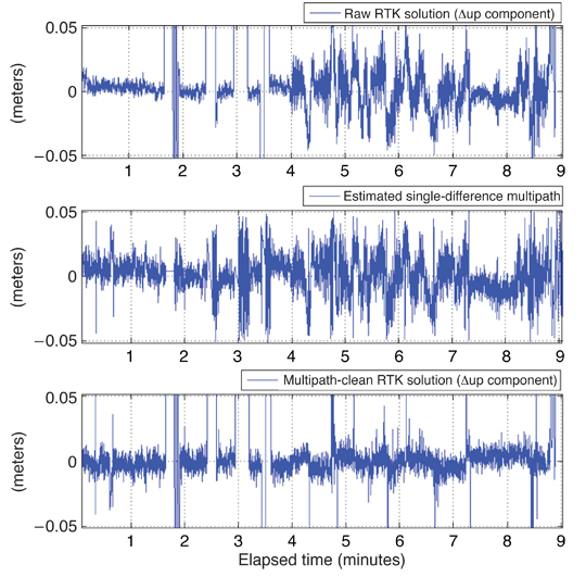
Multipath is real and omnipresent, a detriment when GPS is used for positioning, navigation, and timing. The authors look at a technique to reduce multipath by using a pair of antennas on a moving vehicle together with a sophisticated mathematical model. This reduces the level of multipath on carrier-phase observations and thereby improves the accuracy of the vehicle’s position.
INNOVATION INSIGHTS by Richard Langley
“OUT, DAMNED MULTIPATH! OUT, I SAY!” Many a GPS user has wished for their positioning results to be free of the effect of multipath. And unlike Lady Macbeth’s imaginary blood spot, multipath is real and omnipresent. Although it may be considered beneficial when GPS is used as a remote sensing tool, it is a detriment when GPS is used for positioning, navigation, and timing — reducing the achievable accuracy of results.
Clearly, the best way to reduce the effects of multipath is to try avoiding it in the first place by siting the receiver’s antenna as low as possible and far away from potential reflectors. But that’s not always feasible. The next best approach is to reduce the level of the multipath signal entering the receiver by attenuating it with a suitably designed antenna. A large metallic ground plane placed beneath an antenna will modify the shape of the antenna’s reception pattern giving it reduced sensitivity to signals arriving at low elevation angles and from below the antenna’s horizon. So-called choke-ring antennas also significantly attenuate multipath signals. And microwave-absorbing materials appropriately placed in an antenna’s vicinity can also be beneficial.
Multipath can also be mitigated by special receiver correlator designs. These designs target the effect of multipath on code-phase measurements and the resulting pseudorange observations. Several different proprietary implementations in commercial receivers significantly reduce the level of multipath in the pseudoranges and hence in pseudorange-based position and time estimates. Some degree of multipath attenuation can be had by using the low-noise carrier-phase measurements to smooth the pseudoranges before they are processed. The effect of multipath on carrier phases is much smaller than that on pseudoranges. In fact, it is limited to only one-quarter of the carrier wavelength when the reflected signal’s amplitude is less than that of the direct signal. This means that at the GPS L1 frequency, the multipath contamination in a carrier-phase measurement is at most about 5 centimeters. Nevertheless, this is still unacceptably large for some high-accuracy applications.
At a static site, with an unchanging multipath environment, the signal reflection geometry repeats day to day and the effect of multipath can be reduced by sidereal filtering or “stacking” of coordinate or carrier-phase-residual time series. However, this approach is not viable for scenarios where the receiver and antenna are moving such as in machine control applications. Here an alternative approach is needed.
In this month’s column, I am joined by two of my UNB colleagues as we look at a technique that uses a pair of antennas on a moving vehicle together with a sophisticated mathematical model, to reduce the level of multipath on carrier-phase observations and thereby improve the accuracy of the vehicle’s position.
Real-time-kinematic (RTK) GNSS-based machine automation systems are starting to appear in the construction and mining industries for the guidance of dozers, motor graders, excavators, and scrapers and in precision agriculture for the guidance of tractors and harvesters. Not only is the precise and accurate position of the vehicle needed but its attitude is frequently required as well.
Previous work in GNSS-based attitude systems, using short baselines (less than a couple of meters) between three or four antennas, has provided results with high accuracies, most of the time to the sub-degree level in the attitude angles. If the relative position of these multiple antennas can be determined with real-time centimeter-level accuracy using the carrier-phase observables (thus in RTK-mode), the three attitude parameters (the heading, pitch, and roll angles) of the platform can be estimated.
However, with only two GNSS antennas it is still possible to determine yaw and pitch angles, which is sufficient for some applications in precision agriculture and construction. Depending on the placement of the antennas on the platform body, the determination of these two angles can be quite robust and efficient.
Nevertheless, even a small separation between the antennas results in different and decorrelated phase-multipath errors, which are not removed by simply differencing measurements between the antennas.
The mitigation of carrier-phase multipath in real time remains, to a large extent, very limited (unlike the mitigation of code multipath through receiver improvements) and it is commonly considered the major source of error in GNSS-RTK applications. This is due to the very nature of multipath spectra, which depends mainly on the location of the antenna and the characteristics of the reflector(s) in its vicinity. Any change in this binomial (antenna/reflectors), regardless of how small it is, will cause an unknown multipath effect.
Using typical choke-ring antennas to reduce multipath is typically not practical (not to mention cost prohibitive) when employing multiple antennas on dynamic platforms. Extended flat ground planes are also impractical. Furthermore, such antenna configurations typically only reduce the effects of low angle reflections and those coming from below the antenna horizon.
One promising approach to mitigating the effects of carrier-phase multipath is to filter the raw measurements provided by the receiver. But, unlike the scenario at a fixed site, the multipath and its effects are not repeatable. In machine automation applications, the machinery is expected to perform complex and unpredictable maneuvers; therefore the removal of carrier-phase multipath should rely on smart digital filtering techniques that adapt not only to the background multipath (coming mostly from the machine’s reflecting surfaces), but also to the changing multipath environment along the machine’s path.
In this article, we describe how a typical GPS-based machine automation application using a dual-antenna system is used to calibrate, in a first step, and then remove carrier-phase multipath afterwards. The intricate dynamical relationship between the platform’s two “rover” antennas and the changing multipath from nearby reflectors is explored and modeled through several stochastic and dynamical models. These models have been implemented in an extended Kalman filter (EKF).
MIMICS Strategy
Any change in the relative position between a pair of GNSS antennas most likely will affect, at a small scale, the amplitude and polarization of the reflected signals sensed by the antennas (depending on their spacing). However, the phase will definitely change significantly along the ray trajectories of the plane waves passing through each of the antennas.
This can be seen in the equation that describes the single-difference multipath between two close-by antennas (one called the “master” and the other the “slave”):
(1)
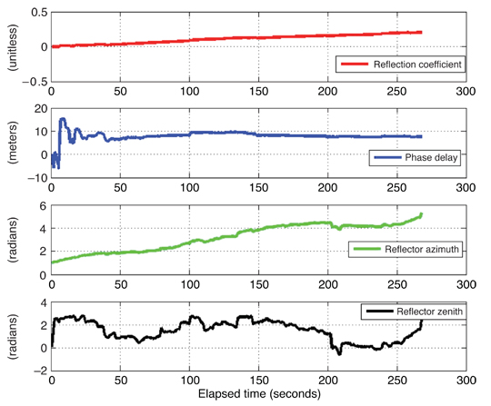
where the angle is the relative multipath phase delay between the antennas and a nearby effective reflector (α0 is the multipath signal amplitude in the master and slave antennas, and is dependent on the reflector characteristics, reflection coefficient, and receiver tracking loop).
As our study has the objective to mimic as much as possible the multipath effect from effective reflectors in kinematic scenarios with variable dynamics, we decided to name the strategy MIMICS, a slightly contrived abbreviation for “Multipath profile from between receIvers dynaMICS.”
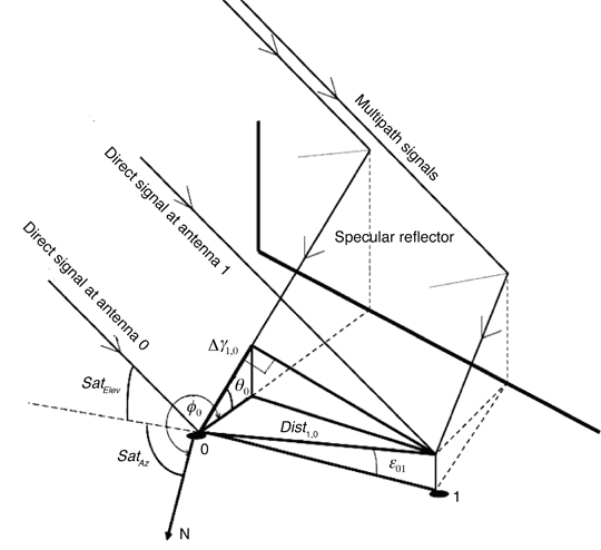
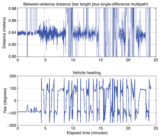
The MIMICS algorithm for a dual-antenna system is based on a specular reflector ray-tracing multipath model (see Figure 1).
Figure 1. 3D ray-tracing modeling of phase multipath for a GNSS dual-antenna system. 0 designates the “master” antenna; 1, the “slave” antenna; Elev and Az, the elevation angle and the azimuth of the satellite, respectively. The other symbols are explained in the text.
After a first step of data synchronization and data-snooping on the data provided by the two receiver antennas, the second step requires the calculation of an approximate position for both antennas, relaxed to a few meters using a standard code solution.
A precise estimation of both antennas’ velocity and acceleration (in real time) is carried out using the carrier-phase observable. Not only should the antenna velocity and acceleration estimates be precisely determined (on the order of a few millimeters per second and a few millimeters per second squared, respectively) but they should also be immune to low-frequency multipath signatures. This is important in our approach, as we use the antennas’ multipath-free dynamic information to separate the multipath in the raw data.
We will start from the basic equations used to derive the single-difference multipath observables.
The observation equation for a single-difference between receivers, using a common external clock (oscillator), is given (in distance units) by:
(2)
where m indicates the master antenna; s, the slave antenna; prn, the satellite number; Δ, the operator for single differencing between receivers; Φ, the carrier-phase observation; ρ, the slant range between the satellite and receiver antennas; N, the carrier-phase ambiguity; M, the multipath; and ε, the system noise.
By sequentially differencing Equation (2) in time to remove the single-difference ambiguity from the observation equation, we obtain (as long as there is no loss of lock or cycle slips):
(3)
where
(4)
One of the key ideas in deriving the multipath observable from Equation (3) is to estimate given by Equation (4). We will outline our approach in a later section.
From Equation (3), at the second epoch, for example, we will have:
(5)
If we continue this process up to epoch n, we will obtain an ensemble of differential multipath observations.
If we then take the numerical summation of these, we will have
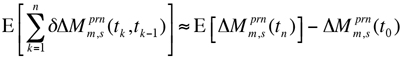
(6)
Note that n samples of differential multipath observations are used in Equation (6). Therefore, we need n + 1 observations.
Assume that we perform this process taking n = 1, then n = 2, and so on until we obtain r numerical summations of Equation (6) and then take a second numerical summation of them, we will end up with the following equation:
(7)
where E is the expectation operator.
Another key idea in our approach is associated with Equation (7). To isolate the initial epoch multipath, , from the differential multipath observations, the first term on the right-hand side of Equation (7), , should be removed.
This can be accomplished by mechanical calibration and/or numerical randomization. To summarize the idea, we have to create random multipath physically (or numerically) at the initialization step. When the isolation of the initial multipath epoch is completed, we can recover multipath at every epoch using Equation (5).
Digital Differentiators. We introduce digital differentiators in our approach to derive higher order range dynamics (that is, range rate, range-rate change, and so on) using the single-difference (between receivers connected to a common external oscillator) carrier-phase observations. These higher order range dynamics are used in Equation (4).
There are important classes of finite-impulse-response differentiators, which are highly accurate at low to medium frequencies. In central-difference approximations, both the backward and the forward values of the function are used to approximate the current value of the derivative.
Researchers have demonstrated that the coefficients of the maximally linear digital differentiator of order 2N + 1 are the same as the coefficients of the easily computed central-difference approximation of order N.
Another advantage of this class is that within a certain maximum allowable ripple on the amplitude response of the resultant differentiator, its pass band can be dramatically increased. In our approach, this is something fundamental as the multipath in kinematic scenarios is conceptually treated as high-frequency correlated multipath, depending on the platform dynamics and the distance to the reflector(s).
Adaptive Estimation. To derive single-difference multipath at the initial epoch, , a numerical randomization (or mechanical calibration) of the single-difference multipath observations is performed in our approach. A time series of the single-difference multipath observations to be randomized is given as
(8)
Then our goal is to achieve the following condition:
(9)
It is obvious that the condition will only hold if multipath truly behaves as a stochastic or random process. The estimation of multipath in a kinematic scenario has to be understood as the estimation of time-correlated random errors. However, there is no straightforward way to find the correlation periods and model the errors.
Our idea is to decorrelate the between-antenna relative multipath through the introduction of a pseudorandom motion. As one cannot completely rely only on a decorrelation through the platform calibration motion, one also has to do it through the mathematical “whitening” of the time series.
Nevertheless, the ensemble of data depicted in the above formulation can be modeled as an oscillatory random process, for which second or higher order autoregressive (AR) models can provide more realistic modeling in kinematic scenarios. (An autoregressive process is simply another name for a linear difference equation model where the input or forcing function is white Gaussian noise.) We can estimate the parameters of this model in real time, in a block-by-block analysis using the familiar Yule-Walker equations. A whitening filter can then be formed from the estimation parameters.
We obtain the AR coefficients using the autocorrelation coefficient vector of the random sequences. Since the order of the coefficient estimation depends on the multipath spectra (in turn dependent on the platform dynamics and reflector distance), MIMICS uses a cost function to estimate adaptively, in real time, the appropriate order. An order too low results in a poor whitener of the background colored noise, while an order too large might affect the embedded original signal that we are interested in detecting.
The cost function uses the residual sum of squared error. The order estimate that gives the lowest error is the one chosen, and this task is done iteratively until it reaches a minimum threshold value. Once this stage is fulfilled, the multipath observable can be easily obtained.
Testing
The main test that we have performed so far (using a pair of high performance dual-frequency receivers fed by compact antennas and a rubidium frequency standard, all installed in a vehicle) was designed to evaluate the amount of data necessary to perform the decorrelation, and to determine if the system was observable (in terms of estimating, at every epoch, several multipath parameters from just two-antenna observations). Receiver data was collected and post-processed (so-called RTK-style processing) although, with sufficient computing power, data processing could take place in real, or near real, time.
In a real-life scenario, the platform pseudorandom motions have the advantage that carrier-phase embedded dynamics are typically changing faster and in a three-dimensional manner (antennas sense different pitch and yaw angles). Thus a faster and more robust decorrelation is possible.
One can see from the bottom picture in Figure 2 the façade of the building behaving as the effective reflector. The vehicle performed several motions, depicted in the bottom panel of Figure 3, always in the visible parking lot, hence the building constantly blocked the view to some satellites. We used only the L1 data from the receivers recorded at a rate of 10 Hz.
In the bottom panel of Figure 3, one can also see the kind of motion performed by the platform. Accelerations, jerk, idling, and several stops were performed on purpose to see the resultant multipath spectra differences between the antennas. The reference station (using a receiver with capabilities similar to those in the vehicle) was located on a roof-top no more than 110 meters away from the vehicle antennas during the test. As such, most of the usual biases where removed from the solution in the differencing process and the only remaining bias can be attributed to multipath. The data from the reference receiver was only used to obtain the varying baseline with respect to the vehicle master antenna.
In the top panel of Figure 3, one can see the geometric distance calculated from the integer-ambiguity-fixed solutions of both antenna/receiver combinations. Since the distance between the mounting points on the antenna-support bar was accurately measured before the test (84 centimeters), we had an easy way to evaluate the solution quality. The “outliers” seen in the figure come from code solutions because the building mentioned before blocked most of the satellites towards the southeast. As a result, many times fewer than five satellites were available.
Figure 3. Correlation between vehicle dynamics (heading angle) and the multipath spectra.
Looking at the first nine minutes of results in Figure 4, one can see that when the vehicle is still stationary, the multipath has a very clear quasi-sinusoidal behavior with a period of a few minutes. Also, one can see that it is zero-mean as expected (unlike code multipath). When the vehicle starts moving (at about the four-minute mark), the noise figure is amplified (depending on the platform velocity), but one can still see a mixture of low-frequency components coming from multipath (although with shorter periods).
These results indicate, firstly, that regardless of the distance between two antennas, multipath will not be eliminated after differencing, unlike some other biases. Secondly, when the platform has multiple dynamics, multipath spectra will change accordingly starting from the low-frequency components (due to nearby reflectors) towards the high-frequency ones (including diffraction coming from the building edges and corners). As such, our approach to adaptively model multipath in real time as a quasi-random process makes sense.
Figure 4. Position results from the kinematic test, showing the estimated distance between the two vehicle antennas (upper plot) and the distance between the master antenna and the reference antenna.
Multipath Observables. The multipath observables are obtained through the MIMICS algorithm. It is quite flexible in terms of latency and filter order when it comes to deriving the observables. Basically, it is dependent on the platform dynamics and the amplitude of the residuals of the whitened time series (meaning that if they exceed a certain threshold, then the filtering order doesn’t fit the data).
When comparing the observations delivered every half second for PRN 5 with the ones delivered every second, it is clear that the larger the interval between observations, the better we are able to recover the true biased sinusoidal behavior of multipath. However, in machine control, some applications require a very low latency. Therefore, there must be a compromise between the multipath observable accuracy and the rate at which it is generated.
Multipath Parameter Estimation. Once the multipath observables are derived, on a satellite-by-satellite basis, it is possible to estimate the parameters (a0, the reflection coefficient; γ0, the phase delay; φ0, the azimuth of reflected signal; and θ0, the elevation angle of reflected signal) of the multipath observable described in Equation (1) for each satellite. As mentioned earlier, an EKF is used for the estimation procedure.
When the platform experiences higher dynamics, such as rapid rotations, acceleration is no longer constant and jerk is present. Therefore, a Gauss-Markov model may be more suitable than other stochastic models, such as random walk, and can be implemented through a position-velocity-acceleration dynamic model.
As an example, the results from the multipath parameter estimation are given for satellite PRN 5 in Figure 5. One can see that it takes roughly 40 seconds for the filter to converge. This is especially seen in the phase delay.
Converted to meters, the multipath phase delay gives an approximate value of 10 meters, which is consistent with the distance from the moving platform to the dominant specular reflector (the building’s façade).
Figure 5. PRN 5 multipath parameter estimation.
Multipath Mitigation. After going through all the MIMICS steps,
from the initial data tracking and synchronization between the dual-antenna system up to the multipath parameter estimation for each continuously observed satellite, we can now generate the multipath corrections and thus correct each raw carrier-phase observation.
One can see in Figure 6 three different plots from the solution domain depicting the original raw (multipath-contaminated) GPS-RTK baseline up-component (top), the estimated carrier-phase multipath signal (middle), and the difference between the two above time series; that is, the GPS-RTK multipath-ameliorated solution (bottom). A clear improvement is visible. In terms of numbers, and only considering the results “cleaned” from outliers and differential-code solutions (provided by the RTK post-processing software, when carrier-phase ambiguities cannot be fixed), the up-component root-mean-square value before was 2.5 centimeters, and after applying MIMICS it stood at 1.8 centimeters.
Figure 6. MIMICS algorithm results for the vehicle baseline from the first 9 minutes of the test.
Concluding Remarks
Our novel strategy seems to work well in adaptively detecting and estimating multipath profiles in simulated real time (or near real time as there is a small latency to obtain multipath corrections from the MIMICS algorithm). The approach is designed to be applied in specular-rich and varying multipath environments, quite common at construction sites, harbors, airports, and other environments where GNSS-based heading systems are becoming standard. The equipment setup can be simplified, compared to that used in our test, if a single receiver with dual-antenna inputs is employed.
Despite its success, there are some limitations to our approach. From the plots, it’s clear that not all multipath patterns were removed, even though the improvements are notable. Moreover, estimating multipath adaptively in real time can be a problem from a computational point of view when using high update rates. And when the platform is static and no previous calibration exists, the estimation of multipath parameters is impossible as the system is not observable. Nevertheless, the approach shows promise and real-world tests are in the planning stages.
Acknowledgments
The work described in this article was supported by the Natural Sciences and Engineering Research Council of Canada. The article is based on a paper given at the Institute of Electrical and Electronics Engineers / Institute of Navigation Position Location and Navigation Symposium 2010, held in Indian Wells, California, May 6–8, 2010.
Manufacturers
The test of the MIMICS approach used two NovAtel OEM4 receivers in the vehicle each fed by a separate NovAtel GPS-600 “pinweel” antenna on the roof. A Temex Time (now Spectratime) LPFRS-01/5M rubidium frequency standard supplied a common oscillator frequency to both receivers. The reference receiver was a Trimble 5700, fed by a Trimble Zephyr geodetic antenna.
Luis Serrano is a senior navigation engineer at EADS Astrium U.K., in the Ground Segment Group, based in Portsmouth, where he leads studies and research in GNSS high precision applications and GNSS anti-jamming/spoofing software and patents. He is also a completing his Ph.D. degree at the University of New Brunwick (UNB), Fredericton, Canada.
Don Kim is an adjunct professor and a senior research associate in the Department of Geodesy and Geomatics Engineering at UNB where he has been doing research and teaching since 1998. He has a bachelor’s degree in urban engineering and an M.Sc.E. and Ph.D. in geomatics from Seoul National University. Dr. Kim has been involved in GNSS research since 1991 and his research centers on high-precision positioning and navigation sensor technologies for practical solutions in scientific and industrial applications that require real-time processing, high data rates, and high accuracy over long ranges with possible high platform dynamics.
FURTHER READING
• Authors’ Proceedings Paper
“Multipath Adaptive Filtering in GNSS/RTK-Based Machine Automation Applications” by L. Serrano, D. Kim, and R.B. Langley in Proceedings of PLANS 2010, IEEE/ION Position Location and Navigation Symposium, Indian Wells, California, May 4–6, 2010, pp. 60–69, doi: 10.1109/PLANS.2010.5507201.
• Pseudorange and Carrier-Phase Multipath Theory and Amelioration Articles from GPS World
“It’s Not All Bad: Understanding and Using GNSS Multipath” by A. Bilich and K.M. Larson in GPS World, Vol. 20, No. 10, October 2009, pp. 31–39.
• Dual Antenna Carrier-phase Multipath Observable
“A New Carrier-Phase Multipath Observable for GPS Real-Time Kinematics Based on Between Receiver Dynamics” by L. Serrano, D. Kim, and R.B. Langley in Proceedings of the 61st Annual Meeting of The Institute of Navigation, Cambridge, Massachusetts, June 27–29, 2005, pp. 1105–1115.
“Mitigation of Static Carrier Phase Multipath Effects Using Multiple Closely-Spaced Antennas” by J.K. Ray, M.E. Cannon, and P. Fenton in Proceedings of ION GPS-98, the 11th International Technical Meeting of the Satellite Division of The Institute of Navigation, Nashville, Tennessee, September 15–18, 1998, pp. 1025–1034.
• Digital Differentiation
“Digital Differentiators Based on Taylor Series” by I.R. Khan and R. Ohba in the Institute of Electronics, Information and Communication Engineers (Japan) Transactions on Fundamentals of Electronics, Communications and Computer Sciences, Vol. E82-A, No. 12, December 1999, pp. 2822–2824.
• Autoregressive Models and the Yule-Walker Equations Random Signals: Detection, Estimation and Data Analysis by K.S. Shanmugan and A.M. Breipohl, published by Wiley, New York, 1988.
• Kalman Filtering and Dynamic Models Introduction to Random Signals and Applied Kalman Filtering: with MATLAB Exercises and Solutions, 3rd edition, by R.G. Brown and P.Y.C. Hwang, published by Wiley, New York, 1997.
Developments in the LightSquared saga came fast and furious in June; highlights are listed below and briefly recapped in the adjacent news story. It will be dated by the time you receive this issue, as it went to press three weeks prior.
For current events, see Top Story and Latest News, and the full versions of stories abridged here. The Navigate, Survey Scene, and GNSS Design & Test e-newsletters, free at env-gpsworld-integration.kinsta.cloud/subscribe, will keep you up to date.
In chronological order, from late May to late June:
LightSquared Las Vegas Test Towers Flawed, FCC Filing Shows
House Bill Ensures FCC Takes No Action that Would Harm Military Use of GPS
Test Data Shows LightSquared Slams Medium, High-Precision GPS Receivers
PNT Advisory Board Finds Interference, Says Move It
LightSquared, FCC Rebuttals Distort Record
NPEF Report on Military Receivers Calls for FCC Recision
LightSquared Asks for, Receives Extension on Final Interference Report
Claims of LightSquared Solution Discounted
Air Transport Association Tells Congress to Protect GPS
Interference with GPS Poses Major Threat to U.S. Economy
LightSquared Applies to International Telecommunications Union for Global Signal
Flawed Test Towers
Results from a key round of field tests conducted near Las Vegas, Nevada, may show overly optimistic results regarding the effects of the LightSquared terrestrial signal on GPS receivers. According to a LightSquared addendum filed with the Federal Communications Commission (FCC) a week after the May 16 Working Group report, the company’s equipment broadcast during the tests at lower-than-planned levels for its eventual deployment across the United States. Further, LightSquared may not currently be prepared or equipped to broadcast according to the terms of its business plan or its conditional waiver.
LightSquared does not appear to have developed the full software suite nor possess the full equipment to implement the plan the company says has been in preparation for many years. Critical testing was conducted under conditions that do not truly replicate what may be the case should the FCC allow the plan to go forward.
House Bills Target the Waiver
On May 27, the U.S. House of Representatives passed a bill stating that the FCC shall not provide final authorization for LightSquared operations until Defense Department concerns about GPS interference have been resolved. The bill then went to the U.S. Senate for its action.
On June 23, the House Appropriations Committee approved action that would stop the FCC from expending any funds related to the LightSquared conditional waiver until all concerns have been resolved about interference with GPS. The amendment passed in a unanimous voice vote by the full committee, underscoring growing congressional concern about harm to GPS.
The House actions and a letter to the FCC signed by 32 U.S. senators may presage a showdown over the issue between Congress and the president, who has promised increased broadband access. A 4G wireless network providing this access could be facilitated by LightSquared sales of service via its tower transmitters to wireless carriers. LightSquared has already signed a $20 billion, 15-year deal with Sprint.
Tests Slam High-Precision Receivers
Data from Las Vegas field tests show that wide-bandwidth, high-precision GPS receivers started feeling the effects of the LightSquared transmission about 1,800 meters from the tower. Medium-bandwidth high-precision GPS receivers started feeling the effects of the LightSquared transmission at about 1,200 meters from the tower. In each case, there was about a 200-meter buffer from when the GPS receivers started to feel the effects of the LightSquared transmission to the GPS receiver being jammed, at 1,600 meters and 1,000 meters respectively.
GPS World has received further details of the tests but has not been authorized to publish them yet.
Deere & Company, a major provider of precision agriculture equipment and services, notified the FCC on May 26 of substantial interference with its GPS receivers by the LightSquared signal. Deere receivers registered impact of and interference by the LightSquared signal as far away as 22 miles from a transmitter. Further, the company has found no practicable technical solution to the problem.
PNT Advisory Board: Move ATC
At its June 9–10 meeting, the National Space-Based Positioning, Navigation and Timing (PNT) Advisory Board found that GPS services cannot be assured if the LightSquared plan is approved, and that the only viable option for continued availability of GPS as well as new wireless broadband is to find another spectrum for LightSquared not adjacent to the GPS frequency.
The formal recommendation reads: “The provision of GPS services cannot be assured if the LightSquared proposal for satellite and terrestrial broadband provision using the MSS L-Band receives final approval.
“The only reasonable and viable option to continue ubiquitous availability of GPS and the provision of a new 4G wireless broadband capability would be for the FCC to assign an alternate frequency spectrum to LightSquared that has little or no probability of affecting the delivery or utilization of GPS/GNSS services.”
During the discussion, one advisory board member, a former goveronor of the state of Wyoming, told presenter Jeff Carlisle of LightSquared, “Your definition of mitigation seems more tied to a legal argument than a common-sense argument.”
Rebuttals Distort Record
Claims by LightSquared’s Carlisle and FCC chair Julius Genachowski, that the GPS industry knew long ago about LightSquared’s plan for powerful terrestrial transmitters, contradict the truth. Examination of FCC filings show that the GPS industry knew about and agreed to a plan by a previous ownership of the company, for a different purpose, with a different business concept, and employing a completely different technological approach, one that would not have harmed GPS transmissions and disabled GPS users the way the current LightSquared plan does.
The terrestrial broadband operations first unveiled in November 2010 cannot be described as ancillary to the purpose for which Lightsquared predecessors Motient, MSV, and SkyTerra received their spectrum and licenses — that is, to provide a service that was primarily a mobile satellite service. The November letter to the FCC described a new business model that turns the original concept on its head. LightSquared for the first time revealed plans to build a “nationwide network of 40,000 terrestrial base stations,” and stated that “the capacity of its fully deployed terrestrial network across all base stations will be tens of thousands of times the capacity of either of [its] satellites.”
The deviations from established policy required to accommodate LightSquared’s new business model are not technicalities. They represent a fundamental change to a complex and interrelated set of rules that were carefully designed to protect GPS users from interference.
The predecessor companies had to protect their own primary satellite operations from interference. The protection that their own satellite operations required was also sufficient — at that time — to protect GPS receivers. The terrestrial network and powerful signal LightSquared now proposes bear no resemblance to the operations the FCC authorized in 2003.
Military Report Calls for FCC Retreat
The National PNT Engineering Forum concluded after testing classified and GPS receivers under LightSquared terrestrial transmission conditions: “Significant concerns remain that operation of an ATC integrated service as originally envisioned by the FCC cannot successfully coexist with GPS.”
The NPEF report calls for rescinding the FCC waiver for LightSquared terrestrial transmissions, conducting more thorough studies on impacts, and revisiting the 2003–2010 authorizations. The group tested a variety of military receivers under classified categorization, also known as “government receivers.”
Final Report Withheld
At the last minute of a June 15 deadline for the final Working Group report on interference, LightSquared asked for a two-week extension. Federal regulators granted the request, and the final report is now due on July 1.
A spokesperson for the Coalition to Save Our GPS revealed that “The Working Group results show devastating interference to GPS and no proven method of mitigation. Delay will not change these results. These results are the same results the FCC had had before it granted the waiver.”
Some Solution. Three days after requesting the delay, LightSquared announced it had solved the problem, by proposing to broadcast only from the lower end of its permitted spectrum band. GPS experts countered that this would still disable the functioning of high-precision receivers.
Air Transport Opposes Waiver
The Air Transport Association and the Aircraft Owners & Pilots Association told Congress that the only acceptable mitigation is for LightSquared’s operations to be moved outside of the L-band and away from GPS. “With so much of the early evidence showing that LightSquared’s proposed network would potentially endanger nearly every flight operating in U.S. airspace, it seems evident that no further development of this system can be allowed.”
Going Global
LightSquared has filed documents relative to the International Telecommunications Union, signaling intent to use its entire band at the full authorized power. The company’s goal appears to be to work internationally, circumventing U.S. regulation, to obtain permits to broadcast a terrestrial signal globally.

 Nation’s Senior Space Warfighters