America’s dependence on GPS is a matter of national security, economic vitality, and daily life. We all agree: the United States must develop strong, resilient alternatives to satellite-based positioning, navigation and timing (PNT). The question, ironically enough, is how to get where we want to go.
Z-Wave Alliance, whose members build the smart home, security, and automation devices used in millions of homes and buildings, fully supports the federal effort to harden PNT infrastructure. We have been active contributors to the FCC’s Notice of Inquiry (WT 25-110) and the Department of Transportation’s Complementary PNT (CPNT) research program. We have provided and assessed technical data to help identify which terrestrial and space-based solutions can truly coexist with the technologies Americans already use every day.
A Known Risk
NextNav has petitioned the FCC to restructure parts of the lower 900 MHzband to host a terrestrial 5G/PNT network—essentially a ground-based GPS complement. The company’s plan would allocate parts of that band for high-power transmissions and relax the long-standing protections that keep low-power (Part 15) devices from destructive interference.
That same spectrum underpins hundreds of millions of existing systems: connected security sensors, toll-booth readers, smart meters, building automation networks, and the smart home products consumers rely on every day. These devices operate safely and efficiently because the FCC’s Part 15 rules limit interference and prohibit high-power operations in this shared public band.
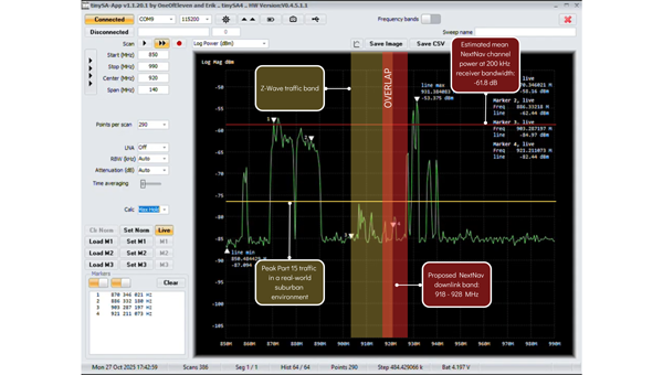
Robust technical analysis, most recently the Pericle Communications study commissioned by the Security Industry Association, shows that high-power terrestrial PNT transmissions would block or degrade low-power communications up to 60 percent of the time. In plain terms, that means alarms that fail to trigger, silent sensors, and lost connectivity for devices that safeguard homes, businesses, and infrastructure.
Evidence indicates these devices could degrade significantly in performance, often to the point of un-usability. Once the band is reclassified, there’s no practical way to “retrofit” the millions of products already deployed. The result would be billions of dollars in stranded hardware, irrecoverable damage to company reputations, and a long, expensive replacement cycle for utilities, business owners, and consumers.
This isn’t an argument against terrestrial PNT. It’s an argument for evidence-based engineering.
— Avi Rosenthal
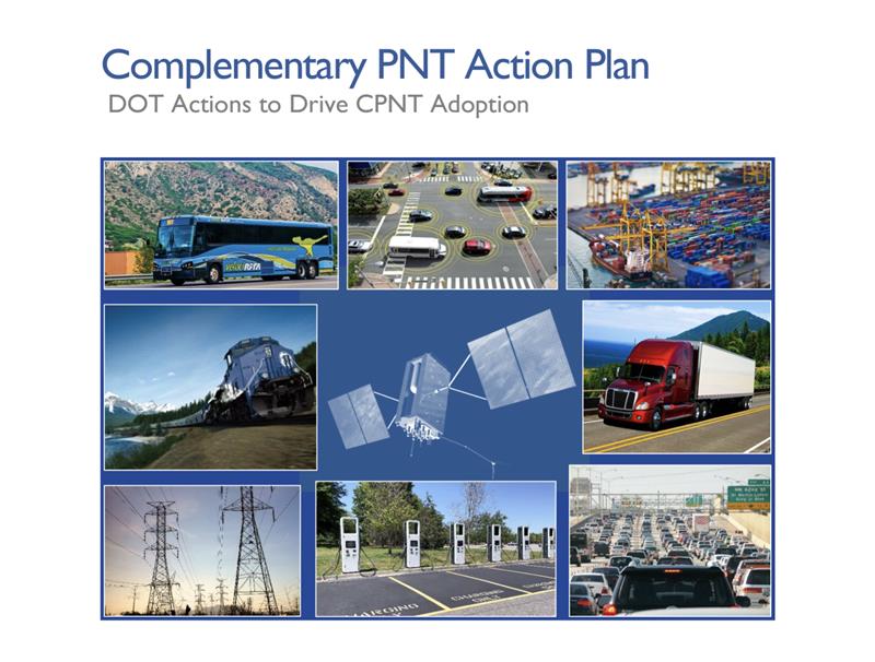
Multiple Paths to Resilient PNT
This isn’t an argument against terrestrial PNT. It’s an argument for evidence-based engineering. The Department of Transportation has identified several categories of GPS-complement technologies, including low-Earth orbit (LEO) satellite systems, time-over-fiber distribution, map matching/map tracking, and terrestrial RF. NextNav’s 900 MHz concept falls into the fourth category, but it’s only one of many.
The FCC recognized this when it opened its broad Notice of Inquiry in March 2025 instead of rushing into rulemaking. Other federally funded trials, such as the Broadcast Positioning System developed by NAB and UrsaNav’s eLoran solution, show that terrestrial PNT can be achieved without displacing unlicensed Part 15 devices.
Engineering redundancy into national infrastructure demands that we test multiple solutions in parallel, not gamble on a single proprietary approach that risks breaking what already works.
Coexistence Is the Standard, Not the Exception
Across every modern wireless domain — Wi-Fi, Bluetooth, Zigbee, Z-Wave, LoRa, Wi-SUN — coexistence testing is standard practice. Before a new technology enters a shared spectrum, it must demonstrate that it can live alongside incumbents. NextNav has not done that. Its coexistence claims rely primarily on simulations using optimistic assumptions about device density and duty cycle. Real-world deployments are far denser and far noisier.
Z-Wave and our industry partners simply ask for what every responsible engineer would: comprehensive, transparent field testing before the FCC alters the rules of a crowded band. That’s not obstructionism: it’s diligence.
Building Forward, Not Backward
Our message is simple: the U.S. needs PNT redundancy, but it must be built on coexistence, not displacement.
America’s connected infrastructure relies on the lower 900 MHz band precisely because it has been open, unlicensed, and reliable. Allowing a single licensee to flood that band with high-power signals would trade resilience for fragility.
Z-Wave Alliance stands ready to collaborate with the FCC, DOT, and all research participants to ensure the U.S. gets the GPS backup it deserves: one that strengthens, rather than undermines, the technologies that keep Americans safe, secure, and connected every day. To learn more, follow Z-Wave Alliance on LinkedIn and across social platforms: we are committed to keeping the U.S. technology community up-to-date on key proposal developments and opportunities to make their voices heard.