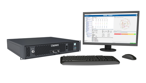
Spirent Communications, now part of Keysight Technologies, announced PNT Xe, a GNSS simulation platform designed to expand high-performance GNSS testing across the development lifecycle. The platform aims to reduce barriers to positioning, navigation and timing testing by offering simulation capabilities in what the company describes as an economical, multipurpose platform.
The company said PNT Xe addresses challenges manufacturers face in validating GNSS performance during accelerated development schedules. The platform’s hardware supports testing from early prototypes through production line verification for commercial and military applications.
“Until now, many organizations have been forced to use unreliable, inconsistent simulators or utilize ‘live sky’ signals as a way of conducting production testing,” said Peter Terry-Brown, divisional CEO of Spirent’s positioning business. He said PNT Xe makes the company’s simulation technology available for workstations, engineers and project phases.
Terry-Brown said the platform allows developers, integrators, design verification teams and production line testers to use consistent test methodology without compromising results validity. Many leading GNSS chipsets and modules are developed using Spirent’s simulators, he said.
The compact PNT Xe can be rack or desk mounted and features an interface designed to accelerate scenario creation. The platform can operate in lab or field environments and withstand variations in temperature and vibration while maintaining performance, according to the company. It supports all GNSS constellations and frequencies and includes AES M-Code access and a removable system disk for secure testing environments.
Rob VanBrunt, CEO of Spirent Federal Systems, called PNT Xe “a game-changer for defense customers.” He said the platform’s ease of use will help deploy new PNT technology faster, allowing software engineers to test code changes at their desks. Authorized GPS M-Code users can conduct unclassified military signal testing using AES M-Code without relying solely on secure labs, he said.
Marie Hattar, chief marketing officer at Keysight Technologies, said accurate, high-performance simulation becomes critical as positioning and timing technologies become foundational to 6G, defense systems and autonomous vehicles. PNT Xe makes that capability available to more innovators to validate performance, reliability and resilience at every development stage, she said.
Built on Spirent’s 40 years of expertise, PNT Xe is designed for development and production environments including low-altitude drones, vehicles, space applications, automotive, defense, and consumer devices.
The Spirent PNT X. (Photo: Spirent Federal Systems)
Developers and manufacturers of GNSS receivers have always needed to simulate the signals from GNSS satellites to test receivers in their labs and in the field. Now, as the vital role of GNSS for critical infrastructure and the growing threat of radiofrequency attacks are increasingly recognized, simulators must keep up. In particular, they must enable users to test a variety of new positioning, navigation and timing (PNT)signals from satellites in low-Earth orbit (LEO) and geostationary orbit (GEO), as well as realistically simulate sophisticated jamming and spoofing attacks.
In this cover story on simulators, we discuss these challenges with experts at four simulator manufacturers:
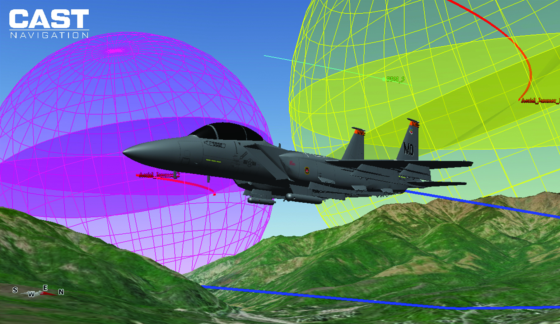
John Clark, Vice President, Engineering, CAST Navigation
Lisa Perdue, Product Line Director, Safran Federal Systems
Jan Ackermann, Director Product Line Management, Spirent Communications, and Paul Crampton, Senior Solutions Architect, Spirent Federal Systems
Avag Tsaturyan, Systems Engineer, M3 Systems.
How are the missions/applications of simulators changing?
Clark: Our customers have been requesting larger simulation systems that can support GNSS and inertial navigation systems (INS) on multiple vehicles simultaneously. Each vehicle is required to support a phased-array (CRPA) antenna sub-system, multiple INS interfaces and signal interference capabilities. This is a change from earlier times when our customers required smaller systems with less capability.
Perdue: We see a growing focus on testing NAVWAR scenarios and assessing receiver performance against diverse threats. The increasing complexity of receivers with multiple constellations and frequencies demands more advanced simulation capabilities. We provide comprehensive PNT simulators that support hybrid scenarios, in which simulated signals and threats are combined with live signals and sensors, creating a dynamic and realistic testing environment.
Crampton:For many years, simulators have been used to prove the capability of receivers and the systems into which the receivers are integrated. Testing ensures that receivers can perform as expected, including performance in boundary cases, which are tricky to recreate in live-sky conditions.
Over time, threats to navigation and timing performance began to dominate the schedules of test labs. Ensuring reliable performance in suboptimal operating environments is critical to receiver users. The workload of test labs has increased to the point where test automation has become necessary, not only in terms of increased efficiency but also just to keep pace with rapidly evolving threat profiles.
So, one of the main changes we are seeing is the need to speed up the innovation cycle with simplified, automated testing while maintaining test fidelity and robustness. Spirent simulators are enabling testing to “shift left,” to start testing earlier in the development cycle with digital twins — software-only models of receivers and devices — to shorten the time spent on R&D.
Ackermann: Increasing efficiency, flexibility and realism have been critical drivers in the simulator industry for many years and will continue to drive us forward at an ever-increasing pace. Precision and robustness requirements demand more signals and sensor fusion, which need to be supported by simulators. Greater realism and flexibility means that more representative testing can be done in the lab, saving time and money.
On the other hand, while lab testing has grown ever more realistic, there are times where in-field verification is required — simulators have had to become more flexible to address this “augmented reality” test environment and optimize field testing. Simulators are being used on ranges to enhance testing, using combinations of real and simulated signals — including resiliency tests that incorporate live-sky signals.
Are new markets for simulators emerging?
Clark: Yes, as the world evolves and circumstances change, the ability to validate proper operations of GNSS and GNSS/INS navigation systems under less-than-optimal conditions has become challenging. The use of simulators can greatly enhance your understanding of the behavior of a navigation system, thus allowing for more reliable navigation error planning and mitigation when these errors do occur. This has become a much more important area of concern as the automated navigation and integrated navigation markets mature.
Perdue: Yes, new markets are emerging in areas such as autonomous vehicles, UAV swarms, urban air mobility and space exploration, including lunar missions. Additionally, the growing focus on cybersecurity and electronic warfare has increased the demand for simulators that can replicate complex cyberattack scenarios and electronic threats.
Ackermann: New markets for simulators are constantly emerging. As PNT impacts more and more areas of our lives, the geographic and technological spread of simulator requirements continues to expand. Even in existing segments we see new market needs. In automotive, for instance, the emergence of a wide range of safety-critical functions such as intelligent speed assist (ISA) and eCall drive new simulation needs.
From the emergence of the LEO market to the development of LEO PNT constellations, these markets appear and evolve at a rapid pace. Spirent simulators can be used to generate novel and established signals from LEO PNT constellations with ultra-realistic orbital models for complex rotational effects and satellite parameters. The emerging focus on lunar missions from space agencies around the world means new test environments, more stringent requirements, and the potential for new signals outside of L-band, at S-band and beyond.
Crampton:Increasing the realism of testing continues to open new opportunities for simulator use. Spirent provides an all-in-one alternative PNT solution for ultra-realistic LEO modeling, inertial emulation, L and S-band signals, etc. — to be fused and tested in unison.
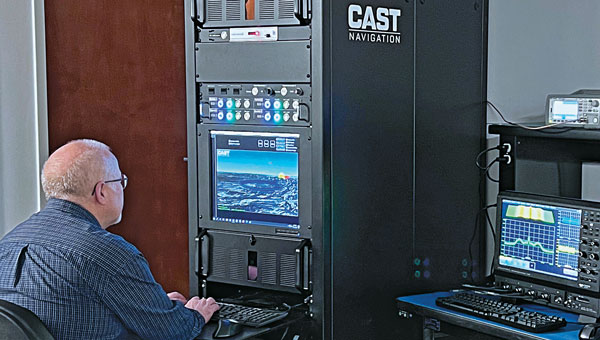
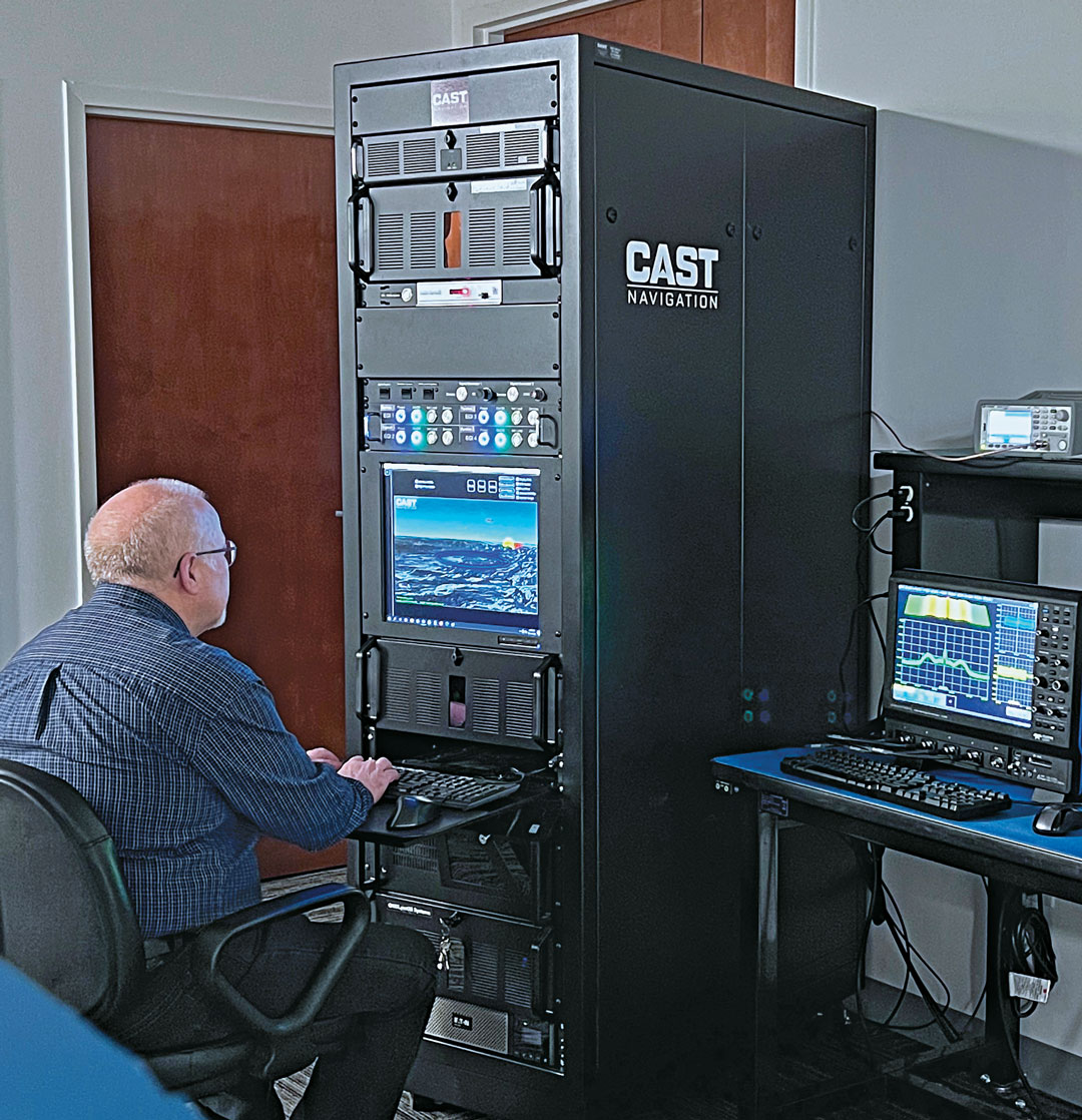
Senior Software Engineer Neil O’Brien utilizing a CAST-8000 GNSS Simulator to analyze CRPA trajectory data. (Photo: CAST Navigation)
Are simulator requirements changing?
Clark: In the past our customers were focused on the simulation of a single element of GNSS signals and a single INS output interface for the testing of vehicles that only supported single element antenna (FRPA) and a single INS capability. Our customers are now requiring simulator systems that produce multiple elements of phase-coherent GNSS signals that are commensurate with multiple INS interface outputs to drive navigation systems that can utilize a phased-array multiple-element antenna sub-system (CRPA) and multiple INS sources simultaneously.
Perdue: Yes, simulator requirements are always evolving. High signal counts are essential due to the increase in LEO constellations, and there’s a need to replicate multiple threats to create realistic environments. Built-in automation is crucial for managing these complex scenarios. The ability to add custom signals and constellations is necessary for experimenting with new technologies. Our software-defined architecture allows for quick integration of new signals, ensuring flexibility and responsiveness to changing needs. Innovations such as a radio utilizing the RFSoC to provide a high number of multi-frequency outputs from a single system and the BroadSim Duo, which offers dual-frequency capabilities in a compact form factor, demonstrate our approach to meeting these evolving requirements.
Ackermann: As new markets and use cases emerge, the simulator requirements evolve. The growing prevalence of NAVWAR threats, such as GNSS jamming and spoofing, and the range of systems these attacks are impacting is enhancing the criticality of lab testing.
Whether seeking to gain battlefield advantage or to secure civil operations (aviation, for instance), the ability to generate a wide range of NAVWAR attack vectors in complex scenarios is needed like never before. New waveforms must be incorporated quickly and realistically, while defensive technologies such as CRPAs must be exercised with a higher level of precision.
Crampton: Due to the demand for flexible attack vectors and the expanding range of available signals, simulators need to be capable of generating authentic RF environments from novel, user-defined waveforms. A time-saving method has been developed using prerecorded I/Q files. Spirent’s sixth-generation solution, PNT X, accepts raw I/Q data, analyzes the environment and the dynamic movement between receiver and transmitters, and automatically applies the correct motion effects to the generated RF signal. The simulated signal now has real-world dynamics without the need for manual inputs from the user. Realism made simple! Additionally, multiple I/Q-defined transmitters can be seamlessly integrated with native 3D terrain-modeling capabilities to create rich RF environments with multipath and obscuration.
A continuous, dynamic range is required to better replicate high-power jamming threats for controlled reception pattern antenna (CRPA) testing. With PNT X, high-power jammers can be simulated from the moment they become part of the noise floor to when a vehicle, such as an aircraft using a CRPA, passes by it. This continuous range enables CRPA developers to characterize null-steering ability with greater precision than previously possible.
Ackermann: As previously mentioned, there is also a growing need for integration and automation. Systems need to work in concert, and testing needs to happen quickly and efficiently to stay ahead of markets and threats. To this end, the ability to automate and to control remotely, and the ability to integrate seamlessly with other simulation and control systems, are core requirements for modern labs. Spirent is simplifying and automating testing with support for multiple industry-standard frameworks.
In established markets, safety requirements on devices under test drive simulator needs. For instance, functional safety requirements for automotive applications demand the ability to simulate threats and events, while the fidelity requirement of the simulation is elevated to assure conformance.
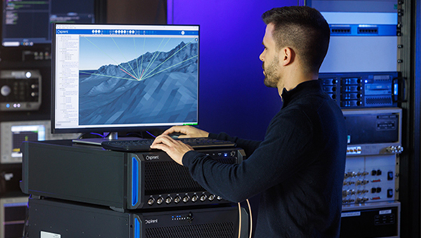
3D view of an aircraft flying a simulation. (Photo: CAST Navigation)
What mix of signals do you support?
Clark: GPS L1/L2/L5, L1C, L2C, C/A, SBAS, P, Y, SAASM, M-Code AES and MNSA, Glonass and BeiDou
Perdue: We support a wide array of signals, including GPS, GLONASS, Galileo, BeiDou, and regional systems such as QZSS and IRNSS. Additionally, we incorporate alternative navigation signals, such as those from Xona, and support inertial navigation and timing signals. Our software-defined architecture enables us to handle high signal counts and allows for extensive customization, ensuring we can simulate any required signal environment. This flexibility ensures we meet the diverse needs of various industries and applications, from aviation and maritime to autonomous vehicles and defense.
Ackermann:Spirent supports all open service GNSS signals and classified GPS testing — including M-Code Regional Military Protection — as well as PRS (through prs[ware] and our partnership with Fraunhofer IIS) on our simulation platforms.
In addition:
Regional systems (e.g., NavIC or QZSS)
S-band frequency signals
Custom non-ICD signals
LEO PNT (Xona Space System’s PULSAR and others)
A broad range of interference waveforms, including CW, FM, PM, wideband AWGN, chirp, matched spectrum, etc.
Generation of RF from I/Q data injection in L-band and S-band frequencies
Correction/augmentation
Inertial sensor emulation
Furthermore, the ability to geolocate custom RF beacons either in a range of orbits or in terrestrial locations adds huge signal flexibility.
What are the key challenges you face?
Clark: As our customers’ needs grow and evolve, some of our key challenges have been the ability to continue to evolve our product utilizing cutting-edge technology while still maintaining backwards compatibility with our older technologies. Efforts like this give our customers peace of mind when making a system purchase and enable them to take full advantage of prior purchases when requirements change and system enhancements are necessary.
Perdue: A key challenge is creating complex simulation environments that require specialized expertise. Customers often lack the knowledge to design these environments effectively. Ensuring simulation accuracy and cybersecurity are significant concerns, especially as new threats emerge alongside new technologies developed to combat existing threats. Translating performance requirements into practical specifications and meeting stringent industry standards adds another layer of complexity. We address these challenges through continuous updates and close collaboration with our customers to ensure our solutions meet their evolving needs.
Ackermann: For 40 years, we have faced a challenge that, to some degree, is being addressed. Namely, PNT is not widely standardized and therefore test requirements are highly diverse. The scale of Spirent and the empowering flexibility of our systems enables us to overcome this, but it remains challenging.
The current geopolitical situation also presents challenges, as the number of threats and the potential for negative events demand ever-increasing sophistication in testing. That’s why we built PNT X with high-power jamming and spoofing capability for greater realism and accurate test results.
Crampton: The complexity of next-gen positioning engines means that our systems have to integrate and interact with other systems, built by other companies with other protocols and specifications. Spirent maintains the precision and stability our customers expect from us while incorporating an open and controllable architecture for easier plug-and-play in complex hardware-in-the-loop environments.
M3 SYSTEMS
Please introduce your company.
Tsaturyan: We represent the Mistral Group, which includes three distinct companies: M3 Systems France, M3 Systems Belgium and Boreal. M3 Systems France teams provide GNSS simulation and test and measurements solutions and radionavigation and signal processing expertise. M3 Systems Belgium teams are experts in air traffic management (ATM) studies. Boreal teams offer beyond-line-of-sight missions for maritime surveillance, Earth observation, and scientific experiments with the BOREAL long-range unmanned aircraft. Each company extends its scope to the challenges of GNSS and UTM with an integrated approach.
What are your key markets? What challenges are you addressing?
Our customers are from different industries: we work with space agencies — such as France’s Centre National d’Études Spatiales (CNES) and the European Space Agency (ESA) — private R&D labs and automotive companies and railways. We propose GNSS simulation products such as the Stella GNSS simulator, which allows users to simulate a vehicle in a realistic environment and in real time for low latency. Our simulator is designed to reproduce the sky with high precision. The GNSS signal passes through different layers, each one of which has a different effect. First, there can be an error in the satellite clock, then there can be a delay as the signal passes through the atmosphere, then, on the ground, there is a risk of a spoofing or jamming attack and, in urban areas, multipath from buildings.
What signals does your simulator support?
Our GNSS simulator is multiconstellation and multi-frequency. It supports all the available GNSS signals and frequencies. Users can simulate multiple antennas and multiple trajectories, custom atmosphere and multipath effects. We offer several built-in models of multipath. Users also can use their own multipath models and even integrate it with an SE-NAV multipath simulation tool. We also have several built-in jamming signals that users can apply and spoof the real signal coming from the antenna or spoof the simulated signal. Our setup now also supports Galileo’s Open Service Navigation Message Authentication (OSNMA). Our Stella GNSS simulation software can run on three different products designed for specific needs: the Stella GNSS Simulator Base (based on NI’s USRP kit), the Stella GNSS Simulator Suite (based on our bundle), and the Stella GNSS Simulator Advanced (based on NI’s VST). Our VST-based solution is optimized for tests that require high performance in terms of calibration — such as simulating a CRPA antenna, where the channels need to be very tightly synchronized.
Photo: M3 Systems
What does your Stella Suite do?
The Stella GNSS Simulator offers up to two independent RF simulations, enabling simultaneous simulation and the jamming/spoofing or the simulation of multiple antennas and trajectories.
Our simulator suite is basically an all-in-one device that allows users to plug in a receiver. This single device enablesusers to simulate jamming, spoofing, multiple antennas or multiple trajectories.
When did you launch this product?
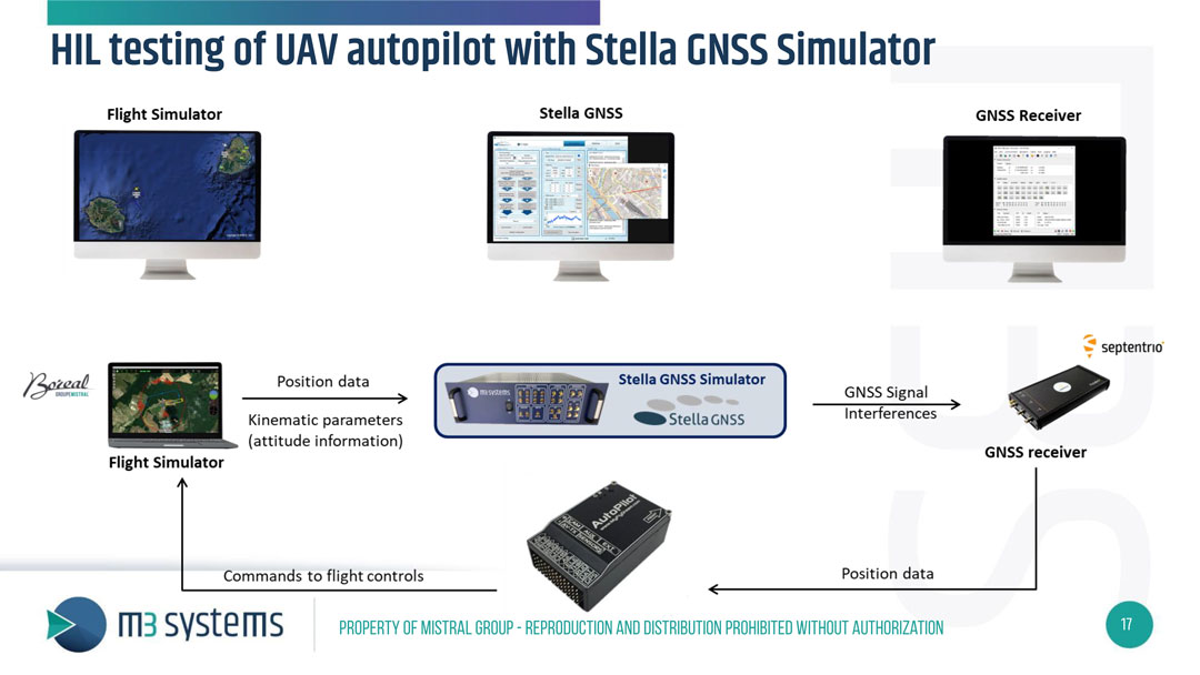
We released it and demonstrated it during Emerson NI’s “NI Connect” event. They have an annual event in May in Austin, to which they invite all their partners and customers. This year, we were invited there to present our new simulator. We brought a HIL test setup to demonstrate the new configuration of our GNSS simulator: a closed-loop test of a drone autopilot system. When kinematic parameters from the flight simulator are simulated, the trajectory is sent to the Stella GNSS simulator, which then generates the GNSS RF signal and interference to assess the receiver’s performance. The receiver then passes its positioning data to the autopilot, which sends the commands to the flight control unit in the flight simulator. It’s one of the use cases, because to fully test the receiver, in addition to the nominal situation, it is also necessary to introduce some errors — such as interference, jamming, spoofing or meaconing.
What are some other use cases for this simulator?
Another use case is the test of Advanced Driver Assistance Systems (ADAS) in a 3D simulation environment. Basically, it is designed to test any unit that includes the GNSS positioning and to test the receiver’s robustness in case of jamming, spoofing, or meaconing.
Is this all done in the lab or can you put your box in a vehicle?
With this setup, it’s all done in the lab, but we also offer solutions to record the real signals from a UAV or a ground vehicle.
Are the challenges changing? Is the market changing?
Now, a GNSS simulator is no longer sufficient. Testing the receiver’s robustness against various types of attacks, particularly jamming, requires diverse methods. Consequently, there is an emerging need for simulating jamming mitigation antennas, such as Controlled Reception Pattern Antennas (CRPA).
Anna Thorpe, marketing manager at Spirent Federal Systems showcases Spirent’s new PNT X simulator. This simulator is specifically designed for navigation warfare testing.
A Spirent user employs a portable GSS6450 attached to an antenna to record GPS, other GNSS, and complementary signals for resilient PNT testing. (Image: Spirent)
What is Spirent’s GPS origin story?
Spirent’s GPS genesis began on a rooftop in the middle of the night in the early 1980s. Engineers were attempting to acquire the new GPS signals with their receivers, scheduling their lives around the times when satellites would pass overhead, angling antennas off a roof in the dark, and hoping for favorable conditions. Those difficulties inspired an idea: since real-world conditions are never the same twice, simulating the signals in a lab would control variables and provide repeatable and trustworthy results.
That idea grew to be Spirent’s positioning division — a team of experts whose sole focus is to partner with customers to accelerate the deployment of robust PNT technology. In 1985, one of the first groundbreaking simulators provided to a customer generated six GPS L1/L2 signals. Soon after, we developed the world’s first simulator with SA-A/S capability, establishing our reputation for innovation. Today, simulation is for much more than convenience. The further upstream testing starts, the better for R&D and investment decisions. Because of that, we work across the spectrum in close partnership with constellation developers, receiver manufacturers, and OEM application integrators.
Can you share a recent breakthrough?
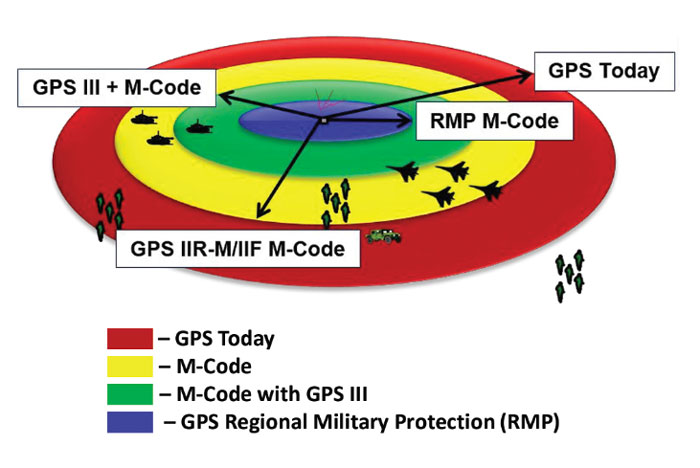
GPS regional military protection (RMP) is a nascent anti-jamming capability that uses a steerable, narrow-beam M-code signal, allowing U.S. and allied forces to operate much closer to interference without losing connection. Spirent supports RMP, so modernized GPS user equipment (MGUE) can be tested and integrated with RMP long before live-sky signals are available.
Another major breakthrough is in AltNav, a catch-all term that includes non-GNSS sources of RF and other complementary PNT, with recent attention focused on low-Earth orbit (LEO) constellations. Spirent has developed LEO AltNav simulators for both the military and commercial sectors that seamlessly integrate with Spirent’s extensive testbed for GNSS, threat simulation, inertial navigation systems, and additional complementary PNT.
How is your company preparing for the next 50 years of PNT with GPS and beyond?
As a trusted industry test partner, one of Spirent’s guiding principles over the past five decades has been to support PNT developers and early adopters by being first-to-market with new signals and constellations. Enabled by our flexible solutions, our dedication to that tenet will continue across the next five decades.
NAVWAR resilience testing is an area where emerging test needs will continue to demand more from the test environment. Layered PNT positioning engines — including GNSS, secure military signals, CRPA systems, multi-orbit architectures, and sensor fusion — are driving complexity in the test regimes that support them. Spirent’s purpose-built solutions are designed to meet these advancements, with deterministic simulation that delivers definitive validation and accurate test results.
Spirent pioneered the use of software-defined radios for GNSS simulation with the GSS9000, which enabled the same architecture to support new signal types, higher motion rates, user-defined waveforms, and more than double the generated signals. The next generation will extend that flexibility, capacity, and ease of integration to future complementary PNT sources while maintaining system performance across physical and virtual realms.
An exclusive interview with Mark Holbrow, VP of Product Development, Spirent Communications and Roger Hart, Sr. Director of Engineering, Spirent Federal Systems. For more exclusive interviews from this cover story, click here.
What are your roles?
MH: Our business is based in the UK. I am responsible for the vision and direction of the Technology portfolio required by Spirent’s Positioning Technology business unit.
RH: I am responsible for the U.S. add-on components to the simulator, the restricted signals, and support for the U.S. government labs and contractors.
How have the need for simulation or the requirements for it changed in the past five years, with the completion of the BeiDou and Galileo GNSS constellations, the rise in jamming and spoofing threats, the sharp increase in corrections services, and the advent of new LEO-based PNT services?
MH: I would say that the need for thorough and comprehensive testing has never been greater. That need is being driven on multiple fronts due to the understandable pressure on PNT systems needing to deliver enhanced accuracy, reliability and resilience, in the presence of emerging threat vectors and an expanding application space that’s utilizing ever more complex combinations of new and enhanced signals and sensors of opportunity. Underpinning Spirent’s leadership in ensuring the test needs for this evolving, challenging and increasingly diverse market are its team, its technology and its partners. That team is well-established, dedicated and highly experienced — their sole focus is designing, manufacturing and supporting PNT test solutions. The technology focuses around our pioneering dedicated SDR hardware platform and software simulation engine, which allied provide performance, scalability and flexibility, within an open accessible architecture. In addition, close collaboration with our selected partners ensures the opportunity to support and integrate new and emerging PNT technologies through their tools, applications and hardware.
You mention the advent of LEO. A key reason why Spirent was first to market and successfully supported an early LEO + GNSS receiver test-bed (through close and collaboration with Xona and NovAtel) was driven by team, technology and partners.
Two other important areas that have definitely continued to grow and evolve in importance and priority have to be increased realism and test automation. Both are areas in which Spirent continues to prioritize and invest R&D dollars.
Spirent’s integrated, software-defined wavefront simulation system for a 5-element controlled reception pattern antenna (CRPA). Spirent solutions support 16+ antenna elements. (Image: Spirent)
With all these additional signals, is it still a single simulator or do you have to somehow split it up into different modules?
MH: Good point. Again, a key element with the Spirent solution is that it is very scaleabale and flexible. Spirent has a generic SDR that can be re-purposed to simulate whatever signals are required. That way, we can compile different signals from either one radio or multiple radios coming from the same system. Together with being able to bring in multiple chassis to gradually grow the simulation solution, while also maintaining for each of those signals the fidelity, channel count, and accuracy that customers demand.
Including every signal currently available?
MH: Absolutely, sir. In fact, signals that are still on the drawing board as well. We can enable the user with effectively an arbitrary waveform simulator or ‘sandbox’ to experiment with different modulation schemes, different chipping rates, codes, bandwidths and navigation data content. So, in addition to using that architecture to generate the signals, we allow customers to experiment with it themselves. That’s certainly accelerated over these last five years, and there’s no sign of it stopping. We’re currently working with customers and partners all over the globe who are developing both brand new and emerging PNT systems, whilst also providing all the vital simulation tools to aid the R&D of existing and planned SIS evolutions.
RH: The increasing number of signals that we can support multiplies the permutations and combinations of test cases that users can do. There is a lot of emphasis also on the user interface side of things, so that from one interface you can also easily control all these interfaces with third-party tools, because proliferation of signals produces a huge possible test volume.
What are the specific challenges in realistically simulating new LEO-based signals and any new services being developed for which you don’t have any live sky signals to record yet, only ICDs and other documents?
MH: Again, great question. The key reason Spirent excels in this arena is that the core simulation engine and SDR are agnostic of the constellation and signal type that’s being generated. So, the underlying principles of accuracy, range rate, pseudo-range control, and delay, together with the RF fidelity from Spirent’s SDR+ Sim engine, can be readily manipulated to simulate the wealth of emerging signals, including LEO.
The other area that becomes very important is that if we do not have sight of the ICD, we can enable customers to use our tools to readily populate elements of that ICD themselves. That way, the best of both worlds is achieved, i.e. a turnkey SIS solution, or we can just enable the customer to do it themselves.
Are accuracy requirements or any other requirements for simulation increasing to enable emerging applications?
MH: They are. Both current and emerging test needs are continuing to drive the need for enhanced simulation realism. Always a tough nut to crack, but our hard-won experience and expertise, allied with continuing adoption of latest-generation technology, is allowing us to take some significant strides forward. Real-world testing has an incredibly important role to play and that’s why at Spirent we continue to invest in and develop the GSS6450 Record & Playback System (RPS). However, we are also on that quest for the ‘Holy Grail’ that has all the well understood and necessary advantages of lab-based testing but with the simulation environment being as true to the real world as possible.
A German Armed Forces test center, WTD-61, recently used Spirent’s new Field Simulator to conclusively demonstrate the susceptibility of some UAS to spoofing. (Image: Spirent)
A further area where both current and emerging test needs are demanding more and more from the test environment is resilience testing. Spirent now supports a multitude of vulnerability and corresponding mitigation/prevention test cases. Those test cases become increasingly complex as multiple combinations of the threat/mitigation surface evolve — including jamming, spoofing, cyber-attack and CRPA.
Many of these test cases are driving the state of the art and, especially in the case of CRPA testing, Spirent’s purpose-designed SDR comes into its own. Technology bakeoffs and corresponding customer adoption have shown that only through the use of that dedicated purpose-built technology, the simulator test bed can deliver the necessary carrier and code phase stability, very low levels of uncorrelated noise across antenna elements and high J/S that is demanded.
Again, with respect to flexibility, we also support ways to let customers generate their own IQ data. That data can be streamed into the Spirent simulator and combined sympathetically and coherently with the signals generated inside the platform. So, you can layer new signals on existing ones, or introduce a completely new dedicated IQ stream.Finally, hardware-in-the -loop (HIL) testing requirements continue to be a crucial aspect in test coverage. Whether that application is automotive, projectiles or autonomous vehicles, the need for lower latency and higher 6DOF sampling to capture as many trajectory nuances as possible continues to grow. Spirent’s 2KHz system achieves very high iteration rates (SIR) and <2msec latency.
What are the key differences between your simulators for use in the lab and those for use in the field? I assume that the latter are lighter, smaller, and less power hungry. Do they use modules so that users can pick the ones they need for a particular test?
MH: We do support in-the-field test use cases. Spirent has record-and-replay (RPS) systems to take soundings in a wide-band RF environment, record them, then bring them back into the lab for replay. They are sized to fit into a backpack, battery-powered, accessible, and easy to use.
Recently, we have also taken some of our signal generator IP and been able to create a smaller form factor portable simulator for outside use. Its footprint is considerably smaller than that of one of our lab-based simulators. It’s primarily a mechanism for testing the resilience in the field of devices under test. Armed with a Spirent simulator and the appropriate transmit licenses, a customer can put their DUT through an array of vulnerability test cases in a live real-world environment.
You mentioned licenses. As far as jamming, specifically, and maybe spoofing, I presume that you’ll need a license for a specific time and place and that you will have to be far away from, say, an airport.
Absolutely. Right. The details will vary depending on the jurisdiction, but you will need a license to transmit. And, as you rightly say, often those places will be very remote so as not to interfere with the public. We’ve had instances where we’ll work with a customer who has those appropriate licenses and then we can provide this equipment for them to be able to put it through a battery of tests.
You generate the spoofing in your simulator, of course. Do you also generate the jamming inside the same box or from a separate jammer nearby?
It could be either. We can use our simulators to generate internally wide range of interference signals supporting a wide bandwidth, high max o/p power and large dynamic range. This is especially important in instances of CRPA testing, in which it is vital to accurately reproducing a jamming wavefront commensurate with the arrival angle and delay incident at each antenna element. Correspondingly, we support turn-key solutions to connect, control and integrate 3rd party external signal generators into the test scenario.
Are you at liberty to describe any recent success stories?
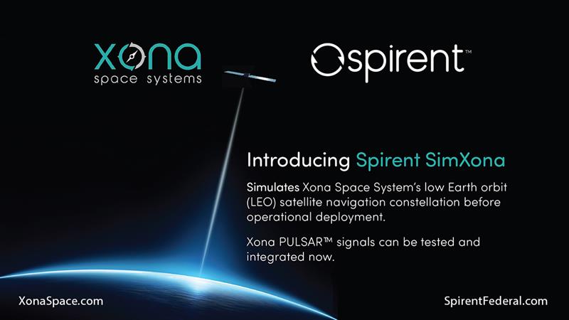
We have a Xona simulator. So, this is back on the topic of LEO. We’ve recently released that in partnership with Xona. We are also working closely with Hexagon. All those things I mentioned earlier about enabling the customer to use the flexible features that we have, that is where it came into its own. That’s certainly a significant recent success.
We’re continuing to add many realism-related capabilities, including simulating the vibration and temperature effects of inertial systems. Working with a Swiss partner called Space PNT, we’ve recently introduced another LEO-based product, called SimORBIT. That tool enables us to generate incredibly representative and accurate LEO orbits that also include gravitational effects based upon the SV size. We recently introduced a new software tool to support “GNSS Assurance” requirements.
We have a newly patented cloud-based software application called GNSS Foresight that enables users to understand the GNSS coverage they would expect during a particular time, date location and trajectory inclusive of the 3D environment they would be experiencing. We continue to evolve the tool to support real-time operation to enable it to deliver aiding content to appropriately equipped systems.
We continue to be able to support more and more automation. Automation has always been important, but with ever increasing demands of test asset utilization and in a post-pandemic world of remote working, it’s more important than ever right now. The number of test cases and corner cases required and the amount of equipment, coverage, and efficiency required, which was being demanded by using our kit means that automation is vital. So, we’ve introduced several new automation tools to build up on top of our current SimREMOTE interface.
Spirent has also developed a simulation test solution for the Galileo Open Service Navigation Message Authentication (OSNMA) mechanism. SimOSNMA is designed to work with Spirent’s GNSS simulation platforms to test OSNMA signal conformance, which will bring new levels of robustness for both civilian and commercial GNSS uses. SimOSNMA provides developers with vital new simulation tools to test for OSNMA, the security protocol that enables GNSS receivers to verify the authenticity of signals distributed from the Galileo satellite constellation. Designed to combat spoofing, OSNMA ensures that the data received is authentic and has not been modified in any way. It is currently completing the test phase before its formal launch, and SimOSNMA enables developers to simulate and test OSNMA signals and features, allowing GNSS receiver manufacturers and application developers to accelerate and assure development programs.
Spirent’s GSS6450 record and playback system (RPS) used to record live-sky signals in an urban environment for testing in the lab.(Image: Spirent Federal Systems)
These are interesting and challenging times for the makers of GNSS signal simulators.
For decades, developers and manufacturers of GNSS receivers have needed to simulate the satellites’ signals to test receivers in their labs and in the field. Meanwhile, users of GNSS receivers for critical missions — such as military operations and rocket launches — have needed to simulate the exact conditions (the number of satellites in line of sight, the positional dilution of precision, etc.) at specific points in time and space.
As the number of constellations, satellites and signals grew — especially in the past few years, with the completion of the BeiDou and Galileo constellations — simulator manufacturers were challenged to keep up. Threats of jamming and spoofing also increased. Then, a few companies began to develop new positioning, navigation and timing (PNT) constellations in low-Earth orbit (LEO). Now, it is common for simulators to require several hundred channels.
I discussed these challenges and the prospect for the simulation industry with representatives of five companies:
Tim Erbes, Technical Director, Safran Federal Systems (formerly Orolia Defense & Security
For the full transcripts of my interviews, click here. If you like this article, you will love the interview transcripts, which cover much more than I had room for here.
Legacy Constellations and New Ones
Simulator manufacturers cite a variety of challenges. According to Erbes, a big one is determining users’ requirements. “Often,” he said, “they can’t determine what the specs need to be. All they know is that they need it to work.” This is particularly true when mixing and matching receivers, IMUs, and components from different manufacturers, he pointed out.
For decades, there were only two GNSS constellations (GPS and GLONASS). A couple of years ago, two more came online (BeiDou and Galileo). Meanwhile, several regional augmentation systems were developed (SBAS, EGNOS, NavIC, QZSS and KASS), some of which may later grow into global systems. Now, new LEO-based systems are being developed. For simulator manufacturers, what was once clear “began to get fuzzy,” Erbes said. “If you ask members of our team right now how many constellations we support, you will not get a quick answer. We’re trying to be forward-looking and add everything that might be up there so lab users can develop and test.”
Multi-constellation simulation is a particularly challenging problem for groups that don’t have simulators, Erbes pointed out. “We have the advantage of having a software-defined architecture. We designed the software so that it is easy to add new constellations to it. Basically, once we’re given a proper interface control document (ICD), we’re only a couple of months away from a first draft implementation of that new signal. Then we iterate.”
In the past few years, said Thomas, Racelogic “had to suddenly invent 15 new signals.” It makes a record-and-replay system — “You put a box in a car, on a bike, in a backpack, or on a rocket, and you record the raw GPS signals,” Thomas said — and another system in which it simulates the satellites’ signals “from pure principles.” The latter, he noted, has been “15 times the original work we thought it would be. However, as we add each signal it tends to get a bit simpler until they add new ways to encode signals, and then it gets complex again.”
Spirent Communications’ technology, Holbrow said, focuses around “its dedicated SDR hardware platform and software simulation engine, which provide performance, scalability and flexibility, within an open accessible architecture. Close collaboration with our selected partners ensures the opportunity to support and integrate new and emerging PNT technologies through their tools, applications and hardware.” Two other aspects that have continued to grow in importance have been “increased realism and test automation,” Holbrow said. “Both are areas in which Spirent continues to prioritize and invest R&D dollars.”
Spirent “can enable the user with effectively an arbitrary waveform simulator or ‘sandbox’ to experiment with different modulation schemes, different chipping rates, codes, bandwidths and navigation data content,” Holbrow said. “The increasing number of signals that we can support multiplies the permutations and combinations of test cases that users can do,” Hart added.
Not every simulator user is equally interested in simulating all the existing and emerging constellations. Those in the U.S. military market do not use foreign signals, pointed out Clark. However, they may want to understand how those signals could impact their vehicle, platform, or individual receiver.
LEO-based constellations “have become a buzzword in the last year or so,” Clark said. Because CAST Navigation’s simulators are modular and use an FPGA-based design, “we can add different satellite constellations or satellite protocols to our system,” he said. “However, we don’t offer anything commercially yet due to a lack of an official ICD, or any kind of documentation that defines any of these new LEO-based signals.”
Today, said Pielmeier, all high-end RF simulators must support “all existing GNSS systems with all related signal components on all frequencies.” Additionally, to remain competitive, they must be kept “up-to-date with the new and continuously evolving GNSS signals.” He added: “Beyond the L-band signals, we are also fully supporting the S-band signals of the NavIC constellation.”
The increased request for precise point positioning (PPP) corrections service, Pielmeier pointed out, was the driver for IFEN to add the High Accuracy Service (HAS) PPP-correction capability on Galileo’s E6-B signal to its next release. “We expect further improvements here during the next few years, especially to cover the emerging needs of the PPP-RTK market.” The advent of LEO-based PNT services, he said, makes this “the most important driver for the next five years, extending the signal frequencies beyond the current L- and S-band signals, seeing new modulations, two-way transfer and many more topics.”
Jamming and Spoofing
Concern about jamming and spoofing has increased significantly over the past several years. These, however, are not new concepts for simulator manufacturers. “In a way, simulation is ahead of this state of the world,” said Erbes. “Spoofing is similar to simulation. So, we already know how to do that.” That could change, however. “If new requirements come up, such as higher data rates or wider bandwidth waveforms or different types of waveforms, then we would have to adapt and add support for that kind of stuff.”
“Because our systems record and replay, they’re used a lot to record real-world jamming,” said Thomas. Regarding spoofing, Racelogic has just improved its signal simulation. “We can do seamless takeover of a GNSS signal in real time. We can reproduce the current ephemeris and almanac. If we transmit a sufficiently powerful signal, we can completely take over that device.”
Over the past five years, most of CAST Navigation’s customers have become much more interested in being able to simulate jamming and spoofing, Clark said. “If you’re doing anything of any importance in a contested environment, you’re going to come up against some type of spoofing and/or jamming interference.”
Pielmeier agreed that simulation of jamming and spoofing threats has been a major market driver in recent years. “Our latest RF simulator generation, NCS NOVA+,” he said, “fully supports all types of jamming and spoofing and is fully integrated into our RF simulators to enable coherent signal generation. With the coming safety-of-life and automated driving applications based on DFMC (SBAS/GBAS dual-frequency multi-constellation), the need to support advanced jamming and spoofing simulation solutions will remain a continuous driver.”
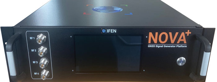
IFEN’s rf signal generator technology, based on a modular and highly flexible Software Defined Radio (SDR) platform. (Image: IFEN)
Simulating What Does Not Yet Exist
The current GNSS constellations broadcast signals that can be recorded, played back, and used to generate accurate simulations. For systems still being developed, however, simulator manufacturers must rely on each system’s ICD, if and when it is available. Even for established systems, the live sky signals may diverge from the ICD. “Is the simulator supposed to match live sky,” Erbes wondered, “or is it supposed to match the intended final state of the constellation, according to the ICD? This is a huge topic for M-code, which is ever changing, and has a very large ICD that is released incrementally. We’re constantly having to make changes to the simulator to match those releases.”
A big challenge for simulator manufacturers is to keep pace with new and evolving ICDs. “There are more constellations than ever, and the technology makes it easier to change signal architectures,” said Erbes. “We’re going to start talking about signals that can be reprogrammed on the fly. That’s going to make simulation more and more challenging.”
Simulating signals for new systems that are not yet deployed is a matter of “pure signals simulation,” said Thomas. “You go through the ICD line-by-line and work out the new schemes. You are very much reliant on every single word in that ICD.”
New LEO-based systems are not the only ones to present this challenge to simulator manufacturers. “L1C is another one of those problem child signals that we have developed,” said Clark. “All we can do is buy all the makes and models of L1C receivers available for sale and utilize our simulator, along with those receivers, to see whether things are good. We’ve asked the government for an L1C code sample, but it will not be available until the satellite manufacturers launch the satellites in their final configuration. Until then, we’ll develop to the ICD that’s been released and defined, then cross our fingers.”
Spirent’s core simulation engine and SDR “are agnostic of the constellation and signal type that’s being generated,” Holbrow said. “So, the underlying principles of accuracy, range rate, pseudo-range control, and delay, together with the RF fidelity from Spirent’s SDR+ Sim engine, can be readily manipulated to simulate the wealth of emerging signals, including LEO.” Additionally, when an ICD is not available, the company can enable its customers to use its tools “to readily populate elements of that ICD themselves.”
In the Lab vs. In the Field
“All our systems can be carried in a backpack, on a push bike, in a car,” said Thomas. “We do that deliberately, because we come from the automotive side of things, so we have to keep everything very small and compact. Some of our customers have put them in rockets, recording the signal as it goes up, or in boats. We have people walking around with an antenna on their wrist connected to one of our systems, so that they can simulate smartwatches.”
CAST Navigation has simulator packages that range “anywhere from shoebox size to nine-foot-tall racks,” said Clark. “They are all modular, so you can add options and capabilities over time. We have simulators that are used in the field. Some of the testing groups with the U.S. armed forces have used our simulators in the back of a Humvee along with other proprietary equipment to conduct their own field experiments.”
Spirent supports in-the-field use cases: its portable simulator can test PNT resilience while the DUT is receiving live-sky signals, and their record-and-playback system takes real-world soundings in a wideband RF environment for playback in the lab.
Currently, Pielmeier said, all IFEN simulators are designed for lab use. However, “we recognize an increased request for field-capable RF simulators, specifically to perform spoofing of real SIS to test deployed GNSS receivers in the field. Offering a portable in-field solution is in our mid-term planning, but not a current driver for our developments.”
Testing vs. Mission Planning
How do simulators used by receiver manufacturers in their labs and in the field to tweak existing receivers or develop new ones differ from those used for mission planning? “In most lab simulations, they can just run with a default constellation for a given day,” Erbes explained. “They’ll run that scenario hundreds or thousands of times and never need to change it because they’re testing parts of the receiver that don’t care a whole lot about the specifics of what’s happening.”
Missions, by contrast, are time- and location-specific. Planners need to know which satellites will be overhead at an exact time and place. “When you’re doing real day mission planning, the big problem isn’t so much how to generate a signal, it’s how to find out what’s happening today.”
Increasing Accuracy Requirements
Like those for receivers, accuracy requirements for simulators are increasing to match those of emerging applications. “Everyone’s chasing the goal of getting smaller, faster, and more accurate systems,” said Thomas. “We do real-time simulators, and they want a smaller and smaller delay from when you input the trajectory to when you get the output. Luckily, we’re able to keep up on the hardware side as well, because much of our processing is done using software.”
As accuracy requirements rise, “Real-world testing has an incredibly important role to play,” said Holbrow. Additionally, as resilience testing places increasing demands on test equipment, Spirent Communications now supports “a multitude of vulnerability and corresponding mitigation/prevention test cases” to deal with jamming, spoofing, cyber-attack and CRPA
CAST Navigation’s simulators meet or exceed accuracy requirements, Clark said. “We have pseudo-range accuracy down to a millimeter, our phase coherence doesn’t wander, and we’re able to achieve 2.5 ps to 3 ps synchronization coherence during multi-element, phased-array antenna simulations. We see our customers interested in a higher performing simulator, and that is our commitment.”
Pielmeier had a different perspective on this: “We saw no increase in the required accuracy, as the typical requested accuracies are far beyond the real accuracy of the signals anyway.”
Recent Success Stories
Racelogic has developed a system to replace or augment GPS in tunnels, which often pass over each other or match the routes of surface streets. “We’ve been talking to many cities around the world that are building new tunnels,” said Thomas. “It requires installing repeaters every 30 meters along each tunnel and software that runs on a server and seamlessly updates your position every 30 meters.”
Clark pointed out that CAST Navigation’s “bread-and-butter” for the past few years has been “larger systems that can drive phased array antennas, along with inertial units, and full high-dynamic aircraft, in real-time environments.” He added that “the smaller systems, which used to be popular, have mostly gone by the wayside.”
As a recent success, Holbrow cited Spirent Communications’ release of a Xona simulator, in partnership with Xona Space Systems, as well as the addition of “many realism-related capabilities, including simulating the vibration and temperature effects of inertial systems;” a cloud-based software application called Foresight that enables users to understand the GNSS coverage they would expect at a particular time, location and trajectory based upon accurate 3D scenes; and a simulation test solution for the Galileo Open Service Navigation Message Authentication (OSNMA) mechanism. Finally, he stressed Spirent’s increasing support for automation.
Pielmeier cited the Galileo second generation Test User Receiver contract that IFEN received from the European Space Agency as its most important recent success. “Within this contract, the NCS NOVA+ simulator as RF test tool will be upgraded to full G2G signal generation capability. The new already implemented G2G signals enable shorter time to first fix (TTFF) and improved acquisition performance but also higher updates rates (e.g., for PPP-RTK). Through the end of the year, the G2G signal will be fully implemented in our RF simulator, including the next generation of advanced authentication solutions.”
Advanced industrial societies are increasingly reliant on the fantastic capabilities of global navigation satellite systems (GNSS) — GPS, GLONASS, BeiDou and Galileo — and, therefore, increasingly vulnerable to their weaknesses. From providing our position on a map on our smartphone to timing financial transactions, cell phone base stations, and the internet; from steering tractors in the field to guiding first responders; from giving surveyors sub-centimeter accuracy to monitoring continental drift; from providing navigation to ship captains and airplane pilots, to enabling automated control of earth moving machinery, GNSS have become a critical infrastructure. Yet their well-known vulnerabilities — such as jamming, spoofing, multipath and occultation — continue to fuel the development of complementary sources of positioning, navigation and timing (PNT) data, especially for new and rapidly expanding user segments such as autonomous vehicles.
In a January 2021 report, the U.S. Department of Transportation pointed out that “suitable and mature technologies are available to owners and operators of critical infrastructure to access complementary PNT services as a backup to GPS.”1
Several new PNT systems are being developed and deployed that are partially or entirely independent of the four existing GNSS constellations. This cover story focuses on the following companies, products and services:
Safran Federal Systems (formerly Orolia Defense & Security) makes the VersaPNT, which fuses every available PNT source — including GNSS, inertial, and vision-based sensors and odometry. I spoke with Garrett Payne, Navigation Engineer.
Xona Space Systems is developing a PNT constellation consisting of 300 low-Earth orbit (LEO) satellites. It expects its service, called PULSAR, to provide all the services that legacy GNSS provide and more. I spoke with Jaime Jaramillo, Director of Commercial Services.
Spirent Federal Systems and Spirent Communications are helping Xona develop its system by providing simulation and testing. I spoke to Paul Crampton, Senior Solutions Architect, Spirent Federal Systems as well as Jan Ackermann, Director, Product Line Management and Adam Price, Vice President – PNT Simulation at Spirent Communications.
Satelles has developed Satellite Time and Location (STL), a PNT system that piggybacks on the Iridium low-Earth orbit (LEO) satellites. It can be used as a standalone solution where GNSS signals will not reach, such as indoors, or are otherwise unavailable. I spoke with Dr. Michael O’Connor, CEO.
Locata has developed an alternative PNT (A-PNT) system that is completely independent from GNSS and is based on a network of local ground‐based transmitters called LocataLites. I spoke with Nunzio Gambale, founder, chairman, and CEO.
Due to the limited space available in print, this article only uses a small portion of these interviews. For full transcripts of them (totaling more than 10,000 words) click here.
1 Andrew Hansen et al., Complementary PNT and GPS Backup Technologies Demonstration Report, prepared for the Office of the Assistant Secretary for Research and Technology, Department of Transportation, January 2021, p. 195.
Locata dish antenna pointed to the European Union’s Joint Research Center in Ispra, Italy, 44 km away, just under the setting sun. The Yagi antenna above is pointed to a cell tower in Como and used to connect the system for remote control and data logging. (Image: Locata)
Complementary PNT
“Traditionally, augmentation to GNSS has been done through inertial navigation systems (INS),” Price said. “More recently, ground- and space-based augmentation systems have increased in usage. However, both technologies depend on the absolute positioning information provided by GNSS. They do not represent a true alternative PNT.”
To facilitate the development of advanced and autonomous applications, Price suggested incorporating terrestrial sources of PNT as well as ones based on LEO, medium-Earth orbit (MEO) and geostationary equatorial orbit (GEO) satellites. This, he added, would also keep costs from becoming prohibitive. “LEO brings many benefits in comparison to MEO in just about every industry to which it can be applied,” Jaramillo said.
While mass reliance on GNSS facilitates access to GNSS data and makes devices that use it increasingly cost-effective, over-reliance on a single sensor is risky, Austin pointed out.
“That’s where complementary PNT comes in: if you can put your eggs in other baskets, so you have that resilience or redundancy, then you can continue your operation — be it survey, automotive or industrial — even if GNSS falls or is intermittently unavailable or unavailable for a long time,” Austin said.
It has been said that “the only replacement for GNSS is another GNSS.” Inertial navigation, dead reckoning, lidar, and referencing local infrastructure that, in turn, has been globally referenced using GNSS, enable mobile platforms to maintain relative positioning during GNSS outages. However, absolute positioning will continue to require GNSS. “If you claim to be breaking free from GNSS you’re really saying, ‘I can navigate in this building, but I don’t know where this building is,’” Austin said.
GNSS-INS Integration
GNSS and INS have always been natural allies because they complement each other. The recent completion of the BeiDou and Galileo constellations, which has greatly increased the number of satellites in view, has made the requirement for six satellites at any one time for real-time kinematic (RTK) “a much more reasonable proposition,” Austin said. Coupled with the drop in the price of inertial measurement units (IMU), this has made it possible to “make a more cost-effective IMU than ever or spend the same and get a much better sensor than you ever could before,” he said. “Your period between the GNSS updates is also less noisy and you have less random walk and more stability.”
It used to be that the performance of an accelerometer might far outweigh that of a gyroscope, resulting in excellent velocity but poor heading. “Now,” Austin said, “we can pick a much more complementary combination of sensors and manufacture and calibrate an IMU ourselves while using off-the-shelf gyroscopes and accelerometers. That allows us to make an IMU that is effectively not bottlenecked in any one major area.”
Autonomous vehicles require decimeter accuracy to keep to their lane, while their absolute position is irrelevant to that task. It is, however, essential for map navigation and to know about infrastructure such as traffic signs and stoplights that may not be in a vehicle’s line of sight.
“That’s where the global georeferencing comes in and where GNSS remains critical,” Austin said. “One of the key things we’re examining is GNSS-denied navigation: how we can improve our inertial navigation system via other aiding sources and what other aiding sensors can complement the IMU or inertial measurement unit to give you good navigation in all environments. Use GNSS when it’s good, don’t rely on it when it’s bad or completely absent.”
Nowadays, car makers are increasingly moving their research and development tests from indoor, controlled environments to open roads. Therefore, “they are looking for a technology that allows them to keep doing those tests that they did on the proving ground, but in real world scenarios,” Austin said. “So, they rely on the INS data to be accurate all the time. In autonomy and survey, on the other hand, the INS is used actively to feed another sensor to either georeference or, in the case of autonomy, actively navigate the vehicle. So, that data being accurate is critical because an autonomous vehicle without accurate navigation cannot move effectively and would have to revert to manual operation.”
Image: Xona Space Systems
New vs. Old
Complementary PNT systems differ from legacy GNSS along several variables. One is coverage. For example, Satelles and Xona will provide global coverage, while Versa PNT and Locata are local. Another is encryption. Unlike GPS, which encrypts only its military SAASM/M-code signal, Xona’s PULSAR system will encrypt all its signals, Jaramillo said. “For autonomous applications, security is very important. If you’re riding in an autonomous car, you certainly don’t want somebody to be able to spoof the GNSS signal and veer it off course.”
Additionally, the design of Xona’s constellation includes a combination of polar and inclined orbits, which will greatly improve coverage in the polar regions compared to current GNSS coverage. This is particularly important as climate change makes the arctic more accessible. “The idea of having a LEO-based constellation is to take advantage of what can be done in LEO for GNSS,” Jaramillo said. “If you want the most resilient time and position, you need to use a combination of everything.”
Based on its architecture, Jaramillo said, Xona will provide better timing accuracy than GNSS does today. “Our satellites are designed to use GPS and Galileo signals, as well as inputs from ground stations, for timing reference and will share their time amongst themselves. We will average all these timing inputs and build a clock ensemble on the satellites. That enables much higher accuracies than just having a few single inputs.”
Satelles’ STL service can either substitute for GNSS where the latter is unavailable or supplement it where it is available. When used as a supplement, “the goal is having a solution that is resilient to an outage, interference, jamming, spoofing, those sorts of things,” O’Connor said. “In that case, the receiver card that might be provided by one of our partner companies would have both GNSS and STL capabilities and would take the best of both worlds.” Depending on the product configuration, its locational accuracy is generally in the 10- to 20-meter range, O’Connor said.
Orolia Defense & Security’s Versa PNT “is an all-in-one PNT solution that provides positioning, navigation, and very accurate timing,” Payne said. “Every type of sensor that you’re using for PNT has its strengths and weaknesses. That’s why we have a very accurate navigation filter solution that dynamically evaluates the sensor inputs.” In GNSS-degraded environments, the Versa’s software alerts users that GNSS signals are not reliable, automatically filters out those measurements, and navigates on the basis of the other sensors, such as an IMU, a speedometer, an odometer, or a camera.
Locata’s system is completely independent of GNSS because it does not require atomic clocks. At its heart is the company’s TimeLoc technology, which generates network synchronization of less than a nanosecond, Gambale said. “TimeLoc,” Locata literature states, “synchronizes the co-located signals with other LocataLites as the signals are slewed until the single difference range between it and the other LocataLites is the geometric range. This internal correction process is accurate to millimeter level.” Applications of this system include indoor positioning for consumer devices such as mobile phones, industrial machine automation for warehousing and logistics, positioning first responders within buildings, and military applications in GPS-jammed environments.
Constellations and Timelines
How long will it take to develop and/or complete these complementary PNT systems?
Xona is a start-up, and its timeline will depend on its success with investors.“We have basically locked down our signal and system architecture. Now, it’s a matter of building out the ground segment and launching satellites,” Jaramillo said.
Xona’s current target is to launch its first satellites into operation by the beginning of 2025 and to achieve full operational capability by 2027. The company will roll out PULSAR in phases. “In our first phase, we’re going to offer timing services and GNSS augmentation that only require one satellite in view,” Jaramillo said. “Then, as we roll out to phase two, we’ll be able to start to offer positioning services in mid-latitudes with multiple satellites in view. Phase three will include high-performance PNT and enhancements globally.”
Satelles’ STL is already on Iridium’s 66 active satellites, which are all relatively new, having been launched between 2016 and 2018, and cover the entire globe constantly. STL’s signal and capability are flexible, O’Connor said.
Orolia Defense & Security is now evaluating UWB computer technology from different vendors and integrating it in the Versa’s software. “We will probably begin performing full field tests in the first quarter of 2024,” Payne said.
Locata’s mission, Gambale said, “is to deliver technology advances which enable complete, independent sovereign control over PNT for companies, critical infrastructure systems, and in the future – entire nations. It’s designed for the many entities and nations which do not have – and can never afford – their own constellations”.
“Our business model,” Gambale added, “is based on enabling others – from companies through to nations – to develop their systems and products based upon our core technology developments. We do not dictate how our technology will be deployed. Locata’s technology can be available to any suitably qualified partner, to fashion our core developments for their own use.”
The Launch of a Falcon 9 rocket carrying Xona satellites. (Image: Xona Space Systems)
Business Model
It is challenging for any new commercial entrant in the PNT field to challenge a free global service, such as GPS. While all these new services are the opposite of GPS, which is a gift from U.S. taxpayers to the world, their business models vary somewhat.
“We are targeting both mass market applications and high-performance ones,” Jaramillo said. “For the mass market applications, our business model includes a lifetime fee: a customer pays a fee one time, and the service works for the life of the device. For higher performance applications that have more capabilities associated with them, there will be different tiers, each with different services.”
These will include an integrity service that will verify that the signal has a certain level of performance thresholds, for use in critical applications. “If it drops below certain performance thresholds,” Jaramillo said, “we will flag that to the device so that it knows that, even though it is receiving a signal, it should not continue to use it due to signal degradation.”
Receivers and Chipsets
Predictably, these new ventures have spawned a web of alliances.
The success of both Xona and Satelles will hinge in part on the availability of receivers for their signals. To manufacture them, Xona is “in discussions with just about every tier one manufacturer out there,” Jaramillo said. “We have a strong relationship with Hexagon | NovAtel. They have been supportive of us for a long time now and are very advanced in their development and support for our signals.” Additionally, Xona designed its signals “so that most receivers can support them with just a firmware upgrade.”
Satelles is also working with partners, including Adtran (through their Oscilloquartz product line), Jackson Labs (now VIAVI Solutions), and Orolia (now Safran Trusted 4D). “Companies like that provide the solutions that are favored by critical infrastructure providers today,” O’Connor said. “They ultimately integrate our STL capability into their solutions. They can use our reference designs or create their own custom designs based on our reference designs.”
Satelles uses a different process to take measurements of the STL satellite signals than legacy GNSS. “It’s not a single chip that’s measuring both satellites, it’s ultimately two chips that are making those measurements,” O’Connor explained. “Then, we leave it to our partners to determine how to perform the position calculation and the integration of those signals. It can be integrated loosely or tightly.”
Markets and Applications
The target markets and applications for these new PNT services also vary.
The markets in which Satelles has the highest adoption rates are data centers, stock exchanges and 5G networks, said O’Connor. He pointed out that 5G networks need about five to 10 times more nodes to cover a geographic area than 4G networks.
“GNSS has been used for years to time 4G networks, but most 5G network sites — such as femtocells and picocells — are indoors or in places where GNSS is challenged. We deliver that timing service indoors, outdoors, everywhere.” Generally, an STL-only solution is best suited for timing, O’Connor said. “It will do timing at about 100 ns, depending on what kind of oscillator is being used and the exact configuration of the product.”
Orolia provides precise position, timing, and situational awareness for different applications. “Our systems can be used for ground, air and sea-based applications,” Payne said. “At Orolia Defense and Security we market to the U.S. government, defense organizations and contractors.” Beyond those arenas, however, its systems can be used “anywhere accurate position and/or timing is needed.”
Versa PNT. (Image: Safran Federal Systems)
The Role of Simulation
Simulation plays an important role in the development of new PNT systems. “Before the Xona constellation or any other emerging constellation has deployed any satellites, simulation is the only way for any potential end-user or receiver OEM to assess its benefits,” Ackermann said. “Before you can do live sky testing, a key part of enabling investment decisions — both for the end users as well as the receiver manufacturers, and everybody else — is to establish the benefits of an additional signal through simulation.”
Then, new receivers must be validated to ensure they perform as intended. “The best way to do that is with a simulator,” Jaramillo said. “Spirent works with two levels of customers: first, the receiver manufacturers, then all the application vendors that use those receivers.”
Spirent Communications did that for Xona’s system using its new SimXona simulator. “First, we did in-depth validation ourselves,” Ackermann said. “Then, we worked in a close partnership with Xona for them to certify that against their own developments. So, we followed a proven development approach. It’s just that, in this case, the signal comes out of a LEO.” Spirent Communications’ sister company Spirent Federal Systems also provided support to Xona, said Crampton.
Validation and Adoption
The European Commission’s Joint Research Centre in Ispra, Italy, recently conducted an eight-month test campaign to assess the performance of alternative PNT (A-PNT) demonstration platforms, including Satelles and Locata. According to the final report, released in March 2023, the demonstrations “showcased precise and robust timing and positioning services, in indoor and outdoor environments. [T]ime transfer technologies over different means were demonstrated, including over the air (OTA), fiber, and wired channels. The results … showed that all A-PNT platforms under evaluation demonstrated performances in compliance with the requirements set.”
Satelles has also been working with the U.S. National Institute of Standards and Technology (NIST) to evaluate its system. “They have subjected STL to rigorous third-party, hands-off technology evaluations,” O’Connor said. “They confirmed the timing accuracy specifications to UTC and validated the operational characteristics of STL, such as the resilience in the absence of GNSS, the ability to receive the signal indoors, and having global availability.”
The industry is now focused on adoption. “All the providers of these capabilities ultimately need adoption in industry to remain active and viable,” O’Connor said.
With the recent completion of two new GNSS constellations, the growth in the number and variety of augmentation services, and the development and deployment of complementary PNT products and services, the geospatial industry is at an inflection point.
Q & A with Roger Hart, Director of Engineering, Spirent Federal Systems. Read more from this cover story here.
Why do you see the need to modernize GPS?
For many lay users, global navigation satellite systems (GNSS) are simply there, reliably guiding them and their systems to do the right thing in the right place at the right time. But with its vulnerabilities, we cannot take GNSS — GPS specifically — for granted, and it cannot remain static. Its ubiquity in commercial and defense applications demands ongoing improvements to signal quality, diversity, availability, and assurance. The GNSS signal space is increasingly contested, navigation warfare is common, and the risk to civilians and warfighters increases. For those of us focused on defense, we see the growing array of threats steadily ticking upward in novelty and number.
We applaud the ongoing efforts by the U.S. Space Force and Air Force to modernize the GPS space segment, control segment, and user equipment. GPS-contested and -denied environments are here to stay, so we must hone GPS as a tool for both the military and civil user.
How is Spirent Federal supporting modernization efforts?
In short, by providing deterministic simulation for future signals and capabilities not yet in theater. Regional Military Protection (RMP) is a recent example. RMP is a nascent anti-jamming capability that will be available on GPS III Follow On (GPS IIIF) satellites. RMP provides military users with a steerable, narrow-beam M-code signal that greatly amplifies the power over a defined geographical area. According to the GPS IIIF satellite manufacturer, Lockheed Martin, RMP can provide up to 60 times greater anti-jamming support. This allows U.S. and allied forces to operate with accuracy and resilience much closer to interfering sources than with legacy signals. GPSIIIF satellites with RMP are in production, and the latest publicly forecasted launch date is FY2027. With Spirent’s software-defined-radio-based simulator’s ability to support RMP simulation, modernized GPS user equipment (MGUE) can be tested and integrated with RMP early in the design phase before live-sky signals are available. Adaptive antennas, other constellations, encrypted signals, and non-RF sensors can also be tested with RMP. Coupled with this, the ability to simulate a wide range of edge cases during development enables superior performance in the real world.
Image: U.S. Space Force
And beyond RMP?
Low-Earth-orbit (LEO) constellations have been a focus for several years as we look to next-generation alternative positioning, navigation and timing (PNT) methods to complement GPS. We have developed LEO simulators for both the military and commercial sectors, including modeling tools that simplify the generation of large LEO constellations with high-fidelity orbital dynamics, delivering greater realism for applications that have no margin for error.
As GPS modernizes, there is a growing movement toward software-defined radio (SDR) architectures for both receivers and transmitters. Flexible SDR-based simulation encourages experimentation: on the same platform, applications can range from standard GNSS signals to entirely new constellations and RF modulations, including interference threats. Simulation of RF signals can be done in concert with inertial and other non-RF sensors, and deterministic architecture ensures that performance is maintained.
Another focus is on spoofing — creating tools to support defense in their efforts to harden GPS. One of the latest technological advancements in simulation is an “augmented reality” range capability: the device under test (DUT) on a moving aircraft or land vehicle is attached to a portable simulator. The DUT receives live-sky signals from the antenna on the vehicle but also receives additional spoofed signals injected by the live-sky-synced simulator.* The DUT’s resilience to the spoofed signals can then be analyzed and hardened against future spoofing attempts. Without the difficulties of setting up an open-air test, the real-world dynamics are employed in the test, heightening realism — and the simulated signals augment it.
*It is the sole responsibility of the user to obtain appropriate permits.
SimXona can simulate the Xona low-Earth orbit (LEO) constellation on its own, and in tandem with Spirent’s positioning, navigation, and timing (PNT) and threat simulation capabilities. Spirent has developed LEO simulation solutions for both the military and commercial sectors, including modeling software that combines the simulation of precise LEO orbits and highly accurate GNSS signals — delivering greater realism for applications that have no margin for error.
Spirent will be accepting orders for SimXona soon.
Data shows how successful baseline validation testing of Spirent’s inertial simulation model as compared to real world inertial system performance. Photo: Spirent Federal Systems
We discussed complementary PNT with Roger Hart, head of engineering and Jeff Martin, head of sales at Spirent Federal.
What are some of the most promising approaches to complementary PNT sources and how does simulation technology help?
Roger Hart: The vulnerabilities of GNSS have been recognized. Legacy GNSS are all operating on pretty much the same frequencies and power levels, so, they have some significant common vulnerabilities. There is great interest in finding ways to complement or even replace those capabilities.
Dead reckoning, magnetic and inertial systems have been around for a long time. There are emerging markets to make use of alternative radio frequencies for navigation. In some cases, we are piggybacking on communications signals and deriving PNT from them. In other cases, we are using new PNT signals. A couple that we’ve been focusing on are the alternative navigation systems.
They may be using different orbits, different frequencies, different encoding schemes that set them apart from the legacy GNSS systems, so that, used together, they provide greater resiliency and even stand alone when one or the other system may be affected by interference.
Not to be forgotten is inertial navigation. It’s been around for a long time and is still a standard of navigation. Together with GNSS, it makes it a terrific navigation system. It almost defines complementarity because where GPS is vulnerable inertial can fill in the gaps and where inertial drifts GPS does not. So, paired, they make a very strong system.
At Spirent, we’ve been working with customers to provide a variety of options for both those alternative navigation systems and inertial. Both are a very active field of development and we’re keeping abreast of that.
Jeff Martin: Some good points, Roger. This is something we’ve been engaged in for quite a long time. Since we provide test equipment to the community, it’s critical that we understand what they’re worried about, what the vulnerabilities are. It keeps things exciting, it keeps us on our toes and looking ahead to what’s coming.
What are some of the remaining challenges of integrating GNSS receivers with inertial sensors and, again, how does simulation technology help with that?
Hart: Inertial works by integrating sensor measurements that come in. Therefore, any errors that are present just accumulate over time and can corrupt your navigation solution. So, there’s a strong focus on updating error models and on translating them so that everyday users can use them and get real-life-type performance out of them.
There’s a tendency to think of integrating GPS-INS as putting everything together in one box. There are packages that do that. However, the push now is to go to more distributed systems that are integrated but not packaged in the same box. One example is the all-source positioning and navigation standard that is being developed by the Department of Defense. It will allow you to swap one sensor for another as long as they adhere to the standard. That information all goes back to a sensor fusion engine.
Martin: We have known GNSS simulators well for about four decades. We have been playing in the inertial sandbox for at least a couple of decades as well. This has given us the opportunity to build relationships with the with the key manufacturers and designers of inertial systems. Those relationships have been expanding well beyond inertial to many other sensors and systems that are now coming online. It’s been exciting.
Much work is going into using low Earth orbit satellites for PNT—whether piggybacking on the Iridium satellites or launching new ones. How does simulation help with that?
Hart: It certainly helps with the development of the receivers. The groups that are using these alternative RF and LEO or MEO systems need simulation as they develop the receivers. It gives you the ability to try things certainly before you launch them. At this conference there is considerable interest in making things reprogrammable. We have the NTS-3 satellite, which will be running experiments for different waveforms that can be generated. Even M-code is a step in the direction of giving more flexibility to the signal. It has a lot more flexible cryptography and signal generation than the legacy system with the C/A and P/Y codes.
Our simulation platforms are software based, so we can generate and receive data that can be useful for developing software-defined receivers. It gives you the opportunity to try different waveforms. We have already delivered a satellite-based alternative navigation system simulator. Now, we can build on that one to help the other Leo constellations as they come forward.
Martin: Roger put it well. This is where things get fun. People are concerned with PNT vulnerabilities, so we’re seeing these alternative navigation solutions coming forward. Spirent has done a good job over its nearly 40 years of existence of manufacturing and designing its own hardware and software. It has given us the opportunity to respond quickly. These things are coming fast. People need solutions quickly. We have some solutions already and the platform that we have created gives us the flexibility to develop more. We’re seeing more and more ideas come to fruition and people need to test them. So, this is where it gets fun. We’re excited.
Much work has gone into addressing the enduring challenge of urban canyons. How does simulation technology help?
Hart: Urban canyons are the worst nightmare for GNSS signals. If you’re surrounded by tall buildings, signals are blocked. You may have few or even no satellites in a direct line of sight and many multipath reflections. So, diminished and corrupted signals are available to you. Of course, the more GNSS satellites you have, the better chance you have of getting good signals. But complementing that are radar and vision systems. Those are the ones that will stand out, particularly the vision systems that can read the street signs, see where the curb is, look for parked cars. All those kinds of things will help fill in when you have poor GNSS coverage.
You can observe what’s going on in the environment and simulate it. You can also use our forecasting tool to look ahead.
Martin: This is where things get exciting, isn’t it? In these terrible environments where GNSS is contested—whether it’s an urban environment or one with intentional jamming—there is a lot we can do to help our industry. When this happens in real life, it’s bad news. But when you create that scary situation in the controlled environment of a laboratory, it is great. You can pick things apart and see where you need to improve. I get excited about it. It’s probably the geek in me. It gives us and our partners a lot to look forward to.
How does simulation technology help with sensor fusion?
Hart: It definitely helps you put all the pieces together. You can’t know how your system will work by individually testing each piece. System is the key word here. Simulation enables you to generate the signals and bring them together into a sensor fusion engine. You can test different algorithms. It’s certainly much cheaper and quicker than trying to build this into a product and then test it. Over the decades, simulation has proved itself as a very valuable way in both basic development and integrating the final product.
Martin: That system-wide fusion is where the magic happens.
It sounds like simulation technology—and Spirent Federal in particular—are very much at the center of a lot of the current developments and discussions about complementary PNT. Do you have any final comments?
Hart: As Jeff said, it’s an exciting time. There are many things going on—new technologies, new ways of communicating. It’s a busy time and a bit of a scramble sometimes to keep up with all the new things that are coming.
Martin: People look to Spirent to be their testing resource and it puts us right in the middle of it.
Guests include Stephen Burke from Space Systems Command and Ivan Franklin from the Assured Positioning, Navigation and Timing/Space (APNT/Space) Cross-Functional Team (CFT).
The seminar will take place in person in Huntsville, Alabama, July 12-13, and will provide extensive training on PNT applications using Spirent’s simulation solutions.
Burke will provide an update on Military GPS User Equipment (MGUE) for Increment 1 and Increment 2, as well as a briefing on the Space Systems Command PNT restructure. Burke is deputy to the Senior Materiel Leader, GPS User Equipment Acquisition Delta, for the Military Communication and PNT Directorate within U.S. Space Force Space Systems Command.
Franklin, Deputy APNT Signature Effort for the U.S. Army APNT/Space CFT, will share the latest on U.S. Army APNT, which is influencing the way soldiers operate in degraded and denied environments.
“Providing hands-on training for customers, or prospective customers, and discussing nascent PNT advancements at our annual training seminar is the highlight of our year,” said Roger Hart, director of engineering for Spirent Federal. “We work closely with the U.S. government and military and are pleased Stephen and Ivan have accepted our invitations to share their vital information and expertise with the attendees.”
Other seminar topics include
advanced jamming and in-the-field spoofing mitigation
encrypted GPS M-code and Y-code
complementary PNT, including inertial navigation systems
controlled reception pattern antennas (CRPA)
a patented approach to testing in anechoic chambers.
Spirent Federal Systems, a PNT simulation company, offers its government customers and contractors a unique solution for anechoic-chamber-based CRPA testing: a patented “zoned chamber” approach using multi-output, multi-constellation GNSS signal simulators to emulate the movement of satellites in orbit.
To address the limits of a standard anechoic chamber, Spirent has created independent zones configured to represent the real-world sky view, using genuine constellations and improved satellite azimuth and elevation arrival angles. Test scenarios can be multi-constellation and multi-frequency with customizable time, date and duration — now lasting hours instead of minutes.
Because scenarios are valid for longer time periods without sacrificing realism, the zoned chamber is effective for validating all aspects of the CRPA system including beamforming, null steering and space-frequency adaptive processing/space-time adaptive processing (SFAP/STAP). CRPA systems with inertial sensors can be tested with static and dynamic scenarios using a positioner within the chamber.
Additionally, to account for multipath and signal obscuration, Spirent has integrated a 3D environment modeling tool which generates all the variables of a multipath-rich environment in real time, including ground reflection. Interference sources such as jammers and spoofers can be added anywhere in the chamber and concurrently simulated with the GNSS signals. Authorized users can also test classified RF signals such as MNSA M-code and Y-code.
“Spirent Federal’s goal is to get new technologies to U.S. warfighters at a speed that outpaces near-peer threats,” said Jeff Martin, vice president of Sales. “The realism of our patented zoned chamber allows advanced CRPA systems to be deployed faster with confidence they will perform in GPS-contested environments.”
Illustration of a simulated test environment incorporating GNSS, multipath and jamming in a Spirent zoned chamber. (Image: Spirent Federal)