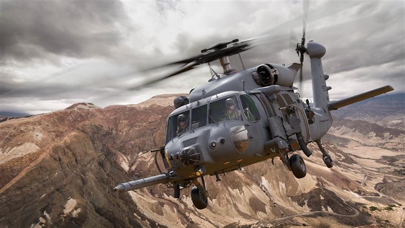
PlanetiQ has been awarded a $15 million, 48-month Strategic Funding Increase (STRATFI) contract by the U.S. Air Force. The program will support the development and launch of spacecraft equipped with next-generation GNSS radio occultation (GNSS-RO) and GNSS polarimetric radio occultation (GNSS-PRO) instruments and the delivery of high-value weather data to the U.S. Air Force.
The mission will focus on advancing GNSS-RO, GNSS-PRO and GNSS reflectometry (GNSS-R) capabilities. The program includes the development of advanced data assimilation techniques to integrate enhanced GNSS-PRO data into numerical weather prediction (NWP) models, improving forecast accuracy and enabling new insights into atmospheric conditions.
After spacecraft commissioning, PlanetiQ will provide on-orbit data delivery during the contract period. This will support multiple applications across the Department of the Air Force, including artificial intelligence (AI) model training, data assimilation, and performance evaluation.
As the largest commercial provider of GNSS-RO data, PlanetiQ operates a global constellation of satellites, including spacecraft equipped with advanced receivers capable of capturing high signal-to-noise ratio (SNR) GNSS-RO and GNSS-PRO measurements. GNSS-PRO has demonstrated strong efficacy for measuring precipitation, a key capability for improving severe weather forecasting.
This STRATFI award will enable the development of a next-generation receiver that adds GNSS-R capabilities, supporting new applications such as ocean surface wind measurement, sea state characterization, and soil moisture monitoring over land.
“This award represents a major step forward in delivering more advanced, actionable weather information to the warfighter,” said Ira Scharf, CEO of PlanetiQ. “By combining GNSS-RO, PRO and R measurements in a single platform, we are unlocking a more complete picture of the atmosphere and Earth’s surface. We are proud to partner with the U.S. Air Force to accelerate these capabilities and bring next-generation environmental data into operational use.”
Contract strengthens the company’s growing portfolio of U.S. government-funded PNT initiatives
TrustPoint has been awarded a $1.9 million Small Business Innovation Research (SBIR) Direct-to-Phase II contract focused on adapting and upgrading TrustPoint’s commercial C-band positioning navigation and timing (PNT) payload to integrate with U.S. Department of Defense (DoD) architectures and meet advanced government requirements.
The Air Force Research Laboratory and AFWERX, the innovation arm of the U.S. Air Force, have partnered to streamline the SBIR and Small Business Technology Transfer (STTR) process by accelerating the small business experience through faster proposal to award timelines, changing the pool of potential applicants by expanding opportunities to small business, and eliminating bureaucratic overhead by implementing process improvement changes in contract execution.
The Air Force began offering the Open Topic SBIR/STTR program in 2018, which expanded the range of funded innovations. Now, TrustPoint will accelerate its journey to create and provide innovative capabilities that will strengthen the national defense of the U.S.
TrustPoint is developing a low size, weight, power and cost (SWaP-C) payload designed to address the U.S. Space Force’s growing need for tactically responsive and resilient space capabilities. The upgraded payload will bolster resistance to GPS jamming and spoofing, and expand the operational resilience of PNT in contested environments — an essential requirement for future proliferated space architectures and for the autonomous systems, including drones, that depend on trusted timing and navigation.
The effort will culminate in laboratory testing in collaboration with the Air Force Research Laboratory (AFRL), setting the stage for potential Phase III deployment opportunities.
The award marks TrustPoint’s fifth Phase II SBIR in 18 months, spanning projects with the Air Force, Space Force and Navy, and adds to the company’s participation in government-funded PNT initiatives.
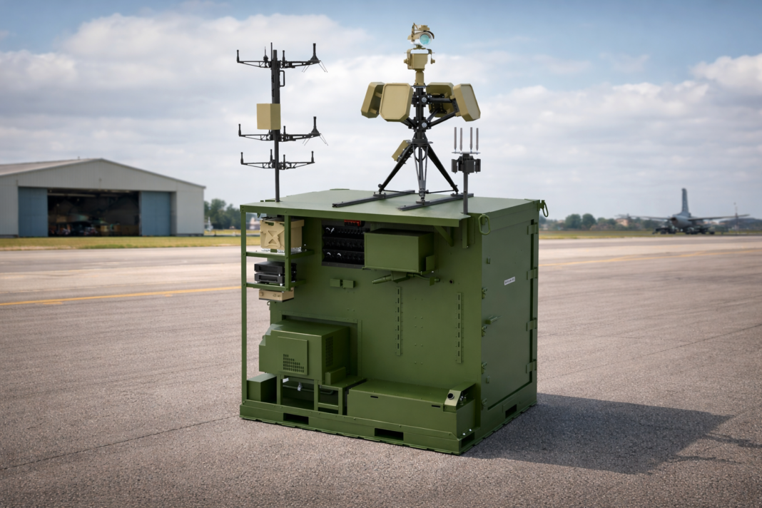
The U.S. Air Force has awarded Trust Automation a $490-million indefinite delivery, indefinite quantity (IDIQ) contract for the rapid research, development, prototyping, demonstration, evaluation, production and transition of unmanned and counterunmanned aircraft system (CUAS) capabilities.
As Trust Automation looks ahead to 2026 and beyond, this program represents a pivotal step in addressing the evolving challenges of modern warfare. Work will be performed at Trust’s facility in San Luis Obispo, California, and is expected to be completed by Aug. 20, 2030.
Image: Trust Automation
“We’re incredibly proud to have been selected for this critical C-UAS project,” said Ty Safreno, Trust’s chief executive officer. “This contract underscores our commitment to developing cutting-edge anti-drone technologies that address our most pressing security challenges, protect our armed forces and contribute to the safety of our nation.”
Trust is a field-proven leader in defense and counter-small unmanned aircraft system (C-SUAS) technologies to directly counter UAS activity in C2 and GNSS bands. At the core of its product suite is the Small-Unmanned Air Defense System (SUADS), which delivers fixed-site, such as Air Force base defense operations centers (BDOC), and rapidly deployable protection for key facilities and units in combat zones. These systems provide layered defense with adaptable modular solutions to detect, track and defeat Group 1, 2 and 2+ aircraft threats.
Complementing SUADS is the weapons-mountable GAT UAS Jammer, which enables personnel to directly counter UAS activity in GNSS bands. Together with a broader suite of radio frequency products, Trust equipes warfighters with scalable options to secure critical operations against evolving UAS threats.
As Trust Automation rolls into 2026, the company remains dedicated to its mission to deliver innovative, reliable and mission-critical technologies that empower the U.S. Air Force and other defense partners to stay ahead of emerging threats.
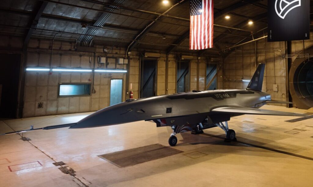
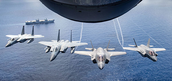
The U.S. Air Force is increasingly referring to its next generation of unmanned aircraft as “fighter drones,” as the service prepares to integrate these vehicles alongside traditional fighter jets in combat missions. The Air Force’s Collaborative Combat Aircraft (CCA) program includes two separate vehicles under development by General Atomics Aeronautical Systems (GA-ASI) and Anduril, both designed to operate as combat-ready UAVs. These UAVs are being built to complement existing fighter fleets, providing additional capabilities and support during operations. According to Air Force officials, the new aircraft are expected to play a key role in future air combat by flying alongside piloted fighters and taking on a variety of tactical missions.
One is an all-stealth design for undetected penetration of enemy defenses; the other is a sleek fighting companion.
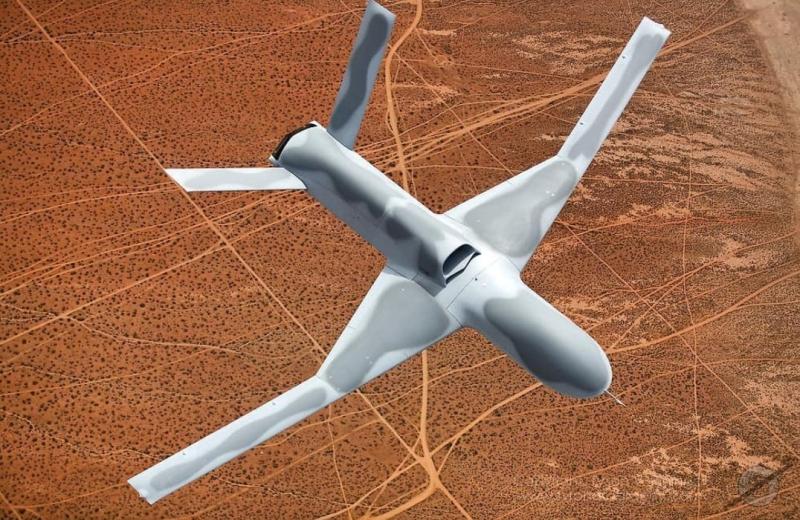
It appears the General Atomics YFQ-42A/CCA drew inspiration from the earlier stealth capabilities of the Avenger UAV, which has been in flight for more than a decade. This aircraft has a maximum ceiling of over 50,000 ft, flies at 400 mph, has around 15 hours of endurance and is powered by a built-in turbofan engine.
Avenger UAV (Credit: GA-ASI/Tyson Rininger)
One notable feature of the CCA version is its split, sloping “tailfin” and rounded design, along with a top fuselage air intake that shields the power plant from potential radar signals – all stealthy characteristics similar to those of its Avenger counterpart. Looking closely at the prototype, the doors on its belly appear to be for an internal weapons bay.
Another USAF CCA prototype, built by Anduril, has been named the FYQ-44. It features a sleek and fast design, similar to earlier pre-stealth fighters, but also includes an internal weapons bay, rounded contours, and an air intake below the fuselage for a turbofan engine.
The USAF’s release of these two CCA prototype contenders seems to suggest that they could be the fighter aircraft of the future. The CCA program, however, does talk about control of these armed UAVs by accompanying mainline manned fighter aircraft, but with autonomous capability to find and destroy once dispatched to attack a target.
The intent is that these unmanned fighters will be significantly less costly to acquire than their expensive manned brothers so that high-risk targets may still be attacked and destroyed without potential loss of the flying pilot or their expensive aircraft. The unmanned fighters would be programmed by the manned aircraft and missiles in their internal weapons bay, would then go on to be controlled by onboard CCA weapons systems, which would relay data back continuously to the pilot who would have final go/no-go authority.
Both prototypes are slated to fly later this year following extensive ground testing campaigns.
After securing an initial $60 million contract from the USAF in 2021, Hermeus went on to raise $100 million in funding in 2022. This was followed by an investment from Raytheon Technologies’ RTX Ventures later that year. Additionally, the company landed a contract for Hypersonic risk reduction from the Defense Innovation Unit (DIU), allowing Hermeus to maintain its funding and momentum. This enabled the company to build and recently fly its first unmanned aircraft, which is designed to travel at extremely high speeds, according to the company.
Initially, with an integrated GE J85 engine, Hermeus is now launching the incorporation of the Pratt & Whitney F-100 into its own “Chimera II turbine-based combined cycle (TBCC) propulsion system,” all aimed at taking subsequent iterations of their prototype to hypersonic speeds.
Quaterhorse has been developed to demonstrate high-speed take-off and landing of a large unmanned aircraft, and is the first in a series of prototypes. And a couple of months ago, on May 27 at Edwards Air Force Base (AFB) in California, Quaterhorse did in fact take off, performed a short overhead circuit and landed! So, more flight tests are now expected to explore the drone’s flight characteristics.
The TBCC two-phase engine with the Pratt F-100 front-end is slated to take Darkhorse, the next planned drone derivative, to Mach 2.8 on the F-100 and then up to over Mach 5 with the hypersonic back-end section of the engine. It could be said that the whole vehicle is being built around this monster engine!
It will be interesting to see how flight testing of Quaterhorse progresses, but even more exciting to hopefully see if and when Hermeus gets the next hypersonic version flying. Additionally, we can anticipate the first flights of the USAF CCA prototypes.
It is amazing how, from the humble beginnings of hobbyist radio-controlled recreational model aircraft, drones have evolved with sophisticated autopilots and are now becoming autonomous vehicles that are taking on front-line air force attack-support. Technological progress is now headed towards hypersonic capability.
The Air Force was initially opposed to GPS. How did that change?
Between 1978 and at least the mid-1980s, maybe even the late 1980s, the Air Force tried several times to cancel the program. At the time, I was a Capitol Hill staffer for the House Intelligence Committee. In one of those efforts to cancel GPS, Tom Cooper, who was a lead staffer for the House Armed Services Committee, came to me and said, “Can you guys give any reason for keeping GPS?” And I said, “Yes, it greatly improves the accuracy of SIGINT [signals intelligence] locations. It makes a very big difference.”
So, Tom used that, along with other arguments, for why we should keep GPS. The Committee and Congress ultimately decided they would, despite the Air Force’s resistance.
The Air Force’s resistance came from the Strategic Air Command, which in the 1980s believed it would never use satellites. They were concerned about the satellites being shot down. I found this amusing because they were flying around in aircraft at a few thousand feet and were concerned about satellites flying at 11,000 miles. But they were, so they were laggards.
Image: USAF/Staff Sgt. Kyle Johnson
Which service adopted GPS first and why?
The service that by far led the way was the Army. It spent $100 million a year absorbing NRO capabilities. They also spent money on GPS, though not as much. By the time we got to the first Gulf War, in 1991, we had a partial GPS constellation — I think of 18 satellites of the 24 required — and that meant that you didn’t have 100% coverage all day long. So, coverage maps of their areas of interest were generated every day to let people in the field know when they would have service. Most of them didn’t have receivers either. Most of the receivers they did have were Precision Lightweight GPS Receivers (PLGR), knows as “pluggers”, which were the first “handheld” receivers, but they were pretty big.
Once the fight got going, many of the troops wrote home and asked their moms and dads to send them civilian receivers.
Yes! Thousands and thousands of them showed up in theater. Some troops taped them to the windscreens of their helicopters or jet aircraft. They were just jury-rigged into everything because, despite their limitations at the time, they were very, very useful, unlike anything else. So, now everybody realized, “Oh my goodness, this is really a big deal. This is a game changer!”
Then we got more modern receivers, integrated receivers, the whole thing. However, at the end of the Gulf War, the Air Force still had no plan to equip any of its aircraft with GPS. As Assistant Secretary of the Air Force, I was called over to the Armed Services Committee and asked, “What is your plan for integrating GPS receivers into your aircraft fleet?” I said, “There is no plan.” and they were incredulous. They looked at me like “Well, you’re an idiot.”
It wasn’t me, however, and the staff knew my story before I gave it. As a result, Congress mandated it. They put it in that year’s National Defense Authorization Act (NDAA). Within less than 10 years you had Joint Direct Attack Munitions (JDAM) and other GPS-guided weapons. So, that got it moving quickly.
By the end of the 1990s, the Air Force was fully on board and were equipping their aircraft with many weapons that depended on GPS. Meanwhile, GPS had moved to a full constellation of 24 satellites. Full operating capability was declared in 1995. The Navy proceeded similarly, but they were somewhat less affected. So, the Army remained a leader in using space.
The Chief of Staff of the Air Force asked me about Air Force use of GPS. I said, “Chief, the Air Force builds a lot of space stuff, but it doesn’t use it.” Of course, a short time later it was using it extensively. So, this ramp-up was very rapid — just a few years from “I don’t give a darn about these things” to “I can’t live without them.”
Brad Parkinson and his successors as JPO directors designed and built the system but had no role in its adoption, right?
No. They were going turn it over to the production house, if you will, and they did. Once the Air Force got on board with GPS guided weapons, adoption proceeded rapidly.
What about the Navy?
I don’t recall the Navy particularly. I do not at all accuse them of being laggards. I think they did what they needed, whatever that was.
Did later NDAAs expand that mandate to the other services?
I don’t know. I was out of the government by that time, so I lost track. I don’t think it was necessary. What people didn’t understand immediately was that you could do anything with this system. At the end of the day, it is a super accurate timing signal. There are many things you could do with that and people have done them. It quickly became evident that it was so pervasively useful, that anything you could think of involves GPS, from the era of the first Gulf War onward. By 10 years later, many weapons systems in all the services were GPS-guided. I later served on the board of ATK and we were building GPS-guided artillery rounds. I am pretty sure that the ATACMS [Army Tactical Missile System] you hear about today is GPS guided.
So, in a couple of years, all the services wanted to integrate GPS in all their platforms and weapons.
Well, except that the amazing thing was, despite all the things that people had done with GPS in the Gulf War — starting with those helicopters that went in the first night and took out the command and control system, which were guided by Army-provided pluggers taped onto the windscreens by their pilots, and downed pilots using GPS to give their coordinates to the rescue teams — at the end of the war the Air Force still didn’t have a plan to put them on its aircraft! That’s when Congress mandated it. It was amazing.
Despite that, once they got going, particularly once they got going with GPS-guided weapons, everything changed. I don’t know whether the Air Force became leaders, but they were certainly aggressive integrators of the program into the service. There was no more, “We won’t use satellites” and all that.
That was after my time. I left government in early 1993. There were other big fish to fry at the same time. As important as I realized it was, I still didn’t realize how important it was, and I was way ahead of most everybody else, in the Air Force anyway.
The Federal Aviation Administration’s (FAA’s) chief scientist at the time said, “The great thing about GPS is that it is a tool around which you can build myriad capabilities.” He outlined a few for the FAA, many of which they have since done. The same thing began to happen in the services, particularly in the Air Force, in which GPS-guided weapons were pervasive within 10 years.
Part of Brad’s motto for JPO was “The mission of this program office is, number one, to drop five bombs in the same hole.”
Yeah. By the way, one mistake that people make a lot is they think there were GPS-guided weapons during the first Gulf War. That was not the case. There were none by then. There were precision guided munitions that were guided by maps and lasers and a variety of means. But, despite the belief of many authors, there were no GPS-guided weapons at that time.
So, which was the first conflict in which GPS was used?
It was the Iraq War, in 2003. It was a major user of GPS-guided weapons.
Any other thoughts on the 50th anniversary from the military side of things?
It is impossible to overemphasize the importance to military operations and, frankly, to civilian life as well, of being able to easily and accurately navigate or have highly accurate time.
You can do it with a $100 receiver, whereas it used to require a $10,000 receiver and you had to have it re-initialized from a standard. So that’s what everybody does. Now, this has created probably more dependency than is healthy and many nations have backup that we don’t have.
Such as Loran-C. That’s a big subject of debate these days, as you know.
Well, it’s been a subject of debate for 20 years. Everybody agrees, but nobody moves.
The Department of Transportation recently released an action plan on the adoption of complementary PNT systems. So, there’s some movement.
As a one-time government bureaucrat, what you do when people are on your back is launch a study and say, “Well, it will be done in a year or two.” They have done this time, after time, after time.
Vigilant Aerospace Systems, a provider of multi-sensor detect-and-avoid safety systems for UAVs and advanced air mobility (AAM), has been awarded a contract by the U.S. Air Force to develop a detect-and-avoid system for the Air Force’s new long-endurance UAV.
According to the published project description, the objective is to “integrate a mature detect and avoid capability on an existing long-endurance, Group V UAS platform, for increased aircraft and pilot-in-the-loop operational awareness that leverages new and evolving C-SWaP sensors and sensor fusion software.”
The project is sponsored by the Air Force Research Lab (AFRL) and is a Small Business Innovation Research (SBIR) Phase II project through the SBIR program. The program is designed to bring dual-use technologies, which can help both civilian and military users, into the military, with a focus on high-impact, near-term implementations.
FlightHorizon is detect-and-avoid and airspace management software that combines data from aircraft transponders, radar, UAV autopilots and live Federal Aviation Administration (FAA) data to create a single picture of the airspace around a UAV. The software displays air traffic, predicts trajectories and provides avoidance commands to the remote pilot or autopilot. The system can be used on the ground or onboard the UAV and can be configured for any size of aircraft.
The software is based on two licensed NASA patents and the company has completed contracts with NASA, the FAA and a project with the USAF’s 49th Operating Group’s MQ-9 Reaper fleet to track training flights. It is designed to meet industry technical standards and to help UAS operators fly beyond visual line-of-sight (BVLOS).
The new Air Force project incorporates prior research and development by the company in solving the automatic self-separation and collision avoidance problem for UAVs. To evaluate sensors and algorithms and establish standards-compliance and risk ratios, the company has completed hundreds of hours of flight tests with the system and thousands of simulated aircraft encounters inside the software’s built-in simulation engine, according to Vigilant Aerospace Systems.
Colorado Springs, Colorado, and its vicinity are home to several key U.S. military organizations.
To the northwest is the U.S. Air Force Academy, which educates cadets for service in the officer corps of the United States Air Force and United States Space Force.
To the southwest, deep inside Cheyenne Mountain, is the North American Aerospace Defense Command (NORAD), a United States and Canadian organization charged with detecting, validating and warning of attacks against North America, whether by aircraft, missiles, or space vehicles. In a crisis, the four-star general in command of NORAD would pick up a direct line to the White House and tell the president whether nuclear armed missiles were on their way to the United States. He also commands the United States Northern Command, which is charged with defending the continental United States and Alaska.
I visited these two facilities 35 years ago, when I was a graduate student in international security at MIT. (The Air National Guard flew our group of MIT and Harvard students from Hanscom Air Force Base, near Boston, to Colorado Springs, with a stop at Offutt Air Force Base, home of the U.S. Strategic Command. One of the first Northrop B-2 Spirit, aka the Stealth Bomber, was there, under a tarp. A Harvard student decided to use the stop to go for a run. The MPs promptly arrested him and his professor had to bail him out, much to the amusement of us MIT students.)
In the southeast corner of the city is Peterson Space Force Base. To the east is the one that is of greatest interest to readers of this magazine: Schriever Space Force Base, the home of the GPS Master Control Station.
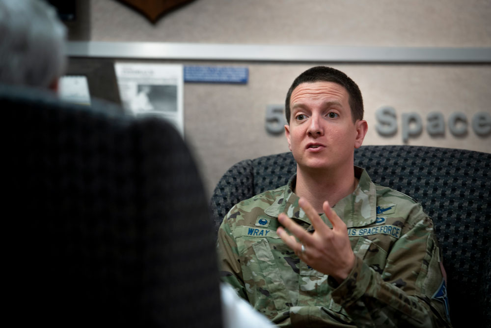
I recently visited the MCS at the invitation of Lt. Col. Robert O. Wray, Commander, 2nd Space Operations Squadron, which operates it. You can read excerpts of my interview with him here.
Wray gave me a tour of the MCS operations floor. During the tour, I was able to look at the dozens of computer monitors used by the GPS operators and to ask them many questions about their jobs. At any moment, 10 of them are on duty — eight uniformed military personnel and two civilian contractors. Later, I followed up with two members of the GPS Warfighter Collaboration Cell, which supports warfighters, combatant commands and, through the U.S. Coast Guard Navigation Center, more than four billion global civilian users.
Near the end of the tour, Wray surprised me with a question: “Would you like to send a command to a GPS satellite?” You can imagine my prompt answer. A moment later, I was seated at one of the consoles and entering an alpha-numeric string that I was copying from one of the screens. I was so delighted by the opportunity and so focused on entering the sequence correctly that I forgot to ask what command I was sending! Whatever it was, I assume it will help you get to your destination.
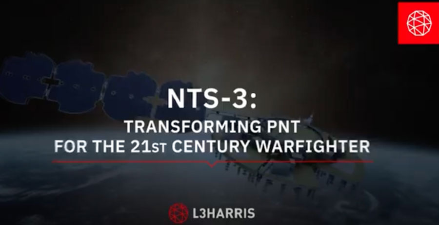
The Navigation Technology Satellite–3 (NTS-3) — designed, built and tested by L3Harris — is on track to launch this year. The experimental satellite aims to shape the future of U.S. positioning, navigation and timing capabilities and to help U.S. forces to operate in GPS-denied environments and areas prone to spoofing.
NTS-3 minimizes the impacts of GPS jamming through rapidly reprogrammable signal waveforms, frequency agility and increased signal strength. Its embedded software and firmware are reprogrammable on-orbit.
When paired with reprogrammable receivers, the U.S. Air Force and U.S. Space Force can react in real time as threats evolve on the battlefield. In addition, NTS-3 has enhanced processors to support more complex signals.
In January, L3Harris delivered the NTS-3 vehicle to Kirtland Air Force Base, New Mexico, to prepare the satellite for launch. The Air Force Research Laboratory and L3Harris are working together to complete space vehicle testing, launch vehicle integration and enterprise integration to confirm compatibility between the control segment, ground receivers and the satellite vehicle.
NTS-3 is scheduled to launch later this year aboard United Launch Alliance’s Vulcan Centaur rocket. Once launched, NTS-3 will remain in a near-geosynchronous orbit for an inaugural year of testing.
Lt. Col. Robert O. wray commands the 2nd Space Operations Squadron (2 SOPS), which operates GPS around the clock supplemented by members of the 19th Space Operations Squadron (19 SOPS). (Credit: U.S. Space Force photo by Dennis Rogers)
Exclusive GPS World interview with the commander of the unit that operates the GPS constellation
The entire Global Positioning System constellation comprised of 38 satellites — with its billions of users and myriad military, commercial, consumer and scientific applications — is controlled from one room in a gray office building on a small military base about nine miles east of Colorado Springs, Colorado. The base is Schriever Space Force Base (SFB) and the room is the “operations floor” of the GPS Master Control Station (MCS). It is staffed by members of the 2nd Space Operations Squadron (2 SOPS), an active-duty unit of the U.S. Space Force, supplemented by members of the 19th Space Operations Squadron (19 SOPS), a unit of the U.S. Air Force Reserve. The two squadrons are known collectively as “Team Blackjack.”
Lt. Col. Robert O. Wray is the commander of 2 SOPS and of those 19 SOPS members assigned to the MCS. On March 16, at Schriever SFB, Wray spoke at length with GPS World’s editor-in-chief, Matteo Luccio, about the training and duties of his team members, the challenges they face, and what brought him to his current assignment. He then gave Luccio a tour of the MCS and introduced him to each of the 10 people on duty. At any given time, eight of these operators are military personnel and two are civilian contractors. They receive feeds from a worldwide network of monitor stations and ground antennas, including telemetry from the satellites, that enable them to precisely monitor the satellites’ orbits and the state of their systems. The operators upload data and commands to the satellites around the clock to keep the constellation fine-tuned and respond to changing circumstances.
An abridged version of the interview will appear in the May issue of GPS World. A longer version will appear here on May 1.
CMC Electronics has entered a multi-year contract with Sikorsky, a Lockheed Martin company, to supply its CMA-2082MC military flight management system (FMS) for several Sikorsky helicopter models, including the UH-60M, HH-60M, HH-60W, S-70i and the S-70M.
CMA-2082MC is a complete FMS with integrated radio management, which provides centralized control of navigation sensors, communication radios, mission avionics and more. It is also highly reliable while operating in harsh environments.
The helicopters complete with CMA-2082MC military FMS will be delivered to the U.S. Army and the U.S. Air Force, as well as several Black Hawk customers for use in a wide range of missions including search and rescue, troop transport, medical evacuation, disaster relief, aerial firefighting and border patrol.
A demonstration airspace management system is playing a role during the military exercise Rim of the Pacific (RIMPAC) 2022, taking place in Hawaii and Southern California.
FlightHorizon COMMANDER, provided by Vigilant Aerospace to the U.S. Air Force, is an airspace management and detect-and-avoid system based on two licensed NASA patents. The system can be used on the ground or onboard aircraft and is designed to help keep unmanned aircraft systems (UAS or drones) safe and collision free.
For the first time, U.S. Air Force MQ-9 UAS — also known as a Reaper — is taking part in a RIMPAC exercise. RIMPAC is the world’s largest international maritime exercise, involving more than 40 ships, 30 UAS and 150 aircraft from 27 partner nations.
RIMPAC 2022 is the 28th exercise in the series that began in 1971. The 2022 exercise takes place from late June to early August.
The FlightHorizon COMMANDER demonstration system (non-U.S. Air Force) tracks air traffic in Hawaii in 2022. (Photo: Vigilant Aerospace)
FlightHorizon COMMANDER includes a 3D moving map display for air traffic situational awareness, air navigation charts, weather data, special features for the tracking and safety of uncrewed aircraft systems (UAS) and automatic detect-and-avoid functions.
The airspace management system correlates and displays air traffic and other data from a wide variety of sources including ground-based and airborne sensors, civilian air traffic data, military data and proprietary data sources. The dual-use technology provides automatic traffic warnings and deconfliction as a built-in function.
The product is based on two licensed NASA patents and has been used in ongoing NASA supersonic projects, in FAA detect-and-avoid projects, and in civilian UAS projects around flight corridors and drone ports.
“RIMPAC 2022 marks the first appearance of the MQ-9A Reaper, a remotely piloted aircraft, and its presence brought in military teams from California, New Mexico and Nevada,” the Air Force stated. “With personnel from both the active-duty element, Reserves and Air National Guard, the collective group ensures that it is fully operational. All the while, everyone learns new techniques that it will take to improve their day-to-day operations upon returning home.”
“Vigilant Aerospace is thrilled to support this large-scale exercise,” said Kraettli L. Epperson, CEO of Vigilant Aerospace. “Support of this exercise is an especially useful demonstration of the multi-sensor and multi-data source capabilities of FlightHorizon and the ability to track hundreds of targets simultaneously.”
Vigilant Aerospace holds a U.S. Department of Defense IDIQ to support military adoption of the system for UAS and airspace safety.
The 2022 Public Interface Control Working Group and Open Public Forum will take place virtually on Sept. 28, the U.S. Air Force has announced. It is hosted by Space Systems Command, Military Communications and Positioning, Navigation, Timing Directorate.
The following NAVSTAR GPS public documents will be discussed:
IS-GPS-200 (Navigation User Interfaces)
IS-GPS-705 (User Segment L5 Interfaces)
IS-GPS-800 (User Segment L1C Interface)
ICD-GPS-870 (Control Segment [OCX] to User Support Interface).
The virtual meeting can be accessed via the following dial-in numbers and links: