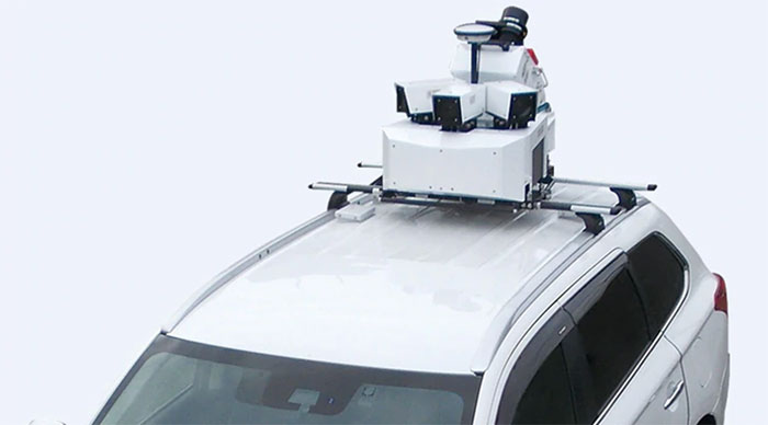
The Topcon GTL-1000 transforms construction layout and as-built verification from infrequent spot checking to a digital real-time reality capture solution enabling layout, scanning and verification with daily frequency. A scanner integrated with a fully featured robotic total station, it provides quick layout and scanning with a single instrument and only one operator that drives increased productivity and cost savings.
Author: Allison Kral
-
Tersus GNSS launches Oscar GNSS receiver at Intergeo 2019
Tersus GNSS President and CEO Xiaohua Wen gives GPS World an overview of the company’s Oscar GNSS receiver at Intergeo 2019 in Stuttgart, Germany. According to the company, the Oscar GNSS receiver offers calibration-free tilt compensation that is immune to magnetic disturbances.
-
Mitsubishi Electric launches High Precision Positioning Systems Division

According to Mitsubishi Electric, its Mobile Mapping System uses car-mounted GNSS antennas, laser scanners and cameras to gather 3D positioning data for road assets with high-level accuracy. (Photo: Mitsubishi Electric) Mitsubishi Electric Europe B.V. has established a High Precision Positioning Systems Division at its German branch headquarters in Ratingen, Germany.
According to the company, the new division offers key technologies to German and European customers to accelerate the introduction of centimeter-level autonomous driving and safe driving assistance. These solutions include the Mobile Mapping System (MMS) and the high-precision AQLOC positioning receiver with centimeter-level accuracy for applications in road and utility vehicles, harbors and drones, as well as the agricultural sector.
AQLOC will be compatible with GNSS services and positioning data augmentation services by Sapcorda, a joint-venture by Mitsubishi Electric, Bosch, Geo++ and u-blox. MMS uses car-mounted GNSS antennas, laser scanners and cameras to gather 3D positioning data for road assets with high-level accuracy, creating the comprehensive, high-definition 3D maps needed to support autonomous driving, the company said.
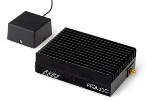
The high-accuracy positioning receiver AQLOC will be compatible with GNSS services and positioning data augmentation services provided by joint venture Sapcorda. (Photo: Mitsubishi Electric) “We are happy to add this new business area to our wide-ranging mobility solution portfolio, which already includes automotive equipment, power devices and railway systems,” said Andreas Wagner, president of the German Branch of Mitsubishi Electric Europe B.V. “The High Precision Positioning Systems Division rounds out our mobility sector and will offer German and European customers essential technologies for highly precise autonomous driving systems in a variety of scenarios.”
Mitsubishi Electric Corporation is making mobile mapping and high-precision positioning systems available in Europe, North America, Asia and Oceania. The company also will showcase the new business unit’s portfolio at Intergeo 2019, which will take place Sept. 17-19 in Stuttgart, Germany.
-
ComNav Technology introduces T3 GNSS receiver at Intergeo 2019
ComNav Technology’s Roy Luo discusses the features of the company’s T3 GNSS receiver, which was launched at Intergeo 2019.
-
Topcon showcases GTL-1000 scanner at Intergeo 2019
Topcon Positioning Group displayed its GTL-1000 scanner at Intergeo 2019, which took place Sept. 17-19 in Stuttgart, Germany. According to the company, the GTL-1000 is a compact scanner integrated with a fully featured robotic total station, enabling a site engineer to complete a layout and scan on a single setup.
-
KVH showcases TACNAV 3D at ION JNC 2019
KVH Industries’ Bill Houtz offers an overview of the KVH TACNAV 3D, a fiber optic 3D inertial navigation systems with embedded GNSS, at the Institute of Navigation’s 2019 Joint Navigation Conference in Long Beach, California. According to the company, TACNAV 3D’s modular tactical design and flexible architecture allow it to function as either a standalone navigation solution or as the core of a multi-functional Battlefield Management System.
-

Bentley Systems to cover smart city technology at Intergeo 2019

At Intergeo 2019, Bentley Systems will be focusing on digital construction, digital cities, reality modeling and civil design. (Photo: iStock.com/alexsl) Bentley Systems will be focusing on smart cities, specifically digital twins for digitally advanced smart cities and other technology solutions, at Intergeo 2019, which will take place Sept. 17-19 in Stuttgart, Germany.
During the show, the company will offer demonstrations and discuss digital construction, digital cities, reality modeling and civil design. In the realm of digital construction, Bentley Systems will cover the use of a mixed reality solution for 4D construction featuring Bentley’s SYNCHRO (4D construction software) with Microsoft HoloLens.
The company also will demonstrate how its OpenCities Planner software enables visualization of 2D, 3D and GIS data in a 3D world. Bentley colleagues will discuss how OpenCities Planner’s capabilities combined with Bentley’s reality modeling offerings make city-scale digital twins broadly accessible, the company said.
In addition, the company will key in on reality modeling, including the process of capturing the physical reality of an infrastructure asset, creating a representation of it and maintaining it through continuous surveys. Bentley experts also will demonstrate the use of ContextCapture, which enables users to generate spatially-classified and engineering-ready reality models at any desired level of accuracy and scale, including entire cities.
Finally, the company will discuss how civil design can be made better though its open applications, including OpenRoads, OpenSite and OpenRail.
During the show, Robert Mankowski, vice president of Bentley Systems’ Digital Cities Business Unit, will present a keynote on Sept. 18 titled, “The Digitally Advanced City: Trusted Information Whenever and Wherever Needed.” Håkan Engman, business development director of reality modeling at Bentley Systems, also will present a spot talk on Sept. 19 titled, “Digital Transformation for Increased Efficiency and Sustainability.”
Bentley Systems will be in Hall 3 at booth A3.010 at Intergeo.
-
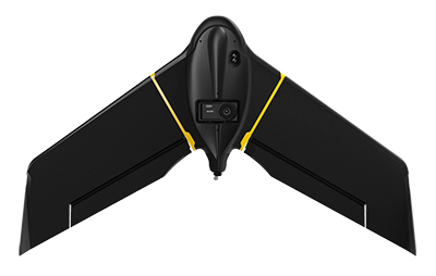
SenseFly to demo drone solutions at Intergeo 2019
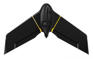
The eBee X. (Photo: senseFly) SenseFly, a drone solutions provider, will be demonstrating its drone solutions at Intergeo 2019, which will take place Sept. 17-19 in Stuttgart, Germany.
According to the company, visitors to its booth will be able to explore the flexibility of senseFly’s eBee X drone and its role in optimizing GIS and surveying workflows to achieve high quality outputs, such as centimeter-precise 3D point clouds, orthomosaics and digital surface models.
Attendees will be able to learn about the range of payloads and software solutions the eBee X platform can be used with, including the senseFly Aeria X, senseFly Duet T, senseFly S.O.D.A., senseFly S.O.D.A. 3D, MicaSense RedEdge-MX and Parrot Sequoia.
The senseFly team will also be hosting a series of Meet the Experts sessions on-stand featuring guest speakers and demos from senseFly partners such as Pix4D, ALLNAV and Harxon. The 10-minute talks will be followed by Q&A sessions.
“Our expert team also enables us to deliver the knowledge and insight our users need to navigate the changing landscape as drone technology continues to garner greater public and legislative attention worldwide,” said Gilles Labossière, CEO of senseFly. “Our customers’ needs are constantly evolving, and it’s vital for us to ensure that our products and solutions are as dynamic and versatile as they are to meet their unique and complex challenges.”
SenseFly’s can be found at booth B3.078, Hall 3, at Intergeo 2019.
-
Thank you for registering.
Thank you for registering for the upcoming webinar, “GPS/GNSS Spoofing & Jamming: Threats and Countermeasures,” an event coordinated by our editorial team and brought to you by Orolia.
A link to the live event will be sent to you two hours before the event. Your personalized event URL will be automatically generated by the ON24 system. To ensure receipt of the email, please whitelist this email address by adding it to your contacts: [email protected].
This presentation will begin on at 1 p.m. EDT / 10 a.m. PDT on Thursday, Sept. 12.
Audience members may arrive 15 minutes prior to live time. If you have any questions, please contact event producer James Webb at [email protected] or digital media manager Allison Barwacz at [email protected].
-

Amazon fires in Brazil can be seen from space
Wildfires in the Amazon rainforest in Brazil have hit record numbers, and satellites have been able to capture imagery of them.
According to NASA, the Moderate Resolution Imaging Spectroradiometer on its Aqua satellite captured images of several fires burning in the states of Rondônia, Amazonas, Pará and Mato Grosso on Aug. 11 and Aug. 13.
A satellite view of the Amazon wildfire on Aug. 13. (NASA Earth Observatory images by Lauren Dauphin, using MODIS data from NASA EOSDIS/LANCE and GIBS/Worldview and VIIRS data from NASA EOSDIS/LANCE and GIBS/Worldview, and the Suomi National Polar-orbiting Partnership.) There have been 72,843 fires in Brazil this year, with more than half in the Amazon region, Brazil’s space research center, the National Institute for Space Research (INPE), said. This marks an 84% increase over the same period of 2018 and is the highest since records began in 2013, INPE added.
Amazonas, the largest state in Brazil, recently declared a state of emergency over the forest fires, said Euro News.
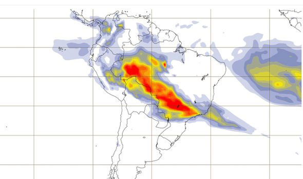
This map shows the “Biomass burning aerosol optical depth.” (Image: Copernicus’ Atmosphere Monitoring Service) In the Amazon region, fires are rare for much of the year because wet weather prevents them from starting and spreading. However, in July and August, activity typically increases due to the arrival of the dry season, NASA said.
-

Topcon to demo BIM, construction technology at Intergeo 2019

Topcon Positioning Group will be showcasing its vertical construction, construction management, and structural health and inspection technology at Intergeo 2019. (Photo: Topcon) Topcon Positioning Group will be demonstrating its technology offerings across vertical construction, construction management, and structural health and inspection at Intergeo 2019.
Topcon will present its new building information modeling (BIM) technology at the show, which includes the Topcon vertical construction workflow. The Topcon vertical construction work flow includes the Laser Scanning Robotic Total Station GTL-1000, MAGNET Collage and ClearEdge3D Verity software.
According to the company, the full workflow is designed to offer a powerful instrument for single-operator layout and scan on a single set up. It will also be releasing new innovative digital layout solutions alongside the GTL-1000 to enhance the VC portfolio and widen the options available to customers for this critical task.
Topcon will also be showcasing its inspection, assessment and monitoring solutions, which are designed to keep infrastructure assets in operation by providing reporting tools for site engineers and monitoring structural health.
Topcon added that it will be demonstrating its GTL-1000 and accompanying software MAGNET and ClearEdge3D Verity at the show. Its booth will also feature interactive displays that will provide virtual looks at job sites.
“Productivity is a huge talking point in our industry, so this year at Intergeo we’re proving that Topcon is always one step ahead, working in partnership with the construction and infrastructure sectors to provide solutions and products to address the big issues,” said Ian Stilgoe, vice president of Geopositioning Europe at Topcon Positioning Group. “Whether it’s quicker, simpler verification, or smart inspection and monitoring of aging assets, the need for digital innovation is greater than ever.”
Topcon’s demonstrations will be taking place at its booth, F3.013, in hall 3.
-
Epson displays SureColor T5470M at Esri UC 2019
Epson’s Matt Kochanowski offers an overview of the company’s SureColor T5470M printer and scanner at the 2019 Esri User Conference in San Diego. According to the company, the SureColor T5470M, which combines a 36-inch printer and integrated scanner, can produce accurate A1/D-size prints in as fast as 22 seconds.
