Collins Aerospace announced that its miniature PLGR engine – M-code (MPE-M) receiver has received approval from the GPS Directorate. Collins Aerospace’s Mike Shepherd talks more about the approval at Xponential 2019, which took place April 29-May 2 in Chicago.
Author: Allison Kral
-

Intergeo 2019 to highlight geodata

Intergeo 2019, which is set to take place Sept. 17-19 in Stuttgart, Germany, will cover a number of key geodata topics. The main topics highlighted during the conference will include smart cities, campus geoinnovation, digitalization, building information modeling, emphasis on local authorities and UAVs.
More than 680 exhibitors will be providing insights into the highly dynamic geospatial sector, event organizers added.
“Geodata forms the foundation for our digital society and is thus becoming the currency of the future,” said Hansjörg Kutterer, president of the German Society for Geodesy, Geoinformation and Land Management. “These developments are exciting and our industry is not just affected by them — it is actively shaping them.”
According to event organizers, the show will show what digital change in the field of geoinformation means. Keynote speakers for Intergeo 2019 include Dr. Markus Kerber, state secretary at the Federal Ministry of the Interior, Building and Community; Dr. Juergen Dold, president, of Hexagon’s Geosystems Division; and Hashem Al-Ghaili, director of content at Futurism.
Kerber will cover smart homeland and how digitalization can help achieve equal standards of living. Dold will discuss opportunities through digital business models. Finally, Al-Ghaili will present new ways of communicating science.
-
uAvionix introduces truFYX GPS, transponder at Xponential 2019
uAvionix Chief Operating Officer Ryan Braun discusses the company’s truFYX GPS and transponder at Xponential 2019, which took place April 29-May 2 in Chicago.
-

XM2 drones play pivotal role in film industry
When it comes to producing film imagery, it’s all about perspective.
Picture this: You’re in a courtyard surrounded by four high-rise buildings, looking up. You’re tasked with flying a drone equipped with a movie camera between two of the buildings, and then up one of them.
It’s a challenge, but perspective is critical when it comes to filming technology-focused movies like Pacific Rim: Uprising.
High-resolution imagery has become a critical component for Hollywood film producers over the years, and drones have played a paramount role in offering unique viewpoints.
More importantly, drones allow users to capture imagery that humans alone can’t produce.
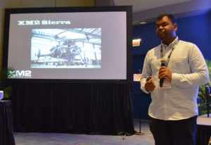
XM2’s Aaron Corera discusses the company’s drone imagery at Xponential 2019. (Photo: Allison Barwacz) XM2, an aerial cinematography and photography company based in Melbourne, Australia, uses drones to capture this compelling imagery. The company has worked on a number of big-name projects, including Pacific Rim: Uprising, Thor: Ragnarok, Aquaman, season two of Westworld, Pirates of the Caribbean: Dead Men Tell No Tales and Star Wars: Episode IX.
“Star Wars: Episode IX was certainly a big challenge,” said Aaron Corera, drone pilot and safety manager at XM2, at an education session at Xponential 2019. “It was a massive challenge logistically to get all of our equipment over there, and then in an environment where there’s very little infrastructure, essentially, to be able to do some high-pressure tasks. It’s just a matter of being well prepared, being switched on and working through a checklist to make sure every box is being ticked.”
The company has manufactured a number of its own drones to meet the needs of its clients. One of its drones — the XM2 Sierra — is capable of carrying payloads up to 66 pounds.
“It is designed to be able to carry cameras that traditionally aren’t drone-based cameras,” Corera said. “That aircraft can carry the same cameras that are being used for the ground-based shooting, and that’s a big advantage. Having all platforms using the cameras saves them time in post-production.”
The company’s other house-manufactured drones include the Tango, Echo and Inspire Pro 2, which have been deployed over a number of the company’s projects.
The work didn’t come immediately, though. The 14-person staff at XM2 has only been working in the film industry for about seven years, Corera said.
“The work came in bits and pieces, and we gained momentum into it a little bit, then realized, ‘There’s a real opportunity here,’” he added.
One of the biggest challenges the company has had to face is unfamiliarity with the products and what XM2 can offer.
“I think one of the challenges includes familiarity, ultimately,” Corera said. “And that’s familiarity in the systems for the client and what it can and can’t do.”
Because a lot of people aren’t familiar with drones and the legal requirements to fly them, XM2 has had to find alternatives for client requests, as well as educate and ensure the safety of the people working around them.
“From the people management side of things, when we’re operating on a film set, it’s about coordination between the people that are involved in the shot itself and then the people that are managing the film set,” Corera said. “And then there will generally be on-set safety, as well. We’ll have a briefing in the morning, and explain what we’ve got planned for the day.
“When it comes to a specific shot, we take it upon ourselves to know exactly where everyone is, exactly what they’re doing and where they’re going. We make sure everyone knows what the plan is and what to do in case something goes wrong. It’s a combination of technical safety protocols and people safety protocols.”
Still, as technology evolves, the demand for high-resolution, drone imagery does, too. It’s all about perspective and, more importantly, capturing imagery from a viewpoint otherwise unseen.
-

Honeywell emphasizes ruggedized feature of IMU at Xponential 2019

Photo: HoneyWell Honeywell displayed its HG4930 MEMS-based inertial measurement unit (IMU) at Xponential 2019, which took place April 29-May 2 in Chicago.
The company emphasized the IMU’s rugged design, which the company says allows the IMU to meet the needs of the most demanding users. The HG4930 also features gyroscopes, accelerometers and an internal environmental isolation system.
Check out the video below, which showcases the HG4930 being treated as a hockey puck.
According to Honeywell, the HG4930 can be used for applications in the agriculture, automotive, communication, construction, energy, inspection, mapping, marine, mining, robotics, surveillance and transportation industries.
-
Topcon showcases Falcon 8+ drone, Sirius Pro and receiver boards at Xponential 2019
Topcon Positioning Group’s Dave Henderson offers a rundown on the company’s latest products, including the Falcon 8+ drone, Sirius Pro, MR-2 modular receiver, and B210 and B125 receiver boards, at Xponential 2019.
-
SBG Systems debuts line of inertial navigation systems at Xponential 2019
SBG Systems debuted its Quanta UAV series, a new line of inertial navigation systems (INS), at Xponential 2019, which took place April 29-May 2 in Chicago.
According to the company, the Quanta UAV is a small, lightweight and low-power INS. Designed specifically for UAV survey applications, the Quanta UAV series provides precise orientation and centimeter-level positioning data delivered both in real-time and post-processing.
“The Quanta UAV series is a new product line specifically designed for UAV applications and, more particularly, to precision applications like lidar mapping and photogrammetry,” Alexis Guinamard, chief technology officer at SBG Systems, told GPS World.
The Quanta UAV series is also offered on two levels of accuracy: one of its most important benefits, Guinamard added.
“The main advantage of the Quanta UAV series is high flexibility because we have two difference performance levels: the standard grade, which is suitable for most applications, and for higher altitude surveys we have Quanta Extra, which delivers improved accuracy,” Guinamard said.
According to SBG Systems, Quanta UAV embeds a web interface for an easy configuration with a 3D view showing all parameters. Its calibration tool automatically aligns the lever arm between the two antennas and the sensor, then re-estimates it in flight for more precision. The Quanta UAV also eliminates the need for ground control points.
In addition, the product comes bundled with one year of access to Qinertia, SBG Systems’ post-processing software, which will “enable accurate data in post processing,” Guinamard said.
The single- or dual-antenna also adds another layer of flexibility to the Quanta UAV series. According to SBG Systems, the dual-antenna mode allows a more precision heading, which is an ideal set up for low dynamic flights.
“I think the flexibility is the key advantage because we have these two performance levels and also the possibility to operate in real-time or in post-processing, and the possibility to operate in single- or dual-antenna,” Guinamard said. “It’s an all-in-one product.”
-
Teledyne presents image processing solutions at Xponential 2019
Teledyne Scientific & Imaging’s Mark Anderson gives GPS World an overview of the company’s image processing solution, which uses an artificial intelligence algorithm to recognize various objects, at AUVSI’s Xponential 2019.
-
Harxon, Skycatch partner for high-precision package
Harxon’s Winnie Yang and Skycatch’s Jackie Guilbault discuss the companies’ partnership, which has resulted in a high-precision package offering, at Xponential 2019.
-
MicroPilot integrates Trimble receivers into its product line
At Xponential 2019, MicroPilot President Howard Loewen discusses how the company has integrated the Trimble MB-Two receiver and Trimble BD940 receiver into its product line.
-
SBG Systems debuts Quanta UAV series at Xponential 2019
SBG Systems Chief Technology Officer Alexis Guinamard gives GPS World an overview of the company’s Quanta UAV series, which launched at Xponential 2019 in Chicago.
