The Institute of Navigation (ION) has canceled its 2020 Joint Navigation Conference, which was scheduled to take place Sept. 8-11 in Covington, Kentucky/Cincinnati, Ohio.
According to show organizers, the decision was made because of COVID-19 and the current U.S. Department of Defense and government travel restrictions that are limiting travel.
The restricted nature of the JNC conference does not make a virtual experience possible, show organizers added.
Attendees who made hotel reservations through the ION JNC website will have reservations canceled for them, and they will receive emails confirming the cancellations. Those who booked their hotel rooms using other methods will need to contact their hotels directly to cancel room reservations.
ION JNC 2021 will be held June 7-10 at the Northern Kentucky Convention Center in Covington, Kentucky/Cincinnati, Ohio, with the classified session hosted at the Air Force Institute of Technology.
Syntony GNSS, a designer and manufacturer of software-baed navigation and GPS coverage extension, has partnered with Ramjack Technology Solutions, a specialized system integrator for advanced technologies in the global mining market, with the goal of driving connectivity in global mining operations.
Syntony innovations extend GPS coverage into previously inaccessible spaces, giving mining operations relentlessly reliable connectivity. This partnership will allow Ramjack Technology Solutions to further introduce enhanced connectivity into even the most rugged of global mining operations, the companies said.
“Ramjack is very excited about our partnership with Syntony and the opportunity to bring this groundbreaking technology to the mining industry,” said Mike Jackson, president and CEO at Ramjack Technology Solutions. “The need for accurate underground tracking — and the convenience of being able to use the industry-standard GPS chipsets — is a huge advantage and one that we’ve been waiting for in mining for a very long time. We’re encouraged by Syntony’s commitment to the mining industry and look forward to showing our customers how they can continue to enhance safety and production performance.”
Syntony also looks forward to the partnership.
“We’re pleased to be joining forces with Ramjack to bring our technology to the mining industry,” said Joel Korsakissok, CEO at Syntony GNSS. “We value their intrinsic understanding of integrated technologies and how to ensure advanced technology provides mines with the ultimate competitive advantage, with safety and optimisation always at the forefront. Our sophisticated solutions are perfect for their portfolio.”
According to the association, the interactive mapping-based app shows how jurisdictions have taken actions to reopen certain business sectors by issuing statewide orders. It also shows how jurisdictions are undertaking regional-based approaches or implementing statewide orders with authorization for localities to place additional restrictions.
The map also allows users to explore public health actions governors have taken during the pandemic, including statewide stay-at-home orders, limits on gatherings, state employee travel restrictions, quarantine orders for interstate travel and more.
The map, which is updated on a daily basis, features data collected from states and territories. The data is based on an evaluation of state executive orders, directives, guidance, legal and non-legal documents, and news sources, the National Governors Association said.
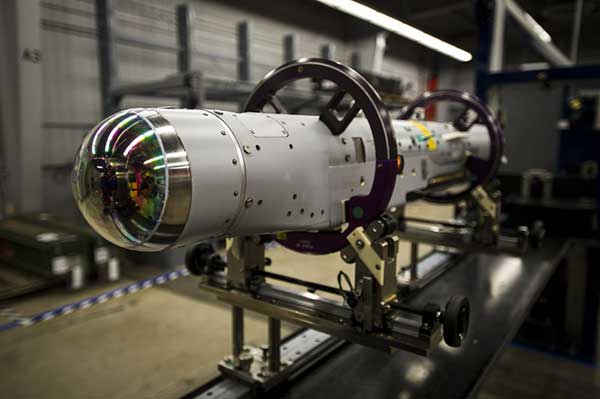
Raytheon Missiles & Defense, a Raytheon Technologies business, completed the first guided release of a StormBreaker smart weapon from an F/A-18E/F Super Hornet, which will become the second fighter jet to add the weapon when the program reaches initial operational capability later this year.
StormBreaker features a try-mode seeker that uses imaging infrared and millimeter wave radar in its normal mode. It can also deploy its semi-active laser or GPS guidance to hit targets.
During the U.S. Navy flight test, StormBreaker safely separated from the jet and successfully received guidance data from the plane, enabling it to be directed to its target while in flight, the company said.
“StormBreaker is the only weapon that enables pilots to hit moving targets during bad weather or if dust and smoke are in the area,” said Cristy Stagg, StormBreaker program director. “Super Hornet pilots will be able to use poor visibility to their advantage when StormBreaker integration is complete.”
Septentrio’s mosaic-T is built specifically for resilient and precise time and frequency synchronization under challenging conditions. (Photo: Septentrio)
Septentrio has launched the mosaic-T GPS/GNSS receiver module, built specifically for resilient and precise time and frequency synchronization under challenging conditions.
According to the company, its multi-frequency, multi-constellation GNSS technology — together with AIM+ Advanced Interference Mitigation algorithms — allows mosaic-T to achieve maximal availability even in the presence of GNSS jamming or spoofing. This compact surface-mount module is designed for automated assembly and high-volume production.
“We are excited to expand our mosaic GNSS module family with mosaic-T, which will provide critical infrastructure and mission-critical PNT applications with accurate, reliable and resilient timing solutions,” said Francois Freulon, head of product management at Septentrio.
Septentrio mosaic-T delivers timing with nanosecond-level accuracy and has additional inputs for an external high-accuracy clock, the company added.
Septentrio, headquartered in Leuven, Belgium, designs and manufactures multi-frequency multi-constellation GPS/GNSS positioning technology for demanding applications.
Altitude Angel and Inmarsat are collaborating to develop and deliver advanced flight tracking and management capability for UAVs.
According to the companies, they will build on Altitude Angel’s GuardianUTM platform to jointly develop a “pop-up UTM” capability that can be deployed anywhere it is required to manage beyond visual line of sight UAV flights, without the need for ground-based communications infrastructure. By utilizing Inmarsat’s global network of satellites and leveraging its experience in air traffic management communications, Altitude Angel’s pop-up UTM can be accessed rapidly and deployed worldwide, the companies added.
The pop-up UTM will be developed initially to address the unmanned traffic management needs of blue light emergency services and first responders who need aerial surveillance rapidly with little notice. The companies plan to release a commercial, industry-focused product soon after. Through this technology, emergency services will be able to remotely manage UAVs, increasing their range of safe operations in mixed airspace of manned and unmanned vehicles.
“The ability to almost instantly ‘pop-up’ safe, secure and fully operational UTM platforms in any environment, at any time, will give first responders, blue light services and aid organizations a valuable tool that could save countless lives,” said Phil Binks, head of air traffic management at Altitude Angel. “Altitude Angel and Inmarsat, in developing ‘pop-up UTM,’ will be able to bring connectivity, clarity and automated air traffic control services for UAVs in even the most challenging of circumstances.”
Altitude Angel is an aviation technology company delivering solutions which enable the safer integration and use of fully automated drones into airspace. Inmarsat is a British satellite telecommunications company, offering global mobile services.
On June 25, 1945, ION held its first organizational meeting on the Los Angeles Campus of the University of California.
According to ION, 55 people attended this meeting, where a “temporary” organization was established until a general meeting could take place in the fall when articles of incorporation could be drafted and adopted, council members elected and the vision for ION could begin to take shape.
The global impact of ION has been documented in its more than 2,600 technical papers that have been published in Navigation, the Journal of the Institute of Navigation. Navigation was first published in March 1946.
The Institute of Navigation is a non-profit professional organization advancing the art and science of positioning, navigation and timing.
San Francisco, captured by HERE’s 3D mapping technology. (Image: HERE)
In 1854, English physician John Snow mapped the London cholera epidemic to determine the exact location of a contaminated water pump on Broad Street, pioneering the use of location mapping and data to manage public health crises.
Today, governments and public health officials are utilizing location data to help fight the COVID-19 global pandemic. Location data and maps are at the frontlines to aid emergency responders and healthcare providers, while GIS professionals, data scientists and many others rely on maps and location data to allocate supplies, manpower and assets where they are needed most.
Data as a source of truth
Location data has been one of the most valuable tools to guide crisis response. By referencing professionally managed, comprehensive geospatial databases, public health officials are able to precisely locate key medical and emergency resources, including hospitals, medical centers, medical and emergency services, pharmacies, and food and water distribution centers.
For example, the HERE location platform continually validates the freshness and features of its map through thousands of data sources. This includes field-collected data, third-party data from government sources, and crowdsourced data from expert communities. Taken together, the process rapidly delivers clear, timely location information to end-users such as key medical stakeholders.
It is critical that all levels of government — local, state and federal — have access to these types of valuable datasets during times of emergency. In response to the pandemic, we have seen incredible agility from facilities that have been converted to provide critical medical services.
For example, the Javits Center in New York City has been used as a field hospital, a sports facility has been converted into a drive-through testing center, and schools are being used to distribute food. By tracking these updates, authorities have real-time awareness of these facilities and their availability to provide services.
Use Case #1
Social distancing efficacy
At this stage of the pandemic, the Federal Emergency Management Agency has tapped into location data to track the efficacy of social distancing policies and the spread of the virus. It’s valuable to map the virus’s spread for many reasons, but a few key reasons include:
Predicting the movement of COVID-19. By mapping the spread, we can proactively align the medical supply chain behind these predictions.
Understanding the effectiveness of social distancing. Social distancing is one of the most powerful ways to stop the spread of the virus. By tracking the efficacy of these measures and regulations and ensuring that citizens are complying with shelter in place, we’re able to predict how we are able to slow or flatten the spread.
Predicting the economic impact. As we consider reopening America for business, it’s important to understand where the virus is most prevalent, and the timeline for recovery.
Use Case #2
The strained medical supply chain
The coronavirus has caused strain across most industry supply chains, but most notably, the medical supply chain. Medical resources, including hospital beds, masks and life-saving ventilators have become scarce and unevenly distributed.
In times of crisis, with thousands of lives at stake and the potential for further economic fallout, it’s critical that public health officials are equipped with authoritative, comprehensive datasets to guide decision-making. When organizations are equipped with this valuable data, they can harness the power of location data for good and follow in the footsteps of the location data pioneer John Snow.
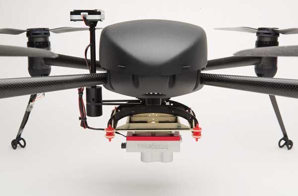
The Draganflyer Commander Ag-Pro Package. (Photo: Draganfly)
Draganfly has launched the Draganflyer Commander Ag-Pro Package, designed for the agricultural industry.
According to Draganfly, its Draganflyer Commander Ag-Pro Package includes everything needed to perform crop health assessment, irrigation monitoring and yield optimization.
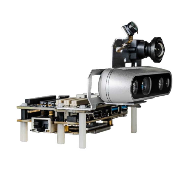
The Ag-Pro Package, which combines the MicaSense RedEdge-MX multispectral sensor and the Draganflyer Commander UAV, is suitable for projects requiring long flight times, a high level of data resolution and accuracy and data security, the companies added.
The Draganflyer Commander is an electric multirotor UAV built on Draganfly’s patented carbon fiber folding airframe. Its dual-battery system powers 35-minute flight times, and its automated flight planning tool allows users to quickly create coverage areas and flight plans.
The MicaSense RedEdge-MX multispectral sensor features five narrowband imagers that capture high-quality images that can produce maps for a multitude of agricultural uses. In addition, the sensor boasts two calibration methods that produce accurate data that can be compared across time, allowing for temporal analysis throughout the season and from year to year.
“We’re excited about bringing this affordable new multispectral option to market,” said Cory Baker, production manager at Draganfly. “We have been working with the MicaSense lineup of cameras for several years and have been very pleased with their seamless integration support and high-quality data outputs. Our skilled engineers can incorporate any of the powerful sensors from the MicaSense portfolio onto our UAVs.”
The Draganflyer Commander Ag-Pro Package features a secure controller, as well as a lightweight yet durable air frame.
NASA will be hosting the national space-based PNT advisory board meeting on July 1. The meeting will be held virtually, rather than in-person, 11 a.m. to 3 p.m. Eastern Time.
NASA sponsors the advisory board on behalf of the National Executive Committee for Space-Based PNT. Advisory board members are nominated by the agencies of the National Executive Committee and appointed by the NASA administrator.
According to NASA, this meeting will be formally called the “24th Interim Meeting” in preparation for the 25th meeting in the fall of 2020.
The meeting will cover a number of topics, including:
Updates on emerging U.S. PNT policies;
the status of GPS constellation services and modernization;
techniques to protect, toughen and augment to GPS/GNSS services for multiple user sectors;
alternative or complimentary PNT signals sources to GPS/GNSS signals in a stressed spectrum environment;
opportunities for enhancing the interoperability of GPS with other emerging international GNSS constellations; and
emerging trends and requirements for new PNT services in U.S. and international fora.
Those participating must use a touch-tone phone. Any interested person may dial the USA toll-free conference call number 1-844-467-4685 or toll number 1-720-259-7012, passcode 106724, to participate in this meeting by telephone.
For more information, contact James J. Miller, Designated Federal Officer, Human Exploration and Operations Mission Directorate, NASA Headquarters, Washington, DC 20546, (202) 358-4417, fax (202) 358-4297, or [email protected].
The Vanguard Cabinet is an advisory board made up of passionate, young geospatial professionals who strive to engage young practitioners, increase their numbers in the organization and better understand the concerns facing these future leaders of the geospatial community. The board consists of members that are 35 years of age or younger.
The cabinet’s mission is to collaborate with URISA’s board of directors and URISA committees in creating and promoting programs and policies that will benefit young professionals, as well as enhance overall innovation, collaboration, networking and professional development opportunities.
Cabinet members are selected through an application process, with a review by the URISA Leadership Development Committee. Those who apply must submit a letter of reference from a colleague, supervisor, mentor or instructor; a resumé; and a completed online application form.
The Qualcomm Robotics RB5 Development Kit (Photo: Qualcomm Technologies)
Qualcomm Technologies released the Qualcomm Robotics RB5 platform. The RB5, comprised of hardware, software and development tools, is designed for the consumer, enterprise, defense, industrial and professional service sectors.
According to the company, the platform’s Qualcomm QRB5165 processor offers a heterogeneous computing architecture, coupled with the fifth-generation Qualcomm AI Engine that delivers 15 tera operations per second of artificial intelligence (AI) performance for running complex AI and deep learning workloads. The processor also offers incredible machine learning inferencing at the edge under restricted power budgets using the new Qualcomm Hexagon Tensor Accelerator.
Technical features of the RB5 include heterogeneous computing capabilities, 5th generation Qualcomm AI engine, advanced imaging capability, security support and connectivity. Qualcomm’s Spectra 480 Image Signal Processor (ISP) captures fast, professional-quality photos and videos, and can process two gigapixels per second, the company said.
In addition, seven concurrent cameras facilitate simultaneous localization and mapping (SLAM), object detection and classification, autonomous navigation and path planning to perform tasks in indoor and outdoor settings.
With the Qualcomm Robotics RB5 platform and the Qualcomm QRB5165 processor, Qualcomm enables various design offerings including off-the-shelf system-on-module solutions and flexible chip-on-board designs, the company said. The solution is available in multiple options, including commercial and industrial-grade temperature ranges and an option for extended lifecycle until 2029.
“With the Qualcomm Robotics RB5 platform, Qualcomm Technologies will help accelerate growth in a wide array of robotics segments such as autonomous mobile robots, delivery, inspection, inventory, industrial, collaborative robots and unmanned aerial vehicles, enabling Industry 4.0 robotics use cases, and laying the foundation for the UAV Traffic Management space,” said Dev Singh, senior director, business development and head of autonomous robotics, drones and intelligent machines at Qualcomm.
Qualcomm also has entered into a strategic collaboration with TDK to further enhance the capabilities of the Qualcomm Robotics RB5 platform. Through the partnership, TDK added its latest sensor technologies for enhanced robotics applications as part of the Qualcomm Robotics RB5 platform.
The Qualcomm Robotics RB5 Development Kit
In addition, Qualcomm Robotics RB5 Development Kit ensure developers have the customization and flexibility they need to make their visions a commercial reality.
According to Qualcomm, the kit allows developers to have flexible software capabilities, with the platform offering support for Linux, Ubuntu and Robot Operating System 2.0, as well as pre-integrated drivers for various cameras, sensors and 5G connectivity. It also provides support for OpenCL, OpenGLES and OpenCV.
It also includes support for the Intel RealSense Depth Camera D435i and Panasonic TOF Camera to provide depth-sensing capabilities. TDK’s six-axis ICM-42688-P IMU, ICP-10111 barometric pressure and T5818 Digital bottom port microphone are integrated into the kit, as well.