“Recognizing the importance of driving engagement on future research, development and deployment of automated vehicles, we are confirming that all of the important content already planned for this year’s program will take place within a fully interactive virtual event platform,” organizers said.
The event will feature live sessions and networking, as well as a customizable schedule. In addition, keynote and plenary sessions will explore how society, technology and policy are preparing for and shaping the future of mobility.
The 1,174 page set of reports are comprehensive and document the first phase of what is intended as a multi-phase effort.
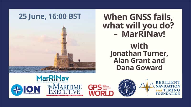
Graphic: RIN and RNTF
The webinar will present how maritime positioning requirements were systematically developed; an assessment of current and future positioning systems to deliver the required performance and integrity; rigorous gap analysis, showing where performance falls short, as well as options to solve these issues; and a roadmap of steps needed to take — and by whom — toward maritime resilient positioning.
Webinar speakers will include Jonathan Turner of the MarRINav project team, Alan Grant of the Royal Institute of Navigation and Dana Goward of the Resilient Navigation and Timing Foundation.
U.S. Air Force photo by Airman 1st Class Josie Kemp
The Swedish Defence Materiel Administration (FMV) signed a contract with navigation company iXblue for up to 172 FOG-based Quadrans gyrocompasses. The Quadrans navigation systems will be delivered over four years and will equip the Swedish Navy’s fleet of high speed crafts, mainly combat boats CB90.
“The FMV was seeking new maintenance-free and high-performance gyrocompasses for the retrofit of their fleet of high speed crafts,” said David Cunningham, commercial director at iXblue. “The CB90 vessels are indeed very fast boats and need the most reliable and accurate heading and attitude data to navigate safely. With our Marins Series Inertial Navigation Systems being already in service on the Gotland-class submarines and Koster Class MCMV’s, and our Quadrans gyrocompasses equipping other surface boats in the Swedish Navy fleet, the FMV was familiar with the high-performance delivered by our systems and knew the Quadrans met the specific requirements needed for the CB90.”
The Quadrans gyrocompasses are build around iXblue’s Fiber-Optic Gyroscope technology. According to the company, the gyrocompasses provide highly accurate heading and attitude data and are perfectly suited for high performance at high speeds and in challenging environments such as GNSS-denied settings.
In addition, the Quadrans Gyrocompasses are compact, lightweight and with low power consumption. They’re easy to install on small-sized crafts, while their open architecture guarantees seamless interfacing with all major GNSS systems and third-party navigation software, iXblue added.
Orolia has launched the virtual Orolia Air Show, which will take place June 23-26. The free event aims to connect the global aviation industry.
“As the aviation industry is deeply impacted in daily operations and trade shows are on hold, Orolia is highlighting the importance of aviation technologies with this global event,” the company said.
Attendees will have the opportunity to catch up on the latest industry updates and compliance requirements in a series of one-hour sessions.
Session topics will include the next generation emergency locator transmitters for commercial airlines; combat search-and-rescue beacons to support critical military missions; advanced GNSS anti-jamming and spoofing solutions for commercial and military critical infrastructure; and timing and synchronization embedded systems.
Founded in 2006 and headquartered in France, Orolia provides resilient positioning, navigation and timing solutions.
ION GNSS+ 2020 organizers have decided to host the event both in person and virtually. The ION GNSS+ 2020 virtual option will mirror the technical program being presented live, Sept. 21-25 in St. Louis, Missouri.
“This year, recognizing that some won’t be able to attend ION GNSS+ 2020 due to restrictions and with the goal of increasing global accessibility to everyone who wants to participate, the Institute of Navigation is excited to offer an ION GNSS+ 2020 virtual option,” the Institute of Navigation (ION) said.
Two session tracks will be live streamed, including the keynote plenary session, all panel sessions and mix of other sessions from various technical tracks. Virtual attendees also will be invited to participated in a moderated Q&A.
In addition, all technical sessions will be audio-recorded as they are taking place, with the slides uploaded to the ION GNSS+ 2020 virtual conference site. Virtual attendees will have the option of viewing all technical presentations on demand and on their own schedules, organizers added. The virtual conference option, however, does not include the pre-conference tutorials or pre-conference short courses.
All scheduled technical papers will be presented by authors in-person in St. Louis. The conference, however, will not include pre-recorded or off-site virtual presentations of technical papers.
ION will also provide an expanded online exhibitor profile that will allow exhibitors to upload a complete company profile with sales and contact information, company logos and company brochures. The online exhibitor profile also will include a link that allows attendees to email an exhibitor directly to ask questions or set up a phone or virtual appointment. Additionally, companies that purchased an island booth will be provided the opportunity to live stream an exhibitor demonstration during a scheduled conference break.
Virtual meeting attendance will be free for all first-time ION GNSS+ attendees. If an individual or organization requires assistance in order to participate in the show, ION is also offering a COVID-19 economic impact discount for the virtual option.
Orolia and Seven Solutions have partnered to deliver resilient, accurate, and stable time and frequency for global military, commercial and critical infrastructure applications.
According to the companies, the partnership will address the ultra-precise, resilient timing and frequency requirements of industries such as defense, aerospace, data centers, telecom, financial services, smart grids and other critical infrastructure.
Through the partnership, Orolia will offer a modular approach to resilient PNT, which includes a combination of GNSS signals protected with interference detection and mitigation technology, together with low Earth orbit secure alternative signals. The Orolia-Seven Solutions partnership also will offer terrestrial sub-nanosecond time distribution from distant and potentially redundant locations.
“This partnership is a key example of Orolia’s commitment to combining best-in-class technologies into more robust resilient PNT solutions for our customers,” said Orolia CEO Jean-Yves Courtois. “Those who require the most accurate, extremely precise time and frequency technology will now also benefit from an unprecedented level of resilience to protect critical PNT data sources, for more confidence and peace of mind.”
This new partnership between Seven Solutions and Orolia will facilitate global operations and naturally integrate with reliable time sources. Seven Solutions will focus on bringing the best-in-class time and frequency distribution, the companies said.
Bentley Systems‘ Year in Infrastructure 2020 conference will be hosted in a digital format.
The virtual Year in Infrastructure 2020 conference will provide complimentary access to a wide range of content relevant to infrastructure professionals in every role and at every phase of the infrastructure lifecycle, the company said.
Highlights of the 2020 conference will include the Year in Infrastructure 2020 awards finalists’ presentations, which will be held Oct. 5-16; the Year in Infrastructure 2020 Executive Perspectives, which will be held Oct. 20-21; a TwinTalks premier on Oct. 20; the Year in Infrastructure 2020 awards ceremony on Oct. 21; and Accelerate Sessions, which will take place Oct. 27 and beyond.
During the Executive Perspectives session, Bentley Systems CEO Greg Bentley will be joined joined by leading infrastructure executives for an interactive discussion on the resilience challenges they face and how to meet those challenges through digital advancement. In addition, Bentley Systems Founder and Chief Technology Officer Keith Bentley will discuss the company’s open strategy for digital twins.
The TwinTalks will feature leading industry figures as they discuss the implications of digital twins for digital cities, design and construction, digital plants, energy utilities, rail and transit, and roads and bridges.
The Accelerate sessions will feature Bentley product executives, including Dustin Parkman (project delivery), Robert Mankowski (digital cities), Ken Adamson (design integration), and Alan Kiraly (asset and network performance), as they and their leadership teams review the latest advancements in Bentley applications and cloud services.
Bentley Systems, headquartered in Exton, Pennsylvania, provides comprehensive software and digital twins services for advancing the design, construction and operations of infrastructure.
Version 8.5 of SimActive’s Correlator3D mapping software allows users to share and visualize projects in the cloud. (Photo: SimActive)
SimActive has launched version 8.5 of its Correlator3D mapping software. According to the company, this new version users to share and visualize projects in the cloud. More specifically, results can be exported to the cloud directly from the software interface, and shareable links are automatically created for online visualization.
Version 8.5 also features tools for the calibration and processing of multispectral imagery. Calibrated reflectance panels and sun sensors can be used to produce reflectance maps, with multispectral bands perfectly registered, the company said.
“Our software attracts a variety of clients, with a wide range of needs,” said Louis Simard, CTO at SimActive. “This new version brings advantages to customers having data exploitation requirements such as online viewing, and to users processing imagery from highly sophisticated sensors.”
SimActive, founded in 2003 and based in Montreal, Quebec, develops photogrammetry software. Its Correlator3D software, is a patented, end-to-end photogrammetry solution for the generation of high-quality geospatial data from satellite and aerial imagery.
Bentley Systems has acquired NoteVault, a voice-based field automation provider for construction management. This acquisition expands Bentley’s Synchro digital construction environment with mobile field applications to track and manage labor, materials and equipment.
According to Bentley Systems, these comprehensive offerings further extend the value of digital twins across construction management, enabling projects to combine immersive 4D models of the construction progress with detailed up-to-date reports on resource expenditures.
NoteVault’s SaaS solution is deployed via mobile devices, offering natural language automated speech-to-text, augmented with automated machine learning, and human transcription to ensure accuracy. Because NoteVault has been engineered specifically for construction site mobile field reporting, it recognizes construction-specific language for accurate transcription, and enables automated translation so non-native English speakers can submit daily reports more easily using their native language.
With NoteVault on their mobile devices, construction professionals can help synchronize status reporting effortlessly while saving time and money, reducing the risk of contractual disputes, Bentley Systems added.
“Digital twins continue to transform the way projects are delivered and operated,” said Dustin Parkman, vice president, project delivery, Bentley Systems. “Inherent in every digital twin is a stream of continuously updated data, and for construction, automating the semantic interpretation of field reports can now be one of the richest sources of live project information. With the addition of NoteVault’s market-leading resource tracking capabilities, the Synchro 4D construction environment delivers the most comprehensive construction digital twin solution available. We are excited to continue advancing the scope of construction digital twins.”
The 2020 Intergeo trade show will be hosted both in-person and virtually, said Intergeo organizer Christoph Hinte. The theme of the 2020 event will be “Geoinformation for a smarter world.”
“The hygiene and social distancing concept is currently being coordinated,” Hinte said. “In addition to the live event, this year is the first time we will also offer a virtual twin. Both the conference and the fair will be replicated. By hosting the fair in a virtual format, we expect to attract the same number of visitors as in previous years, if not more.”
Hinte made this announcement at the Intergeo Roundtable, an annual mid-year event for experts to discuss the latest industry trends.
During the roundtable, attendees discussed the latest industry trends. One trend mentioned in particular is the advancement of digitalization because of the COVID-19 pandemic. Trimble’s Janos Faust noticed that attitudes towards digitalization changed overnight after the breakout of the coronavirus pandemic, with people taking the digital transformation more seriously. Hexagon’s Michael Mudra also pointed out that anyone with round-the-clock access to automatically recorded, up-to-date and networked data that is evaluated using AI now has a clear advantage. Finally, Autodesk’s Ralf Mosler pointed out that companies are rapidly moving away from traditional work models and turning to technologies that completely reconnect BIM and GIS workflows.
Attendees also emphasized how the geo-IT industry can make a significant contribution to the climate crisis and current lack of resources. With regard to fleet management, up to 20% less fuel is being used and in Germany alone, precision farming methods are resulting in efficiency gains of 30%, Intergeo said in a press release. Whether it’s greater energy efficiency, enhanced energy utilization or even the simulation of different building methods, attendees agreed the industry is having a noticeable societal impact in both raw materials extraction and construction planning, Intergeo added.
Through the ION Online Job Board, ION corporate members can post job listings for free. For a limited time, non-ION corporate members can also post job listings for free. The job postings will expire automatically after 14, 30 or 60 days, depending on which expiration date the job poster chooses.
“To meet the burgeoning demand for a targeted talent pool specific to the PNT community, the new ION Online Job Board will help connect qualified job seekers with exciting and diverse employment opportunities for this niche audience, and in turn will help our corporate members continue to build talented teams to better ensure the success of their business,” said Lisa Beaty, executive director at ION.
The The Institute of Navigation is a not-for-profit professional organization dedicated to advancing the PNT industry.
This column will address why users will be required to perform GNSS occupations when submitting a leveling project to the National Geodetic Survey (NGS) after 2022. It will highlight a section of NGS Blueprint for 2022, Part 3, “Working in the Modernized NSRS,” that discusses the process of performing leveling projects after 2022. My October 2017 column briefly discussed NGS’ preliminary plans for incorporating geodetic leveling data into the North American-Pacific Geopotential Datum of 2022 (NAPGD2022) to establish orthometric heights consistent with GNSS-derived NAPGD2022 orthometric heights. It emphasized that after NAPGD2022 is established, the primary means for deriving orthometric heights on monuments will be using GNSS observations combined with the geoid model.
As a side note, NGS just released NOAA Technical Report NOS NGS 72–GEOID18, a report that provides a comprehensive explanation of the data and methods used to create the latest NGS hybrid geoid model. My February 2020 column provided an analysis of the differences between the latest published hybrid Geoid18 values provided on NGS’ Datasheet and the computed geoid height value using the published NAD 83 (2011) ellipsoid height and NAVD 88 orthometric height.
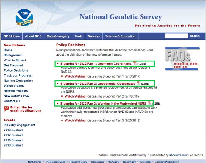
In support of the modernization of the National Spatial Reference System (NSRS), NGS has published three documents denoted as Blueprints for 2022 that describe the modernization of the NSRS (see the box titled “NSRS Modernization NGS Blueprint Documents”).
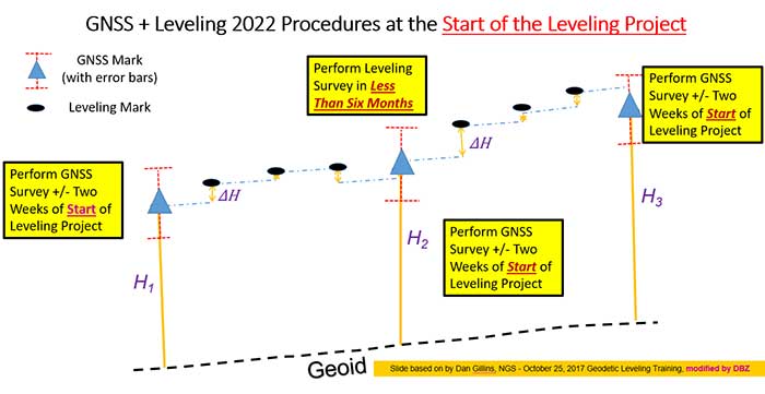
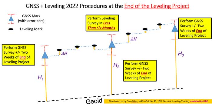
There are several sections in NGS Blueprint for 2022, Part 3, “Working in the Modernized NSRS,” that discuss the process of performing leveling projects after 2022. Something that will be new after 2022 is that NGS will require users to perform GNSS occupations in order to incorporate their leveling results into the new modernized NSRS.
NGS realizes that in the immediate future GNSS will not replace geodetic leveling for determining the most accurate local orthometric height differences. NGS’ plans include preparing a new leveling manual that will explicitly explain how to work in the modernized NSRS. Some of the new surveying procedures are described in Section 2.10 of Blueprint part 3. In section 2.10, NGS states that there will be substantial changes in how they process and serve up survey data, and that there will be some new ways of executing surveys. This column will focus on sections “2.10.2 Leveling” and “2.11.5 Leveling on Passive Marks” that discuss the new procedures for executing leveling surveys in the modernized NSRS. One major change is that leveling surveys will require Global Navigation Satellite System (GNSS) occupations to ensure orthometric heights computed in leveling surveys are up-to-date and are connected to the NSRS through the NOAA CORS Network. After the modernization of the NSRS in 2022, the NOAA CORS Network will be the primary access to the NSRS. This means leveling and classical surveys will require GNSS surveys to be part of the project. NGS’ plans include creating an OPUS option for processing all types of surveys. Users will be able, within OPUS, to adjust their projects using any mix of CORS data and passive control. Saying that, these same projects, on submission, will be deconstructed at NGS and reduced to the raw observations, then adjusted solely to the NOAA CORS Network to determine Final Discrete coordinates every GPS Month. The GPS Month concept may be new to some users. Blueprint Part 3 describes the concept in section “2.11.3 GNSS on Passive Marks.” The basic concept of a GPS Month is that it is four consecutive GPS weeks, with the first week in the GPS month having a GPS week number that is a multiple of four (see box titled “Definition of a GPS Month”).
Definition of a GPS Month
GPS month: Four consecutive GPS weeks, with the first week in the GPS month having a GPS week number that is a multiple of 4.
In this fashion, NGS defines:
GPS month 0 = GPS weeks 0, 1, 2, and 3 (1/6/1980 through 2/2/1980)
GPS month 1 = GPS weeks 4, 5, 6, and 7 (2/3/1980 through 3/1/1980)
GPS month 2 = GPS weeks 8, 9, 10, and 11 (3/2/1980 through 3/29/1980)
…
GPS month 513 = GPS weeks 2052, 2053, 2054, and 2055 (5/5/2019 through 6/1/2019)
etc.
So, what does this really mean to the user when performing a leveling project in 2022? For a leveling project to be processed using NGS software and/or submitted to NGS for inclusion into the NSRS database, the user must follow specific rules.
The following is from Blueprint, Part 3, section “2.10.2 Leveling:”
“As GNSS occupations are required for geodetic leveling, the rules for how many and how frequently will be:
For a leveling project to be processed using NGS software and/or submitted to NGS for inclusion into the NSRS database, its field observations should not span more than one year. Longer projects should be broken into sub-projects of less than one year.
A minimum of three “primary control marks” must be in the level network for every project.
More primary control marks should be added so there is never more than a 30-kilometer linear distance between marks in the entire network.
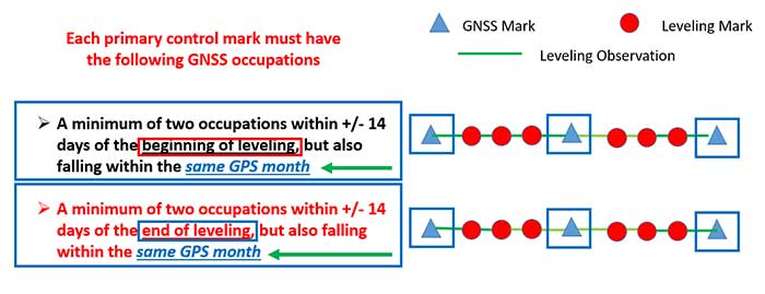
Each primary control mark must have the following GNSS occupations (details on using GNSS occupations to work in the NSRS will be found in the update to NGS 58):
A minimum of two occupations within +/- 14 days of the beginning of leveling, but also falling within the same GPS month and whose local start times are separated by between 3 and 21 hours.
It is preferable, but not required, that all occupations on any primary control mark occur within the same GPS month as those of all other primary control marks.
A minimum of two occupations within +/- 14 days of the end of leveling, but also falling within the same GPS month and whose local start times are separated by between 3 and 21 hours.
It is preferable, but not required, that all occupations on any primary control mark occur within the same GPS month as those of all other primary control marks.
All projects exceeding six months must have a third set of GNSS occupations on all primary control marks some time near the middle of the project, without a rigorous rule as to when. They must follow the “minimum of two occupations” rule as per above, and each mark’s occupation is required to fall in the same GPS month, with a preference that all primary control marks are occupied in the same GPS month.”
The box titled “GNSS Procedures for Leveling Projects” highlights the GNSS rules that need to be adhered to when performing leveling projects in 2022.
GNSS procedures for leveling projects
For the Immediate Years Following 2022, NGS Will Require That all Leveling Projects Turned in Have GNSS on Primary Control
Minimum of 3 Points with a Maximum Spacing of 30 km
At Least Two Occupations of Each GNSS Primary Control:
+/- 14 days of Beginning of Leveling
Within the Same GPS Month
+/- 14 days of Ending of Leveling
Within the Same GPS Month
Diagram: David B. Zilkoski
The boxes titled “GNSS + Leveling 2022 Procedures at the Start of the Leveling Project” and “GNSS + Leveling 2022 Procedures at the End of the Leveling Project” provide conceptual diagrams that illustrate what this means to a typical leveling project.
Diagram based on information from Dan Gillins, NGS, and modified by David B. ZilkoskiDiagram based on information from Dan Gillins, NGS, and modified by David B. Zilkoski
So, why is NGS requiring users to perform GNSS observations in support of leveling project. Leveling is a differential measurement technique; it generates relative height differences not absolute heights. In NGS’ modernized, time-dependent 2022 NSRS, the absolute height will be provided by up-to-date GNSS data; and the accurate relative height differences between leveling marks will be provided by the leveling data. (See box titled “Why NGS Requires GNSS Occupations on Primary Marks.”)
Why NGS requires GNSS occupations on primary marks
The Connection to NAPGD2022 is Obtained Through GNSS and a High-Accuracy Geoid Model
Network Accuracy
The Accuracy of the Height Differences are Provided Through the Leveling Data
Local Accuracy
Combining the leveling and GNSS increases the redundancy in a survey network
NGS is developing models and tools to facilitate the incorporation of leveling survey data and adjustment results into the new modernized NSRS in 2022. Blueprint, Part 3, section “2.13.3 OPUS for Leveling,” describes NGS plans to support leveling surveys through the use of the OPUS web tool. The box titled “OPUS for Leveling” outlines how NGS will modify the OPUS web tool to support leveling surveys.
OPUS for leveling
Support for leveling surveys will follow many of the best aspects of OPUS
Uploading and processing digital data files
Using a web-based graphical interface
Submitting data to NGS
Leveling is a differential measurement technique
It generates relative height differences not absolute heights
For users who need absolute heights in the NSRS
OPUS will support a mix of GNSS and leveling in a single project
NOTE: NGS will require a GNSS survey to be performed at specific times before and after leveling surveys in order for the data to be submitted for inclusion in the modernized NSRS after 2022.
NOTE: Leveling surveys longer than one year must be broken up into multiple projects. Leveling surveys between 6 and 12 months in duration require a third, intermediary GNSS data collection.
This column highlighted that in the modernized NSRS the only way to get “into the datum” will be through a GNSS survey. It noted that leveling projects generate relative height differences not absolute heights. In NGS’ new modernized, time-dependent NSRS, the absolute height will be provided by up-to-date GNSS data; and the relative height differences between leveling marks will be provided by the leveling data. A major requirement will be that users must collect GNSS data both at the beginning and at the end of a leveling survey project. Leveling survey projects that take longer than one year to complete must be broken up into multiple projects. NGS is developing model and tools to facilitate incorporating all types of survey data into the new NSRS. I would encourage all readers to read NGS’ Blueprint for 2022 documents to obtain a better understanding of the new, modernized NSRS.