L3Harris has demonstrated a positioning, navigation and timing (PNT) solution for the U.S. Space Force’s Space Systems Command that is adaptable across platforms, fully reprogrammable on orbit and scalable to support more signals and increased power as PNT threats evolve. According to L3Harris, the solution is designed to provide the Space Force with the flexibility to deploy smaller, multi-launch-capable satellites, thereby strengthening or diversifying its satellite constellation.
During a two-day design concept review, L3Harris presented a resilient-GPS (R-GPS) prototype that exceeded current requirements, highlighting its potential to accelerate the Space Force’s roadmap for a stronger, more adaptable PNT infrastructure. Using the Navigation Technology Satellite-3 reprogrammable payload and NSA-certified cryptography, the company simulated the operation of an R-GPS satellite transmitting navigation signals. These signals were successfully acquired and tracked by monitoring stations, military receivers and commercial equipment, demonstrating that R-GPS technology can be seamlessly integrated into the existing GPS framework.
“Our team transmitted, tested and validated a core set of R-GPS signals across the entire enterprise to demonstrate a fully reprogrammable, resilient PNT solution for the Department of Defense,” said Ed Zoiss, president of Space and Airborne Systems at L3Harris. “We leveraged best-in-class commercial technology and the government’s investment in NTS-3 PNT technologies.”
L3Harris followed a “prototyping with purpose” approach that showcased maturity far beyond a traditional Preliminary Design Review, resulting in a low-risk, achievable plan for the future development phases of the R-GPS program. The L3Harris R-GPS design includes capabilities aligned to future Lite Evolving Augmented Proliferation, providing an opportunity for roadmap acceleration and reduction in lifecycle costs.
“Our approach supports satellite design verification, proves compatibility with the Control Segment and user equipment, and enables early integration opportunities,” Zoiss said. “After more than five decades in the field, we understand the challenges in aligning the Space, Control and User segments of the GPS enterprise, so we used a holistic, unified approach.”
The Design Concept Review demonstrated how the L3Harris R-GPS satellite can minimize impact on existing control systems while maintaining backward compatibility with current and future user equipment. In 2024, L3Harris was selected to design concepts for Phase 0 of the R-GPS program through the Space Enterprise Consortium, which the National Security Technology Accelerator manages. The agile R-GPS satellite program aims to reduce costs by launching eight smaller, more advanced space vehicles simultaneously, allowing the United States to quickly modernize GPS.
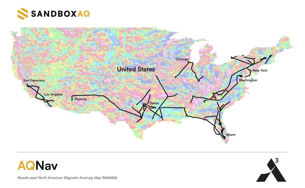
As GNSS denial, jamming and spoofing threaten aviation safety, SandboxAQ and Acubed, the Silicon Valley innovation center for Airbus, have released real-world test results from a five-month, nationwide projectdesigned to test the accuracy of AQNav.
AQNav is an artificial intelligence-driven magnetic navigation (MagNav) system. AQNav uses advanced quantum magnometers to read Earth’s crustal magnetic anomalies, like a geoohysical fingerprint, then employs large quantitative models (LQMs) to filter out electromagnetic interference and precisely determine an aircraft’s position without relying on satellite signals.
These new results come from a nationwide initiative with Acubed’s Flight Lab to test the navigational accuracy of AQNav. Meeting the aviation industry’s Required Navigation Performance (RNP) standards is necessary for deploying the system on military, commercial and civilian aircraft.
AQNav’s performance was tested under various opertional scenarios and demonstrated advanced precision, accoding to SandboxAQ. The goal was to determine whether magnetic anomaly-aided navigation could broadly meet navigation requirements for commercial aircraft. AQNav’s capabilities exceeded the accuracy required for en route travel between airports — even on the program’s longest flight.
Accuracy
RNP Standard
Required Accuracy (meters)
% of Flight Time Met
RNP 0.3
550
64%
RNP 1
1,852
95%
RNP 2
3,704
100%
To demonstrate how the real-time capable system would operate in real-world conditions, flight data was collected, reprocessed, and streamed in real time to produce statistical insights, offering representative capability data for joint team evaluation.
Real-World Impact
SandboxAQ and Acubed focused on designing tests to mirror authentic, real-world aviation scenarios. For example:
Standard aircraft platform: AQNav was tested using publicly available magnetic maps aboard a standard Beechcraft Baron 58 – rather than a compensated geosurvey platform. This aircraft was modified only to accommodate the additional AQNav instrumentation – no extensive electromagnetic shielding or specialized noise isolation were used. All sensors were positioned inside the aircraft, powered by AQNav’s software to deliver a clean magnetic signal.
Use of apublicly available map. For all flights, AQNav researchers used the publicly available North American Magnetic Anomaly Map (NAMAM), which covers the U.S., Canada, parts of Mexico and surrounding oceanic regions.
Unfiltered flight paths: Flight operations spanned diverse, operationally relevant routes between 200 airports across the entire continental U.S. (Fig. 1), without filtering based on magnetic anomaly strength, magnetic map quality, or favorable geomagnetic gradients. More than 150 hours of flight data was collected.
Diverse geophysical environments: Data was collected over a full range of conditions, from magnetically-rich mountains to sparsely featured plains, reflecting real-world geographies where aircraft might operate without GNSS.
True operational noise: Onboard, AQNav successfully filtered out the real-world interference generated by the aircraft, including electromagnetic, vibrational and other airframe-induced noise.
Fig. 1: Acubed Flights with AQNav (Credit: AQNav
Elijha Williams, AQNav’s technical engagement manager, said: “Our campaign was not about demonstrating proof of concept performance under ideal conditions, it was about proving AQNav’s viability under the noisy, messy, and unpredictable environments real pilots face every day.”
During test flights exceeding two hours, AQNav outperformed the Inertial Navigation System (INS) without GNSS 100% of the time. During a one-hour flight over the challenging mountainous and forested terrain of California, AQNav achieved its best-observed accuracy of less than 74 meters, or roughly two-thirds the length of an American football field.
Precision, Scale and Autonomy for the Future
This campaign marks a significant step toward widespread adoption of AQNav in aviation. By consistently maintaining accuracy in an uncontrolled, national testbed, SandboxAQ demonstrated AQNav’s operational robustness under real-world conditions.
Andrew Sosa Sosanya, a quantum navigation machine learning engineer at SandboxAQ, highlighted the impact of the data collected: “Thanks to Acubed, the U.S. Air Force, and other partners, we’ve accumulated a highly relevant MagNav dataset. This creates a flywheel effect—the more data we gather, the faster we can improve model accuracy across diverse mission profiles.”
AQNav is also undergoing testing with Boeing, a U.S.-allied air force, and as part of NATO’s 2025 DIANA cohort.
The U.S. Space Force’s Space Operations Command has accepted a modernized operating system for GPS, designed to maintain the resiliency of the constellation and enhance positioning, navigation and timing (PNT) services to meet evolving user demands.
The GPS Next Generation Operational Control System (OCX) upgrade is part of a broader set of Space Systems Command acquisition programs designed to deliver a range of modernized capabilities across the GPS III enterprise. In addition to OCX, these programs include the GPS III/IIIF satellite vehicles and Military GPS User Equipment.
The modernization effort is expected to improve signal access in electronically contested environments, increase the system’s ability to detect failures, enhance position and time transfer accuracy, and strengthen the integrity and uninterrupted availability of the Military Code.
“One of our missions is to deliver sustained, reliable GPS capabilities to America’s warfighters, our allies, and civilian users,” said Cordell DeLaPena, program executive officer for military communications and PNT at Space Systems Command. “The current enterprise modernization efforts underway give users confidence that GPS will continue to provide worldwide premier PNT service.”
Mission Delta 31, in partnership with Space Systems Command, developed a systematic process involving transition exercises, rehearsals and constellation transfer trials to verify the system’s integrity and capability prior to full transfer, according to Col. Stephen Hobbs, commander of Mission Delta 31. Hobbs added that risk reduction activities are underway to demonstrate OCX’s ability to integrate with existing, on-orbit GPS satellites.
Raytheon initiated the delivery of OCX to the U.S. government with the submission of the Department of Defense Form 250 on July 1, 2025. Following acceptance, Mission Delta 31 will continue integrated systems testing, operational readiness exercises and preparations for the eventual transfer of the GPS constellation to the new system.
“Testing and transition events will continue until the system is ready to transfer to operations, which is expected in late 2025,” said Hobbs. “Technology in space is advancing at lightning speed, with many new players from around the world. To continue providing reliable GPS for everyone, from your smartphone map to critical military operations, innovation is vital. Modernizing GPS is key in maintaining this essential service and remaining a leader in Space.”
CHC Navigation (CHCNAV) has released the AU20 MMS, a vehicle-mounted mobile mapping system designed for accurate and efficient collection of 3D spatial data. The system combines high-performance lidar technology, versatile sensor support and intelligent data processing to provide a practical and flexible solution for professionals in road surveying, asset management and infrastructure documentation.
The AU20 MMS features a sophisticated lidar system that uses fourth-generation real-time waveform processing technology. It achieves a scan rate of 2 million points per second and 200 revolutions per second, producing point cloud data with 5 mm accuracy and 3 mm precision. This level of detail allows for the identification of fine surface characteristics and features, supporting comprehensive asset inventories and condition assessments. The system’s long-range, multi-cycle laser technology enables high-density data capture up to 250 m in vehicle-mounted applications.
Built on the adaptable AP7 vehicle platform, the AU20 MMS supports a dual laser scanner setup to increase data density. The platform includes a 45° scanning angle to reduce data shadows and improve detection of vertical structures and road signage. The AP7’s built-in processor allows integration of up to eight external sensors, including specialized pavement detection cameras and panoramic cameras such as the Ladybug5+ and Ladybug6, giving users flexibility in data acquisition strategies.
The AU20 MMS uses artificial intelligence-based algorithms to refine data quality and streamline processing. AI-driven vehicle motion trajectory adjustment automatically identifies control points, correcting point cloud inaccuracies to within two centimeters to meet highway-grade survey requirements. AI-powered panoramic coloring achieves more than 95 percent accuracy in recognizing and handling vehicles and pedestrians, resulting in clean, interference-minimized colorized point clouds with efficient one-click optimization.
CHCNAV’s software suite, CoPre and CoProcess, streamlines workflows through intelligent automation. CoPre optimizes data preprocessing, allowing real-time adjustments to point clouds and imagery while minimizing manual intervention. CoProcess uses AI algorithms for feature extraction, including road assets, terrain models and building structures, to accelerate project delivery.
One of the most persistent sources of GNSS error — ionospheric delay — has been challenging to correct in real time, especially for mass-market devices. While dual-frequency receivers and commercial correction services can mostly mitigate this issue, they remain too costly and impractical for the billions of smartphones and IoT devices that rely on single-frequency GNSS. Even for dual-frequency systems, the commonly used ionosphere-free linear combination amplifies multipath and receiver errors and reduces data redundancy — yielding only two usable combinations from four original measurements.
This landscape may be shifting with the introduction of GloTEC, a real-time global Total Electron Content (TEC) map from NOAA’s Space Weather Prediction Center (SWPC), released in February 2025. GloTEC assimilates both ground- and space-based observations to provide real-time global ionospheric corrections without relying on error-prone linear combinations.
Unlike coarse models such as the broadcast Klobuchar algorithm or forecast-only products such as the predicted IGS Global Ionosphere Maps, GloTEC updates every 10 minutes using real-time measurements. This high refresh rate establishes a new benchmark for open-access ionospheric nowcasting in GNSS applications.
Originally designed to monitor and mitigate space weather impacts on aviation and communications, GloTEC may also deliver a broader benefit: enabling precise, scalable GNSS corrections for low-cost, single-frequency devices, making high-accuracy positioning more accessible and democratic.
Why Nowcasting Matters for GNSS
The GNSS community has long had to choose between accuracy and latency. Predictive models, such as those from NASA CEDIS or CODETEC, can offer reasonable approximations but may fall short when real-time corrections are required, particularly in the context of navigation, asset tracking or autonomous systems.
Post-processed products (such as rapid/final IGS GIMs) provide excellent fidelity but are typically delayed by hours, days, or even weeks. This makes them useful for research or auditing, but not for real-time navigation needs.
Commercial correction services, such as Trimble RTX and Hexagon’s TerraStar, have filled the gap for high-value applications. These systems interpolate ionospheric corrections in real time, but at a significant cost and they typically require specialized GNSS receivers.
GloTEC bridges this gap by delivering a publicly accessible, high-refresh ionospheric product that can support near real-time corrections. Updated every 10 minutes with a 2.5° latitude and 5° longitude spatial resolution, GloTEC represents a major step forward for public sector GNSS capability, particularly in contexts where accuracy, reliability and scale are all crucial. The data has also been supporting the United States Space Force and is accessible through their Unified Data Library (UDL).
Technical Approach: Adapting GloTEC for Practical Use
While the potential of GloTEC is exciting, turning it into usable corrections for consumer-grade devices isn’t straightforward. TEC maps represent volumetric electron density, while most mass-market GNSS chipsets, especially in smartphones, expect simplified models, such as the eight-parameter Klobuchar model broadcast by GPS satellites. GloTEC is a three-dimensional data assimilation system that uses a Gauss-Markov Kalman Filter to estimate electron density in the ionosphere. It ingests slant TEC measurements from ground-based GNSS receivers and space-based radio occultation data, using the IRI-2016 model as its background state.
To bridge this mismatch, Zephr’s team has been exploring regional fitting techniques, whereby a local subset of GloTEC data is used to generate custom Klobuchar coefficients. These can be transmitted to devices via standardized protocols, such as the LTE Positioning Protocol (LPP), enabling improved ionospheric delay estimation with minimal changes to device-side computation. Even with a regionalized Klobuchar fit and LPP encoding, there is still the problem of accessing the GNSS chip to apply the corrections. To solve this problem, Zephr has created a virtualized positioning engine that takes the raw GNSS measurements from the chip and provides a purely software-based solver. This approach allows the team to implement a variety of more advanced positioning techniques using commodity hardware such as smartphones.
Field Testing: A Quantitative Step Forward
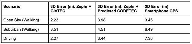
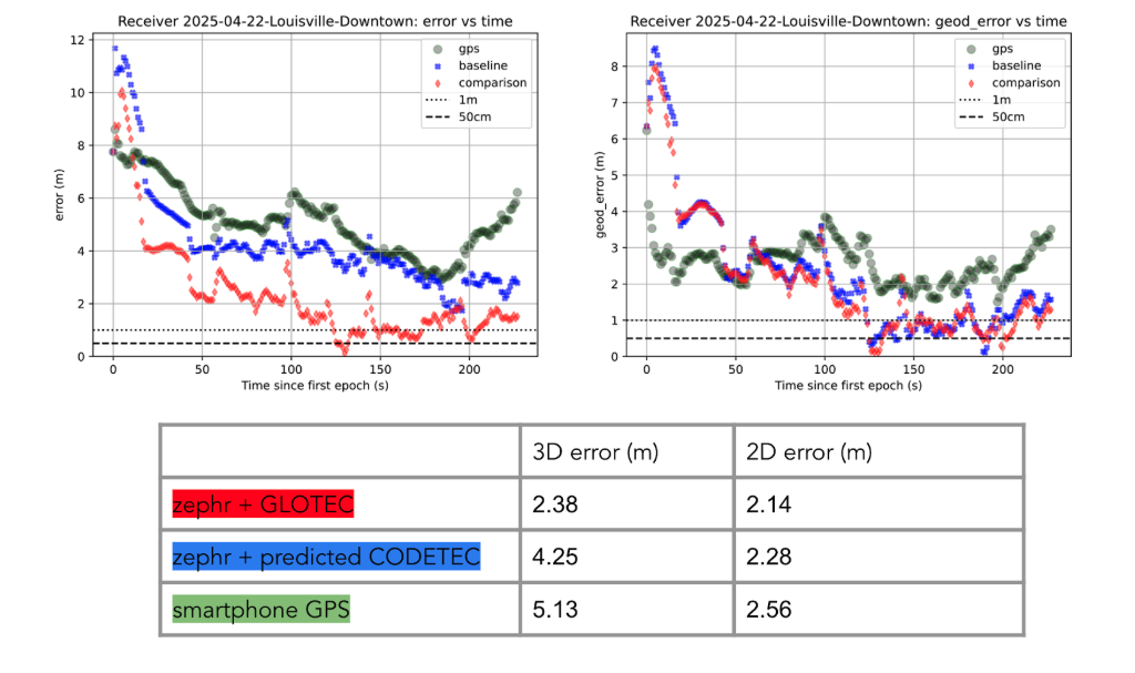
To evaluate the efficacy of GloTEC in improving GNSS accuracy, engineers at Zephr used the virtualized positioning engine to conduct 51 real-world campaigns across various conditions – including urban, suburban, static, walking, and driving – using a Pixel 8 smartphone and an RTK unit for ground truth.
The results were promising, as shown in Figure 1:
Figure 1: GloTEC vs. CODETEC vs. Android Native across multiple scenarios. (All figures provided by author)
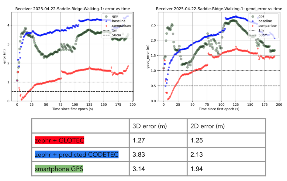
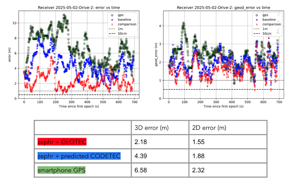
We can break down these results using detailed graphs for each scenario as examples. This will provide a more in-depth look at the positioning for specific traces through the outlined scenarios in Figure 2, Figure 3 and Figure 4:
Figure 2: GloTEC vs. CODETEC vs. Android Native for an open sky walking scenario
Figure 3: GloTEC vs. CODETEC vs. Android Native for a suburban downtown walking scenario.Figure 4: GloTEC vs. CODETEC vs. Android Native for a mixed sky driving test.
Across all categories, the GloTEC-based regional fitting approach significantly outperformed both the default GNSS solution (which uses broadcast data plus a Klobuchar mode) and the competing IGS products. Accuracy improved by up to 69% in driving scenarios and 46% in walking scenarios, compared to standard smartphone GPS.
While the Pixel 8 used in testing supports dual-frequency GNSS, smartphones face several practical limitations that hinder effective use of ionosphere-free dual-frequency combinations. These include limited signal availability (due to antenna constraints, L1/L5 support gaps, and partial constellation coverage), elevated multipath and noise (especially from omnidirectional antennas in dynamic conditions), and unstable clock biases that complicate error modeling. In fact, iono-free combinations can amplify multipath effects, potentially degrading accuracy in some conditions.
Despite these constraints, the results show that meaningful improvements in positioning are possible using a software-based approach with publicly available corrections. GloTEC, when paired with cooperative or cloud-based GNSS engines, offers a substantial step forward without requiring expensive commercial correction services or specialized hardware.
Broader Implications and Next Steps
While these results are promising, several challenges remain before GloTEC-based corrections can be broadly deployed:
Connectivity Requirements: Real-time access to GloTEC requires periodic downloads over cellular or Wi-Fi connections, raising questions about reliability in low-bandwidth or disconnected environments.
Global Calibration: The accuracy of regional fitting depends on local coverage density and VTEC variability. Further tuning may be needed in equatorial or polar regions, where ionospheric behavior is more volatile.
Nevertheless, the availability of GloTEC marks a significant milestone. For the first time, a free, real-time, high-resolution ionospheric correction product is accessible to developers, researchers, and engineers seeking to improve GNSS accuracy at scale. NOAA SWPC has plans to integrate more low-latency space-based and ground-based data into GloTEC in the near future. The new version of the model outputs will be released to the public once the results are validated. As techniques for applying it to mobile and IoT devices mature, the GNSS community may see a broad shift toward more precise, resilient, and cost-effective positioning systems.
GloTEC may have been designed to help forecasters monitor the response of the ionosphere due to space weather events, but its potential to provide an advanced tool for positioning on Earth is just beginning to be understood. In a world where nearly every mobile application depends on location, and where the cost of poor accuracy is rising (from package delivery failures to navigation errors), this kind of public infrastructure is invaluable.
Researchers and industry developers alike should explore how this NOAA capability can be integrated into their positioning systems. If properly supported, GloTEC could become one of the most impactful GNSS innovations of the decade.
Septentrio, part of Hexagon, has added the onocoy GNSS correction service to its Agnostic Corrections Partner Program. The program is designed to give users the ability to select from multiple high-accuracy correction services, supporting a range of application needs and geographic requirements.
The onocoy service operates as a decentralized, crowdfunded RTK network, providing reliable and cost-effective high-accuracy positioning. This approach is intended to benefit sectors such as agriculture, mining, drone operations, robotics, autonomous vehicles, geodesy and more.
Onocoy operates a community-driven GNSS RTK network powered by Web3 and blockchain technology, to offer secure, transparent and efficient data sharing and transactions, according to the company. Although privately operated, this network actively monitors its base stations to maintain service reliability and quality. Onocoy is joining Septentrio’s Agnostic Corrections Partner Program, which already includes several leading correction services such as GEODNET‘s RTK Service and Swift Navigation’s Skylark Precise Positioning Service.
VertiGIS has introduced VertiGIS Neo, a secure, cloud-based platform designed to improve sector-specific workflows through artificial intelligence (AI).
According to the company, VertiGIS Neo aims to accelerate business operations, streamline problem-solving and boost productivity by delivering modern web and mobile user experiences across its suite of solutions, including VertiGIS Studio, VertiGIS FM, VertiGIS Networks and VertiGIS ConnectMaster.
The platform incorporates embedded AI to drive innovation for both end users and application development teams. VertiGIS Neo enhances workflow processes in three key areas:
End-user assistants: AI-powered assistants and a low-code/no-code interface help users complete tasks more efficiently in web and mobile applications.
Application builder productivity: AI co-pilots enable administrators to configure and customize solutions with less effort.
Process transformation: AI capabilities fundamentally change how work is performed, from field operations to back-office tasks.
Flexible Cloud Deployments
VertiGIS Neo is built on a cloud-first infrastructure that supports fully managed, private, or hybrid cloud environments, offering operational flexibility, scalability and enhanced security. The platform supports rapid deployment within CI/CD pipelines and provides predictable pricing models for customers.
VertiGIS Neo offers three deployment options:
Cloud managed services: Complete cloud-based solution delivery, including data, infrastructure and applications.
Private cloud: Turnkey deployment into customer environments using prescribed hardware and containers.
Hybrid cloud: Multi-tenant and single-tenant SaaS applications accessing customer data within their environment.
Industry Solutions
VertiGIS Neo is designed to address business challenges across several sectors:
Utilities: Enables customers to model physical network infrastructure as digital twins and manage millions of service points, supporting the entire asset lifecycle from planning to decommissioning.
Telecommunications: Streamlines management of FTTx services and oversees both physical assets and logical circuits for communications providers.
Local Government: Helps build transparent, engaged and sustainable smart cities, improving engagement for both citizens and staff.
Enterprise: Integrates IoT and AI for real-time intelligence, remote sensing and asset tracking, fostering innovation in the private sector.
VertiGIS Neo’s features include dynamic attribute analysis with natural language queries, voice-to-prompt interfaces for map queries and automatic asset inspection and damage assessment using image recognition. The platform also allows users to create intelligent workflows from text prompts and automates the digitization of paper forms into digital records.
On June 13, following reports of Israeli airstrikes on Iran, interference rates in the Strait of Hormuz spiked. GPSJam.org, a service that tracks satellite signal interference, now reports medium-level disruption (between 2% and 10%) across the Gulf region. This is no isolated blip, but part of a pattern: electronic warfare is increasing in global hotspots. It’s also a warning.
Modern warfare is no longer about guns and bombs. Jamming, spoofing and using ever-more sophisticated cybertricks to disrupt GNSS are now regular tactics used to sow disorder. They are cheap, deniable, and often highly effective. But they also expose a dangerous weakness in how we navigate, communicate, and coordinate. If GPS is the backbone of global positioning, we are learning just how brittle it can be.
Strait of Hormuz Under Threat
The Strait of Hormuz is a narrow channel through which around one-fifth of the world’s oil passes, and here, ships are now at risk not only from pirates and mines, but from corrupted satellite signals. Spoofers can broadcast false GPS positions to nearby vessels. In recent years, we have seen ships appear to sail across runways, airports, and deserts, thanks to malicious signal interference. In aviation, spoofed or jammed GNSS signals have led to aircraft turning around mid-air or being diverted. These are real and growing threats.
As someone who has worked in naval intelligence and the defense industry for decades, I have seen how quickly technology evolves, and how slow we can be to protect our own systems. But there are solutions to the problem I’ve described. One is laser-based optical communications.
The Need for Resilient PNT
Laser communication is very difficult to jam or spoof. Unlike the low-power radio frequencies used by GPS, a laser beam is narrow, focused, and nearly impossible to intercept without being detected. And because lasercom is optical, not radio, it isn’t vulnerable to the same types of interference. That makes laser communication ideal for high-security communications and low latency support in contested environments.
Optical ground station networks, when paired with optical satellite links, also offer vastly higher data transfer capacity than conventional RF systems. Optical links can now carry 1,000 times more data than their RF counterparts. At a time when threats are growing quickly and data needs are exploding, that kind of capacity is essential.
This will make you wonder why lasercom isn’t more widely used. The answer is that only in recent years has it become mature and able to be deployed rapidly. Systems that once seemed exotic or experimental are now proven, reliable, and ready to scale. Many space agencies and defense organizations, including the US Department of Defense and NATO, are investing in them.
To be clear, optical comms will not replace GPS or radio. But they can supplement and support it, especially in high-risk areas where GNSS is under attack. Just as militaries don’t rely on one radar or one radio channel, governments shouldn’t rely on a single source of truth for navigation and timing.
Escalating Threats to Critical Infrastructure
When you depend on precise location data for everything from logistics to drone strikes to the safe passage of oil tankers, the idea that one bad actor with a spoofer can throw you off course is a real concern. When the threat can be made a reality without firing a shot, you can be sure it will be used more and more often.
Just as satellites offer a way to monitor subsea cable sabotage, they also offer a chance to future-proof our navigation and communication networks. The same technology that is being used to track ships and sense underwater disruptions can be adapted to create robust, high-speed, interference-proof backup channels. Governments that invest in this infrastructure now will be in a far stronger position to deter attacks, respond quickly, and maintain operational clarity when others cannot. We wish it were otherwise, but the world is becoming more dangerous, and attacks will accordingly become more common.
If the last year has taught us anything, it’s that infrastructure is no longer neutral. It’s considered a legitimate target, particularly by those whose aim is to create confusion and disorder. GNSS isn’t immune to this trend. In fact, because of it’s importance, it’s a prime target. We have to stop assuming that what worked in peacetime will work at a time of conflict. That, sadly, is the reality of this moment.
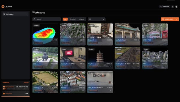
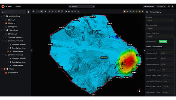
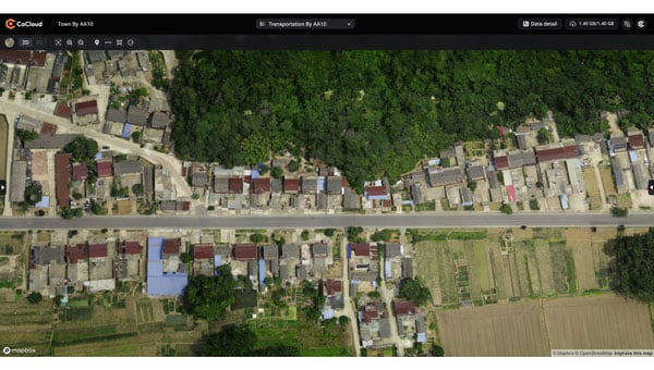
CHC Navigation (CHCNAV) has introduced CoCloud, a cloud-native platform developed for 3D data processing, management and collaborative analysis. The platform is designed to handle multi-source 3D data and supports streamlined workflows from data acquisition to deliverable creation, eliminating the need for local hardware investment.
CoCloud incorporates an advanced photogrammetry engine capable of efficiently processing data from sources such as aerial imagery and lidar scans. The platform produces digital orthophotos, point clouds and OSGB models with a high level of precision suitable for professional applications.
The platform offers tools for online data visualization, sharing and real-time collaboration on tasks such as volume calculations and point cloud editing. Its interface is designed to be intuitive and user-friendly, so users can perform complex 3D data operations without requiring extensive specialized training. CoCloud supports a range of data formats and includes features for dataset and timeline management.
Photo: CHCNAV
The platform offers API access and private deployment options, which allows organizations to integrate the platform into existing systems and customize workflows, from initial data collection through to final application delivery, according to their operational needs.
The platform uses distributed data centers located in Germany and Ireland for localized storage and processing. Both facilities comply with the European Union’s General Data Protection Regulation for reliable data protection throughout collection, transmission and storage.
“Seen & Heard” is a monthly feature of GPS World magazine, traveling the world to capture interesting and unusual news stories involving the GNSS/PNT industry.
West Point Cadets Map Electronic Warfare West Point cadets conducted a senior thesis project investigating the use of GNSS technology to map and visualize electronic warfare activities in the South Pacific, specifically focusing on GNSS spoofing. Their research, centered on the Huangpu River and Northeastern Shanghai, aimed to identify patterns of malicious GNSS interference and potential perpetrators, highlighting the strategic and economic motivations behind these actions in the region. By developing data visualizations of spoofing incidents, the cadets created a model that could be scaled up to analyze larger areas.
Credit: Eric S. Bartelt / USMA PAO-VI
South Africa Rising Above Water Researchers from the University of Bonn have found that South Africa’s land is rising by up to 2 mm per year, not because of deep mantle activity, but due to water loss from severe droughts. This uplift was detected using the TrigNet network of GNSS stations, which precisely measures changes in land elevation. As groundwater is depleted, the Earth’s crust rebounds upward — a process GNSS stations can monitor in real time.
Credit: THEGIFT777 / E+ / Getty Images
Türkiye to Launch Homegrown Satellite Navigation and Mapping System Türkiye is developing the Regional Positioning and Timing System (BKZS) to launch its own GPS and mapping application, in an effort to reduce dependence on foreign technology and enhance cybersecurity amid growing industrial automation. The system will provide precise location, navigation and timing data via Turkish satellites as an alternative to global systems including GPS, supporting critical sectors such as military operations, civilian communications, smart transportation, and precision agriculture.
Quantum Navigation System Serves as GPS Backup Q-CTRL, a quantum infrastructure software company based in Sydney, Australia, has demonstrated a new quantum navigation system, Ironstone Opal, as a backup to GPS technology. The Ironstone Opal system uses quantum sensors to detect variations in the Earth’s magnetic field, determining precise geographic coordinates with the help of artificial intelligence-based software. Ironstone Opal is passive and does not emit signals, making it resistant to detection and jamming. Field trials showed the system outperformed a high-end inertial navigation system and served as a reliable GPS backup by up to 50 times in ground vehicles and 11 times in aircraft.
Xona Space Systems’ Pulsar-0 satellite, the company’s first production-class asset for a commercial navigation constellation, is now operational and undergoing in-orbit testing. Launched in March 2024 on SpaceX’s Transporter-10 mission, Pulsar-0 is designed to assess the performance of Xona’s Pulsar architecture, which aims to provide high-accuracy, resilient positioning, navigation and timing (PNT) services from low-Earth orbit (LEO).
According to Xona, Pulsar-0 is transmitting LEO-based PNT signals using a payload built to support signal authentication and increased resilience against interference — capabilities that have become more important as concerns about vulnerabilities in traditional GNSS systems grow. The system’s encrypted and authenticated signals are intended to mitigate risks from jamming and spoofing, and deliver stronger, more reliable service in environments where legacy GPS may be degraded.
Xona’s Pulsar constellation is being developed as a commercial complement to GNSS, offering centimeter-level accuracy and greater resistance to interference through modernized signal design and LEO deployment. The company reports that its initial signal waveforms are already being used by select government and commercial partners for prototyping and validation.
Pulsar-0’s technical objectives include:
High-precision GNSS corrections: Real-time correction data from LEO, targeting position accuracy within 10 cm.
Signal authentication: Cryptographically verifiable signals to reduce the risk of spoofing.
Jamming resistance: A signal strength up to 100 times greater than GPS, enhancing reliability in contested or congested radio frequency environments.
Stronger signals: Stronger signals designed to perform in obstructed locations, such as indoors or in dense urban areas.
The Pulsar-0 mission is primarily focused on validating Xona’s core technology and enabling live sky testing with early partners, paving the way for future launches and eventual commercial operations. The company aims to launch a constellation of hundreds of satellites to provide persistent, redundant PNT coverage for sectors including defense, logistics, mining and autonomous systems.
Further details on Pulsar-0’s performance are expected as data collection and testing continue throughout the year.
Taoglas has introduced the Patriot series, a compact, multi-function combination roof mount antenna designed for connected vehicle fleets in emergency services, utilities and commercial sectors. The Patriot integrates up to 18 antenna elements within a single low-profile enclosure, aiming to provide robust multi-network connectivity while reducing vehicle roof clutter and simplifying installation processes
The antenna was originally developed for the Ford Interceptor, allowing for a direct replacement of the vehicle’s OEM antenna. This approach maintains the original antenna’s functionality and adds multi-radio connectivity, eliminating the need for additional holes to be drilled in the vehicle roof. The design is intended to streamline and reduce installation time and costs for upfitters, offering public departments potential savings on antenna-related expenses and removing the requirement to fill in roof holes when vehicles are resold.
The Patriot supports 5G and 4G cellular networks across the 600–6000 MHz range, dual-band GNSS (L1 and L1/L5) with a secondary GNSS (L1), Wi-Fi at 2.4 GHz, 5.8 GHz and 7.1 GHz, SDARS at 2.3 GHz, and LMR/TETRA at 380 MHz to 400 MHz and 700 MHz to 900 MHz. This enables the antenna to deliver concurrent broadband, navigation, telemetry and voice services. A dedicated whip element with full P25 VHF/UHF/700-900 MHz support is available in multiple lengths to meet various frequency requirements.
The platform is flexible and scalable, with the patent-pending design allowing for customization to specific application needs. Full 17- and 18-in-1 configurations are currently available, and additional variants with up to 18 integrated elements are planned based on customer requirements. This modular approach enables organizations to match antenna performance and connectivity with operational needs while maintaining a consistent mechanical design.
The Patriot’s housing is rated IK08 and IP69K for impact and water resistance, measuring 205 mm in length by 180 mm in width, with a variable whip height between 60 mm and 164 mm. The enclosure is designed to fit between vehicle roof ribs and uses the existing OEM mounting hole. A custom-engineered foam gasket ensures a secure and interference-free installation on curved vehicle roofs. The aerodynamic design is intended to enhance vehicle aesthetics and reduce wind resistance, and the antenna is available in black, white and other colors to match vehicle exteriors.
Signal performance is engineered for optimal gain, isolation and efficiency across all supported frequency bands. Cable types, lengths and connector options are customizable to suit specific installation requirements.