Sierra Space has successfully demonstrated its Resilient GPS (R-GPS) technology for the U.S. Space Force (USSF). This milestone, achieved in collaboration with General Dynamics Mission Systems, involved generating all GPS navigation signals required for the R-GPS mission. The technology seeks to address the growing need for resilient GPS systems capable of countering threats such as jamming and spoofing, which pose risks to the current GPS infrastructure.
GPS technology is integral to modern life, supporting civilian applications from smartphone navigation to critical military operations. However, as adversarial threats become increasingly advanced, there is a pressing need to enhance GPS resilience. To tackle this challenge, the USSF’s Quick Start program is focused on integrating smaller, cost-effective satellites into the existing GPS framework. These satellites would provide a rapidly deployable layer of protection against emerging threats, according to the USSF.
The demonstration evaluated hardware, firmware, and software performance, including the generation of P(Y), M-code and C/A signals at L1 and L2 frequencies. These capabilities ensure that R-GPS satellites can produce accurate and secure navigation signals compatible with devices used globally.
Sierra Space was awarded an R-GPS contract by the USSF Space Systems Command in September 2024 to develop design concepts for smaller and more affordable satellites. Following an internal Systems Requirements Review later that year, the company has now demonstrated its technological capabilities within months of the program’s inception.
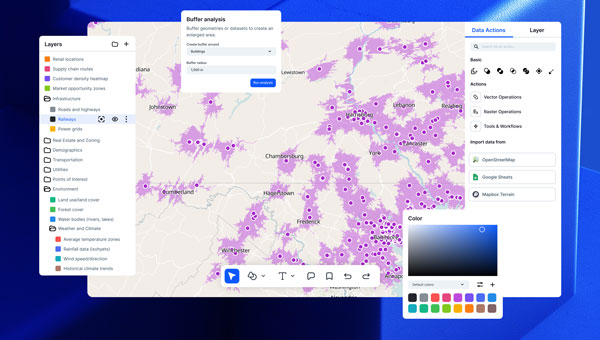
Atlas, a European cloud-based GIS platform, has introduced several new features aimed at simplifying geospatial workflows for teams without requiring coding expertise. The centerpiece of this launch is the Workflows engine, which allows users to visually design and automate spatial analysis processes — such as filtering data, performing calculations and updating layers — without writing code. By streamlining these tasks into automated chains, the feature seeks to reduce the time and effort traditionally spent on repetitive scripting.
Relations, a feature designed to connect datasets for smarter app development, enables users to link related data points, such as inspections or measurements, directly within the platform. Atlas also released Forms, a tool for structured field data collection, and Mobile Views, which allows users to build interactive mobile map applications. These tools aim to provide comprehensive geospatial capabilities for teams, eliminating the need for specialized development resources.
The Atlas platform offers real-time collaboration and no-code solutions for spatial analysis, automation, and app building. It as more than 10,000 users in 172 countries.
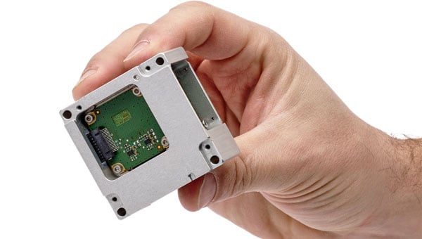
SBG Systems has unveiled its MEMS-based North-seeking inertial measurement unit (IMU) that operates independently of GNSS. According to the company, this launch lays the foundation for future products, such as attitude and heading reference systems (AHRS) and inertial navigation systems (INS), broadening the scope of MEMS-based navigation solutions.
The MEMS-based IMU can achieve a heading accuracy greater than 1° secant latitude without GNSS assistance. When integrated with GNSS and SBG Systems’ navigation algorithms, it can achieve INS heading accuracy greater than 0.01°.
The device features a true MEMS-based design with no moving parts, eliminating the need for carouseling mechanisms. This ensures enhanced durability and reliability across a wide range of operating environments.
Key features of this IMU include its compact size, low weight and minimal power consumption. Measuring 52 x 52 x 36 mm and weighing less than 150 g, it consumes only 2 watts of power. Designed for high-volume production, the device is well-suited for widespread adoption across industries. Additionally, its robust design offers long-term reliability in demanding conditions, and its ITAR-free status allows unrestricted global deployment.
SBG Systems has also developed new algorithms to enhance gyrocompass and INS alignment performance. These include a pure north-finding algorithm capable of rapid initialization in both static and dynamic conditions within one minute, as well as an advanced GNSS/INS fusion algorithm that delivers exceptional single-antenna heading accuracy even in low-dynamic environments.
It can be used for applications such as marine operations, autonomous systems and georeferencing. The IMU is particularly suited for subsea applications including remotely operated vehicles and autonomous underwater vehicles, as well as geospatial and marine surveying tasks requiring precise single-antenna heading accuracy.
The first off-the-shelf solutions are expected to be available by early 2026.
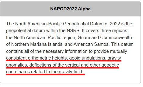
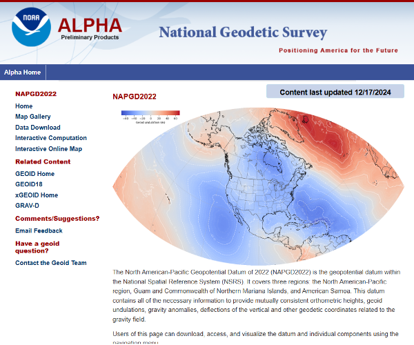
My January 2025 GPS World newsletter mentioned that the National Geodetic Survey (NGS) made several updates to the North American-Pacific Geopotential Datum of 2022 (NAPGD2022) products and that these updates are now available on the NGS alpha site. NGS held a webinar on Jan. 9, 2025, to discuss NAPGD2022 and explain the product updates. I highlighted the NGS Alpha site and GEOID2022 — a product of the NAPGD2022 — in my July 2024 newsletter.
This newsletter will highlight the NAPGD2022 alpha site and the components on the Alpha site — GEOID2022, DEFLEC2022, DEM2022 and GRAV2022. See below for a description of the site.
NGS users of the new National Spatial Reference System (NSRS) should determine the impact on their products and services. For example, the effect of using NAPGD2022 orthometric heights instead of the North American Vertical Datum of 1988 (NAVD 88) on flood plain maps and FEMA elevation certificates.
I have experience dealing with the impact of products and services changing from one national vertical datum to another. When I worked for NGS, I was the Project Manager of NAVD 88. The adjusted heights from the NAVD 88 general adjustment were officially published on June 15, 1991. Performing the adjustment of NAVD 88 was a relatively simple task compared to implementing of NAVD 88 in geospatial products and services in the United States. I wrote articles and talked about the change in the datum from the National Geodetic Vertical Datum of 1929 (NGVD 29) to NAVD 88 at surveying and mapping conferences several times a year during the decade before the completion of the adjustment. Many users were still surprised by the change and the impact on their products and services. It’s a little different today because there are more ways of getting the word out in today’s digital world, such as webinars, Zoom meetings and digital magazines. That said, users still need to participate in webinars and Zoom meetings and read digital articles to understand the changes to geospatial products and services.
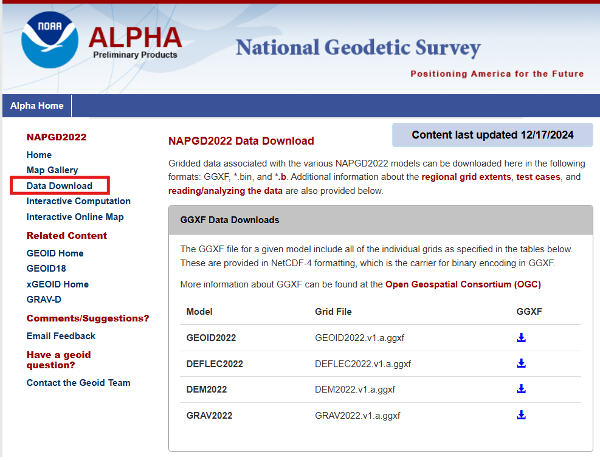
Users can download gridded files of the models to create their own routines to analyze the models in their region.
Photo: NGS
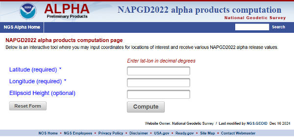
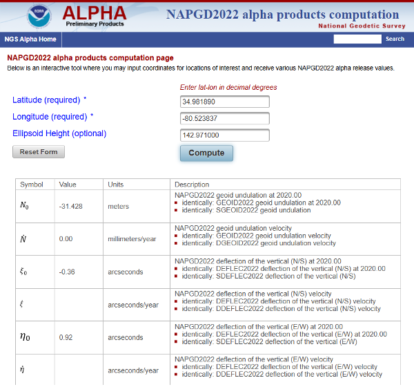
The site provides an option for users to perform single point interactive computations.
Single point interactive computations. (Photo: NGS)
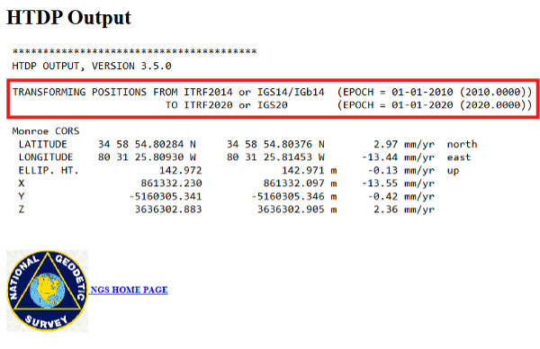
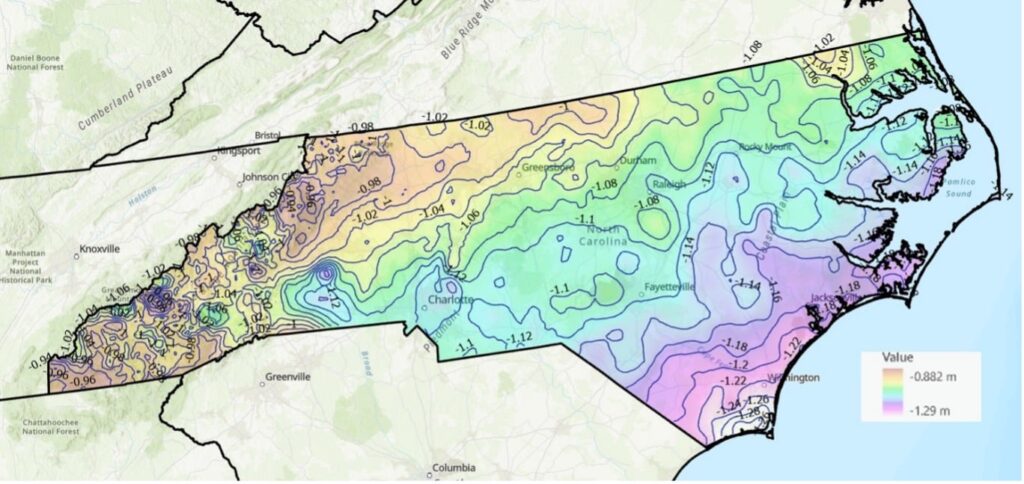
The differences between the ITRF 2014 (epoch 2010.0) coordinate and ITRF 2020 (epoch 2020.0) in North Carolina are not very large. Still, I used NGS’s HTDP tool to transform the North Carolina Monroe CORS (NCMR) ITRF 2014 (epoch 2010.0) coordinates to ITRF 2020 (epoch 2020.0) and then entered the transformed values into the interactive tool. See the images “HTDP Output for NCMR” and “Interactive Computation Page” for an example of the output of the single-point interactive computation tool.
HTDP output for NCMR. (Photo: NGS) Photo: NGS
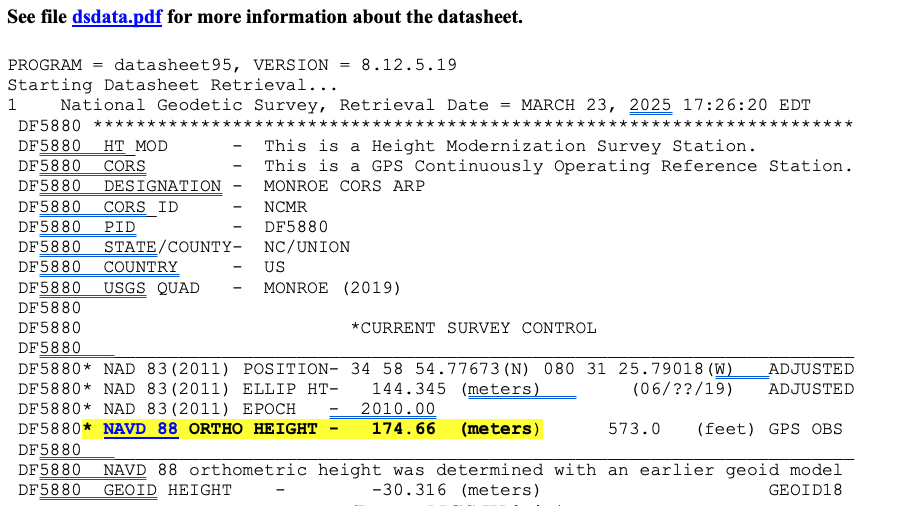
I have highlighted the NAPGD2022 orthometric and dynamic heights for NCMR CORS. I downloaded the latest NGS datasheet for the North Carolina Monroe CORS (NCMR) to obtain the published NAVD 88 height. See the image below.
NGS data sheet for Manroe CORS. (Photo: NGS)
In my example, the difference between the NAPGD2022 and NAVD 88 orthometric height is -0.26 meters (174.40 m – 174.66 m). It should be noted that the tool also provides a dynamic height for the mark. Dynamic heights are used by the International Great Lakes Datum (IGLD). My August 2021 GPS World Newsletter provides more information on the update to the IGLD 85 and dynamic heights. The interactive computation page tool also provides the GEOD2022 value for the mark. The difference between GEOID2022 and GEOID18 for the mark is -0.112 meters (-31.428 minus -30.316).
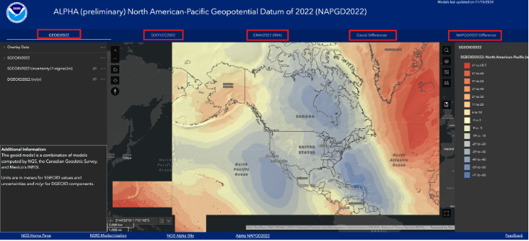
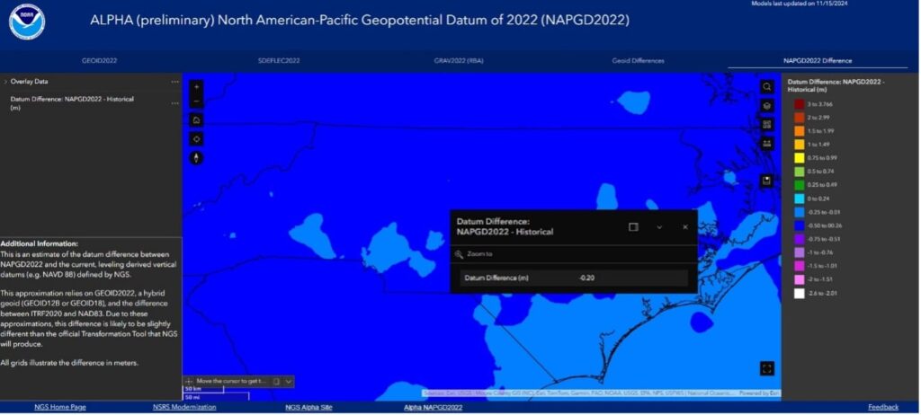
The alpha site provides an option to use an interactive online map that allows users to access GIS maps that depict individual models. I have highlighted the five layers on the box titled “NAPGD2022 Interactive Online Map” – GEOID2022, SDEFLEC2022, GRAV2022 (RBA), Geoid Differences, and NAPGD2022 Differences.
To demonstrate the online maps, I clicked on the layer titled “NAPGD2022 Difference” located in the upper right corner of the of the map. The image below provides a description of the layer.
Photo: NGS
Users can click on the map, and the pop-up provides information about the location. In the example below, the popup provides the difference between the NAPGD2022 orthometric height and the NAVD 88 height.
The difference between NAPGD2022 orthometric height and NAVD 88 height. (Photo: NGS)
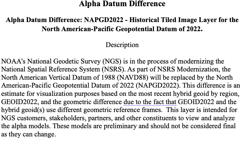
Additional information about a layer is provided on the lower left side of the map page.
Additional information for NAPGD2022 difference. (Photo: NGS)
NGS’ online maps didn’t depict the details I wanted to visualize, so I downloaded the data and created my own maps.
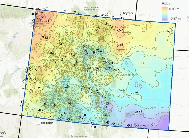
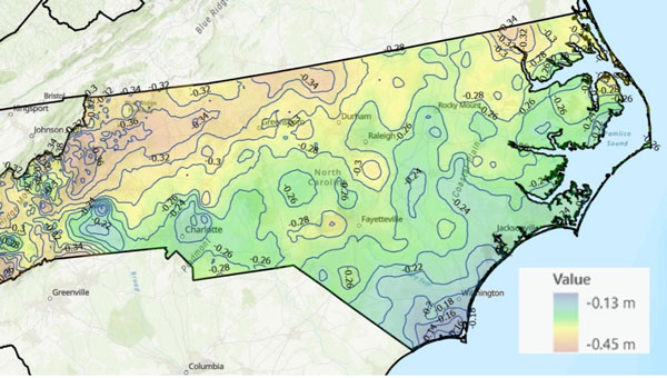
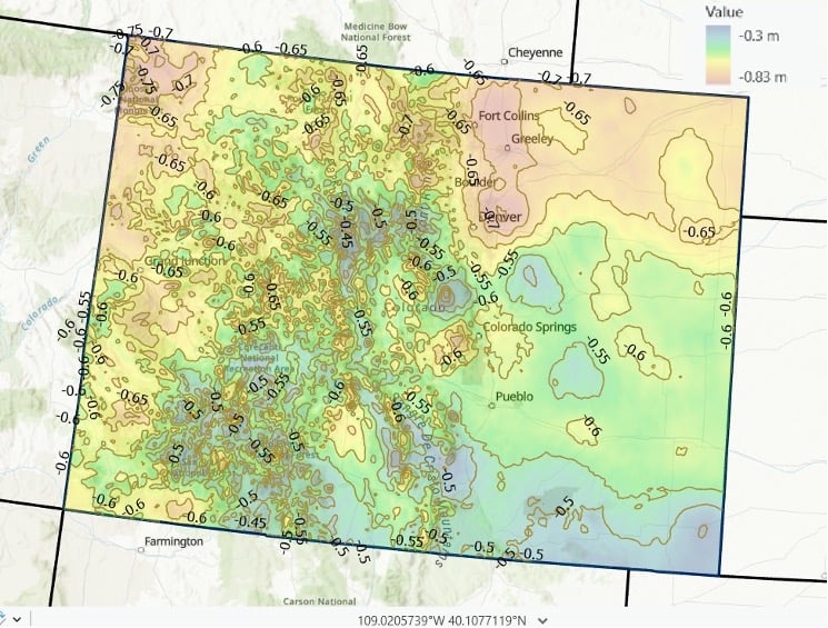
I provided a couple of examples of the differences between NAPGD2022 and NAVD 88 below: one for North Carolina and one for Colorado. As you can see from the plots, there are significant relative differences in mountainous regions (western North Carolina and western Colorado), and a lot of local variation across the state.
Differences between NAPGD 2022 orthometric heights and NAVD 88 in North Carolina (2 cm contour intervals). (Photo: Dave Zilkoski) Differences between NAPGD 2022 orthometric heights and NAVD 88 in Colorado (5 cm contour intervals). (Photo: Dave Zilkoski)
I used the same process to determine the differences between GEOID2022 and GEOID18. See the images titled “Differences between GEOID2022 and GEOID18 in North Carolina” and “Differences between GEOID 2022 and GEOID 18 in Colorado.” Again, it should be noted that there is a lot of variation across the state.
Differences between GEOID2022 and GEOID18 in North Carolina (2 cm contour intervals). (Photo: Dave Zilkoski) Differences between GEOID 2022 and GEOID 18 in Colorado (5 cm contour intervals). (Photo: Dave Zilkoski)
In summary, in a few months, NGS will be releasing a Beta version of the new terrestrial reference frames and geopotential datum. This newsletter highlighted the NAPGD2022 alpha site and the components on the Alpha site — GEOID2022, DEFLEC2022, DEM2022, and GRAV2022. I did a 4-part series in my GPS World newsletters in 2017 on the products of NAPGD2022 (June 2017, August 2017, October 2017 and December 2017).
Unicore has introduced the UM981 series, a high-precision positioning module that integrates RTK and inertial navigation system (INS) technologies. The solution leverages GNSS and INS navigation to cater to applications in precision agriculture, surveying and mapping.
The module is compatible with all major navigation systems and frequencies, tracking signals from multiple systems simultaneously for enhanced performance even in challenging environments. Additionally, the UM981 series supports open Precise Point Positioning (PPP) services such as BDS-3 PPP-B2b, Galileo E6 HAS and QZSS L6 MADOCA-PPP, achieving 10 cm positioning accuracy with a convergence time of under 10 minutes, according to Unicore.
The UM981 series processes high-frequency GNSS and IMU data streams efficiently, offering RTCM data transmission at up to 20 Hz, single-point positioning and RTK at up to 50 Hz and integrated navigation data and IMU raw data at up to 100 Hz. These capabilities make it suitable for dynamic scenarios requiring high precision.
In precision agriculture, the UM981 module simplifies machinery auto-steering systems by enabling single-antenna positioning and attitude determination through advanced MEMS technology. At speeds above 1 km/h, it achieves heading accuracy better than 0.3° and roll/pitch measurements better than 0.2°, with accuracy improving as speed increases. The module supports CAN Bus communication and can be customized to work with the ISOBUS Protocol, eliminating the need for switching between interfaces during serial port communication.
For surveying and mapping applications, the UM981S variant delivers high-accuracy positioning and tilt measurement using GNSS and INS fusion algorithms. It eliminates traditional shake-to-start requirements with a walk-and-go feature that allows users to initialize tilt measurement simply by walking with the measurement pole. The module provides 2.5 cm accuracy within a 30° tilt range and supports measurements at larger angles up to 120°, making it suitable for complex environments such as building corners or areas under tree canopies.
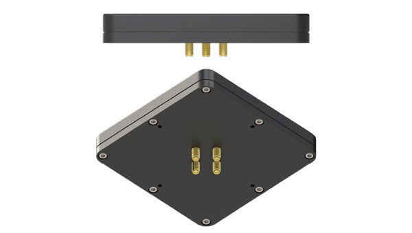
The AJ977XF+ is a Fixed Reception Pattern Antenna (FRPA) designed to enhance GNSS resilience in interference-prone environments.
LEANA technology creates a 20 dB null over all azimuths, from ground level to an elevation angle of ~15°.
XF+ technology provides additional protection by filtering out-of-band signals.
The “+” technology supports two independent RF channels — if the L1 channel is jammed, the L2/L5 channel will continue to provide a usable signal (and vice versa).
Key takeaway: LEANA technology enables your GNSS receiver to function when it’s 10 times closer to a jammer or interference source compared to a standard antenna and receiver pair.
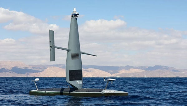
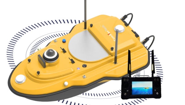
Saildrone has equipped its Voyager platform with new hardware and software algorithms, allowing it to operate in areas affected by GPS jamming and spoofing.
The company successfully demonstrated these capabilities in the Middle East, showcasing its ability to function autonomously in GPS-denied environments. According to Saildrone, the tests addressed challenges posed by regional electronic warfare tactics, such as jamming and spoofing, which have disrupted unmanned systems in contested maritime zones.
Task Force 59, established by the U.S. Navy in 2021 under NAVCENT and the Fifth Fleet, has been instrumental in integrating unmanned systems and artificial intelligence into fleet operations. Saildrone engineers developed a localization solution that does not rely solely on satellite navigation, offering seamless operation even in denied environments. This capability was demonstrated during IMX 2025, where Saildrone’s Voyager platform stood out as the sole unmanned vessel capable of persistent surveillance under such conditions.
Saildrone USVs are actively conducting wide-area surveillance across the CENTCOM area of responsibility, enhancing maritime domain awareness and supporting U.S. Navy operations. These efforts align with Operation Prosperity Guardian, which has been safeguarding commercial shipping and countering regional threats since December 2023.
Saildrone is now in its fourth year of collaboration with the U.S. Navy, with its unmanned surface vehicles deployed across various regions, including the Middle East, Atlantic, Caribbean and Pacific Oceans.
The Federal Communications Commission (FCC) has issued a Notice of Inquiry (NOI) seeking public input on positioning, navigation and timing (PNT) systems and policies. While GPS is crucial for the United States’ economic and national security, its dependency as a single point of failure renders it vulnerable to disruption or manipulation by adversaries. Recognizing this vulnerability, leaders such as President Trump, Chairman Cruz, and Senator Markey have advocated for developing alternative systems to ensure resilient PNT capabilities.
PNT data is integral to countless military, public safety, agricultural, and commercial activities. Given the dependence of the American economy and national security on GPS as the sole PNT source, the agency states that the U.S. government is prioritizing efforts to create robust backup systems that can safeguard essential functions in the event of GPS signal disruptions.
The FCC’s NOI examines how the agency can foster the development of alternative and complementary PNT. It seeks feedback on various emerging PNT technologies being developed by broadcasters, wireless operators, satellite constellations and startups utilizing FCC-licensed spectrum. The inquiry also addresses tradeoffs among these technologies based on performance, scalability, geographic coverage, durability, cost and commercialization potential.
The Commission aims to establish a comprehensive record to guide its actions in enhancing GPS resilience and promoting alternative PNT solutions. Potential measures include regulatory changes, public-private partnerships, testbeds, Innovation Zones and other initiatives.
Two PNT-related petitions are currently under FCC consideration. NextNav has proposed allocating approximately $5 billion worth of spectrum to collaborate with telecom providers in establishing a PNT network. Meanwhile, the National Association of Broadcasters (NAB) has suggested adopting a new TV signal format capable of transmitting PNT information without requesting additional spectrum allocation. Insights from the NOI will help inform decisions on these proposals.
The FCC’s inquiry reflects growing concerns about reliance on GPS as a single system for PNT data. By fostering alternatives like terrestrial networks or broadcast-based solutions such as NAB’s Broadcast Positioning System, the Commission seeks to strengthen national resilience against potential disruptions to critical infrastructure and services.
ComNav Technology has released the SV600 unmanned surface vessel (USV) for hydrographic surveying. This remote-controlled vessel incorporates adaptive water-flow straight-line and hovering technology, enhancing efficiency and ease of operation.
A key feature of the SV600 is its dual-moon pool design, which allows for simultaneous deployment of various surveying equipment. This includes Acoustic Doppler current profilers, single-beam echo sounders, side-scan sonar, pipeline detectors and miniaturized multi-beam echo sounders.
The vessel’s design prioritizes versatility and quick transitions between tasks. Its rapid installation feature facilitates seamless switching between different measurement modes, streamlining the surveying process, according to ComNav.
ComNav Technology has revealed the LS600, a handheld 3D laser scanner that integrates SLAM technology, a built-in RTK module and dual 16MP wide-angle cameras. The device employs multi-sensor fusion, including lidar, IMU and cameras, to deliver high performance in both indoor and outdoor environments. It offers 16- or 32-line lidar options, with a scanning range of up to 300 m and a speed of 640,000 points per second for rapid data collection.
The LS600 features an advanced GNSS module that provides centimeter-level accuracy with full-frequency GNSS support. A built-in surveying antenna enhances signal reliability. The dual-lens camera, combined with visual SLAM (V-SLAM), produces detailed color point clouds for realistic and precise visuals. The scanner supports both backpack and pole configurations, making it versatile for applications such as land surveying, engineering, urban renewal, mining, agriculture, forestry and emergency response.
Its automated post-processing capabilities — such as stitching, denoising, and rendering — along with flexible coordinate systems streamline workflows and ensure accurate results. This design allows professionals to achieve precision and efficiency in the field.
Inertial Labs, a VIAVI Solutions Inc. Company, has introduced the M-AJ-QUATRO anti-jamming antenna system, designed to ensure assured positioning, navigation and timing (A-PNT) in GNSS-challenged environments. The system incorporates advanced Controlled Reception Pattern Antenna (CRPA) technology and digital processing capabilities, making it suitable for applications ranging from military operations to commercial aviation.
PNT services are increasingly critical for various sectors, including transportation, telecommunications, artificial intelligence, hyperscale data centers, energy, finance and defense. As GNSS jamming and spoofing threats grow, government agencies and industry leaders are working to address these challenges. For instance, the Federal Aviation Administration and Naval Air Warfare Center Aircraft Division are expediting approval processes for CRPA technology to enhance aviation safety and counter GPS interference.
The M-AJ-QUATRO supports the L1, L2, and L5 GNSS bands and offers robust interference suppression capabilities. Its adaptive digital nulling feature automatically mitigates jamming signals with over 34dB+ suppression in the export-free version and over 45dB+ suppression in the export-controlled version. Additionally, the system can identify and locate sources of interference through its jammer direction-finding capability, improving situational awareness.
It is compatible with multiple GNSS constellations to provide comprehensive global coverage. It employs dual FPGA-based encryption and anti-spoofing technologies for secure signal processing and data integrity. Built to meet stringent military standards like MIL-STD-810G and MIL-STD-461F, the M-AJ-QUATRO is engineered to withstand extreme conditions, making it an ideal solution for defense and aerospace applications.
ComNav Technology has upgraded its Survey Smart software, enhancing its power, user-friendliness, compatibility, file sharing capabilities, CAD engine and surveying performance.
The update introduces a new user interface optimized based on user habits. It features a new visualization interface, a restructured CAD layout and a flexible toolbar that consolidates common functions across scenarios.
ComNav’s self-developed core component, CADX, has been upgraded to enable instant loading of large drawings for smooth operation. The SinoGeoX feature seamlessly integrates CAD with maps. A new Standing Survey feature has been added to the IMU mode. When activated, it automatically measures points after the receiver remains stationary for 2 seconds, eliminating the need for manual clicks.
File sharing capabilities have been enhanced, allowing files to be downloaded via QR code scanning on handheld collectors or other devices. One-click transfers between collectors, smartphones, and PCs enable cross-platform collaboration and rapid sharing.
The software also now includes RTK PPP Fusion, which seamlessly switches to PPP solutions when RTK signals drop. This maintains operational continuity with PPP accuracy up to 20 cm. It supports echo sounders for precise depth data and WMS services for synchronized, customizable map data.