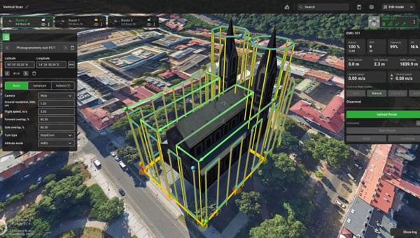
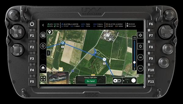
SPH Engineering has released an updated version of its UgCS UAV mission planning software, introducing significant improvements in elevation data accuracy and user control over flight parameters. The latest version allows users to explicitly set flight altitude for photogrammetry and corridor mapping missions, moving beyond the previous requirement to use ground sample distance as the primary input. This change seeks to offer UAV operators greater clarity and precision, particularly for operations that demand specific altitudes and a clear understanding of expected image resolution.
For users in the United States, UgCS now integrates USGS 1/3 Arc Second elevation data by default. This enhancement increases the resolution of elevation data from one data point every 30 m to one every 10 m, designed to improve the accuracy of terrain-following missions and making flight operations safer and more efficient in complex or mountainous areas.
The update also brings several interface enhancements designed to streamline the mission planning process. The ‘Export Route’ button is now more prominent, making it easier for users to access, especially those using the UgCS Open version. When creating a new route, the software displays the five most popular drone models first, simplifying selection for common platforms. For drones equipped with multi-lens cameras, UgCS now defaults to the wide camera during photogrammetry route planning, reducing the need for manual adjustments.
Additionally, the Visual Inspection route category has been improved with the introduction of a Circle tool, which simplifies the planning of circular orbits around specific points of interest. No-Fly Zones are now disabled by default in new installations, allowing for faster mission setup. The new version also expands hardware compatibility by adding support for the DJI M3D and M3TD UAVs.
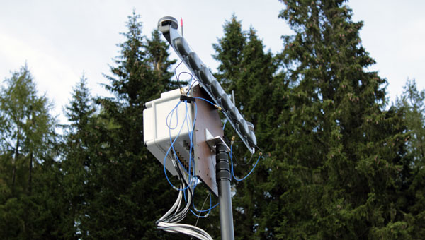
Balboa Geo, in partnership with the Texas A&M Engineering Extension Service (TEEX) and the George H.W. Bush Combat Development Complex (BCDC), completed a rigorous field testing campaign of its POINTER system, a “dual-use,” real-time alternative positioning, navigation and timing (A-PNT) technology designed for GPS-denied, degraded and disrupted environments, including indoor, subterranean and obstructed urban settings.
The POINTER field test plan, led by Balboa Geo’s Andrew Aubrey, Ph.D., with technical support from TEEX and Texas A&M Professor Stacey Lyle, Ph.D., RPLS, involved 130 tests across seven challenging testing and training venues located at TEEX and the BCDC.
Test venues included:
A three-story concrete structure with 10-inch-thick, rebar-reinforced concrete walls
A compartmentalized steel-hulled ship with three decks reaching approximately 25 ft high
A steel shipping container (CONEX)
A simulated collapsed structure and rubble pile composed of steel, concrete, and a 90° tunnel network
A simulated industrial oil refinery with processing equipment and complex, elevated steel piping
A six-story steel training tower with metallic siding throughout
The BCDC military-grade subterranean tunnel network, featuring a main tunnel at about 10 ft deep and a heavily shielded segment with Faraday cage properties simulating greater depth
Rigorous test design and real-time A-PNT data collection
The POINTER field test plan deployed a Base Station Laptop (BX) and a single Transmitter (TX) emitting an omni-directional Magneto-Quasistatic (MQS) field outside each venue. Two Receivers (RX) were introduced at various internal locations to capture multiple “XYZ” axis measurements within each GPS-denied setting. Tests were repeated to validate reproducibility, with highly precise measurements taken where possible for ground truth position references.
The BCDC military-grade tunnel network testing consisted of “normal” and “inverted” configurations. The “inverted” test consisted of placing the TX at depth within the tunnel network, with the BX and RX units located externally.
Highlights of the summary results and key findings:
MQS field penetration and position location were achieved at all seven test venues.
Real-time, three-dimensional distance measurements were obtained for all 130 tests.
The mean positional uncertainty across all venues was 12.62 cm.
Positional uncertainty ranged from 2.5 cm to 36 cm, depending on venue complexity, receiver location, and transmitter-receiver distance.
Vertical measurements at the concrete structure showed uncertainties as low as 2.5 centimeters at a distance of about 11 m, and up to 24 cm at about 30 m.
The POINTER system demonstrated penetration into and out of the BCDC military-grade tunnel network, including the shielded portion, indicating flexibility and performance in challenging subterranean environments.
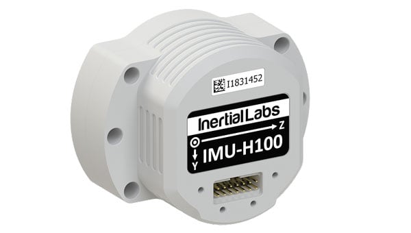
Inertial Labs, a VIAVI Solutions company, has released the IMU-H100, a micro-electromechanical systems inertial measurement unit (IMU) designed to improve tactical guidance and navigation for UAVs, short-range missiles, precision-guided munitions and a range of commercial applications.
As technology for unmanned vehicles advances and safety considerations take precedence, both military and commercial sectors are increasing their adoption of IMUs, which are critical for navigation and control systems. An IMU can track angular velocity and linear acceleration using MEMS gyroscopes and accelerometers. These devices are now considered essential for guidance, navigation, orientation and stabilization, especially in short- and medium-range flight control systems. Their applications extend to autonomous vehicles operating on land, at sea and in aerospace and defense sectors.
The IMU-H100 is a tactical-grade unit that features accelerometers and gyroscopes on all three axes. It offers a gyro bias of 1° per hour and an accelerometer bias of 1 mg. The unit measures 5 cubic inches and weighs 160 g. According to the company, the IMU-H100 surpasses comparable products in data rate, measurement range, stability and repeatability, even under challenging conditions such as vibration, shock, high acceleration, spinning, temperature changes and acoustic noise.
The U.S. Army has selected AEVEX Aerospace to participate in the Launched Effects-Short Range Special User Demonstration, an initiative aimed at advancing the Army’s integration of sophisticated uncrewed systems to improve battlefield effectiveness. AEVEX will present its Atlas Group II launched effect during the demonstration, a lightweight and agile system engineered for precision missions that directly support frontline troops. The Atlas system reflects AEVEX’s commitment to developing innovative technologies that address the Army’s evolving operational threats and mission requirements.
Throughout the demonstration, soldiers from various Army branches — including field artillery, infantry, and aviation — will operate the Atlas system to refine tactics, techniques and procedures. Their hands-on feedback will play a critical role in shaping how the Army employs launched effects in the future, influencing both requirements and operational strategies.
A new prototype sensor developed by the NATO Communications and Information Agency has completed a significant round of testing, marking a step forward in NATO’s electromagnetic warfare capabilities. The sensor, GANDALF 4, underwent a series of tests at an advanced anechoic chamber operated by the NATO Support and Procurement Agency. This facility serves as a controlled environment for precise calibration and detailed performance assessment of the sensor’s antenna array, which is critical for ensuring the system’s accuracy and reliability.
GANDALF 4 was developed by specialists at the agency’s Joint Intelligence, Surveillance and Reconnaissance Centre. The system is designed to detect, classify and locate deliberate attempts to interfere with or manipulate GNSS signals. GNSS jamming and spoofing are becoming more frequent and sophisticated, posing challenges to NATO’s operational readiness and resilience. The development of GANDALF 4 is designed to enhance situational awareness in contested electromagnetic environments.
The recent testing phase focused on evaluating the antenna performance of the sensor. Collaboration between the agency’s Electromagnetic Warfare and Surveillance team and the procurement agency’s Ground Based Defence group played a central role in the campaign, facilitating knowledge transfer and improving efficiency, according to the team.
“Seen & Heard” is a monthly feature of GPS World magazine, traveling the world to capture interesting and unusual news stories involving the GNSS/PNT industry.
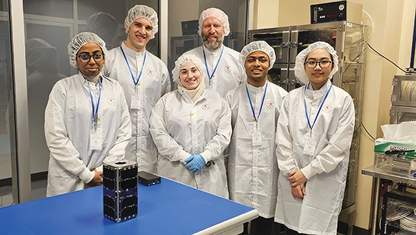
UNB students prepare for second satellite mission
The CubeSat team at the University of New Brunswick (UNB) is developing a second satellite after its first, VIOLET, failed to communicate with Earth. The team is refining its design based on lessons learned from the initial mission. VIOLET, deployed in 2024, was created through a partnership between UNB, the Université de Moncton and the New Brunswick Community College as part of the Canadian Space Agency’s CubeSat Project. This initiative provides students with hands-on experience in designing, building, testing, launching and operating miniature satellites.
GPS technology played a crucial role in preventing disaster during an EasyJet flight, The Daily Mail reported. As the Airbus A320 descended toward Hurghada, Egypt, it approached dangerously close to a mountain range, flying at an altitude of 3,100 ft — just 770 ft above the peak of the mountain. The Ground Proximity Warning System, which relies on GPS-enabled terrain data, alerted the cockpit with warnings such as “pull up, terrain ahead.” This alarm prompted the pilot to perform an emergency maneuver by pulling up the joystick to level off the plane, narrowly avoiding collision and saving all 190 passengers on board.
Gulf of America’ name change leaves decisions for map creators
Photo: TomTom
With the U.S. government now recognizing the Gulf waters as the “Gulf of America” and not the “Gulf of Mexico,” TomTom is introducing a U.S. geopolitical view for its users in the United States; they will see “Gulf of America.” Translations will be available in English, Spanish, French and German, and users searching for “Gulf of Mexico” will find the “Gulf of America.” Map users outside of the United States will see the default map view showing the “Gulf of Mexico.” Users searching for “Gulf of America” will find the existing “Gulf of Mexico” feature. All users will be able to change the view based on their preferences
New ‘surveyor’ app for improved mapping accuracy
Photo: Apple
Apple launched the Surveyor app, a tool designed to enhance the accuracy of Apple Maps by collecting real-world mapping data. According to Apple, Surveyor relies on partner companies and users to gather data along assigned routes. The app focuses on capturing detailed information such as street signs, traffic signals and roadside features, which are then transmitted to Apple for precise map updates. By leveraging community-driven data collection, Apple aims to refine its mapping ecosystem and keep critical details current.
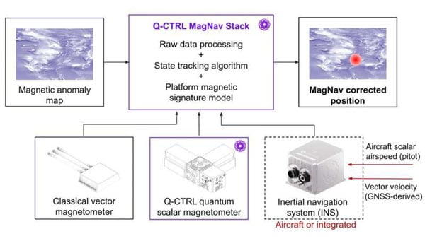
A team of researchers at Q-CTRL, a quantum infrastructure software company based in Sydney, Australia, has completed a successful demonstration of a new quantum navigation system called Ironstone Opal. The group described the system’s operation and performance in a paper posted to the arXiv preprint server.
GPS technology is widely used for navigation in both civilian and military vehicles and aircraft. However, the increasing reliance on GPS has highlighted its vulnerability to outages, which can leave drivers stranded, force pilots to rely on outdated methods and complicate the deployment of military assets. These concerns have driven efforts worldwide to develop robust backup systems or alternatives to GPS.
Q-CTRL’s Ironstone Opal is designed as a backup navigation system and, according to the research team, can deliver accuracy up to 50 times greater than existing GPS backup systems in certain scenarios. The system leverages quantum sensors that are highly sensitive to variations in the Earth’s magnetic field. Because the magnetic field differs depending on geographic location, these sensors can precisely determine an object’s position by reading the field and using artificial intelligence-based software to generate geographic coordinates similar to those provided by GPS.
The research team shared that unlike conventional systems, Ironstone Opal is passive, meaning it does not emit signals that could be detected or jammed by adversaries. The system’s software is designed to filter out noise from vehicles or aircraft carrying the sensors, and the hardware is compact enough for installation in cars, trucks, UAVs and aircraft.
Field trials conducted by Q-CTRL included both ground vehicles and aircraft. The results showed that Ironstone Opal outperformed a high-end inertial navigation system, a standard GPS backup, by up to 50 times in ground tests and by at least 11 times in airborne tests. These trials demonstrated the system’s ability to maintain high accuracy under a range of environmental conditions, altitudes, and maneuvers, with positioning uncertainty as low as 0.01% of the total distance traveled in the best cases.
Q-CTRL’s approach combines proprietary quantum magnetometers with advanced denoising and map-matching software, allowing the system to detect subtle magnetic “landmarks” in the Earth’s structure. The technology is designed to be resilient, unjammable, and suitable for integration into a wide range of platforms, including autonomous vehicles and commercial aircraft.
AgEagle Aerial Systems has released its eBee VISION application software, introducing a suite of updates designed to enhance drone navigation in environments where GNSS signals are compromised or unavailable.
The latest software enables autonomous position updates with map referencing, allowing for precise navigation even when satellite signals are jammed, spoofed or blocked, according to the company. This seeks to provide operational continuity for defense personnel, public safety agencies and industrial teams operating in high-stakes, GNSS-denied environments such as dense urban centers, near critical infrastructure or in contested zones with active signal interference.
The update also introduces features such as optical flow stabilization for target lock, which uses visual cues to keep the camera centered on a point of interest during zoom-ins or drone movement. The software allows for adaptive behavior after GNSS recovery or visual repositioning, enabling seamless transitions if the drone’s position suddenly updates due to GNSS recovery or visual geo-referencing.
Additional enhancements include real-time mission duration and return-to-home estimates, optimized cruise speed in windy conditions, high-precision landings using lidar-based altitude calibration, a gimbal auto-recovery mechanism to clear obstructions mid-flight and smart motor speed reduction to prevent overheating during extreme conditions.
AgEagle, founded in 2010, designs and delivers flight hardware, sensors and software for users in energy, construction, agriculture and government sectors worldwide.
The United States Navy’s Naval Air Systems Command (NAVAIR) has awarded TrustPoint a $1.2 million Small Business Innovation Research Phase II contract. The funding supports the initial delivery and demonstration of TrustPoint’s C-band GNSS service-enabled receivers for the U.S. government. TrustPoint is collaborating with Hexagon U.S. Federal and NovAtel, both part of Hexagon.
This project combines TrustPoint’s C-band services with NovAtel’s GNSS receiver technology, aiming to advance resilient positioning, navigation and timing solutions for military use. The partnership draws on extensive experience in military-grade GNSS equipment and services, and represents a significant step in developing technology that can operate reliably in challenging operational environments.
The contract highlights the increasing importance of frequency and orbital diversity for future navigation and timing needs. With Hexagon as a key partner, TrustPoint is positioned to address the Department of Defense’s evolving requirements for assured PNT, supporting mission continuity even in contested environments
Hydro-Tech has unveiled the MS400C, a fully integrated multibeam echosounder designed for uncrewed surface vessels. The new system combines sonar processing, inertial navigation, GNSS positioning and sound velocity sensing into a single unit.
The MS400C seeks to address deployment challenges faced by USV operators during hydrographic surveying. Its compact, lightweight design allows direct mounting on small platforms. Installation involves connecting a few cables to the IPC and power supply and to the primary and secondary GNSS antennas. With preconfigured spatial relationships, operators can deploy and start surveying quickly, reducing configuration errors and ensuring consistent data quality. Equipped with Auto Survey functionality, the system calibrates parameters based on water conditions, which streamlines pre-survey procedures. Real-time roll compensation and attitude data from the internal IMU, combined with sound velocity profiling, ensure high-fidelity depth measurements, even in dynamic conditions. Designed for autonomous and remotely operated survey platforms, the MS400C supports data collection in confined waterways.
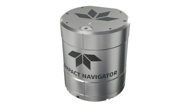
Teledyne Marine has launched the Teledyne Compact Navigator, an ultra-compact autonomous integrated navigation system engineered for subsea and surface vehicles. It is ideal for small vehicles, enabling inspection and survey operations on compact platforms. The system is offered in two depth-rated models, one capable of operating at 4,000 m and another at 300 m. The Compact Navigator consumes less than seven watts of power, extending mission duration by conserving energy. The system operates fully autonomously, eliminating the need for external aiding or operator intervention. Advanced phased array Doppler Velocity Log (DVL) technology enhances performance while allowing the device to be mounted on an autonomous underwater vehicle or ship hull.
Compact Navigator supports a broad range of applications, including ROVs, AUVs, shallow water surface navigation, operations in GNSS-denied environments and dynamic positioning for surface vehicles. The system provides true North-seeking gyrocompass-grade performance, and its web-based user interface supports integration, operation, and troubleshooting. It is factory-calibrated and offers a battery backup option for reliability in demanding conditions. The system operates independently of satellite signals, making it resistant to jamming or signal loss. This capability is significant for shallow water navigation, where GNSS-based systems may be unreliable.
Read a roundup of recent products in the GNSS and inertial positioning industry from the April 2025 issue of GPS World magazine.
OEM
INS With three additional GNSS receiver variants
Photo: Topcon
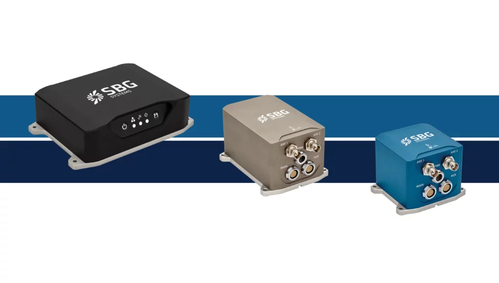
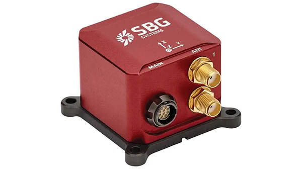
SBG Systems has upgraded its inertial navigation systems — Ekinox, Apogee and Navsight — with new GNSS receiver options. The latest update introduces three additional GNSS receiver variants.
These include:
Marinestar, which supports Fugro Marinestar, delivering precise point positioning (PPP) with centimeter-level accuracy via L-band corrections without requiring a base station. It is optimized for marine applications.
HAS Ready / NavIC, which includes Galileo E6 support for the upcoming Galileo High Accuracy Service (HAS), offering free decimeter-level PPP corrections globally. Additionally, it supports the Indian NavIC system.
Centimeter-Level Augmentation Service, which is tailored for users in Japan; this variant utilizes QZSS L6 signals to provide free PPP corrections without external services.
All GNSS variants integrate seamlessly with SBG Systems’ antenna portfolio and Qinertia post-processing software. Users select the appropriate GNSS variant at purchase to match their operational requirements. These enhancements aim to provide versatile solutions across diverse industries while ensuring reliable performance.
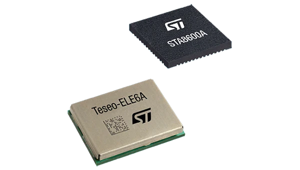
The GNSS receivers in the Teseo VI family use multi-constellation and quad-band signal processing on a single chip, achieving centimeter-level accuracy for various applications. The Teseo VI family includes the STA8600A and STA8610A models. These receivers are designed for automotive applications such as advanced driver assistance systems and autonomous driving, as well as industrial uses, including asset tracking, mobile robots and precision agriculture.
The Teseo VI+ variant can host enhanced positioning engines developed by third-party companies, providing real-time kinematics for centimeter position accuracy.
The LG680P is a multi-constellation, quad-band GNSS module designed for high-precision positioning and to enhance signal quality and precision through concurrent reception of L1, L2 and L5 frequency bands. It supports Galileo E6, QZSS L6 and BDS B2b signals for precise point positioning, ensuring horizontal accuracy of up to 0.8 cm + 1 ppm without requiring local or broadband connectivity.
To ensure signal integrity in environments with electromagnetic interference, the module features professional-grade anti-jamming technology, including built-in NIC algorithms that suppress narrow-band interference. It supports external active antennas for enhanced signal reception and positioning accuracy. It is ideal for applications such as autonomous lawnmowers, delivery robots, surveying equipment and precision agriculture. Quectel complements it with two external GNSS antennas: the YEGR001W8AH geodetic antenna and the YEGD006U1A compact patch antenna.
The New Ellipse firmware upgrade for the Ellipse product line allows the system to now be used as an attitude and heading reference system or inertial navigation system. It is designed to enhance navigation, attitude and heave performance for stable and accurate positioning, even in challenging conditions.
It introduces advanced GNSS-denied capabilities, featuring newly integrated flags that trigger when GNSS jamming or spoofing threats are detected. This allows users to reject or re-enable external sensors — such as GNSS — without resetting the filter. The user-friendly interface allows for fast and flexible configuration using simple command lines, enabling users to tailor the Ellipse to their specific needs and applications.
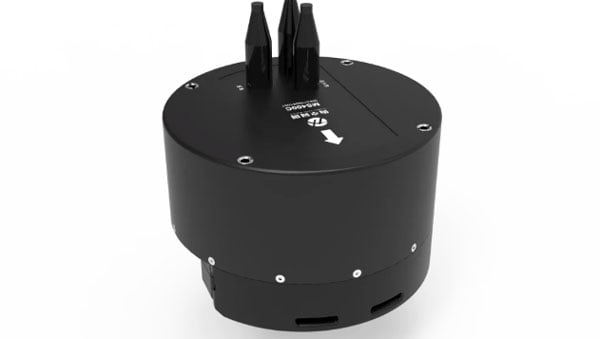
Localization Solution Operates in GNSS-denied environments
Photo: OxTS
WayFinder is a localization solution designed for GNSS-denied environments. It integrates a GNSS/INS system, onboard processor, lidar scanner and two cameras, enabling precise navigation in areas with limited satellite coverage. The system features Lidar Boost, a software technology that enhances GNSS/INS performance by processing lidar data to compensate for missing or inaccurate GNSS updates in real time. This ensures high-accuracy localization and seamless transitions between GNSS-supported and GNSS-denied environments.
WayFinder enables precise navigation for autonomous vehicles in ports, mining and indoor automotive testing without fixed infrastructure. It also provides reliable positioning for surveyors in areas with limited GNSS coverage.
Virtual Surveyor Version 10 introduces Basic Topographic Design tools, allowing users to document terrain changes such as graded roads, water ponds and building surfaces. The software now features four subscription plans — Valley, Ridge, Mountain and Peak.
Ridge plan: Focuses on surveying a single moment in time using one drone data set.
Mountain plan: Adds Timelines to compare surveys across different times, visualizing changes through Time Steps.
Peak plan: Includes advanced Topographic Design tools for planning future structures by creating new Time Steps. These tools allow users to design features such as roads or ponds directly on UAV-derived models, with automated alignment and volume calculations for cut-and-fill operations.
Version 10 introduces drawing guides, available in the Ridge plan and above, enabling precise drawing of points at specific intervals or angles. Walk Mode, included in all plans, allows users to explore 3D terrain at ground level for better visualization. Timelines, featured in the Mountain and Peak plans, facilitate the comparison of multiple surveys conducted at different times and the integration of future designs. These improvements seek to streamline processes for engineering surveyors, supporting applications in construction, mining and water management.
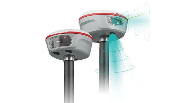
The Jupiter Laser RTK integrates GNSS, auto-IMU, laser and dual camera systems into a single unit. It incorporates a precise green laser that remains visible even in bright daylight. This feature allows for precise measurements of points in hard-to-reach, signal-blocked or potentially hazardous locations. It also features a night vision camera, allowing users to see feature points even in low-light conditions. The RTK system’s laser range is up to 50 m, making it suitable for challenging surveying environments. It incorporates visual technology to offer surveyors an immersive experience during surveying and stakeout operations, improving working efficiency and productivity.
Version 2.1.0 of AgEagle Aerial Systems’ eBee VISION application software introduces circular and grid mapping features, allowing users to generate 2D or 3D maps using external post-processing software for more comprehensive geospatial data.
The eBee VISION 2.1.0 can continue missions in GNSS-denied environments and allows manual deactivation of GNSS to prevent jamming or spoofing. It implements the STANAG 4609 standard, the official format for motion imagery exchange within the NATO nations. This involves embedding UAV position and camera information into the videos recorded by the UAV and those broadcasted by the Ground Control Station. Its inclusion in the system seeks to enhance interoperability with third-party applications, which is key for military-grade UAVs.
It offers enhanced control over the Silent Tactical Landing feature. Users can now manually adjust the landing position on the map, with the system providing range estimates to inform operators of the UAV’s reach. This functionality offers greater flexibility in mission planning and execution, particularly in tactical scenarios requiring precise landing control. The system is ideal for defense, public safety and utilities applications.
‘Drone-in-a-Box’ Solution Designed for vehicle-mounted deployments
Photo: DJI
The DJI Dock 3 “drone-in-a-box” solution is designed for vehicle-mounted deployments and 24/7 remote operations in various environments. This system is compatible with the Matrice 4D and Matrice 4TD UAVs, which feature advanced cameras and IP-rated protection for challenging conditions. The UAVs are ideal for public safety, emergency response and infrastructure inspection.
This system supports flexible deployment options, including vehicle-mounted setups optimized for emergency operations and long-distance inspections. It enables horizontal calibration and cloud-based dock location adjustments. Two docks can be mounted on a single vehicle to facilitate dual-UAV rotations for enhanced efficiency. In fixed deployments, the D-RTK 3 Relay Fixed Deployment Version can be added to improve video transmission and satellite connectivity.
The Matrice 4D and 4TD UAVs have a wide-angle camera, medium tele camera, tele camera and laser range finder. The Matrice 4D features an advanced camera suite designed for high-precision mapping. The Matrice 4TD includes an infrared thermal camera for public safety and emergency response applications. The system includes a Flight Termination System to support regulatory compliance in strictly controlled airspace. This system can manually or automatically stop drone operations if necessary.
Casia G Release 4.0 is a software update that enables nighttime detection of aircraft, allowing 24/7 beyond visual line of sight (BVLOS) UAS operations. The update supports BVLOS flights up to 400 ft at night without requiring hardware modifications, offering detection of both cooperative and non-cooperative aircraft. The system detects aircraft at distances of up to 16.7 km with 360° coverage, ensuring safe nighttime operations. When multiple units are used, triangulation technology provides accurate range, altitude and satellite data for intruding aircraft. The update leverages existing hardware to detect navigation and anti-collision lights at night.
The MAS10 is a 77 GHz FMCW marine radar system designed to enhance navigation safety in congested environments under all weather conditions. The ultra-high-definition W-band radar provides centimeter-level resolution, enabling vessels to detect and identify small hazards in heavily trafficked waterways.
Unlike optical and infrared sensors, W-band radar technology penetrates fog, heavy rain and snow, ensuring reliable detection. It operates effectively in low-visibility scenarios, including complete darkness, intense sunlight and shadowed areas where cameras and lidar may struggle.
The Eagle Series line of spatial 3D scanners feature lidar and imaging sensors and are designed for various applications, including reverse engineering, digital twinning, asset management, extended reality, precision mapping and 3D printing.
The series offers scanning capabilities with a range of up to 140 m and precision within 2 cm at 10 m. The lightweight scanner is designed for portability, with a built-in battery providing up to one hour of continuous use.
The scanners are available in Standard and Max versions. The Max model features four 48 MP cameras, enhancing scanning efficiency and producing vivid 8 K panoramic photos. With a point cloud frequency of 200,000 points per second, the Eagle Series is designed for applications requiring highly detailed spatial data.
Upgraded Mapping Package With Google Maps downloads
Photo: Golden Software
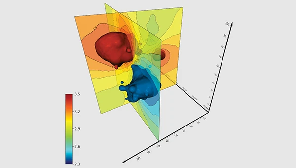
Golden Software has upgraded its Surfer mapping and 3D visualization software. Users can now directly download georeferenced aerial and satellite imagery from Google Maps into projects. The latest version also improves 3D visualization tools, focusing on faster and more intuitive creation of visual models. Users can now colorize 3D drill hole intervals based on text keywords, making it easier to interpret subsurface data. Additionally, contour slices can now be added to the 3D view, offering a clearer representation of data layers.
Golden Software has released a beta version (30.0.135) that introduces multiple light sources for improved 3D viewing and customizable legends for better map presentation. These updates are designed to streamline workflows for professionals in industries such as environmental consulting, resource exploration and geospatial analysis, simplifying the creation of professional-grade maps and models efficiently.