Advanced Navigation, an Australia-based company, is expanding its presence in the United States by actively recruiting military veterans. The company aims to leverage the unique expertise of former service members to enhance its mission-critical technologies and address the growing demand for assured positioning, navigation and timing (APNT) capabilities across defense, aerospace and critical infrastructure sectors.
Wayne Prender, former U.S. Army captain and head of global defense at Advanced Navigation, believes warfighters-turned-technologists are central to this mission.
“Veterans bring more than technical expertise; they understand firsthand the urgency and complexities of navigation in contested spaces. Their experience directly informs how we design, test and implement solutions, delivering capabilities that genuinely enhance mission outcomes and warfighter safety,” said Prender.
The company recruits veterans with operational backgrounds in submarines, special operations, aviation and electronic warfare to apply their expertise to APNT applications — including unmanned systems, advanced radar, precision strike platforms and secure battlefield communications. Advanced Navigation’s veteran-led business development team collaborates closely with system integrators, program offices and military end users to deliver tailored APNT solutions that meet rigorous performance standards.
NV5 is celebrating two decades of delivering critical geospatial services to the National Oceanic and Atmospheric Administration (NOAA).
For the past 20 years, NV5 has completed more than 220 contracts across 30 states, covering more than 50,000 square miles. These projects involve topobathymetric surface modeling of shorelines, bays, estuaries, lakes, wetlands, rivers and streams to provide detailed data for various applications. The information generated helps NOAA protect and restore natural resources and habitats, update nautical charts and understand the effects of environmental and human-induced changes over time.
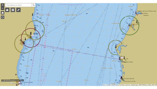
A screenshot from the NOAA ENC Viewer of the updated nautical chart of southern Lake Michigan, created using multibeam bathymetry and backscatter data. (Photo: NOAA)
The company employs airborne remote sensing technologies, such as topobathymetric laser scanning, to capture near real-time changes in nearshore topography and bathymetry. Additionally, NV5 integrates marine vessel-based technologies, such as multibeam echo sounding, to map offshore bathymetry, including sand resources, essential fish habitats and historic shipwrecks.
“Our collaborations with NOAA over the past 20 years have yielded many important insights and baseline data that helps the agency with its core mission of climate monitoring, coastal restoration and supporting marine commerce – all of which supports our nation’s economic vitality and affects more than one-third of America’s gross domestic product,” Dave Bernstein, vice president of hydrospatial operations at NV5, said.
The National Geodetic Survey Remote Sensing Division’s Coastal Mapping Program requires the collection of airborne topographic/bathymetric lidar and digital camera imagery data to enable accurate and consistent measurement of the national shoreline following Hurricane Sandy’s landfall. (Photo: NV5)
In one notable project, NV5 conducted a large-scale hydrographic survey in southern Lake Michigan for NOAA’s Office of Coast Survey. The survey covered 481 square nautical miles from northeast Chicago to Michigan City, Indiana — an area that had not been surveyed since the late 1940s. Using multibeam bathymetry and backscatter data, NV5 updated NOAA nautical charting products to improve maritime safety along the Michigan, Indiana and Illinois shorelines. Under NOAA’s Office for Coastal Management contract, NV5 also provided certified hydrographer expertise aboard the Pisces (R226), a NOAA fisheries research vessel. These efforts included overseeing the collection and processing of hydrographic data for marine habitat mapping.
A view looking south at the Submarine Canyon on Asan Point, Guam. The image was created from the lidar bare earth model and lidar point cloud colored by elevation and RGB values from imagery respectively. (Photo: Partnership between NV5 and Woolpert)
NV5 has also contributed to NOAA’s Coastal Change Analysis Program through projects that utilized aerial multispectral imagery and machine learning techniques. In Rhode Island, NV5 partnered with the National Estuarine Research Reserve System to study salt marsh habitats and produce change mapping products.
A view looking northeast from Virginia Key shows the topobathymetric surface of the intertidal zone near Fisher Island, Florida. (Photo: Nicholas Klein / iStock / Getty Images Plus / Getty Images)
Similarly, high-resolution land cover products were created for Brown County, Wisconsin, and key watersheds to assess urban growth, map wetlands, delineate wildlife habitats and monitor land cover changes over time. Other initiatives include mapping eelgrass habitats along coastal Massachusetts using multispectral aerial imagery and analyzing satellite imagery for wetland changes in the Great Lakes region.
Through these diverse projects, NV5 continues to provide NOAA with essential geospatial data that supports its mission of environmental stewardship and maritime safety while contributing to national economic vitality.
Swift Navigation‘s Skylark Precise Positioning Service now offers continuous two-centimeter accuracy across Western Europe, enabling the deployment of reliable consumer robots and digital mapping solutions.
Autonomous robots and field mapping applications require precise positioning to operate efficiently; traditional RTK solutions can often struggle, forcing robotics manufacturers to use local base stations or fragmented networks, which can lead to coverage gaps and inconsistent performance. Field teams in utilities and construction also require survey-grade accuracy without the high costs of professional equipment.
Skylark addresses these issues by delivering accuracy across geographic areas, eliminating the need for base stations or switching between providers. Skylark uses a proprietary atmospheric model that compensates for ionospheric and tropospheric effects in real-time. The carrier-grade network, operated by mobile network providers, ensures reliability across regions.
Skylark is available in three variants — Nx RTK, Cx, and Dx — designed to meet varying requirements for accuracy, power consumption, data transmission and cost. The Skylark Nx RTK delivers one-to-two centimeter accuracy across 28 countries in Western Europe and seven countries in Eastern Europe. Compatible with standard RTK receivers and supported by portals for credential management, licensing and usage analytics, Skylark Nx RTK integrates high-precision positioning into existing devices and workflows.
STMicroelectronics has partnered with Segway to enhance its latest range of robotic lawnmowers. The collaboration integrates precision positioning and extended satellite-signal coverage, designed to improve operational efficiency and safety.
Reliable satellite navigation is essential for robotic lawnmowers that operate without boundary wires. These devices must autonomously navigate safely, even in areas where tall buildings or trees obstruct satellite signals. Uninterrupted satellite signal coverage is critical for functioning at the edge of stairs or steep slopes.
STMicroelectronics’ Teseo satellite navigation chips — with automotive-grade quality and reliability — are well-suited for robotic lawnmowers. These chips enable decimeter-level location accuracy, ensuring the mower remains within its designated field perimeter.
Segway’s recently launched Navimow X3 robotic lawnmowers incorporate ST’s Teseo V single-chip triple-band GNSS receivers. These receivers track multiple satellite constellations simultaneously, delivering superior performance in challenging environments. The real-time kinematic (RTK) technique further corrects satellite signal errors, ensuring stable operation in complex layouts such as properties with narrow passageways or multiple mowing zones. The company said that compared to earlier models, Segway reports a 20 to 30% increase in satellite signal coverage with ST’s technology.
Technical specifications include ST’s STA8135GA GNSS receiver from the Teseo V family. This automotive-qualified chip integrates triple-band positioning measurement and dead-reckoning features within a compact package. On-chip voltage regulators simplify power supply selection, further enhancing design efficiency.
Rx Networks has introduced TruePoint | FOCUS, a high-precision, cloud-based GNSS correction service that offers instantaneous centimeter-level accuracy for a variety of applications. This service is designed to address the needs of industries requiring real-time precision, such as micro-mobility, smart agriculture, robotics, UAVs, IoT and machine control.
TruePoint | FOCUS supports both Real-Time Kinematic (RTK) and PPP-RTK modes to offer flexibility and high performance. The RTK mode is hardware-agnostic, ensuring compatibility with any RTK-enabled GNSS receiver. It uses standard correction protocols like RTCM v3 and supports access via NTRIP for seamless integration and rapid deployment. The PPP-RTK mode leverages State Space Representation (SSR) to deliver high-accuracy positioning with optimized bandwidth usage. This mode combines the benefits of global coverage from PPP with the fast convergence times of RTK, making it suitable for applications requiring seamless operation over large areas.
The service is notable for its ability to process more GNSS signals than many competing solutions, enhancing its resilience and performance in challenging environments. It supports signals from GPS, Galileo and BeiDou constellations, offering comprehensive correction capabilities. According to the company, TruePoint | FOCUS guarantees consistent centimeter-level accuracy with a 99.9% service level agreement, ensuring reliability for users operating in regions such as North America, Europe and China.
TruePoint | FOCUS is available for trial in both RTK and PPP-RTK modes across covered regions, with plans to expand its geographic reach. Interested users can request a complimentary 30-day trial license to evaluate the service.
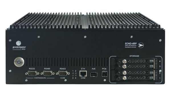
Syntony GNSS has introduced the Echo 4RP, the latest addition to its Echo series of GNSS record and playback systems. This new model builds on the capabilities of the Echo R&P, offering advanced features designed to address the evolving needs of GNSS testing and development.
The Echo 4RP expands its frequency range to include L, S, and C bands, surpassing the previous model’s coverage of 1100 MHz to 2550 MHz. This broader spectrum supports both current and emerging GNSS and non-GNSS signals, making it adaptable for diverse testing scenarios.
The system now supports up to four RF channels for simultaneous recording and playback, an increase from three in the earlier version. This enhancement enables complex testing setups, including multi-antenna configurations and Controlled Radiation Pattern Antenna (CRPA) applications, with precise phase synchronization.
The Echo 4RP delivers high-quality signal fidelity with options for 16-bit I&Q sampling at 93.75 MHz per channel or 8-bit I&Q sampling at 187.5 MHz per channel across all four channels simultaneously. These options provide flexibility to meet specific testing requirements.
Weighing less than 10 kilograms, the Echo 4RP combines portability with performance, making it suitable for both laboratory and field environments. Its compact design simplifies deployment without sacrificing functionality.
The system includes up to 32 terabytes of internal storage with a swappable SSD design, allowing extended recording sessions and efficient data handling.
The Echo 4RP is designed for a wide range of GNSS testing applications:
CRPA testing: Phase synchronization across all channels supports anti-jamming and anti-spoofing technologies for enhanced signal integrity.
GNSS spectrum analysis: C-band coverage allows exploration of new GNSS signals and services, aiding research into next-generation navigation technologies.
The U.S. Space Force’s Space Systems Command and Space Operations Command are preparing to launch the National Security Space Launch GPS III-7 mission, designated Space Vehicle 08, aboard a SpaceX Falcon 9 rocket. The launch is planned to take place from Space Launch Complex 40 at Cape Canaveral Space Force Station, Florida, no earlier than late May 2025.
This mission follows the successful Rapid Response Trailblazer launch in December 2024 and represents another accelerated effort. It involves a coordinated operation across multiple Space Force organizations to retrieve a GPS III satellite from storage, integrate it with the launch vehicle, and prepare it for launch on a compressed timeline.
The GPS III satellite is equipped with M-Code technology, which offers three times greater accuracy and eight times more resistance to jamming compared to earlier systems. This capability aims to enhance Precision, Navigation, and Timing services for the Joint Force, ensuring modernized support for military operations.
This effort builds on lessons learned from the previous Rapid Response Trailblazer mission and demonstrates the Space Force’s ability to reduce standard launch preparation timelines. While such preparations typically require up to 24 months, this mission is set to be completed within three months.
Mission Delta 31 of Space Operations Command is overseeing pre-launch processing in collaboration with Lockheed Martin in Colorado. On April 2, 2025, the satellite was transported to Florida aboard a U.S. Air Force C-17 Globemaster III and is now undergoing final preparations for launch. Col. Andrew Menschner, commander of Mission Delta 31, emphasized the teamwork involved in rapidly deploying an M-Code-capable satellite and advancing traditional launch timelines.
Key aspects of this mission include space vehicle-to-launch vehicle integration, satellite control preparation, and expedited contracting efforts.
The satellite is named in honor of Katherine Johnson, whose mathematical contributions were pivotal to early U.S. spaceflight missions. Once operational, it will enhance communication capabilities critical to national security and align with the Secretary of Defense’s strategic objectives by supporting military readiness with anti-jamming technology.
Septentrio, a division of Hexagon, has introduced two new products, the AsteRx RB3 GNSS receiver and the AsteRx RBi3 GNSS/INS system. These receivers are designed to operate in extreme environments, featuring IP69K-rated housings and components that have undergone rigorous ISO-standard testing.
The technologies robust construction ensures durability under heavy shocks, vibrations and challenging environmental conditions, making them suitable for demanding applications such as construction, mining and port automation.
The AsteRx RB3 and RBi3 utilize multi-frequency GNSS technology to deliver precise, centimeter-level positioning even in environments where GNSS signals are typically difficult to maintain. The receivers can be mounted externally on heavy machinery or integrated into chassis systems, offering flexibility in placement and simplifying installation.
The AsteRx RBi3 incorporates FUSE+ technology, which combines a high-performance GNSS engine with an industrial-grade inertial sensor. This integration provides accurate orientation data — such as heading, pitch and roll — alongside reliable positioning. In dual-antenna configurations, the receivers deliver sub-degree GNSS heading accuracy immediately upon initialization.
The AsteRx RB3 and RBi3 are ideal for machine guidance in industries requiring rugged equipment capable of maintaining precision under extreme conditions.
On March 27, 2025, the Federal Communications Commission (FCC) launched a proceeding on commercial technologies that would complement GPS. “Although GPS is indispensable to America’s economic and national security, it represents a single point of failure that can be vulnerable to disruption or manipulation by our adversaries,” said the FCC’s announcement, highlighting the federal government’s bipartisan call to develop complementary systems that provide positioning, navigation and timing (PNT) data to to better achieve PNT resilience nationwide and protect America’s economic and national security.
The Security Industry Association (SIA) commends the FCC’s commitment to protecting America’s economic and national security and exploring available PNT options. We believe the docket will show that there is a wide array of PNT technologies that can complement to GPS, and we look forward to providing information to the Commission about tradeoffs among these emerging PNT offerings and encouraging the Commission to avoid taking action that could disproportionately disrupt valuable public safety technologies.
One company, the for-profit entity NextNav, has petitioned the FCC to reconfigure the 902-928 MHz band (the Lower 900 MHz frequency) and grant it a nationwide license for 15 MHz of spectrum so it can establish a 5G terrestrial-based PNT network. NextNav also seeks the removal of the current requirement that it not cause unacceptable levels of interference to Part 15 devices. These devices include low-power, radio frequency (RF) devices ranging from consumer electronics and appliances to wireless alarm systems, smart home equipment, electronic access control devices and a wide range of devices used to increase economic productivity and efficiency, bolster safety, deliver innovation and provide other important benefits to consumers. This proposal has a dangerous likelihood of causing significant interference in the band that would be adverse to the public interest and threaten public safety.
The Lower 900 MHz band is vital for millions of security cameras, including popular models used in homes and small businesses. These devices are essential for protecting homes, preventing package theft and home intrusions, ensuring children’s safety and aiding law enforcement by capturing criminal activity. The changes proposed by NextNav would likely force these incumbent users into a shared portion of spectrum that is almost 60% smaller than the current Lower 900 MHz band — crowding that will cause many devices to stop operating reliably, compromising Americans’ safety and the security of our facilities and communities, and will be exacerbated by the growing concentration of devices using new technologies that require more spectrum bandwidth.
Another important service likely to be disrupted by the proposed band restructuring would be Z-Wave technologies. Z-Wave technology enables comprehensive home automation and security solutions —such as smart locks, thermostats and security systems — to integrate seamlessly with various smart home devices, while preserving advanced security features such as encrypted communication and secure inclusion. Z-Wave devices are not designed to withstand interference from fixed and/or mobile devices operating at commercial macro power limits and out-of-band emission limits, such as those in NextNav’s proposed high-power operations.
Additionally, millions of electronic access control and other wireless connected devices that are now in use in residential, institutional, commercial and government buildings across the United States would be impacted. The interference generated from NextNav’s higher-power communications would significantly impact the reliability of these important safety and security products and ecosystems, effectively making them unusable in the same spectrum.
In addition to these public safety and security uses, more critical systems that could be disrupted include:
Municipal infrastructure, including such systems as traffic control, street lighting, weather monitors and flood warning systems that are deployed in this band to make communities safer and more energy efficient.
Critical infrastructure, including utilities’ use of the band for remote monitoring and management of power, gas and water distribution networks.
Railroad operations and safety, including the Automatic Equipment Identification network that enables tracking of rail cars and equipment, as well as essential traffic control, sensors and other devices necessary for operational safety and efficiency.
Highway infrastructure and tolling, including the operation of electronic tolling systems, such as E-ZPass and other similar toll collection systems.
Retail, manufacturing and supply chain operations, including building control systems, tank and leak monitoring system and inventory control systems.
Agriculture solutions used for connecting modern farms’ Internet of Things devices and equipment to keep our farms connected.
As other concerned parties have pointed out, there are a number of existing backup GPS options available to establish a terrestrial PNT without any reallocation of spectrum. While a backup GPS system is ultimately necessary, the other solutions that would be much less disruptive. The tradeoffs required by implementing the NextNav proposal are simply not worth the risk to our nation’s security and safety.
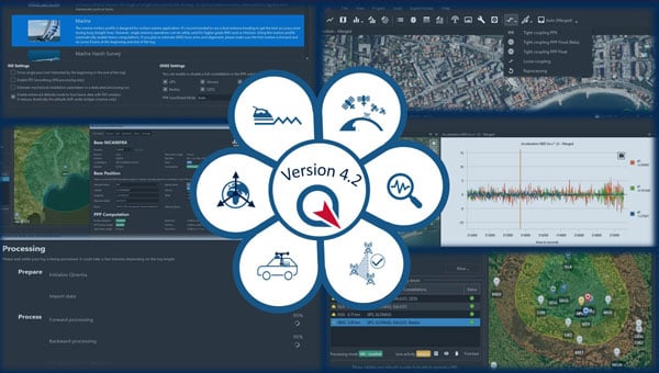
SBG Systems has released Qinertia 4.2, an updated version of its post-processing software for GNSS and inertial navigation system (INS) data. This release introduces several new features and improvements aimed at refining processing accuracy and usability, according to SBG Systems.
One of the notable additions is the beta version of Precise Point Positioning Fixed Ambiguity, which allows centimeter-level accuracy processing without the need for a base station. The update also includes a new RTS smoothing option, known as the Trajectory Smoother, which enhances INS processing by removing artifacts while maintaining precision. Another feature is the standalone Lever Arm Estimation Tool, now available as a separate application with a simplified interface. The Advanced Virtual Base Station Network Creation has been enhanced with improved base station quality indicators to increase reliability.
Other updates in Qinertia 4.2 include compatibility with the New Ellipse series and support for Teledyne Intrepid INS. The software now offers faster processing speeds, enhanced geodesy functionalities such as base station velocity analysis, and updated tools for assessing processing quality through new status plots. It also supports the latest firmware versions of Ekinox, Apogee, Navsight and Quanta systems.
These updates aim to improve workflow efficiency and data quality for professionals working with GNSS and INS systems.
ComNav’s Jupiter Laser RTK blends GNSS, IMU, laser and dual-camera tech for top accuracy and efficiency. It delivers immersive surveying and stakeout experiences, excelling in hard-to-reach, signal-blocked, or dangerous areas, boosting your work!
Click hereto learn more about the Juniper Laser RTK!
Thales Alenia Space — a joint venture between Thales and Leonardo — has secured a €51 million ($56 million) contract from the European Union Agency for the Space Programme (EUSPA) to extend the operational life of the European Satellite-Based Augmentation System (EGNOS).
Named Life Extension Phase 1 (LIFEX), this contract will ensure that EGNOS V2 continues to provide reliable, secure and high-performance navigation services for Europe’s aviation, maritime, land transport, mapping and agricultural sectors beyond 2028.
EGNOS system is designed to enhance the accuracy, reliability and integrity of positioning signals by improving the performance of GNSS, such as GPS and, in the future, Galileo. As part of this contract, Thales Alenia Space will address EGNOS V2 critical system upgrades and infrastructure improvements, reinforcing the system’s resilience and operational durability. These updates will focus on enhancing security measures, modernizing components, and ensuring the ongoing reliability of EGNOS’s Safety of Life Service, which plays a key role in aviation, enabling accurate approaches at European airports without requiring ground guidance systems. Operational since 2011, this service has significantly improved operational safety and efficiency for the greater benefit of European operators.