“This partnership draws on the strengths of both organizations,” said GPSIA Executive Director Lisa Dyer. “Positioning and navigation are critical to today’s automotive industry and the millions of workers and families who depend on vehicles for work, to transport their loved ones and to connect with the world around them. Future positioning and navigation satellite systems operated from low-Earth orbit will be key enablers for connected vehicles.”
GPSIA’s network now includes 13 national organizations and industry leaders, such as John Deere, Garmin, Trimble, Apple, Lockheed Martin and TrustPoint. The Alliance for Automotive Innovation brings deep expertise in the automotive sector and a strong commitment to advancing safer, smarter personal transportation technology. This addition aims to strengthen GPSIA’s commitment to fostering innovation, creativity, and entrepreneurship in GNSS and related space-based position, navigation and timing (PNT) technologies.
Iridium Communications is exploring the potential use of small satellites to demonstrate advanced positioning, navigation and timing (PNT) capabilities.
Iridium CEO Matt Desch discussed this initiative during the Smallsat Symposium in Silicon Valley, where he suggested the company might venture into the smallsat business, even if only for experimental purposes.
Desch said small satellites could also support the development of a very-high frequency (VHF) radio system aimed at enhancing pilot communications with Aireon, a provider of aircraft surveillance services using hosted payloads on Iridium’s satellites.
Iridium operates a constellation of 66 Iridium Next spacecraft in low-Earth orbit (LEO) for L-band connectivity services, along with additional spare satellites. Following an engineering assessment in 2024, the company expects this constellation to remain operational until at least 2035.
The Iridium Next satellites, weighing approximately 860 kg, are significantly larger than typical small satellites used for LEO communications, which generally range from a few dozen to a few hundred kilograms. While smaller satellites offer advantages in terms of faster and more cost-effective deployment for specific missions, Iridium’s larger satellites are designed for extended operational life, supporting its global, cross-linked network.
The European Union Agency for Space Programme (EUSPA) has released its first GNSS and secure satellite communications (SATCOM) user technology report, offering an overview of recent developments in GNSS and SATCOM. This publication combines and expands upon previous GNSS user technology and secure SATCOM market and user technology reports, offering a comprehensive look at current trends and advancements in user technology.
The report examines the satellite industry’s ongoing transformation, influenced by evolving security concerns, increased digitalization efforts, rapid progress in artificial intelligence (AI) and the emergence of the New Space sector. By addressing these topics, the report aims to provide stakeholders with up-to-date information on the state of satellite-based technologies.
Focusing on both GNSS and Secure SATCOM, the publication explores recent innovations in user technology, such as terminals and receivers. It also investigates potential synergies between these two fields. This approach allows readers to gain insights into how these technologies are developing in parallel and potentially converging in certain applications.
Developments and trends in GNSS technology
The report opens with a summary of the recent developments and future trends in GNSS technology that are relevant to end users. As new GNSS frequencies and signals become available for civilian applications, receiver manufacturers have been upgrading their products to accommodate satellites in medium-Earth orbit (MEO). The international coordination among GNSS supports this advancement, Radio Navigation Satellite Service, and Satellite-Based Augmentation System providers, resulting in the adoption of open access signals with compatible frequency plans, common multiple access schemes and modulation schemes.
The report states that a service-oriented approach to GNSS is emerging, building upon existing infrastructure to offer users enhanced performance and security. The European GNSS program has made significant strides in this area, backed by the recent implementation of the Galileo High Accuracy Service (HAS) and Open Service Navigation Message Authentication (OSNMA) feature. The Report gives insight into emerging technologies and upcoming innovations, focusing on key trends in receiver electronics design and signal processing aimed at improving performance or reducing power consumption. Multi-frequency capabilities, PNT processing strategies and advances in antenna design are identified as key drivers shaping the future of GNSS receiver technology, according to EUSPA.
Among other topics selected, the spoofing and jamming threats are becoming a priority to be addressed both at the system and user level. Solutions such as Galileo OSNMA authentication and more resilient receivers with multiple antennas and sensor hybridization are being explored and are starting to be implemented.
Developing secure SATCOM systems
The secure SATCOM section of the Report outlines trends in the secure SATCOM domain by emphasizing enhanced performance and system management optimization. It specifically highlights how digitalization processes, cloud environments and AI techniques are enhancing performance and system management optimization in the secure SATCOM domain. It also notes the ongoing efforts to standardize the integration of non-terrestrial networks into the 5G ecosystem.
According to EUSPA, the deployment of large Non-Geostationary Orbit (NGSO) constellations aims to improve performance, particularly in reducing transmission latency. These systems rely on advanced user terminals capable of tracking and switching between multiple fast-moving satellites across the sky.
The report also emphasizes security in SATCOM transmissions, recognizing that satellite communications encounter similar threats from malicious signals as terrestrial communications. Consequently, both governmental and commercial SATCOM systems are being developed with a rising focus on enhancing the confidentiality, integrity, and availability of both governmental and commercial SATCOM systems links.
It also describes a shift in SATCOM systems from legacy hardware-centric designs to modern software-oriented solutions. This digital transition allows user terminals to utilize multiple constellations and frequencies, which significantly improves the availability of communication links. This can help mitigate disruptions caused by natural factors or intentional interference.
Exploring potential and existing synergies
The report concludes with an examination of existing synergies between GNSS, secure SATCOM, and Earth observation (EO). Notable examples include the transmission of EO data through SATCOM systems, utilizing GNSS for operating NGSO SATCOM terminals, the complementary use of GNSS and secure SATCOM in transport and emergency management, remote sensors used by Copernicus — a European EO program — that rely on both GNSS and SATCOM and high-accuracy GNSS positioning in remote areas enabled by SATCOM.
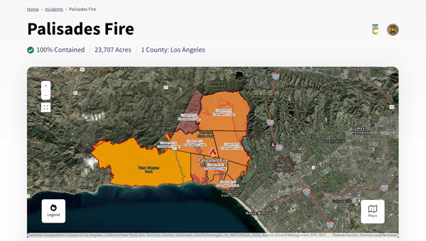
The Palisades and Eaton fires devastated parts of Los Angeles in January 2025 and are largely contained as of Jan. 20. Fueled by extreme Santa Ana winds and dry conditions, these fires have left a mark on the region’s landscape and community.
The Palisades Fire, which originated in the Pacific Palisades on Jan. 7, ultimately burned 23,448 acres, resulted in 12 confirmed fatalities and destroyed or damaged more than 6,800 structures, according to the California Department of Forestry and Fire Protection, known as CAL FIRE. The fire’s rapid expansion was particularly alarming, growing from a small brush fire to a massive conflagration within an hour.
Simultaneously, the Eaton Fire, which began near Altadena and Pasadena, consumed 14,117 acres. This fire proved even more deadly, with 17 confirmed fatalities and significant damage to more than 10,000 structures, according to CAL FIRE. Both the Palisades and Eaton fires have now been classified among the most destructive wildfires in California’s history.
During times of emergency, geographic information systems (GIS) specialists come together to create real-time mapping tools to provide critical support to first responders and keep communities well-informed. These tools have become indispensable in modern disaster management, particularly in wildfire response.
Interactive 3D Maps
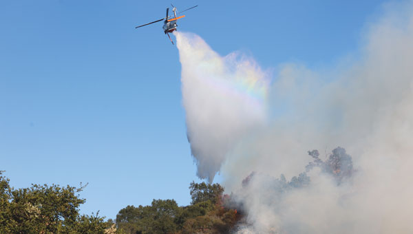
Firefighters and other specialists from federal, state, and local agencies work together to fight wildfires. GIS specialists develop interactive 3D maps to display fire perimeters, evacuation zones and other critical data. The geospatial data serves as the foundation for effective communication and decision-making, allowing firefighters and incident management teams to access information in near real-time to make informed decisions.
Fire GIS specialists Peter Rowland, Brett Adler and Dawn Hutchinson shared insights into their teams’ strategies for wildfire management. They emphasize the crucial role of geospatial tools in disaster response by delivering actionable intelligence. GPS World interviewed them during the California wildfires. Rowland and Adler were based at the Palisades fire, while Hutchinson, who is a member of a California Interagency Incident Management Team (CIIMT), was located near the Eaton fire.
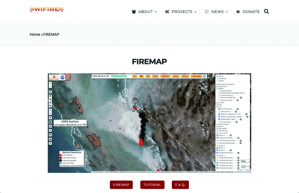
Interagency GIS teams use the Fire Integrated Real-Time Intelligence System (FIRIS) to watch for fire starts and then receive alerts from dispatch centers and satellite imagery. After locating the point of ignition, they create fire behavior models using a program called WIFIRE from UC San Diego. This tool allows them to predict the fire’s probable trajectory and size.
Photo: CAL FIRE
The team will alert the state if the data shows the fire is likely to spread. Hutchinson explains that, within minutes of the start of the Eaton fire, her team produced a fire behavior model that illustrated where the fire was most likely to go and how big it would likely get within the next three hours.
Photo: CAL FIRE
The frequency of IR flights depends on the fire’s size and intensity. Occurring anywhere from once to three times daily, including nighttime, these flights comprehensively map the landscape based on the fire’s specific traits. The decision on how often to fly the planes and collect the IR data depends on the fire’s behavior and potential threat level.
Field observers are also deployed daily to collect data down to the debris. They walk the fire’s edge and move along specific paths created for wildfire management and containment. Once a fire is contained, GIS specialists try to verify ground truth for the perimeter of the entire fire.
GIS specialists constantly update fire perimeters as they get data from the field and the planes. Once a fire is contained, they create final maps to hand over to the local agencies or the Forest Service.
Photo: CAL FIRE
Most of the data that GIS specialists use to map fires comes from field observers and infrared (IR) thermal imagery. The data is collected by third-party contractors, by CAL FIRE’s Intel shift team, or by the FIRIS program by flying manned aircraft.
IR data and information collected by field observers are then uploaded into the National Incident Feature Service (NIFS) for GIS specialists to use to map fires.
Field observers download the maps onto their devices, go out into the field, and ground truth — physically walking the perimeter of the fire and using GPS on their devices to map the fire boundaries accurately.
Photo: CAL FIRE
Paper maps are good to have “just to get everybody on the same page without having to worry about battery life or the glare while you’re working out in the field,” said Rowland.
Along with online maps, the Interagency GIS teams print PDF maps for fire personnel in the field. The field observers use Esri ArcGIS Field Maps to record their tracks. They pair their mobile devices with Avenza or other geolocating applications.
Using ArcGIS Pro, GIS specialists create online maps and dashboards, which are then distributed in print and/or digitally to the agencies that need them, such as sheriff and police departments and departments of public works. The Interagency GIS teams create different map products for different end users. For example, it works with law enforcement to create evacuation maps and zones. Local public information officers also can distribute these maps or post them on their websites.
Photo: CAL FIRE
Crews also have online access to the maps through wildfire FTP (ftp.wildfire.gov). Crews load data and maps there that contain public information. Many agencies plug into the National Interagency Fire Center (NIFC), where the CAL FIRE team edits and analyzes mobile data.
Adtran has launched its Enhanced Short-Term Unit (ESTU) precision timing module for its OSA 3300 series optical cesium clocks.
The module is designed to meet the demands of industries requiring ultra-stable short-term timing. According to the company, the module can achieve performance levels comparable to the passive hydrogen maser, which is no longer available in the Western market.
The ESTU module improves short-term frequency stability, measured through Allan Deviation, a key metric for timing accuracy. This improvement is particularly valuable for sectors such as metrology, space exploration and defense, where precise synchronization is crucial for data collection, satellite communication and measurement operations. Designed to optimize short-term frequency stability, the ESTU module is a versatile addition to Adtran’s Oscilloquartz synchronization technologies. It supports both 5MHz and 10MHz output frequencies, making it suitable for a wide range of high-precision applications, including those that previously relied on passive hydrogen masers.
Savvy Navvy has released Savvy Integrated, a comprehensive hardware and software integration platform specifically designed to provide advanced navigation solutions for original equipment manufacturers (OEMs) in the marine industry. This solution combines digital charting technology with hardware integration capabilities, addressing critical navigation challenges for boat manufacturers.
The Savvy Integrated platform provides OEMs with a navigation solution featuring a comprehensive digital marine chart with real-time geographical data and seamless integration with multifunction displays. The platform, which is compatible with a range of marine system architectures, offers extensive depth mapping and navigation details, as well as support for various types and configurations of vessels.
From Dec. 4-5, 2024, the National Space-Based Positioning, Navigation and Timing (PNT) Advisory Board met to discuss GPS-related topics. The PNT Advisory Board provides independent advice to the U.S. government on GPS-related policy, planning, program management and funding profiles in relation to the current state of national and international satellite navigation services. A March 28, 2024, GPS World article by Dana Goward highlighted that the PNT Advisory Board has been providing the government with independent expert advice about GPS and PNT for 20 years. He highlighted that the Board is chaired by retired Admiral Thad Allen and has six subcommittees.
This newsletter will highlight a topic that the emerging capabilities, applications and sectors subcommittee discussed at the final PNT Advisory Board meeting of 2024. The presentation title is “GPS High Accuracy and Robustness Service (HARS).” A white paper on the topic and the Dec. 4, 2024, presentation by Shachak Pe’eri, Ph.D., NOAA/NOS/National Geodetic Survey (NGS), can be found on the PNT Advisory Board website.
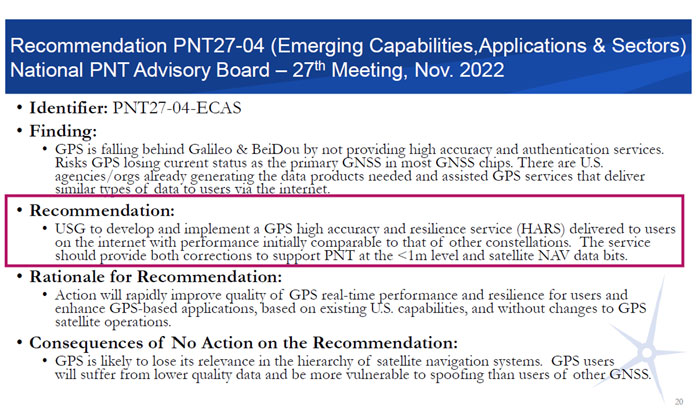
According to the document, the board prepared the white paper to support recommendation number PNT27-04-ECAS, which is to develop and implement a GPS HARS delivered to users via the Internet. The HARS concept was approved at the PNTAB-27 meeting (Nov. 16-17, 2022) and formally submitted to the National Space-Based PNT EXCOM co-chairs via Memorandum on Jan. 27, 2023.
Recommendation PNT27-04. (Photo: Presentation by John W. Betz, PhD Member, National Space‐Based PNT Advisory Board on May 29, 2024)
The November and December Advisory Board meetings are recorded, and individuals can listen to the entire meeting. The Board’s website provides links to the meeting agenda and presentations. Pe’eri’s presentation on HARS started at 10:30 am on Dec. 4 (2:04 on the recording).
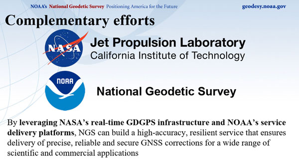
During the meeting, the PNT Advisory Board officially stated that it supports the HARS Concept described by NOAA. Of course, the Board also stated that it has no money, but the Board’s stamp of approval of the concept is very important. Now, it is up to NOAA’s NGS to work with other federal agencies, such as NASA’s Jet Propulsion Laboratory (JPL), to work out the details and resources. By leveraging NASA’s real-time Global Differential GPS (GDGPS) System infrastructure and NOAA’s service delivery platforms, a high-accuracy, resilient service that ensures delivery of precise, reliable and secure GNSS corrections for a wide range of scientific and commercial applications can be built for the nation.
So, what exactly is the GPS High Accuracy and Robustness Service (HARS)? The following is a statement from a Jan. 27, 2023, PNT Memo:
“Implementing a GPS High Accuracy and Robustness Service: To augment GPS and overcome some inherent limitations of space-based PNT, the USG should provide a service comparable to the European Union’s Galileo HAS that provides signal corrections than enable better than one-meter level accuracy, as well as cryptographically-protected satellite navigation message data bits for integrity processing. The U.S. should develop and implement GPS HARS, based on the capabilities developed by the JPL for GDGPS, to be made available to users over the Internet.”
The white paper describes the problem and the solution as the following:
“The problem: GPS is falling behind other Global Navigation Satellite Systems (GNSSs) such as Europe’s Galileo and China’s Beidou. GPS has adopted an approach of allowing augmentation by third-party systems (such as Assisted-GNSS in mobile phones, WAAS for aviation accuracy and integrity, and commercial RTK for precision users), rather than providing specialized advanced services itself. Also, the data message modulated on the GPS signals is fragile. Environmental effects or malicious actions can prevent a receiver from reading the information or manipulate what is read, limiting the robustness of the GPS signals. Currently, GPS is the primary system in almost all GNSS chips, even chips made in Europe or Asia. That is: chips are designed to acquire GPS signals first, then signals from other systems. But Galileo and BeiDou are deploying high accuracy services that provide sub-meter position accuracy, enhancing satnav use in many civil applications. The absence of any plan for GPS to offer a similarly high accuracy service could cause GNSS chips to begin using Galileo or BeiDou, rather than GPS, as the primary system. A switch away from GPS as the primary PNT system is a problem for the US Government because it will lose its strategic advantage. Existing commercial chips are used in many strategically important US assets, such as airlines, ships, and organizations that support the US military. Once these chips change their architecture to Galileo-first or BeiDou-first, these strategic use cases depend on these services. It is one step in the direction of not having a GNSS system at all and borrowing the system of another power, exactly the situation that Europe and China were in before they built their own systems. GPS would no longer be the “pre-eminent space-based PNT service” called for in Space Policy Directive 7.”
“The Solution:A high accuracy and robustness service (HARS) provides information to user receivers, reducing errors and enhancing the ability to operate in challenging conditions. The PNT Advisory Board has identified a solution that the U.S. government can provide a HARS without adding cost and complexity to GPS itself; instead, the needed information from government or government-sponsored organizations can be obtained and provided over the Internet to properly equipped receivers. The result would be a world-class HARS at a small fraction of the cost or time, compared to implementing it on new GPS satellites. The HARS would provide cryptographically-protected robust (resistant to jamming and spoofing) GPS for critical infrastructure and would enable new applications (such as lane-dependent route guidance in automobile navigation and emergency vehicle guidance, GPS-only precision positioning of drones) that extend the societal benefits of GPS. HARS would be secure and less sensitive to radio noise and disruptions, including spoofing.”
The following are a few slides from Pe’eri’s presentation highlighting the need for HARS. He mentioned that there are six regional high accuracy systems and one global service that is already operational or in development.
Six regional HAS and one global HAS are operational or in development at this time. (Photo: NOAA/NGS)
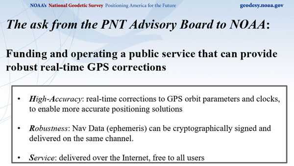
NOAA’s presentation by Pe’eri was in response to a request by the Advisory Board. The Board was interested in learning more about the funding and operating a public service that can provide robust real-time GPS corrections. Summarized in three bullets:
High-Accuracy: Real-time corrections to GPS orbit parameters and clocks to enable more accurate positioning solutions.
Robustness: Nav Data (ephemeris) can be cryptographically signed and delivered on the same channel.
Service: Delivered over the Internet and is free to all users.
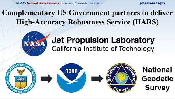
The HARS could be accomplished by employing the expertise, knowledge, and capabilities of NASA’s JPL and NOAA’s NGS.
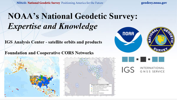
NOAA has the authority to provide real-time operational services and regularly collaborates with other federal and state agencies and local communities. NGS manages and distributes the NOAA CORS Network (Foundation and Cooperative CORS). NASA JPL collects GNSS data and generates products with high accuracy.
NGS expertise and knowledge. (Photo: NGS/NOAA)
NASA’s GDGPS is a complete, highly accurate and extremely robust real-time GNSS monitoring and augmentation system. The CCDIS website states, “Employing a large ground network of real-time reference receivers, innovative network architecture, and real-time data processing software, the GDGPS System provides sub-decimeter (<10 cm) positioning accuracy and sub-nanosecond time transfer accuracy anywhere in the world, on the ground, in the air, and in space, independent of local infrastructure.”
JPL expertise and knowledge. (Photo: NASA)
By leveraging NASA’s real-time GDGPS System infrastructure and NOAA’s service delivery platforms, NGS and JPL can build a high-accuracy, resilient service that ensures delivery of precise, reliable and secure GNSS corrections for a wide range of scientific and commercial applications.
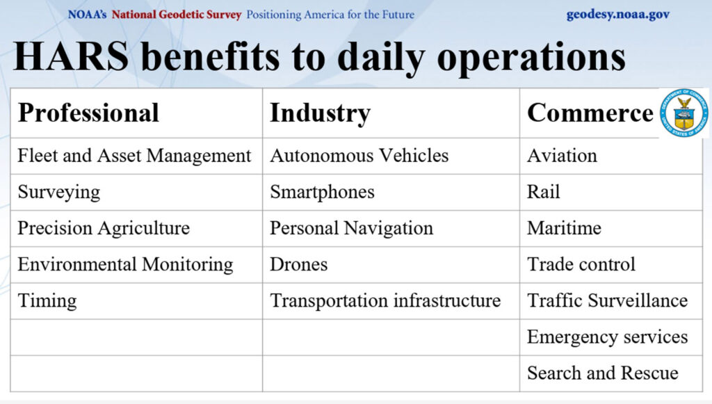
Pe’eri’s presentation highlighted HARS benefits to the daily operations of users of geospatial data.
HARS benefits for users. (Photo: NOAA/NGS)
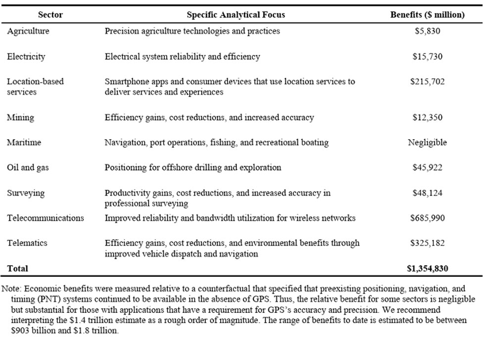
The HARS concept is extremely important to the U.S. GPS user community, where the number of users is increasing every day. A 2019 Department of Commerce (NIST) study, “Economic Benefits of the Global Positioning System (GPS),” highlighted the economic damages a GPS outage would have on the agricultural industry.
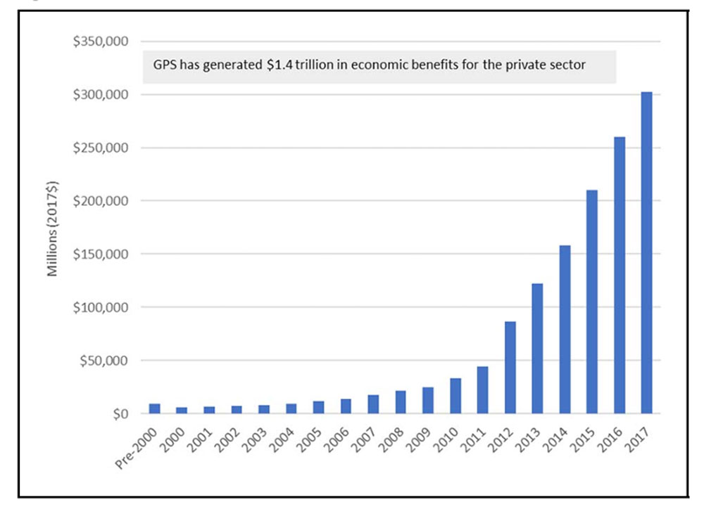
The 2019 NIST study, “Economic Benefits of the Global Positioning System (GPS),” determined that $1.4 trillion in U.S. economic benefits from GPS. The study stated that a 30-day widespread outage could erode less than $1 billion in economic value per day. The study also highlighted the impact a GPS outage would have on Agriculture, stating that during planting season, economic damages in the agriculture sector could increase 30-day losses to $15 billion due to lower yields.
Table ES-1 and figure ES-1 from the 2019 report highlight the economic benefits of GPS for private sector use.
Table ES-1: Summary of economic benefits of GPS for private-sector use, 1984 to 2017. (Photo: NIST) Figure ES-1: Time series of GPS’s economic benefits for the private sector. (Photo: NIST)
I would encourage others to look at the PNT website, especially the Advisory Board website, to obtain information about space-based PNT. Other recommendations and letters from the Advisory Board to the Executive Committee (EXCOM) can be found on the PNT and Advisory Board websites. The webpage provides the Advisory Board’s recommendations on ways to improve GPS and national GPS management. The recommendations are published in the interest of public transparency.
In response to the recent wildfires in Southern California, Topcon Positioning Systems is now offering free access to its GNSS correction services network for emergency recovery efforts. The company is offering a 90-day subscription to its Topnet Live service, which delivers precise positioning data crucial for assessing damaged infrastructure, surveying, utility mapping and operating construction equipment.
The technology is being made available at no cost within affected areas to support first responders, public works teams, and other professionals involved in damage assessment, infrastructure repairs, and rebuilding initiatives. The service is compatible with any brand of receiver capable of using RTCM format NTRIP corrections.
“We want to help the efforts that are ongoing and aid in the future reconstruction of the damaged communities from these wildfires,” said Jason Killpack, director of Topcon emerging business development. “The 90-day emergency subscription service is free to anybody that needs them to get their essential job done.”
Individuals or organizations seeking to activate this service can contact participating Topcon distributors in California. Contact information is available on the company’s website for those interested in utilizing the emergency assistance.
The European Union Agency for the Space Programme (EUSPA) has selected GMV to develop a new version of the High Accuracy Data Generator (HADG) as part of Phase 2 of the Galileo High Accuracy Service (HAS) development.
This service offers free real-time precise positioning corrections to all Galileo system users. The first version of the HADG, also developed by GMV, is currently operational and provides users with the Initial Service (Phase 1) of the HAS.
The new contract spans up to 45 months and has a budget of up to €12 million. It covers the design, development, deployment, and support to commissioning, along with optional maintenance of an enhanced version of the HADG. This updated version will integrate the functionalities necessary for providing the services outlined in Phase 2 (Full Service) of the HAS deployment.
The new version of the HAS data generator seeks to improve the performance level of Service Level 1 (SL1) by deploying a new version of GMV’s magicPPP algorithms for precise corrections calculation and expanding the ground station network. This aims to provide global coverage and enhance the accuracy and availability of the SL1 service. Additionally, it will implement a new Service Level 2 (SL2), a regional service available only in Europe that will transmit atmospheric corrections to reduce the convergence time required to achieve maximum accuracy at the user level.
Another key feature of the new HADG version is the implementation of a new functionality for the authentication of HAS corrections transmitted through the Galileo constellation, thereby increasing user security and confidence in the service.
Since 2020, GMV has led the development of the Galileo HAS data generator following the award of the first contract with EUSPA. Since its operational launch in January 2023, the Galileo HAS service has provided accuracy for advanced applications in sectors such as navigation, agriculture, geodesy, and autonomous driving. In the new contract, GMV maintains its role as the main contractor and leader of an industrial consortium that includes atmospheric modelling experts from the Polytechnic University of Catalonia (UPC) and cybersecurity specialists from Sidertia.
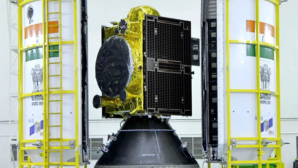
The Indian Space Research Organisation (ISRO) has encountered a significant setback with its recently launched NVS-02 navigation satellite. Launched on Jan. 28, 2025, the satellite is currently stranded in a transfer orbit due to a critical failure in its onboard propulsion system, ISRO stated in a report. The issue occurred when the valves admitting the oxidizer to fire the thrusters for orbit raising failed to open, which prevented the satellite from reaching its intended orbital position.
The NVS-02 satellite, part of India’s Navigation with Indian Constellation (NavIC) program, was launched using a Geosynchronous Satellite Launch Vehicle (GSLV) Mark II rocket from the Satish Dhawan Space Centre. The launch placed the satellite into a geostationary transfer orbit with a perigee of approximately 165 km and an apogee of approximately 37,582 km.
ISRO noted in its statement that other systems on the spacecraft were working well, including a successful deployment of its solar panels.
“The satellite systems are healthy and the satellite is currently in elliptical orbit. Alternate mission strategies for utilizing the satellite for navigation in an elliptical orbit are being worked out,” ISRO stated.
The space agency is now exploring alternative mission strategies to utilize the satellite for navigation in its current elliptical orbit. However, the low perigee of NVS-02 poses a significant risk, as it exposes the spacecraft to high atmospheric drag, potentially leading to an early reentry if the orbit cannot be raised.
NVS-02 is based on ISRO’s I-2K satellite bus, which has been used for other Indian communications and navigation satellites operating in geostationary orbit. The spacecraft had a launch mass of 2,250 kg.
The spacecraft was intended to operate at 111.75 degrees east in GEO, replacing the IRNSS-1E spacecraft there. It is the second of five satellites planned for India’s Navigation with Indian Constellation, or NavIC, program to provide positioning, navigation and timing services in India and the surrounding region. The first, NVS-01, launched in 2023 and operates in GEO.
Microchip Technology has introduced its second-generation Low-Noise Chip-Scale Atomic Clock (LN-CSAC), model SA65-LN. It features a lower profile height and operates in a wider temperature range, providing low-phase noise and atomic clock stability in challenging environments.
Chip-scale atomic clocks (CSACs) offer precise and stable timing in situations where traditional atomic clocks are impractical due to size or power constraints or where satellite-based references may be unreliable.
The SA65-LN, featuring Microchip’s Evacuated Miniature Crystal Oscillator (EMXO) technology, offers significant advancements in oscillator design. With a profile height of less than half an inch, power consumption under 295 mW, and an operating temperature range from −40°C to +80°C, this compact device delivers impressive performance. These enhanced specifications make the SA65-LN an ideal choice for a wide array of aerospace and defense applications. It is particularly well-suited for use in mobile radar systems, dismounted radios, IED jamming equipment, autonomous sensor networks, and unmanned vehicles, where size, power efficiency, and temperature resilience are crucial factors.
The LN-CSAC combines a crystal oscillator and an atomic clock in a single device, offering a low-phase noise of 10 Hz < −120 dBc/Hz, an Allan Deviation (ADEV) stability of < 1E-11 at 1-second averaging time, and an initial accuracy of ±0.5 ppb. The LN-CSAC also demonstrates frequency stability with a < 0.9 ppb/mo drift and maximum temperature-induced errors of < ±0.3ppb. These features contribute to high-quality signal integrity and atomic-level accuracy, potentially extending mission durations and reducing maintenance requirements.
“Seen & Heard” is a monthly feature of GPS World magazine, traveling the world to capture interesting and unusual news stories involving the GNSS/PNT industry.
Waymo opens autonomous rides in LA
Photo: Waymo
Waymo has launched its fully autonomous ride-hailing service in Los Angeles, available 24/7, following a waitlist of nearly 300,000 users before its rollout. The service covers nearly 80 square miles of Los Angeles County, including Santa Monica, Hollywood Boulevard and the University of Southern California. Waymo plans to expand its coverage as it scales its operations.
A large UAV show in Quanzhou, Fujian Province, China, ended in disaster when hundreds of UAVs crashed due to GNSS jamming. The event, intended to celebrate the city’s history with 2,000 UAVs equipped with low-altitude fireworks, faced significant disruptions when a camera drone entered the area without notifying authorities, leading them to mistakenly jam the signal. This incident resulted in an estimated loss of more than 10 million yuan ($1.4 million)
ISPRA project unveils coastal habitats of Italy
Photo: ISPRA
The PNRR MER A16-A18 project, led by the Italian Institute for Environmental Protection and Research (ISPRA), has released its first preliminary data for mapping Italian coastal habitats through the WebGIS Virgeo cartographic platform. The project focuses on mapping the growth of the Posidonia oceanica and Cymodocea nodosa meadows, which are crucial for biodiversity. Using high-resolution satellite imagery, lidar sensors and autonomous unmanned vehicles, the project is creating a comprehensive database for marine coastal ecosystem management and protection.
Celestial navigation system for UAVs
Photo: Cpl. Harrison Rakhshani
Researchers at the University of South Australia have developed a celestial navigation system for UAVs. The new system combines visual observations of the stars with standard autopilot technologies. In tests of the system using a fixed-wing UAV, researchers could pinpoint its position within 2.5 miles. This technology can be deployed by UAVs in GPS-compromised or denied areas by eliminating the need for GPS.