Author: Jesse Khalil

  • Europe moving toward a “timing backbone” and looking for input

    Europe moving toward a “timing backbone” and looking for input

    Citing a need for better “positioning, navigation and timing (PNT) resilience, availability and continuity,” a market consultation document from the EU’s Joint Research Center (JRC) says establishing a resilient PNT ecosystem is essential for “…EU autonomy, the economy’s overall resilience and EU global standing.” Therefore, creating this system-of-system ecosystem “… should be considered a critical priority for the EU.”

    Such an approach to PNT and resilience is a major feature of the 2023 European Radio Navigation Plan.

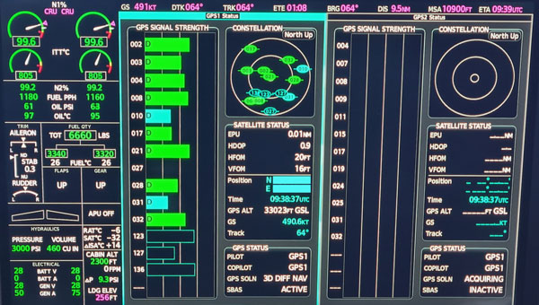
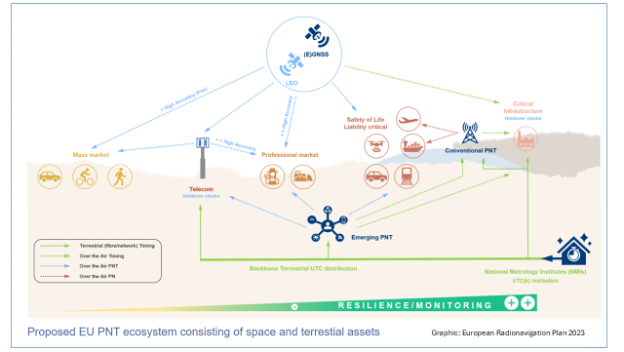
    According to the JRC, complementary (or continuous) PNT, or C-PNT, is the combination of existing space assets (GNSS) and future services that can work together in the multi-system ecosystem. This extends the service to areas where GNSS is not available and increases overall resilience.

    The JRC document goes on to say, “The first step towards the creation of such a C-PNT ecosystem is the deployment of the terrestrial timing backbone.”

    Such a backbone would:

    • Interconnect existing Member States (MS) National Metrological Institutes (NMI) and National Research and Education Networks (NREN) architectures into a pan-European network.
    • Maintain and (if possible) enhance the existing use cases (NMI, NREN and their existing commercial customers) and enable time connections to critical entities (CE), as regulated by the directive on the resilience of critical entities, while also promoting GNSS for additional resilience.
    •  Enable the commercial utilization of timing backbone to enhance EU competitiveness and enable further growth.

    Responsibility for navigation issues with the European Union is somewhat dispersed. The European Radio Navigation Plan is developed as a staff working document published by the European Commission’s Director General for Defense, Industry and Space (DG DEIFS). This directorate implements the EU Space Programme, which is, in turn, managed by EUSPA, an EU executive agency.

    At the same time the European Space Agency’s Navigation Directorate is responsible for “…positioning, navigation, and timing services of the European satellite navigation system Galileo and the augmentation system EGNOS” under agreement with EC. It is also responsible for ”…exploring future applications of navigation technologies for science and daily life.”

    This latter includes the Navigation Innovation and Support Program (NAVISP). And while space is an important consideration in NAVISP, the program has funded some decidedly non-space projects such as the UK’s MarRINav effort which focused on terrestrial PNT, and development of an eLoran antenna for handheld devices.

    The Joint Research Center supports a wide range of EU stakeholders for PNT efforts including DG DEFIS, ESA, member states, and pan-European organizations.

    A “market consultation” may not seem to many as an affirmative step toward establishing a timing backbone for Europe. Experienced observers, though, point to the wealth of documentation both ESA and DG DEFIS have produced on the need for PNT resilience and the benefits that will accrue to member nations.

    “The EU is very consultation and consensus-driven,” says timing expert Magnus Danielson at Net Insight. “So, you are not going to see the kind of top-down orders to do things as you might for a single state. Some of these decisions are made by each member state, as they should be. I am sure (European) Commission and ESA officials have seen what Sweden has done with distributed timing clocks operated by Netnoed, what the U.K. NPL is doing with its clock network, and are concerned about Russian jamming and spoofing in Ukraine and the Baltic. It’s pretty easy to connect the dots and make reinforcing PNT for Europe’s critical infrastructure and applications a priority. Working with the EC-JRC to develop this has been rewarding. Here’s hoping they move quickly enough. Several member states and friendly neighbors have already responded positively, and I sure the market consultation feedback will aid in moving decisions forward.”

    The concept of a system-of-systems approach to resilient PNT that is underpinned by network timing is not a new one. The 2008 U. S. National PNT Architecture articulated such an approach, though it was never implemented. In 2020 the RNT Foundation expanded on this idea in a paper advocating a U.S. national resilient timing architecture using signals from space, fiber, and terrestrial broadcast. China’s National Timing Service Center adopted a similar strategy. Media reports indicate China has completed or will soon complete its High Accuracy, Ground-based Timing System with 20,000km of fiber, 295 timing stations, and nation-wide eLoran service.

    The EU is asking for input about a European Timing Backbone and is interested in hearing from anyone, whether or not they are EU citizens.*

    Visit the EU Science Hub page before Dec. 9 and take the survey.

  • Alleged North Korea GPS jamming disrupts flights and ships in South Korea

    Alleged North Korea GPS jamming disrupts flights and ships in South Korea

    South Korea’s military has reported that North Korea disrupted GPS signals from border areas for the fifth consecutive day, impacting numerous civilian flights and maritime vessels. This interference originated from the western border cities of Kaesong and Haeju, North Korea.

    According to NBC News, the GPS jamming affected the West Sea (Yellow Sea) area. While the exact number of affected flights and vessels was not specified, the disruption was significant enough to prompt warnings from South Korea’s Joint Chiefs of Staff (JCS) to aircraft and ships operating near the western border.

    “We urge North Korea to stop GPS interference provocations immediately and strongly warn that it will be held fully accountable for any resulting consequences,” South Korea’s joint chiefs said in a statement.

    The incident occurs amidst escalating tensions between North and South Korea. It follows recent provocations by North Korea, including test-firing of advanced solid-fuel ICBMs, launching balloons carrying waste and propaganda into South Korea and allegations of North Korean troops being deployed to support Russia in Ukraine.

    Aviation specialists have expressed concerns about the risks posed by these jamming activities, including potential dangers to commercial airlines flying in poor visibility, complications in airline operations, and violation of international conventions on navigational safety.

    The GPS jamming is seen as part of North Korea’s electronic and psychological warfare tactics, highlighting the vulnerability of South Korea’s critical infrastructure, notably the Incheon International Airport.

    Experts warn that jamming attacks can lead to serious incidents, including potential aircraft accidents in worst-case scenarios. The ongoing situation underscores the complex security challenges in the Korean peninsula and the broader implications for regional navigation stability.

  • Xona Space Systems, QASCOM advance resilient PNT

    Xona Space Systems, QASCOM advance resilient PNT

    Xona Space Systems has partnered with QASCOM to integrate Xona PULSAR into QASCOM’s GNSS software-defined radio (SDR), the QN400-P. The integration is designed to strengthen positioning, navigation and timing (PNT) resiliency in the face of persistent threats.

    The partnership seeks to deliver security, jamming and spoofing resistance and next-gen accuracy for industries such as UAV navigation and defense.


    The QN400-P receiver offers multi-frequency, multi-constellation GNSS capabilities, including GPS and Galileo. Additionally, it includes measures for the mitigation of jamming and spoofing and is compatible with low-Earth orbit (LEO) PNT services, such as Xona’s PULSAR.

    The demand for more robust, secure and accurate navigation is increasing across various industries, including agriculture, construction and autonomous systems. The integration of Xona and QASCOM technologies aims to deliver solutions for these sectors, as well as for other relevant applications and use cases.

  • Aerodata AG secures EASA certification for GPS anti-jamming and spoofing technology

    Aerodata AG secures EASA certification for GPS anti-jamming and spoofing technology

    Aerodata AG has been granted a Supplemental Type Certificate (STC) by the European Union Aviation Safety Agency (EASA) for its advanced GPS anti-jamming and anti-spoofing solution. The certification applies to installations integrated with Garmin 5000 avionics in a Cessna Citation Latitude jet.

    With the growing threat of GPS jamming and spoofing in both civil and military aviation, Aerodata has developed a robust solution to offer continuous GPS availability. As attacks on GPS systems continue to increase, this anti-jamming and anti-spoofing technology is crucial in maintaining safe and reliable aviation operations.


    Aerodata’s solution seeks to enhance its special mission capabilities, especially in Intelligence, Surveillance and Reconnaissance (ISR) missions and flight inspection, where continuous, highly accurate navigation is crucial.

    Aerodata’s GPS Anti-Jamming and Spoofing Solution also positions Aerodata to reduce the vulnerability of its unmanned solutions to GPS interference, ensuring operational integrity across a wide range of manned and unmanned platforms. The newly certified system has undergone comprehensive testing and validation, and Aerodata is working on extending its capabilities to other aircraft platforms, targeting both civil and military applications.

  • Highlights and insights from ION GNSS+ 2024

    Highlights and insights from ION GNSS+ 2024

    The GPS World team participated in ION GNSS+ 2024, held at the Hilton Baltimore Inner Harbor, Baltimore, from Sept. 16-20.

    The event showcased more than 400 technical presentations spanning six sectors, addressing commercial and policy dimensions and research advancements. GPS World had the opportunity to engage in a series of discussions and panels, including a plenary session full of stories of space, and of circumnavigating the globe in a sailboat using only paper charts, a compass, and a sextant to navigate.

    (Photo courtesy of ION)
    (Photo courtesy of ION)

    Bob Addiss, senior software engineer at CAST Navigation, demonstrated CAST’s latest GNSS simulation systems. CAST GNSS systems can be configured to simultaneously provide multiple constellation types on each antenna element, such as GPS (including Y-Code, SAASM, M-Code AES and MNSA), BeiDou and GLONASS.

    (Photo courtesy of ION)
    (Photo courtesy of ION)

    Joshua Morales, StarNav CEO, led a demonstration of cold start positioning and timing using a StarNav receiver and simulated Xona PULSAR signals. The receiver tracked up to 13 PULSAR satellites simultaneously, producing real-time signal tracking and PNT data with a Safran GSG-8 simulator. This demonstration showcased StarNav’s receiver capabilities for LEO satellite-based PNT.

    (Photo courtesy of ION)
    (Photo courtesy of ION)

    More than 1,000 in-person attendees explored the show floor, visiting 44 exhibits. They had the opportunity to network, engage with exhibitors and dive deeper into the latest products and trends in the industry.

  • Space Force’s new GPS satellites running months behind schedule

    Space Force’s new GPS satellites running months behind schedule

    The Pentagon’s first batch of new and more capable GPS satellites, part of the GPS IIIF program, is facing significant delays. The first batch is eight to eleven months behind schedule, which the U.S. Space Force attributed to manufacturing difficulties encountered by contractor Lockheed Martin, particularly with complex components necessary for the satellites’ operation. Originally expected to be available for launch in April 2026, the first satellite’s delivery has now been pushed to November 2026.

    The GPS IIIF program is a $9.2 billion initiative aimed at deploying up to 22 advanced satellites. The first ten satellites in this series are designed to enhance the GPS system with improved accuracy and jamming-resistant signals. These satellites will serve both critical defense applications, such as guiding smart bombs, and civilian uses, such as turn-by-turn navigation.

    The new F-model satellites promise increased navigation accuracy, a signal compatible with similar European satellites, greater resistance to cyberattacks and jamming and civilian search-and-rescue capabilities to detect and locate emergency beacons.

    “For the average driver using GPS navigation,” the new satellites will provide “enhanced route planning and navigation, reducing travel time and improving fuel efficiency” and a “consistent GPS service even in urban canyons and areas with tall buildings,” according to the Space Systems Command.

    According to the US Space Force, The primary obstacle appears to be the production of the Mission Data Unit, a crucial new component for improved navigation. Bloomberg reported that the subcontractor, L3Harris Technologies, manufactures this unit and is experiencing technical issues.

    Despite these setbacks, Lockheed Martin is reportedly on track to meet the contracted delivery dates, even if they miss the Space Force’s preferred “available for launch” schedule.

    Lockheed Martin’s fixed-price contract includes incentives for meeting schedules and keeping costs below U.S. targets. However, the Space Systems Command has indicated that some criteria have not been met, resulting in reduced profit for Lockheed Martin. The exact amount of lost payments has not been disclosed.

    The Space System Command notes that these delays occur against global inflation and supply chain challenges. While these factors have affected industries worldwide, the Space System Command emphasizes that Lockheed Martin, as the prime contractor, is responsible for managing all aspects of the GPS IIIF satellite development and production.

    The GPS IIIF program remains a critical component of the U.S. Space Force’s efforts to modernize the GPS constellation, ensuring its continued reliability and effectiveness for both military and civilian applications in the face of evolving global challenges.

  • Inertial Labs reveals lidar camera payload

    Inertial Labs reveals lidar camera payload

    Inertial Labs has introduced the RESEPI Ultra LITE, a lightweight payload combining lidar and camera technology for advanced surveying and mapping applications. The system integrates the XT-32 lidar scanner to offer users advanced data accuracy and point density across various operational modes.

    The RESEPI Ultra LITE has a compact design with a 5MP colorization camera, making it ideal for small unmanned aerial systems (SUAS) with strict volume constraints. It can be used for aerial and ground-based applications, including utility mapping, construction volumetrics, precision agriculture, forestry, site surveying and mining.

    Designed for seamless integration, the system is compatible with a wide range of platforms such as Freefly, WISPR, DJI, Sony and mobile setups. Inertial Labs’ proprietary SnapFit adapters ensure quick and secure mounting to enhance the system’s adaptability.

  • Astranis to develop resilient GPS satellites for USSF

    Astranis to develop resilient GPS satellites for USSF

    Astranis has been selected as one of four prime contractors for the U.S. Space Force (USSF) Space Systems Command’s (SSC) new Resilient GPS (R-GPS) program. This initiative aims to augment the existing GPS constellation with small, low-cost satellites to enhance resilience for both military and civil users. The program’s initial phase, Lite Evolving Augmented Proliferation (LEAP), aims to launch up to eight satellites by 2028.

    As part of this effort, Astranis has been awarded an $8 million contract for concept development. The company plans to leverage its expertise in manufacturing and operating low-cost, high-orbit satellites. Specifically, Astranis will utilize its MicroGEO satellite design and Octane Software-Defined Radio hardware to advance the R-GPS spacecraft design.

    The R-GPS program is characterized by a rapid development timeline. It utilizes the “Quick Start” authority, which allows for contract awards in under six months. Ultimately, the USSF envisions a proliferated fleet of over 20 small GPS satellites to enhance navigation and timing capabilities.

    These satellites will incorporate the latest GPS signals, including M-code, to offer optimal performance even in contested environments. In addition to Astranis, other contractors involved in the initial phase include Axient, L3Harris and Sierra Space.

  • Lidar helps uncover lost Mayan city

    Lidar helps uncover lost Mayan city

    A graduate student analyzing publicly available drone data in Mexico unexpectedly unveiled a vast ancient Mayan city hidden beneath a dense jungle in Campeche on the Gulf of Mexico. The findings, published in the academic journal Antiquity, reveal an extensive urban complex covering an area approximately one-and-a-half times the size of Washington, D.C.

    Luke Auld-Thomas, a Ph.D. candidate at Tulane University, stumbled upon this while browsing the internet, according to NBC News. The data, originally collected by a research group studying land-use patterns, was captured using UAV mapping technology and lidar. Auld-Thomas applied archaeological analysis methods to the survey data, leading to the identification of the ancient city.

    Unraveling the mystery

    The research team named the newly discovered city “Valeriana” after a nearby freshwater lagoon. This urban center consists of 6,674 structures, including pyramids reminiscent of those found at Chichén Itzá in Yucatan and Tikal in Guatemala. Valeriana likely housed between 30,000 and 50,000 inhabitants at its peak.

    Researchers believe Valeriana flourished during the Classic Maya period (AD 250 to 900) and likely collapsed between 800 A.D. and 1,000 A.D. The city’s decline is attributed to a complex set of factors, with climate change playing a significant role. Marcello Canuto, an anthropology professor at Tulane University, explained that climate variability caused stresses and adaptations, leading to systemic unrest in densely populated areas.

    Valeriana’s discovery highlights how surveys and lidar can be used in archaeological research. This newly adopted method uses laser pulses to penetrate forest canopies and capture detailed images of hidden landscapes. Canuto describes it as a form of “digital deforestation,” allowing researchers to uncover extensive, previously unseen layers of history in remote and inaccessible regions.

  • Royal Navy demonstrates quantum-sensing technology for alternative PNT

    Royal Navy demonstrates quantum-sensing technology for alternative PNT

    The Royal Navy has successfully tested a new quantum sensing technology designed for underwater detection. Conducted off the coast of Plymouth aboard HMS Magpie, the trials aimed to evaluate the effectiveness of this quantum-sensing system in identifying submerged objects.

    The technology leverages ultra-cold atoms to measure subtle variations in the Earth’s magnetic field, which indicate underwater objects. This method allows for the detection of items that traditional sonar systems might miss, enhancing the precision of underwater surveys.

    During the tests, the system identified various targets, including a concrete block weighing one ton, and demonstrated sensitivity sufficient enough to detect objects as small as a soccer ball.

    This project is part of a broader collaboration involving the Royal Navy, the Defense Science and Technology Laboratory (Dstl) and industry partners. It reflects ongoing efforts to integrate advanced technologies into naval operations, aligning with the UK’s strategic focus on quantum technologies.

    Future plans include further development and miniaturization of the quantum sensing system to enable its deployment on various naval platforms, such as ships and submarines, as well as autonomous underwater vehicles. The successful trials indicate that this technology could significantly improve the Royal Navy’s capabilities in maritime security and underwater exploration.

  • Ireland unveils Europe’s first verified GNSS data stream service

    Ireland unveils Europe’s first verified GNSS data stream service

    The National Standards Authority of Ireland’s National Metrology Laboratory (NSAI NML) has launched Europe’s first verified GPS/GNSS Data Stream (VGDS) service, designed to enhance the National Timing Grid of Ireland. This initiative, developed in collaboration with Timing Solutions, seeks to provide users with secure and reliable GNSS data.

    The VGDS service provides verified GNSS data via the Internet through Radio Technical Commission for Maritime Services (RTCM) packets. This allows users to verify their own GNSS data streams to mitigate risks such as jamming and spoofing. The service is crucial for various sectors, including government organizations, public institutions, communications, energy, transportation, financial services and cloud data centers, as it provides accurate time and location data.

    David Fleming, NSAI Technical Manager for Time and Frequency, emphasized the significance of this service, stating, “As Ireland’s digital economy continues to grow and more services and public safety aspects are dependent on GNSS/GPS data, the importance of verifiable GNSS/GPS data in Ireland is paramount.” The VGDS service aims to improve the resiliency of Critical Infrastructure sectors by providing safe GNSS/GPS data and signals.