Leica Geosystems, part of Hexagon, has released upgrades for its BLK2FLY autonomous flying laser scanner. The scanner captures building exteriors, interiors, structures and environments to create 3D point clouds while flying autonomously.
The Leica BLK2FLY is a semi-autonomous flying laser scanner ideal for architects, engineers and designers to capture the exterior features and dimensions of buildings and environments that would otherwise require a UAV with a lidar payload or a traditional photogrammetry UAV. To operate the BLK2FLY, a user makes a few simple taps on a tablet and the BLK2FLY captures a structure’s complete external dimensions, such as rooftops and facades, in the form of colorized 3D point clouds.
The BLK2FLY also features new scanning and two new indoor and outdoor scanning workflows. It also offers three different levels of scan quality based on environment and user needs. These levels include:
• Standard Quality: Ideal for large outdoor environments requiring the least amount of time. • High Quality: Suitable for complex outdoor or larger indoor environments. • Very High Quality: Useful in narrow and complex indoor environments.
UAV Navigation-Grupo Oesía has collaborated with SATNUS — a company formed by GMV, Sener Aeroespacial and Tecnobit-Grupo Oesía — as part of the European program Future Combat Air System (FCAS). The program aims to develop a future-generation weapon system (NGWS), which will integrate a new generation of manned fighters (NGF) and multiple remotely piloted air systems (Remote Carriers or RC), all interconnected through a Combat Cloud (CC).
Within the FCAS program, UAV Navigation-Grupo Oesía participates in Pillar number 3 of Remote Operators through a subcontract with SATNUS Technologies SL, which is in charge of maturing technologies and minimizing risks in the development of remotely manned elements of the future generation weapon system. Airbus GmbH is leading this pillar at the European level, with MBDA as France’s lead company and SATNUS as Spain’s lead company.
In the framework of this project, UAV Navigation-Grupo Oesía provides its autopilot for the Manned-Unmanned Teaming and Common Systems Demonstrator (MCSD). This demonstrator, led by SATNUS, will allow the rapid development and testing of concepts and technologies, with a special focus on Manned-Unmanned Teaming (MUT) functions and architecture during phase 1B of the program’s technology demonstration.
The Wall Street Journal has reported mysterious UAVs spotted surveilling some of America’s most sensitive military sites, leaving the Pentagon struggling to respond. These unidentified UAVs have been seen flying over military installations in Virginia and Nevada throughout the past year, including the secret base of the Navy’s elite SEAL Team Six and Naval Station Norfolk, recognized as the world’s largest naval port.
Former U.S. Air Force Gen. Mark Kelly told The Wall Street Journal he first became aware of mysterious UAV sightings in December 2023, when officials at Langley Air Force Base in Virginia reported seeing dozens of UAVs flying over the base at night.
The source of these UAVs remains unknown, leaving officials puzzled about whether they were operated by sophisticated hobbyists or potentially by Russia or China. The complexity and coordination of the flights suggested a level of sophistication beyond civilian drone operations, according to the report.
The U.S. military faced significant challenges in addressing this threat. Federal law restricts the military’s ability to shoot down UAVs over bases unless they pose an immediate threat. Aerial snooping does not qualify as a threat, though some lawmakers hope to give the military greater leeway to address these challenges in the future.
The sightings ended on Dec.23, 2023, with authorities still unsure of the UAVs’ origin or who controlled them. However, a clue emerged in January 2024 when a Chinese student named Fengyun Shi, studying at the University of Minnesota, was caught flying a UAV near Langley Air Force Base. Shi’s UAV got stuck in a tree, which he abandoned before flying to California. The FBI retrieved the drone, discovering it had taken photos of Navy ships docked at the base, which led to Shi being sentenced to six months in federal prison.
In October 2024, U.S. officials confirmed that similar drone swarms had been observed near Edwards Air Force Base in Nevada. The Department of Defense (DOD) has not publicly identified the source behind these surveillance drones.
In response to these incidents and potential threats, Langley Air Force Base is exploring new measures to safeguard its airspace. The base’s 633rd Contracting Squadron issued a notice seeking proposals for installing anti-drone nets around sunshades used for aircraft, including F-22s. These nets are designed to disable small UAVs while allowing quick retraction to ensure flight operations remain unaffected. The proposed system would withstand extreme weather conditions and prevent drones from interfering with aircraft or personnel.
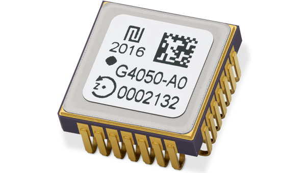
Tronics Microsystems, a TDK company, has upgraded its GYPRO4000 product line, which consists of tactical-grade digital MEMS gyroscopes. As part of this product line, Tronics highlighted the GYPRO4300 and GYPRO4050 at INTERGEO 2024.
The GYPRO4300 is a high-dynamics MEMS gyro designed for precision navigation applications. It features a ±300 °/s input range, 200 Hz bandwidth and 1 ms latency, making it ideal for dynamic environments. With a bias instability of 0.4 °/h and an Angular Random Walk of 0.07 °/√h, the GYPRO4300 offers high-performance sensing in a compact, digital and low size, weight and power (SWaP) package.
Building on the GYPRO4300, the GYPRO4050 is a specialized North-seeking gyro for low-dynamics applications. This derivative offers 2° azimuth accuracy and is currently in the customer sampling stage. The GYPRO4050 maintains the same miniature package design as its predecessor, ensuring consistency across the product line.
At INTERGEO 2024, TDK showcased a prototype based on an ongoing research and development project. This new development utilizes the same miniature package as the GYPRO4300 and GYPRO4050 but demonstrates ultra-low noise capabilities, achieving an azimuth accuracy of less than 1°. This product is slated for launch in 2025.
The GYPRO4000 series offers a digital, cost-effective, low-SWaP alternative. The closed-loop architecture ensures strong vibration rejection, maintaining accuracy even in harsh conditions. The 24-bit digital SPI interface and miniature, hermetic ceramic package facilitate swift integration into various systems, including inertial navigation systems (INS) and inertial measurement units (IMU).
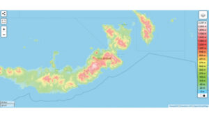
Elevation map of New Britain, Papua New Guinea. (Photo: topographic-map.com)
The Discovery Channel’s recently released “Finding Amelia” documentary explores the latest expedition aimed to uncover Amelia Earhart’s mysterious fate, featuring the participation of SPH Engineering. The film investigates the theory that Earhart and her navigator, Fred Noonan, may have crashed in Papua New Guinea during their 1937 attempt to circumnavigate the globe.
SPH Engineering joined the search nearly two years before the expedition, leveraging its experience from successful UAV operations in Greenland. The team’s mission focused on the dense jungles of New Britain, an island in Papua New Guinea, where they employed UAV technology to search for Earhart’s aircraft.
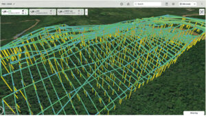
Planned routes for lidar scans in SPH Engineering’s UgCS flight planning software. (Photo: SPH Engineering)
Technology and challenges
The documentary follows the testing for the mission, which began in February 2021. The team conducted experimental detection of aircraft engines using UAV-mounted magnetometers. These experiments led the team to request satellite imagery and elevation maps of where the expedition was planned. This map was essential for studying the terrain and preparing for the mission. According to the analysis, the average expected vegetation height of 10 to 15 m allowed for the detection of aircraft engines using a magnetometer.
The SPH Engineering team arrived on-site with a suite of UAVs equipped with magnetometer, lidar and photogrammetry tools.
During the search, a small UAV equipped with a camera was first used to create precise maps of the search area. These maps were essential for planning subsequent flights. The team then conducted lidar scanning from a safe altitude to build digital surface models (DSM) and digital terrain models (DTM) to plan magnetic surveys.
The next step was to conduct the survey using a UAV-based magnetometer. The team found that while the average height of trees allowed for the detection of aircraft engines using a magnetometer, the presence of extremely tall trees made magnetic flight planning difficult.
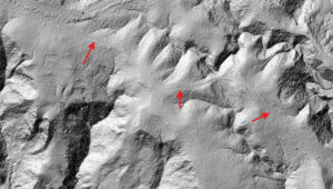
Processed lidar data showing potential Japanese troop trails. (Photo: SPH Engineering)
Janis Kuze, director of special projects for SPH Engineering explains the challenge. “In contrast to what we saw in satellite data available before the expedition, the average height of the trees was a bit greater, but the main problem was real ‘skyscrapers’ towering up to 60 m. These extremely high trees were totally missed in satellite elevation data. Despite the challenges, we had relative success detecting magnetic anomalies over the B-17 bomber crash site.”
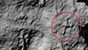
Processed lidar data showing the object resembling the shape and size of Amelia Earhart’s aircraft. (Photo: SPH Engineering)
Operation and results
Due to the high trees and the limited amount of magnetic ferrous metal in airplane engines, reliable detection using magnetometers proved difficult. The team then decided to switch back to lidar. Dozens of low-altitude lidar flights were conducted, using previous scans for flight planning, to build a detailed map of the ground surface beneath the trees.
The results revealed what is believed to be hidden Japanese troop trails and something resembling the shape and size of Amelia Earhart’s aircraft, the Lockheed Electra.
At INTERGEO 2024, ComNav Technology previewed its Jupiter Laser RTK, designed for surveying applications. The Jupiter Laser RTK integrates GNSS, auto-IMU (inertial measurement unit), laser and dual-camera systems into a single unit. The system is set to be released in 2025.
The system builds upon the laser technology featured in ComNav’s Universe series, incorporating a precise green laser that remains visible even in bright daylight conditions. This feature enables precise measurements of points in hard-to-reach, signal-blocked or potentially hazardous locations,, thereby pushing the boundaries of surveying accuracy and efficiency.
The RTK system’s laser range is up to 50 m, substantially extending the measurement capabilities while maintaining high accuracy, making it suitable for challenging surveying environments.
The Jupiter RTK system incorporates visual technology to offer surveyors an immersive experience during surveying and stakeout operations, improving working efficiency and productivity. Furthermore, Jupiter’s night vision camera allows users to clearly see feature points even in low-light conditions compared with competitive products. In very dark conditions, the feature points are unfeasible to recognize via camera, then the laser further makes up for this shortcoming. With Survey Master software’s intuitive guidance, even novice operators can stake out points seamlessly without the need for repositioning—provided the stakeout point is accurately marked on the ground.
During an on-site demonstration at INTERGEO 2024, participants experienced firsthand the convenience offered by Jupiter integrating laser and visual technologies. ComNav’s integration of laser technology into traditional GNSS receivers has been fully applied and validated in their Universe Series Laser RTK. This series includes:
Mars Pro Laser RTK: This device features a sunlight-readable OLED color display for easy operation. It tracks 1668 channels for all running and existing constellations and is compatible with mainstream brands of GNSS receivers.
Mars Laser RTK: With 1590 channels full-constellation multi-frequency tracking capability, Mars ensures precision and minimizes user fatigue, crafting an impressive surveying experience. The built-in transceiver datalink module has a super long working distance of up to 15 km.
Venus Laser RTK: This model offers a lightweight handheld design and rodless operation capability, simplifying surveying and stakeout processes while providing exceptional stability and accuracy. It is engineered to enhance user safety in challenging environments.
Advanced Navigation has finalized a $6 million deal with Hanwha Defence Australia (HDA). Under the agreement, Advanced Navigation will supply HDA with 138 Boreas D70 units, a strategic-grade digital fiber-optic gyroscope (DFOG) inertial navigation system (INS), as part of the LAND 400 Phase 3 program.
This dual-use technology is optimized for contested environments where GNSS accuracy and availability can be compromised.
The LAND 400 Phase 3 program aims to enhance the capabilities of the Australian Defence Force’s (ADF) armored vehicles. HDA is contracted to deliver 129 Redback infantry fighting vehicles (IFV) to ensure the Australian Army can respond to land challenges while providing high-level protection and mobility for soldiers. The total value of the project is approximately $7 billion.
According to HDA, the Redback vehicles are advanced fifth-generation infantry fighting vehicles (IFVs) developed for Australian requirements while utilizing the latest technology. The company said that the integration of Advanced Navigation’s INS allows these vehicles to achieve unprecedented levels of autonomy and resilience without the aid of GNSS.
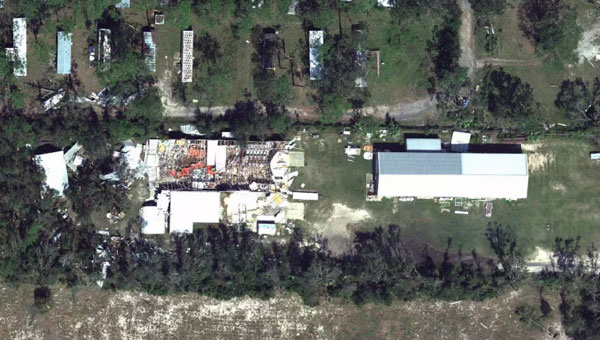
Hurricane Helene has caused widespread devastation across the southeastern United States, leaving a trail of destruction more than 500 miles long from Florida to the Carolinas. The storm made landfall at the Big Bend of Florida, on Sept. 26, 2024, as a Category 4 hurricane with sustained winds of 140 mph.
The death toll has risen to at least 215 across six states, with hundreds more still unaccounted for, reported ABC News. More than 4.5 million people initially lost power due to the hurricane, with more than two million residents still without electricity days after the storm. Utility companies face significant challenges in restoring power due to blocked and damaged roads. The storm’s destruction has rendered many essential roads and bridges impassable, complicating recovery efforts.
Role of GNSS in Recovery
GNSS plays a crucial role in disaster recovery operations. These systems provide essential positioning, navigation and timing (PNT) services critical for search and rescue efforts such as flood monitoring. GNSS technology enhances emergency services by enabling synchronized communication networks, providing precise location information and allowing for faster response times. With cell towers and electrical services down, GNSS empowers virtually all disaster recovery efforts.
Over the years, our reliance on GNSS has increased into an aspect of life we often overlook. Its importance is emphasized in times of disaster, PNT is critical.
A recent public safety announcement issued by the Space Force highlights that a critical component of any successful rescue operation is time. Knowing the precise location of landmarks, streets, buildings, emergency service resources and disaster relief sites reduces the time it takes to navigate challenging terrains to save lives. This information is critical to disaster relief teams and public safety personnel in order to protect life and reduce property loss. GPS serves as the fundamental technology in addressing these needs.
The United States Geological Survey (USGS) is also collecting flood data and repairing damaged streamgages to monitor water levels after Hurricane Helene.
USGS Mapping the Aftermath
As of Oct. 7, USGS provisional streamgage data indicates that at least 34 new flood records were set across the southeast from flooding caused by Helene. Eighteen of these provisional records were set in North Carolina, with six in Tennessee, six in South Carolina, three in Florida and one in Georgia.
In Newport, Tennessee, USGS field crews were able to measure high-water marks left behind by flood waters and determined the Pigeon River reached a provisional peak water level of 29.72 ft. The previous record on this river was 21.40 ft, set in 1902.
As communities begin the long process of rebuilding, they face numerous challenges, including limited resources, prolonged power outages and disrupted communication systems. However, GPS serves as a backbone in the recovery process, highlighting its significance in times of disaster. The full extent of Hurricane Helene’s impact is still being assessed, with authorities warning the death toll may continue to rise as search and rescue efforts progress.
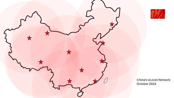
The Dunhuang long-wave timing station, a critical component of China’s high-precision ground-based timing system, has been completed and tested. This marks a significant advancement in China’s development of a three-dimensional cross-timing system that spans air, space and land.
Zhang Shougang, director of the National Time Service Center of the Chinese Academy of Sciences, told Xinhua News that the high-precision ground-based timing system leverages eLoran radio long-wave and fiber-optic timing technology. This system is designed to operate independently of satellite navigation timing, providing backup, complementary functions and mutual enhancement with existing timing systems.
China has constructed three additional long-wave timing stations in Dunhuang, Korla and Nagqu. When combined with existing stations, the new stations are designed to achieve nationwide coverage of long-wave timing signals.
During the construction of the Dunhuang station, researchers reported significant breakthroughs in high-precision transmission control and pulse time reference feedback modulation technology. They achieved a megawatt-level Loran timing transmission accuracy of 20 ns, surpassing the current international standard of 50 ns.
This advanced timing system seeks to support economic and social operations, foster technological development and improve national security. Zhang Shougang noted that after nearly 60 years of development, China has built the world’s most technically complete national timing system.
Advanced Navigation has expanded its Certus product line by introducing the Certus Mini series. This development marks a significant advancement in compact and high-performance navigation technology for field robots, autonomous vehicles and UAVs.
The Certus Mini series comes in three variants:
Certus Mini D: A dual-antenna inertial navigation system (INS)
Certus Mini N: A GNSS-aided INS
Certus Mini A: An attitude and heading reference system (AHRS)
These lightweight systems, weighing no more than 55 grams (1.9 oz.), offer impressive performance and cost-efficiency for their size.
The Certus Mini D utilizes dual-antenna GNSS for accurate heading, position, and velocity measurements. It operates on L1/L5 multi-constellation GNSS and offers enhanced interference immunity and position accuracy, particularly in challenging urban environments.
The Certus Mini series is designed to integrate into legacy systems and new builds. Its versatility makes it suitable for various applications, including surveying, agricultural robotics, open-pit mining and asset tracking.
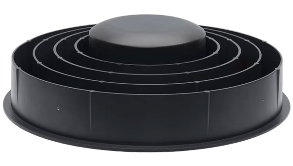
Calian GNSS, formerly Tallysman Wireless, has introduced the VCS6000XF full band smart choke antenna, a new product designed for Continuously Operating Reference Station (CORS) applications. This antenna combines Tallysman Verachoke antenna elements with Septentrio’s Mosaic X5 full-band receiver to offer an integrated solution for OEM CORS systems.
The VCS6000XF offers comprehensive GNSS signal reception, including GPS/QZSS L1/L2/L5, GLONASS G1/G2/G3, Galileo E1/E5a/E5b/E6/E5 AltBoc, BeiDou B1/B2/B2a/B3, NavIC L5, SBAS and L-Band correction services. It incorporates the advantages of the VC6050 Verachoke, such as low axial ratio, consistent frequency performance and excellent multi-path rejection.
The antenna features a 0.5mm phase center variation and utilizes Calian’s eXtended filtering for near-band signal interference mitigation. The integrated Septentrio Mosaic X5 receiver provides capabilities such as anti-jamming, anti-spoofing, scintillation mitigation and receiver integrity by combining the antenna and receiver in the choke ring antenna. This design eliminates the need for expensive low-loss RF cables and ensures a clean RF signal for the GNSS receiver.
By combining the antenna and receiver in the choke ring antenna, the VCS6000XF is engineered to address radio frequency (RF) signal degradation issues associated with long antenna cable runs. This design eliminates the need for expensive low-loss RF cables and can ensure a clean RF signal for the GNSS receiver.
Calian Smart Antennas can be customized to meet specific customer requirements, offering compatibility with various GNSS receivers and correction services. The company has achieved integrations with receivers from ST, u-blox and Septentrio and GNSS corrections from providers such as PointOne, Swift Navigation and PointPerfect.
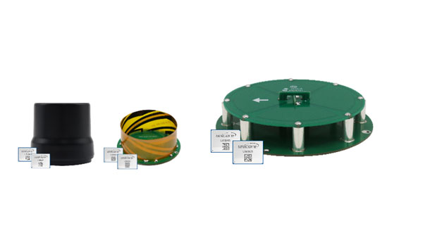
Harxon has introduced a new line of smart antennas that seamlessly integrate advanced antenna technology with a comprehensive real-time kinematic (RTK) positioning module. These products offer high-precision positioning capabilities within a compact and easily integrable form factor, making them ideal for various applications.
The smart antennas incorporate full-constellation, full-frequency RTK positioning modules, enabling a range of accuracy levels to suit different needs. Users can achieve single-point meter-level accuracy, DGPS sub-meter-level accuracy or RTK centimeter/millimeter-level accuracy depending on their requirements.
The series includes both housed and embedded versions tailored for specific use cases. The HX-MR401A and HX-MR402A are housed versions, while the HX-ME403A and HX-ME404A are embedded versions designed for UAVs. These models leverage Harxon’s low-profile helix antenna technology. For robotic lawnmowers, Harxon offers the HX-ME401A and HX-ME402A, which are based on the cost-effective and high-performance OEM GNSS Antenna HX-CSX231A26.
Photo: Harxon
OEM GNSS antenna
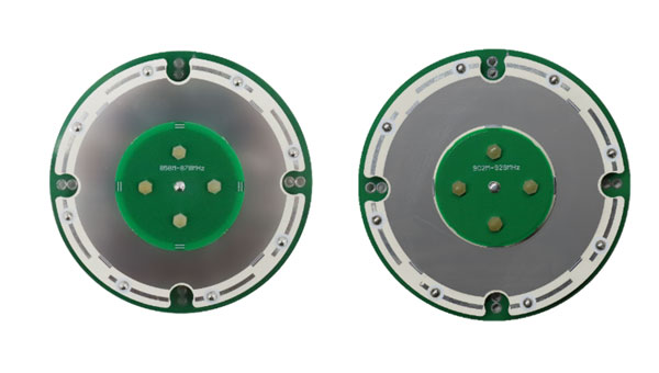
Harxon has expanded its OEM GNSS antenna lineup with two combined antennas: the HX-SE402A and HX-SE403A. These full-band, full-frequency antennas integrate GNSS capabilities with a low-profile radio antenna that supports the 858-878MHz and 902-928MHz frequency bands. This addresses the growing need for devices requiring both navigation and communication functionalities.
Unlike traditional whip-shaped radio antennas, which can extend up to 20 cm, Harxon’s new low-profile technology achieves the same functionality at 10 mm height, which allows for greater versatility in applications that demand precise positioning alongside wireless communication. Additionally, Harxon offers custom tuning services to optimize integration into OEM end-user modules for specific applications.
Photo: Harxon
Anti-jamming GNSS antenna
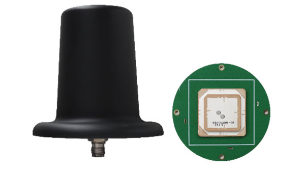
Harxon has introduced its inaugural series of anti-jamming antennas, starting with two initial models: PT023 and PT024. These GNSS antennas are specifically engineered to operate in challenging environments characterized by complex electromagnetic interference, high-power signals and strong multipath effects.
They are well-suited for scenarios involving low-elevation angle interference, high-power interference sources and radio communication system noise. The PT023 model utilizes multiple array elements combined with amplitude and phase manipulation to achieve spatial radiation shaping. This antenna also incorporates advanced multi-level filtering technology, effectively suppressing out-of-band noise power.
In contrast, the PT024 model features vertical and horizontal two-dimensional polarization suppressors. This design effectively mitigates the reception of both odd and even LHCP and RHCP signals originating from the rear of the antenna, according to the company. It can also suppress low-elevation multipath signals at the same frequency and out-of-band noise signals. These features collectively enhance the antenna’s performance in complex electromagnetic environments.