Instead, the ANPR-FASTag hybrid system will continue to rely on ground-based high-speed cameras to identify vehicles and radio-frequency-identification FASTag readers to charge them.
The Ministry of Road Transport and Highways is proceeding with corridor projects relying on automatic number-plate recognition (ANPR) and FASTag systems, which don’t require vehicles to stop. A GNSS toll system tracks the exact location of the vehicle and calculates the distance traveled on a toll roll, ensuring that users end up paying for just the distance they actually traveled.
For several years, the Indian government had intended to implement a GNSS-based toll system based on real-time location tracking. Now, it looks like these plans have been scrapped.
Promoting precious pollinators
Washington State University (WSU) is leading the Pacific Northwest Pollen Atlas (bees.wsu.edu) to map and describe pollen. It aims to determine pollinator health and thus food humans eat that depend on pollination. Honey bees and other pollinators collect pollen from plants within a two-mile radius of their hive.
“We hope to create a database of plants and share the nutrient content in their pollen so gardeners can plant a healthy variety,” said Priya Chakrabarti Basu, WSU assistant professor, Entomology.
Researchers will map pollen varieties collected by citizen scientists in every Washington county over a four-year period and colleagues around the Pacific Northwest are also recruiting to increase the project’s scope. Expected to take decades to complete, the efforts are part of Basu’s larger effort to map pollen nutrition across North America.
How’s the weather out there?
High-resolution atmospheric data is the missing link in forecasting weather. A new approach sharpens GNSS tomography, while showing how the model makes decisions — a transparency critical for building trust as AI enters weather forecasting.
By revealing the hidden details of storms and humidity patterns, the new method can give forecasters the tools needed to anticipate extreme events with greater confidence, according to researchers at Wrocław University, Poland. The team described their deep-learning framework in a paper published in Satellite Navigation in August.
With sharper GNSS tomography, meteorologists can feed more accurate humidity fields into both physics-based and AI-driven forecasting models, significantly improving storm prediction and early-warning systems.
Africa is really huge
Photo: Equal Earth, Strebe / CC BY-SA 4.0
A Correct the Map campaign aims to replace the 16th-century Mercator map because it doesn’t show the true size of Africa, which is three times as large as Europe. Supporters say the historic map — created to guide European explorers — promotes a false view of the continent and its size, fostering a false impression that Africa is “marginal.”
In August, the 55-country African Union endorsed the campaign to have organizations around the world replace the Mercator with alternatives such as the 2018 Equal Earth projection. The African Union is expected to make an official decision to adopt the Equal Earth map in February. The campaign also asks the United Nations and the BBC to adopt the Equal Earth map.
VIAVI Solutions has received an award from the U.S. Department of Transportation (DOT) through its Complementary Positioning, Navigation and Timing (CPNT) Action Plan Rapid Phase II.
VIAVI will integrate and test its SecureTime altGNSS GEO-L service and SecurePNT 6200 resilient timing solution at the VIAVI Automated Lab-as-a-Service for Open RAN (VALOR) and the Open RAN Center for Integration and Deployment labs. VALOR and ORCID are funded by the National Telecommunications and Information Administration Public Wireless Supply Chain Innovation Fund.
Incidents of GNSS signal interference, such as jamming and spoofing, have increased significantly in recent years, emphasizing the need for a resilient PNT ecosystem that can function in denied, degraded and disrupted space operational environments (D3SOE). Complementary to GPS and GNSS, VIAVI’s SecureTime GEO-L service and SecurePNT-6260 switch to a completely GPS-independent, GEO-L satellite-based time service and a precision holdover clock in the event of jamming or spoofing with no interruption perceived by the critical infrastructure system.
The DOT action plan aims to test systems that augment or replace GPS and GNSS, providing accurate timing services to critical infrastructure ranging from data centers and financial systems to power grids and cellular networks. Data from the VALOR, ORCID and field trials will be used to support widespread adoption of complementary positioning, navigation and timing services to protect the nation’s critical infrastructure.
“Integration and testing at the VALOR and ORCID labs demonstrate the technology’s readiness in an operational critical infrastructure environment. We look forward to partnering with DOT and NTIA to improve resilience for critical infrastructure and providing vital data to support widespread CPNT adoption,” said Doug Russell, senior vice president and general manager of aerospace and defense at VIAVI.
In addition to integration and testing at the VALOR and ORCID labs, the VIAVI GEO-L service and user equipment will be tested at an upcoming government field test event that provides live-sky jamming and spoofing of GPS/GNSS.
Allows upgrades of older machinery for smaller farms
Topcon’s has created a Value Line Steering solution for farmers using mid-range tractors on small- to medium-sized farms. It makes autosteering technology — typically used on larger machinery — accessible to a broader range of farmers. Farmers with older or smaller machinery, or small specialty farms, can boost the value of their machinery with the autosteering technology. The integrated system is designed to work across a wide range of applications, machinery and brands. It includes compliance with ISOBUS-UT to offer universal compatibility and ease of use. The package includes a GNSS receiver, electric steering wheel controller, touchscreen console and Horizon Lite software, compatible with front-wheel-steer tractors. Farmers can add local, satellite or RTK correction services such as Topcon’s Topnet Live for enhanced precision.
infiniDome has introduced Aura, a new GNSS protection system built for platforms that cannot afford to lose their way. According to the company, this development comes at a time when GNSS interference incidents have surged by more than 400% across Europe and the Middle East over the past two years, making uninterrupted navigation a strategic necessity.
Developed from years of field-proven operational experience, Aura is designed to redefine navigation resilience with smarter algorithms, faster interference response and a compact, rugged design capable of operating in contested environments.
The system is available in two configurations: Aura, the enclosed version for rapid deployment, and AuraCore, the OEM module for integration. The system brings mission-grade protection to platforms ranging from small UAVs to large autonomous vehicles.
Among several new capabilities, Aura features enhanced null-depth performance, enabling the system to withstand higher jamming power, and a new saving power mode that dynamically reduces energy consumption when no interference is present.
“Aura isn’t just an upgrade; it’s a new philosophy,” said Omer Sharar, CEO of infiniDome. “It takes everything we’ve learned from real-world interference events and transforms it into a smarter, faster and more adaptive layer of defense. With Aura, we’re not just protecting GPS; we’re protecting autonomy itself.”
Engineered for modern battlefields and complex environments, Aura introduces a new level of performance and resilience.
Its adaptive algorithms ensure reliable navigation under evolving jamming conditions, while the optimized C-SWaP design keeps the system lightweight, low-power and mission-ready.
Capable of mitigating interference from up to three directions per frequency simultaneously, Aura delivers protection that is powerful and efficient, tested and validated in live high-power jamming environments across multiple regions.
These results position Aura as one of the most advanced and field-proven GNSS protection systems available.
With Aura, infiniDome said it continues to advance its vision of navigation resiliency, ensuring that operators stay connected, coordinated and in control, even under severe electronic attack.
Aura is available for early access evaluation and OEM integration, with full release scheduled for early 2026.
The program, managed under DIU’s Emerging Technologies portfolio, accelerates adoption of commercial quantum sensing technologies to ensure positioning, navigation and timing resilience in environments where Global Navigation Satellite Systems signals are unreliable or denied. SandboxAQ will deploy its dual-use AQNav software to enable robust navigation capabilities without reliance on external signals, demonstrating the technology’s utility in real-world scenarios and generating a comprehensive dataset to benchmark results against relevant Defense Department use cases.
“AQNav represents a vital, non-GPS-reliant path for PNT and has proven its readiness for expanded military demonstrations and evaluation across mission-critical platforms,” said Luca Ferrara, general manager of AQNav at SandboxAQ. “We’re demonstrating AQNav’s performance capabilities across DIU-relevant use cases to empower the DOD to solve complex PNT challenges with best-in-class technologies at its disposal.”
About the Transition of Quantum Sensing Program
The program is a strategic effort to accelerate adoption of advanced quantum sensors from the laboratory into real-world military applications. Its primary goal is to address critical joint force needs, particularly for resilient positioning, navigation and timing in GPS-denied environments and for next-generation anomaly detection.
More on Magnetic Navigation
DIU is addressing the DOD’s urgent need for jam-resistant navigation for aerial platforms operating in challenging environments. The effort focuses on prototyping magnetic navigation systems, which use advanced quantum magnetic sensors to navigate using Earth’s natural geomagnetic variations. The technique provides a resilient source of position data even in GPS-denied scenarios, such as over-ocean operations, reduced visibility and electronic jamming.
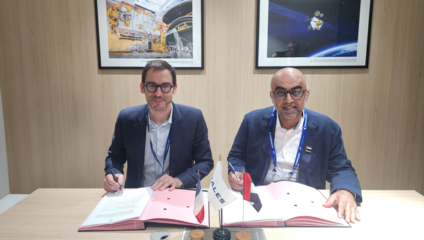
The National Space Science and Technology Center (NSSTC) and Thales Alenia Space, a joint venture between Thales (67%) and Leonardo (33%), are cooperating to explore opportunities in low-Earth orbit (LEO) space navigation systems.
The growing dependence of economies and daily lives on Global Navigation Satellite Systems is driving innovation and leading to technologies that deliver enhanced resilience and improved performance. At the forefront, low-Earth orbit positioning, navigation and timing (PNT) is emerging as a game-changer.
The LEO-PNT satellites seek to provide guaranteed and sovereign centimeter location accuracy, robustness, resistance against jamming and spoofing, and low latency. LEO-PNT will serve emerging applications such as high-level autonomy cars, including persistent coverage in dense urban areas, unmanned aerial and maritime vehicles, and 5G/6G ground telecommunication network synchronization.
Recognizing the strategic importance of LEO-PNT, the NSSTC is working with Thales Alenia Space to explore opportunities in this domain. The partnership was formalized through the signing of a memorandum of understanding at the Paris Air Show 2025, establishing a framework for cooperation. Building on that foundation, both parties signed an agreement marking the start of joint technical studies and engineering activities focused on regulatory protection and system design elements for LEO-PNT.
The collaboration reflects a vision to explore pathways that can enhance the robustness and sovereignty of future navigation services while deepening international cooperation and knowledge exchange between the United Arab Emirates and Europe in the field of space technology.
“This collaboration marks an important step toward building the UAE’s next-generation navigation capabilities,” said Ali Al Shehhi, director of NSSTC. “LEO-PNT will bring a new level of precision and resilience, and working with Thales Alenia Space allows us to accelerate our path toward a sovereign system that supports the UAE’s long-term strategic vision.”
“LEO-PNT is a game changer in satellite navigation in terms of increased precision, resilience and signal penetration, enabling new applications and economic growth,” said Hervé Derrey, CEO of Thales Alenia Space. “We are proud to offer our expertise in satellite navigation to the NSSTC, thereby strengthening our collaboration with the United Arab Emirates in the space domain.”
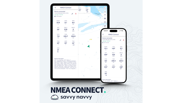
Marine navigation company Savvy Navvy introduces a new NMEA Connect feature that seamlessly integrates NMEA-enabled boat instruments with the app, providing real-time data and enhanced AIS visibility.
Working with award-winning Actisense, recognized globally for their NMEA interconnectivity specialty, Savvy Navvy’s new NMEA Connect feature enables boaters to view real-time data including wind, depth, engine RPMs, speed through water, heading and more in the app.
By combining onboard and over-the-horizon AIS, NMEA Connect delivers a complete view of nearby vessels for safer, smarter navigation. Through NMEA Connect, boaters can now access their boat’s instruments and Savvy Navvy’s smart routing technology from their pocket, eliminating the need to switch between multiple screens or devices.
“Boaters increasingly seek apps that simplify navigation and enhance onboard intelligence. NMEA Connect combines the proven reliability of NMEA technology with Savvy Navvy’s smart routing capabilities, giving boaters everything they need in one place. For boats without NMEA-compatible chart plotters, Savvy Navvy now becomes your all-in-one display,” says Misha Vysokovskiy, chief product officer at Savvy Navvy.
Actisense, global specialists in marine electronics, help leisure and commercial operators build safer, smarter and more dependable onboard networks.
“Savvy Navvy already delivers a huge amount of value to boaters, pulling together geographic location and environmental data streams. The addition of NMEA data connection means that other integral navigation and systems data will give boaters better visibility of things like depth, speed over ground, wind speed, heading and engine RPM — all within the easy-to-use Savvy Navvy app. Actisense are proud to have partnered with Savvy Navvy, lending our NMEA specialism. We share company missions of making journeys safer and more efficient through better data,” says Justin Cohen, commercial director at Actisense.
Savvy Navvy has had more than 3 million downloads globally. Unlike any other boating navigation solution, Savvy Navvy provides smart routing — giving users optimal routes and dynamic ETAs based on real-time data: departure time, chart information, weather conditions, tide, boat specifications and local regulations.
The NMEA Connect feature comes just weeks after Savvy Navvy launched an industry-first new chart annotation tool and Three Point Fix, following requests from boating instructors to turn digital charts into interactive learning tools for the next generation of boaters.
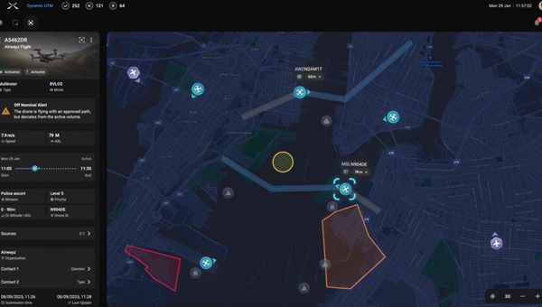
Airwayz, an AI-based unmanned traffic management company, has released a new version of its Dynamic UTM service and was awarded a research contract under the third round of the Israel National Drone Initiative (INDI3) research programs.
The new version introduces significant advancements in automation, intelligence and efficiency, providing clearer situational awareness, mitigating air risks and reducing the cognitive workload for airspace managers and drone operators, the company said.
“With the new version of the Dynamic UTM, we’ve refined intelligence, usability and automation to deliver real operational value — from planning and approval to execution and debriefing — while paving the way toward autonomous airspace management of the future,” said Yair Yosef, co-founder and chief product officer of Airwayz.
The updated system enhances workflow efficiency, communication across airspace layers and data-driven decision-making, enabling authorities to manage more missions simultaneously, safely and with greater precision, the company said.
It now provides periodic analytics and insights for authorities such as ports, airports and airspace regulators — offering visibility into trends like traffic density, mission types and operational loads. These insights support resource planning, safety strategies and potential future monetization models. Data is compiled periodically, such as monthly or at customized intervals, turning operational data into actionable intelligence.
The updated interface and AI-driven logic provide a more intuitive experience that enhances situational awareness and decision confidence, enabling users to focus on outcomes rather than system complexity, Airwayz said.
The company also upgraded its Airwayz Airplan platform, the mission management tool for drone operators.
New features include an improved drone database that speeds up flight request submissions, improves UTM communication and delivers more accurate mission statistics; duplicate flight requests that replicate recurring missions in seconds, saving more than 75% of submission time; and updates to existing flights that allow real-time changes to active or scheduled missions without cancellation.
The company’s next evolution will focus on “democratizing tactical airspace command and control,” extending from strategic oversight to mission-level defense and security.
The company also was awarded a grant to research UTM technologies and procedures as part of the INDI project, a joint venture led by the Israel Innovation Authority and partnering agencies.
Spirent Communications, now part of Keysight Technologies, announced PNT Xe, a GNSS simulation platform designed to expand high-performance GNSS testing across the development lifecycle. The platform aims to reduce barriers to positioning, navigation and timing testing by offering simulation capabilities in what the company describes as an economical, multipurpose platform.
The company said PNT Xe addresses challenges manufacturers face in validating GNSS performance during accelerated development schedules. The platform’s hardware supports testing from early prototypes through production line verification for commercial and military applications.
“Until now, many organizations have been forced to use unreliable, inconsistent simulators or utilize ‘live sky’ signals as a way of conducting production testing,” said Peter Terry-Brown, divisional CEO of Spirent’s positioning business. He said PNT Xe makes the company’s simulation technology available for workstations, engineers and project phases.
Terry-Brown said the platform allows developers, integrators, design verification teams and production line testers to use consistent test methodology without compromising results validity. Many leading GNSS chipsets and modules are developed using Spirent’s simulators, he said.
The compact PNT Xe can be rack or desk mounted and features an interface designed to accelerate scenario creation. The platform can operate in lab or field environments and withstand variations in temperature and vibration while maintaining performance, according to the company. It supports all GNSS constellations and frequencies and includes AES M-Code access and a removable system disk for secure testing environments.
Rob VanBrunt, CEO of Spirent Federal Systems, called PNT Xe “a game-changer for defense customers.” He said the platform’s ease of use will help deploy new PNT technology faster, allowing software engineers to test code changes at their desks. Authorized GPS M-Code users can conduct unclassified military signal testing using AES M-Code without relying solely on secure labs, he said.
Marie Hattar, chief marketing officer at Keysight Technologies, said accurate, high-performance simulation becomes critical as positioning and timing technologies become foundational to 6G, defense systems and autonomous vehicles. PNT Xe makes that capability available to more innovators to validate performance, reliability and resilience at every development stage, she said.
Built on Spirent’s 40 years of expertise, PNT Xe is designed for development and production environments including low-altitude drones, vehicles, space applications, automotive, defense, and consumer devices.
America’s dependence on GPS is a matter of national security, economic vitality, and daily life. We all agree: the United States must develop strong, resilient alternatives to satellite-based positioning, navigation and timing (PNT). The question, ironically enough, is how to get where we want to go.
Z-Wave Alliance, whose members build the smart home, security, and automation devices used in millions of homes and buildings, fully supports the federal effort to harden PNT infrastructure. We have been active contributors to the FCC’s Notice of Inquiry (WT 25-110) and the Department of Transportation’s Complementary PNT (CPNT) research program. We have provided and assessed technical data to help identify which terrestrial and space-based solutions can truly coexist with the technologies Americans already use every day.
A Known Risk
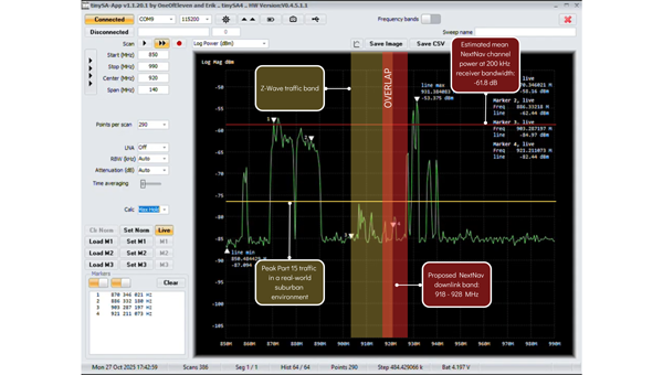
NextNav has petitioned the FCC to restructure parts of the lower 900 MHzband to host a terrestrial 5G/PNT network—essentially a ground-based GPS complement. The company’s plan would allocate parts of that band for high-power transmissions and relax the long-standing protections that keep low-power (Part 15) devices from destructive interference.
That same spectrum underpins hundreds of millions of existing systems: connected security sensors, toll-booth readers, smart meters, building automation networks, and the smart home products consumers rely on every day. These devices operate safely and efficiently because the FCC’s Part 15 rules limit interference and prohibit high-power operations in this shared public band.
Robust technical analysis, most recently the Pericle Communications study commissioned by the Security Industry Association, shows that high-power terrestrial PNT transmissions would block or degrade low-power communications up to 60 percent of the time. In plain terms, that means alarms that fail to trigger, silent sensors, and lost connectivity for devices that safeguard homes, businesses, and infrastructure.
Evidence indicates these devices could degrade significantly in performance, often to the point of un-usability. Once the band is reclassified, there’s no practical way to “retrofit” the millions of products already deployed. The result would be billions of dollars in stranded hardware, irrecoverable damage to company reputations, and a long, expensive replacement cycle for utilities, business owners, and consumers.
This isn’t an argument against terrestrial PNT. It’s an argument for evidence-based engineering.
— Avi Rosenthal
Multiple Paths to Resilient PNT
This isn’t an argument against terrestrial PNT. It’s an argument for evidence-based engineering. The Department of Transportation has identified several categories of GPS-complement technologies, including low-Earth orbit (LEO) satellite systems, time-over-fiber distribution, map matching/map tracking, and terrestrial RF. NextNav’s 900 MHz concept falls into the fourth category, but it’s only one of many.
The FCC recognized this when it opened its broad Notice of Inquiry in March 2025 instead of rushing into rulemaking. Other federally funded trials, such as the Broadcast Positioning System developed by NAB and UrsaNav’s eLoran solution, show that terrestrial PNT can be achieved without displacing unlicensed Part 15 devices.
Engineering redundancy into national infrastructure demands that we test multiple solutions in parallel, not gamble on a single proprietary approach that risks breaking what already works.
Coexistence Is the Standard, Not the Exception
Across every modern wireless domain — Wi-Fi, Bluetooth, Zigbee, Z-Wave, LoRa, Wi-SUN — coexistence testing is standard practice. Before a new technology enters a shared spectrum, it must demonstrate that it can live alongside incumbents. NextNav has not done that. Its coexistence claims rely primarily on simulations using optimistic assumptions about device density and duty cycle. Real-world deployments are far denser and far noisier.
Z-Wave and our industry partners simply ask for what every responsible engineer would: comprehensive, transparent field testing before the FCC alters the rules of a crowded band. That’s not obstructionism: it’s diligence.
Building Forward, Not Backward
Our message is simple: the U.S. needs PNT redundancy, but it must be built on coexistence, not displacement.
America’s connected infrastructure relies on the lower 900 MHz band precisely because it has been open, unlicensed, and reliable. Allowing a single licensee to flood that band with high-power signals would trade resilience for fragility.
Z-Wave Alliance stands ready to collaborate with the FCC, DOT, and all research participants to ensure the U.S. gets the GPS backup it deserves: one that strengthens, rather than undermines, the technologies that keep Americans safe, secure, and connected every day. To learn more, follow Z-Wave Alliance on LinkedIn and across social platforms: we are committed to keeping the U.S. technology community up-to-date on key proposal developments and opportunities to make their voices heard.
America’s dependence on GPS is a matter of national security, economic vitality, and daily life. We all agree: the United States must develop strong, resilient alternatives to satellite-based positioning, navigation and timing (PNT). The question, ironically enough, is how to get where we want to go.
Z-Wave Alliance, whose members build the smart home, security, and automation devices used in millions of homes and buildings, fully supports the federal effort to harden PNT infrastructure. We have been active contributors to the FCC’s Notice of Inquiry (WT 25-110) and the Department of Transportation’s Complementary PNT (CPNT) research program. We have provided and assessed technical data to help identify which terrestrial and space-based solutions can truly coexist with the technologies Americans already use every day.
A Known Risk
NextNav has petitioned the FCC to restructure parts of the lower 900 MHzband to host a terrestrial 5G/PNT network—essentially a ground-based GPS complement. The company’s plan would allocate parts of that band for high-power transmissions and relax the long-standing protections that keep low-power (Part 15) devices from destructive interference.
That same spectrum underpins hundreds of millions of existing systems: connected security sensors, toll-booth readers, smart meters, building automation networks, and the smart home products consumers rely on every day. These devices operate safely and efficiently because the FCC’s Part 15 rules limit interference and prohibit high-power operations in this shared public band.
Robust technical analysis, most recently the Pericle Communications study commissioned by the Security Industry Association, shows that high-power terrestrial PNT transmissions would block or degrade low-power communications up to 60 percent of the time. In plain terms, that means alarms that fail to trigger, silent sensors, and lost connectivity for devices that safeguard homes, businesses, and infrastructure.
Evidence indicates these devices could degrade significantly in performance, often to the point of un-usability. Once the band is reclassified, there’s no practical way to “retrofit” the millions of products already deployed. The result would be billions of dollars in stranded hardware, irrecoverable damage to company reputations, and a long, expensive replacement cycle for utilities, business owners, and consumers.
This isn’t an argument against terrestrial PNT. It’s an argument for evidence-based engineering.
— Avi Rosenthal
Multiple Paths to Resilient PNT
This isn’t an argument against terrestrial PNT. It’s an argument for evidence-based engineering. The Department of Transportation has identified several categories of GPS-complement technologies, including low-Earth orbit (LEO) satellite systems, time-over-fiber distribution, map matching/map tracking, and terrestrial RF. NextNav’s 900 MHz concept falls into the fourth category, but it’s only one of many.
The FCC recognized this when it opened its broad Notice of Inquiry in March 2025 instead of rushing into rulemaking. Other federally funded trials, such as the Broadcast Positioning System developed by NAB and UrsaNav’s eLoran solution, show that terrestrial PNT can be achieved without displacing unlicensed Part 15 devices.
Engineering redundancy into national infrastructure demands that we test multiple solutions in parallel, not gamble on a single proprietary approach that risks breaking what already works.
Coexistence Is the Standard, Not the Exception
Across every modern wireless domain — Wi-Fi, Bluetooth, Zigbee, Z-Wave, LoRa, Wi-SUN — coexistence testing is standard practice. Before a new technology enters a shared spectrum, it must demonstrate that it can live alongside incumbents. NextNav has not done that. Its coexistence claims rely primarily on simulations using optimistic assumptions about device density and duty cycle. Real-world deployments are far denser and far noisier.
Z-Wave and our industry partners simply ask for what every responsible engineer would: comprehensive, transparent field testing before the FCC alters the rules of a crowded band. That’s not obstructionism: it’s diligence.
Building Forward, Not Backward
Our message is simple: the U.S. needs PNT redundancy, but it must be built on coexistence, not displacement.
America’s connected infrastructure relies on the lower 900 MHz band precisely because it has been open, unlicensed, and reliable. Allowing a single licensee to flood that band with high-power signals would trade resilience for fragility.
Z-Wave Alliance stands ready to collaborate with the FCC, DOT, and all research participants to ensure the U.S. gets the GPS backup it deserves: one that strengthens, rather than undermines, the technologies that keep Americans safe, secure, and connected every day. To learn more, follow Z-Wave Alliance on LinkedIn and across social platforms: we are committed to keeping the U.S. technology community up-to-date on key proposal developments and opportunities to make their voices heard.
As the geospatial industry accelerates toward automation and intelligence, ComNav Technologies is redefining its role in the market. In this exclusive interview, ComNav leadership discusses the company’s transition in 2025 — evolving from a traditional GNSS hardware provider into a comprehensive solutions and services company that seamlessly integrates positioning, perception and cloud-based intelligence.
As surveying evolves from manual, point-based measurement to automated, cloud-connected ecosystems, ComNav explains how they’re positioning themselves at the forefront of this industry transformation — empowering professionals to shift from repetitive fieldwork to high-value data processing and decision-making.
What would you consider ComNav’s most significant breakthrough in 2025?
Innovation — as our slogan says, “Innovation Makes a Difference.”
In 2025, ComNav has achieved a key transformation from being primarily a GNSS hardware provider to becoming a comprehensive GNSS solution and service company. We are extending our capabilities beyond traditional receivers and boards into CORS network construction, cloud-based GNSS services, and intelligent software platforms.
This transition marks a major step toward integrating hardware, software, and cloud services, allowing us to deliver not only precise positioning equipment but also complete, scalable solutions for global customers. It reflects our long-term commitment to driving innovation and shaping the future of intelligent navigation.
What key improvements has your technology recently achieved?
ComNav has made significant progress in multi-sensor fusion and core GNSS technology.
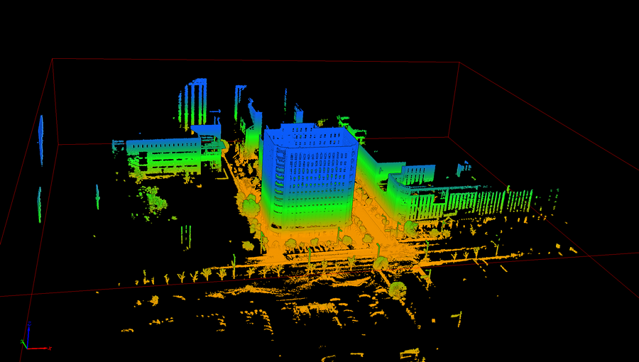
We have advanced our real-time multi-sensor fusion technology, integrating GNSS, lidar, camera and IMU to deliver higher reliability and spatial awareness in complex environments. This innovation enables a shift from point-based measurements to full 3D spatial mapping, opening new possibilities for surveying, autonomous systems, and digital twin applications.
ComNav’s real-time multi-sensor fusion technology, integrates GNSS, lidar, camera and IMU to deliver higher reliability and spatial awareness in complex environments.
How is ComNav planning to advance its multi-frequency, multi-constellation GNSS technology in 2025? Which constellations are you now supporting?
We proudly launched the fourth generation of our high-precision GNSS SoC chip, which integrates full-constellation, muti-frequency RF and BB into a single compact design. This chip offers higher positioning accuracy, lower power consumption, and improved anti-interference performance — setting a new benchmark for GNSS receiver technology.
It employs multi-constellation simultaneous equation technology, ground-based and satellite-based augmentation technologies, SBAS technology, RAIM technology to deliver highly reliable position and attitude information to users. The chip supports various positioning modes, including RTK, RTD, PPP, PDP, SPP, and GNSS + INS, making it suitable for a wide range of complex high-precision positioning scenarios.
Which industry sectors saw the most growth for ComNav solutions in 2025 – agriculture, construction, surveying, autonomous vehicles, or others? Are there any successful use cases you can share from these sectors?
ComNav’s Jupiter GNSS receiver integrates a 50 m laser, IMUm and camera technology.
In 2025, geospatial remained the fastest-growing for ComNav.
Driving this growth is our newly launched Jupiter GNSS receiver, which integrates a 50-meter laser, IMU, and camera technology. This combination enables non-contact measurement, greatly enhancing operational efficiency.
Our newly released LS600 laser scanner further expands this innovation. It combines advanced SLAM technology, a built-in RTK module for centimeter-level accuracy, and dual wide-angle cameras for vivid color capture. The LS600 significantly simplifies field workflows and allows users to easily obtain high-quality 3D point clouds, transforming traditional “single-point measurement” into multi-dimensional, intelligent data acquisition. This represents a major leap forward in efficiency, safety, and precision for complex surveying operations.
The LS600 seeks to significantly simplify field workflows. It allows users to easily obtain high-quality 3D point clouds, transforming traditional “single-point measurement” into multi-dimensional, intelligent data acquisition.
At the same time, our agricultural segment has also achieved remarkable growth. The AG501 Pro supports a wide range of guide line designs and delivers operational accuracy of up to 2.5 cm. Continuous software updates and optimization have further improved user experience, making precision agriculture simpler and more efficient. It embodies our commitment to empowering smarter, more sustainable agricultural operations through GNSS innovation.
Are there any new product lines we can expect to see launched next year?
In 2026, ComNav will introduce a new generation of integrated lidar and RTK products, combining high-precision GNSS positioning with advanced laser scanning technology. This integration will enable professionals to capture both geometric and spatial data simultaneously, delivering faster, more comprehensive field data collection.
We are also preparing to release an upgraded handheld laser RTK, designed for maximum portability and ease of use. With enhanced measurement accuracy, longer range, and improved connectivity, it will empower surveyors to perform rapid, precise measurements in a wide range of field environments.
These new product lines reflect ComNav’s ongoing commitment to expanding its technology ecosystem — integrating positioning, perception, and intelligence into one cohesive solution.
How do you see the industry evolving over the next year, and how is comNav positioning itself to stay ahead to market changes and challenges?
We believe the geospatial industry is entering a new stage of intelligence and automation. The traditional boundary between field data collection and office data processing is rapidly disappearing. Surveying is evolving from manual, point-based measurement toward automated, intelligent, and cloud-connected workflows — where data captured in the field is seamlessly processed, analyzed, and visualized in the cloud.
To stay ahead of this transformation, ComNav is focusing on intelligent integration — combining high-precision GNSS with sensors, AI algorithms, and cloud platforms. Our goal is to enable surveyors to shift their efforts from repetitive fieldwork to high-value, intelligent data processing and decision-making in the office.
By investing in smart software, real-time cloud services, and integrated hardware platforms, ComNav is positioning itself as a key driver in building the next generation of intelligent geospatial ecosystems.
The AG501 Pro supports a wide range of guide line designs and can deliver operational accuracy of up to 2.5 cm.