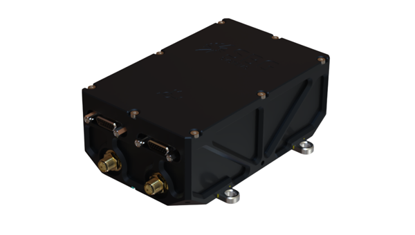
SBG Systems has expanded its product line with the launch of the Stellar-40, a modular and scalable inertial navigation system (INS) designed for demanding environments and mission-critical applications.
Designed for land, air and marine platforms, the Stellar-40 integrates a tactical-grade IMU, a GNSS receiver and advanced sensor fusion algorithms within a compact and rugged enclosure. The system is designed to provide reliable navigation performance in high-vibration, high-dynamics and electronically challenging environments.
The development of the Stellar-40 focused on two main objectives: increasing resilience in harsh operational conditions and improving production scalability. To overcome the vibration sensitivity commonly encountered in defense and industrial applications, SBG Systems implemented an innovative three-level mitigation approach:
Sensor-level isolation: Dampers integrated directly at the IMU sensor level reduce vibrations at the source.
Resonance-free enclosure: A specialized housing engineered to drastically minimize resonance and internally induced vibrations.
Structural isolation: Custom external dampers designed to isolate the unit from harsh vehicle dynamics.
This architecture supports stable system behavior in dynamic environments.
Beyond mechanical robustness, the Stellar-40 addresses modern electronic warfare challenges. The system incorporates a high-performance GNSS receiver designed to actively mitigate advanced jamming and spoofing threats. When GNSS signals are degraded or unavailable, the system relies on multi-sensor fusion and dead-reckoning capabilities to maintain navigation continuity.
Positioned as the heavy-duty counterpart to the Ekinox Micro, the Stellar-40 introduces a revised mechanical and electronic design intended to simplify integration and manufacturing processes. The system is suited for defense programs, robotics platforms, UAVs and autonomous systems requiring compact, scalable navigation solutions.
“Stellar-40 was developed with scalability and integration flexibility as key priorities,” said Kaoutar, product manager at SBG Systems. “The design aims to support a broad range of platforms while keeping large-scale production in mind. This product brings high-end resilience against vibrations, jamming and spoofing into a box that teams can completely trust in real-world operations.”
With the introduction of the Stellar-40, SBG Systems continues to expand its range of inertial navigation solutions for professional and industrial applications.
The Stellar-40 is designed for a wide range of applications across defense and autonomous systems. It supports platforms such as UAVs, robotics and other autonomous vehicles that require compact and scalable navigation solutions. Its revised mechanical and electronic design simplifies integration and manufacturing, making it well-suited for both large-scale production programs and demanding operational environments.
The world is rapidly filling with connected devices. IoT Analytics reports that 18.5 billion IoT devices were online in 2024, with growth accelerating toward an expected 21.1 billion by the end of 2025 and 39 billion by 2030. As artificial intelligence drives demand for richer, more precise device data, the need for reliable, high‑accuracy positioning becomes foundational.
Yet today’s GNSS infrastructure — including cellular-based real‑time kinematic (RTK) networks — was never designed for this scale. Billions of devices — from vehicles to drones to industrial sensors — depend on location data, but the traditional GPS model struggles under three converging pressures: (1) massive device growth, (2) rising accuracy requirements, and (3) increasing vulnerability to interference.
These pressures are reshaping expectations for positioning, navigation and timing (PNT) and creating demand for a new, more resilient delivery model.
Why Accuracy and Resilience Matter More Than Ever
Autonomous systems are the clearest example of the accuracy challenge. Xona Space Systems CTO Dr. Tyler Reid notes that safe autonomous driving requires 10 cm accuracy 95% of the time and 30 cm accuracy at “eleven nines” reliability. Standard GPS, accurate only to several meters, cannot meet these thresholds — even with traditional enhancement techniques.
At the same time, GNSS signals face growing threats. Spoofing and jamming events are now daily occurrences in parts of Europe, and U.S. federal agencies increasingly require contract bidders to incorporate resilient PNT technologies alongside legacy GNSS.
Finally, the explosion of IoT devices introduces a network‑scale challenge. Many of these devices could benefit from high‑precision positioning, but continuous unicast RTK streams are not an efficient use of cellular networks, especially as billions of devices come online.
Together, these factors point to a simple conclusion:
A new delivery model for high‑precision GNSS corrections is needed — one that is accurate, resilient, and scalable.
Why a Hybrid Approach Is Required
RTK positioning is the gold standard for centimeter‑level accuracy. It works by combining GNSS signals with correction data from a known base station. However, traditional RTK has two major limitations:
Coverage constraints — corrections must be delivered within a limited range of the base station due to the fact that accuracy diminishes the further the GNSS base is from the rover.
Network constraints — corrections are typically delivered over cellular networks, which become inefficient at scale.
Precise Point Positioning (PPP‑RTK) can extend range and reduce dependency on local base stations, but today’s PPP‑RTK implementations are proprietary and lack a common standard.
To support billions of devices — many mobile, many mission‑critical — the industry needs a correction‑delivery model that is:
Nationwide
Efficient at scale
Resilient to interference
Cost‑effective for high‑volume IoT deployments
This is where hybrid RTK becomes essential.
Introducing Hybrid RTK: A Dual‑Path Delivery Model
Hybrid RTK refers to the dual‑path delivery of GNSS correction data, consisting of:
Primary path: ATSC 3.0 broadcast
Fallback path: Cellular (LTE/5G)
Upstream messaging: Cellular for acknowledgments or device telemetry
Compared to a satellite-based RTK solution or even a cellular-only RTK solution, hybrid RTK will deliver corrections over a far more reliable and scalable network, because it’s both broadcast and terrestrial-based.
Why broadcast first?
ATSC 3.0 provides:
One‑to‑many multicast efficiency
Predictable capacity and uniform latency
Wide coverage footprints
Strong penetration in dense urban environments
Lower cost per delivered bit
This makes it ideal for distributing high‑precision correction data to large numbers of devices simultaneously — something cellular networks are not optimized for.
Why cellular second?
Cellular fills in:
Coverage gaps where ATSC 3.0 is not yet deployed
Uplink needs (e.g., device status, position feedback)
Mobility scenarios requiring two‑way communication
The result is a resilient, nationwide correction layer that scales with IoT growth.
EdgeBeam Wireless: A New Entrant with a Broadcast‑First Architecture
EdgeBeam Wireless is deploying a hybrid RTK network that leverages the existing infrastructure of U.S. television broadcasters — including secure facilities, hardened towers, and nationwide engineering resources — for both over-the-air RTK delivery and collocating GNSS base stations.
This approach provides several advantages:
Accelerated deployment of GNSS base stations designed to complement existing base networks.
Lower infrastructure costs than cellular‑only RTK networks.
High reliability through broadcast delivery.
Scalable distribution for dense IoT environments.
Nationwide reach as ATSC 3.0 coverage expands.
EdgeBeam’s broadcast‑first model — branded by the company as “Enhanced GPS” or “eGPS” — is best understood simply as hybrid RTK with broadcast as the primary downlink. While this hybrid approach does require some additional hardware to receive the broadcast, pricing is already very competitive to cellular because these chips will be found in every television set in the country. Moreover, EdgeBeam already has products available for end users that want to leverage a hybrid network without having to do any development work.
Broadcast RTK: A New Network Layer at the Edge
Broadcast RTK uses ATSC 3.0 to distribute GNSS correction data over the last mile. This creates a new edge network layer that can support both GNSS and other data applications, including:
High‑precision GNSS corrections
Multicast distribution of positioning data
Offloading of appropriate high‑volume traffic (e.g., video) from cellular networks
Enterprise‑grade reliability for industrial and transportation systems
By shifting the heavy downlink load to broadcast, cellular networks are freed to handle uplink messaging and mobility support — a more efficient division of labor.
This hybrid architecture is not just about improving individual device accuracy. It enables something more powerful.
A New Generation of Shared Situational Truth
When many devices operate on the same centimeter‑accurate reference frame at the same time, a new capability emerges: Shared Situational Truth (also known as shared situational awareness).
This refers to a consistent, real‑time understanding of location and timing across a fleet, system, or environment. Hybrid RTK enables this by delivering synchronized, high‑precision PNT to large numbers of devices simultaneously. By offloading RTK delivery to a broadcast network, cellular and other communication networks can then be used to share a device’s position and other data with other local devices.
What is being shared?
Precise location
Precise timing
Who is sharing it?
Vehicles
Fleets
Drones
Industrial robots
Infrastructure sensors
Emergency services
Insurance and logistics platforms
What does it enable?
Examples include:
Safer ADAS/ADS through lane‑level awareness
Collision avoidance for drones and autonomous systems
Fleet optimization using precise, time‑aligned movement history
Improved insurance models through reliable behavior measurement
Faster accident resolution with time-synchronized location records
Infrastructure‑to‑vehicle coordination for road hazards or construction zones
In transportation alone, EdgeBeam’s hybrid RTK solution could make entire traffic systems safer and more predictable — not just individual vehicles. And importantly, this can be done far more efficiently than via just a cellular-based solution.
Conclusion: A Foundational Shift in PNT Delivery
The convergence of IoT growth, accuracy demands, and GNSS vulnerabilities is forcing a rethinking of how high‑precision positioning is delivered. Hybrid RTK — with broadcast as the primary downlink and cellular as a complementary path — offers a scalable, resilient, and cost‑effective solution.
For industries ranging from automotive to logistics to public safety, the shift from “nice‑to‑have” to “must‑have” high‑precision PNT is already underway. As hybrid RTK networks expand, the ability to deliver centimeter‑level accuracy at scale will unlock new applications, new efficiencies, and new expectations for how devices understand and interact with the world.
EdgeBeam Wireless is building this new correction layer — one designed for the billions of devices that will depend on precise, reliable positioning in the years ahead.
Advanced Navigation has raised $110 million in a Series C funding round aimed at expanding its positioning, navigation and timing (PNT) technology portfolio.
Airtree Ventures led the round, with participation from Quadrant Private Equity and the National Reconstruction Fund Corporation (NRFC). Existing investors — including Main Sequence, KKR, In-Q-Tel, Alpha Intelligence Capital, Malcolm Turnbull and OIF Ventures — also participated.
The Sydney-based company develops alternative positioning, navigation and timing, or PNT, systems designed to function when GPS signals are degraded or unavailable. Its products are used across defense, energy, maritime and space applications.
Chris Shaw, CEO and co-founder of Advanced Navigation
Chris Shaw, chief executive and co-founder, said demand for GPS-independent navigation has grown as threats such as signal jamming, spoofing and infrastructure-denied environments have become more common.
“As autonomous vehicles scale into contested and high-stakes frontiers, the world’s reliance on any single navigation technology has evolved from a technical limitation into a systemic vulnerability,” Shaw said.
The company’s customers include Anduril, the National Oceanic and Atmospheric Administration, Hanwha, BHP, Rheinmetall and Intuitive Machines. Advanced Navigation reported triple-digit revenue growth over the past year, with more than 80% of revenue generated in the United States and Europe.
The company said it plans to use the funds to establish what it calls PNT Centers of Excellence in the U.S. and European markets, embedding engineering teams in key regions to support local operations and supply chains. The investment will also support technology acquisitions in robotics, photonics, computer vision, artificial intelligence and quantum sensing.
At the center of Advanced Navigation’s product architecture is a software fusion engine called AdNav Intelligence, which combines data from multiple sensors in real time to maintain navigation accuracy when GPS is unavailable.
The company has deployed more than 100,000 systems across multiple countries.
Ultra-low-noise amplifiers developed by European Engineering Consultancy Ltd. (EECL) are operating in orbit on the European Space Agency’s (ESA’s) HydroGNSS mission, marking a technical milestone for the hardware following the satellites’ launch in November 2025.
HydroGNSS consists of two small satellites designed to measure hydrological and climate-related variables using GNSS reflectometry. The satellites collect signals transmitted by navigation satellites such as GPS and Galileo and analyze those signals after they reflect from Earth’s surface. The reflected signals provide data on environmental parameters including soil moisture, freeze–thaw conditions in permafrost regions, wetlands and inundation, and above-ground biomass.
The satellites were launched aboard a SpaceX Falcon 9 rideshare mission from Vandenberg Space Force Base in California on Nov. 28, 2025. The mission is part of the European Space Agency’s Scout program, which focuses on relatively small and cost-effective Earth observation satellites designed to demonstrate new measurement techniques.
EECL designed and manufactured six multiband ultra-low-noise microwave amplifiers used in the spacecraft payload. The amplifiers are part of the radio-frequency front end of the receiver system and are designed to amplify very weak reflected GNSS signals while minimizing additional noise, helping preserve signal quality for scientific analysis.
Early on-orbit results indicate the satellites’ payloads are functioning as expected. Both spacecraft have begun collecting delay-Doppler maps of reflected GNSS signals, an early step in commissioning that confirms the receivers are acquiring and processing signals properly.
The HydroGNSS satellites were built by Surrey Satellite Technology Ltd., which also developed the GNSS receiver used on the mission. The spacecraft operate in low Earth orbit and are phased apart to increase global coverage of the measurements.
Data from HydroGNSS are expected to support research on the global water cycle and contribute to studies related to climate monitoring, agriculture, flood risk and ecosystem changes.
InfiniDome is set to debut its Aura GNSS protection system at XPONENTIAL Europe in Düsseldorf, Germany, March 24-26.
Aura supports two to four antennas and protects two GNSS frequency bands while passing two additional bands. The system can generate up to three nulls per protected band, allowing it to suppress multiple interference sources at once. The product is offered in two configurations: an enclosed version weighing 500 grams and an OEM version at 375 grams, the latter designed for integration into platforms where size and weight are constraints.
The company will also present IroNav, a navigation solution developed jointly with Wonder Robotics that combines InfiniDome’s anti-jamming technology with Wonder Robotics’ visual navigation and autonomy software. The layered architecture is intended to keep autonomous systems navigating when GNSS signals are degraded or unavailable entirely. IroNav is also making its European debut at the show.
InfiniDome recently entered the Indian market through a partnership with Globaz Technologies, which will serve as the company’s official partner in the country. The agreement is aimed at addressing demand for navigation resilience technology in India’s defense and unmanned systems sectors.
XPONENTIAL Europe is scheduled to take place this month in Düsseldorf, Germany.
In my January 2026 GPS World newsletter, I noted that the National Geodetic Survey (NGS) convened the Federal Geodetic Control Subcommittee (FGCS) meeting with federal geospatial agencies to boost awareness and align efforts on National Spatial Reference System (NSRS) Modernization government-wide. Key steps include cultivating internal champions to champion the initiative, distilling complex topics for clear leadership briefings, and bringing together agencies, partners, and industry to collaboratively shape solutions. I also highlighted that on Feb. 17-18, NGS staff would be participating in Geo Week 2026 in Denver to engage geospatial product and service users and further coordinate on the modernization. NGS gave several presentations during GeoWeek that addressed many of my questions on the new modernized NSRS. This newsletter will highlight some of NGS’s presentations.
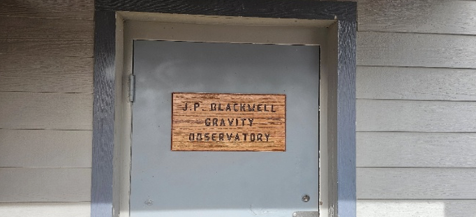
First, a special shout-out to my dear friend and former colleague, Juliana Blackwell, retired Director of the National Geodetic Survey. NOAA’s Table Mountain Gravity Observatory in Boulder, Colorado — long known for its absolute gravity work — has been officially renamed the J. P. Blackwell Gravity Observatory. This well-earned tribute honors her outstanding dedication and visionary leadership at NGS. Congratulations, Juliana!
J. P. Blackwell Gravity Observatory. (Photo: NGS)J. P. Blackwell Gravity Observatory. (Photo: NGS)J. P. Blackwell Gravity Observatory. (Photo: NGS)
NGS employees participated in the following sessions and meetings during GeoWeek 2026:
ASPRS NSRS Modernization Working Group Meeting
NSRS Modernization — The Latest Technical Updates
Preparing to Put the Modernized National Spatial Reference System into Practice
Roundtable — NSRS Modernization and Professional Societies
As President of the American Association for Geodetic Surveying (AAGS), I participated in the session titled “Roundtable – NSRS Modernization and Professional Societies.” Dana J Caccamise II, NGS regional geodetic advisor, opened our session by describing the NGS Modernization Engagement Plan and Progress. As I mentioned last month, Dana should get an award for the material he has prepared and for his work assisting agencies and professional organizations in preparing for the new NSRS. I highlighted Caccamise’s work in my October 2025 GPS World newsletter.
All the NGS sessions provided the latest information on activities associated with NGS’s NSRS Modernization. Here are the specific questions I had going into the session, along with the clear answers provided by NGS personnel during their presentations and the follow-up Q&A:
What NGS products and services will be available when federal agencies officially adopt the new NSRS?
When the modernized NSRS is officially adopted (following FGCS approval and the transition to it becoming “the NSRS”), NGS will make available a full suite of updated tools, data access points, and services built around the new reference frames (e.g., NATRF2022 and variants), the North American-Pacific Geopotential Datum of 2022 (NAPGD2022), the State Plane Coordinate System of 2022 (SPCS2022), and associated geopotential models like GEOID2022. Key products expected to be operational and official include:
NCAT
NGS Maps
Geodetic Station Page
CORS
Geodetic Mark Page
Passive Marks
OPUS–Static 5.2
OPUS-Share
What NGS products and services will NOT be available when federal agencies officially adopt the new NSRS?
Upon official adoption of the modernized NSRS — after FGCS approval and the shift to the new system becoming “the NSRS” — several current products and services will no longer be part of the official modernized NSRS or will be discontinued in their present form. Key items not included or no longer supported in the modernized NSRS release include:
OPUS Projects 5 will not be supported
OPUS-Rapid Static (OPUS-RS) will not be supported (modernized OPUS-Static 5.2 is expected to handle a broader range of observations)
OPUS 6.0 and OPUS 6.1 will not be available
What GNSS data will be included in the first iteration of the computation of Reference Epoch Coordinates (REC) for marks?
At Geo Week 2026, NGS stated that its plans include providing Reference Epoch Coordinates (RECs) for certain legacy GNSS projects. Specifically, this includes:
GPS projects that were originally processed and published under the NAD 83 (2011) realization, and
Other GNSS projects will be officially published by NGS through the end of 2025\
After the first iteration of Reference Epoch Coordinates, is NGS planning to perform future adjustments to determine REC and SEC of new marks? If so, what process will be used to establish RECs on new marks?
Yes, NGS plans include performing future adjustments to compute Reference Epoch Coordinates (REC) for new marks. However, at this time, no final decision has been made on how often this will be performed.
Has NGS changed how users need to submit data to incorporate leveling data into NAPDG2022?
Yes, NGS has introduced changes to better integrate leveling data (differential height differences) into the modernized NSRS for computing orthometric Reference Epoch Coordinates (RECs) in NAPGD2022 (epoch 2020.00).
As documented in Blueprint Document 3, when performing leveling projects, users will also be required to occupy a number of primary marks with GNSS.
OPUS 6.1 is built for future expansion to support other geodetic measurements (classical, leveling)-no timeframe was given for this.
Is NGS planning to officially adopt the new NSRS before users can submit data to NGS for technical review and publication in the NGS database?
Yes, that is what NGS is saying at this moment (February 2026). OPUS Project 5 will not be supported and OPUS 6.1 will not be operational when the new NSRS is officially adopted.NGS is working on the OPUS 6 application and is trying to “minimize any gap in service.”
Is NGS recommending using the OPUS-Share utility until users can submit data to NGS for technical review and publication in NGS database?
Yes, that is what NGS is recommending at this moment (February 2026).
OPUS-Projects 5 will not be included in the modernized NSRS. Instead, NGS will focus on both developing an improved software suite for OPUS, known as OPUS 6.0 and OPUS 6.1, and minimizing any gap in service in which the current OPUS-Projects functionality is not available for users to organize, process, adjust, and submit high-accuracy GPS surveys for use by NGS in expanding and improving the NSRS. As noted above, OPUS-Share will remain available as a means to submit data to NGS.
When will OPUS 6.1 be available for users to submit data to NGS for technical review and publication in NGS database? Is it weeks away, months away, or years away?
NGS has not announced an official completion or release date for OPUS 6.0 and OPUS 6.1. However, they have indicated that active development is underway on this enhanced OPUS tool suite. It’s not imminent— meaning not expected within several months—but it’s also not a distant, multi-year project.
NGS is working on the application and is trying to “minimize any gap in service.”
“OPUS-Projects 5 will not be included in the modernized NSRS. Instead, NGS will focus on both developing an improved software suite for OPUS, known as OPUS 6, and minimizing any gap in service in which the current OPUS-Projects functionality is not available for users to organize, process, adjust, and submit high-accuracy GPS surveys for use by NGS in expanding and improving the NSRS. As noted above, OPUS-Share will remain available as a means to submit data to NGS.”
What’s the cut-off date for users to submit projects via OPUS Project 5 so the data can be part of future computations of RECs?
Current OPUS-Projects 5 is going to be supported until adoption of the new NSRS, with a deadline announced at least 6 months in advance.
“Note: the current OPUS Projects 5 software will be supported until the modernized system is adopted, and a deadline for OPUS-Projects users to submit their surveys for publication will be announced with at least six months’ notice.”
In the session “NSRS Modernization – The Latest Technical Updates,” the National Geodetic Survey (NGS) presented slides detailing the status and upcoming tasks for the modernized National Spatial Reference System (NSRS). Key highlights from the presentation are summarized below.
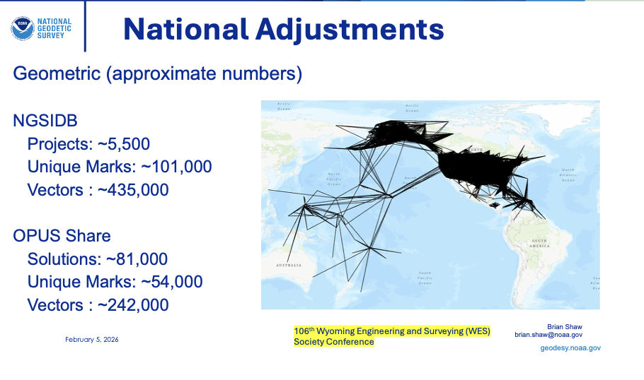
106th Wyoming Engineering and Surveying (WES) Society Conference – February 5, 2026 – Brian Shaw
2026 GeoWeek – Modernized Tools – February 17, 2026 – Brian Shaw
2026 GeoWeek – Updates to OPUS for Accessing the Modernized NSRS – February 17, 2026 – Dan Gillins
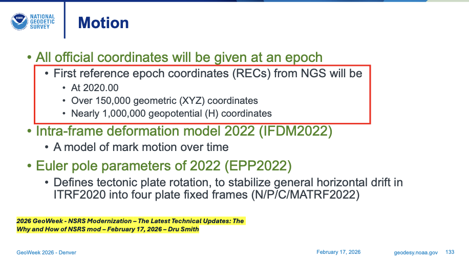
During Dru Smith’s presentation, he mentioned what will be included in the first iteration of the computation of Reference Epoch Coordinates (REC) for marks. The slide states that more than 150,000 geometric (XYZ) coordinates and 1 million geopotential coordinates (that is, orthometric heights) will get reference epoch coordinates (REC), epoch 2020.00. These will include data from NGS Integrated Database and from the OPUS Share database.
First Reference Epoch Coordinates (REC). (Presented at GeoWeek 2026)First Reference Epoch Coordinates (REC). (Presented at 106th WES Society Conference)
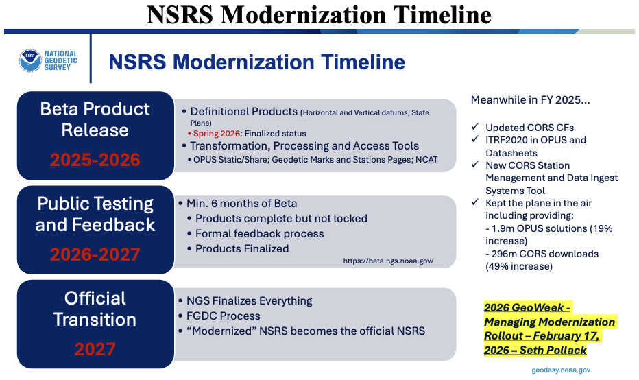
In the GeoWeek 2026 presentation by Seth Pollack (from NOAA’s National Geodetic Survey), a slide outlined the NSRS modernization timeline.
As detailed in the slide and consistent with NGS’s official rollout plan:
Beta products are currently being released incrementally on the beta site for public testing and feedback. This phased rollout began with initial beta releases in 2025 (following alpha in 2024) and continues through 2026, covering key components such as NAPGD2022, GEOID2022, SPCS2022, enhanced NCAT transformation tools, OPUS-Static updates, and forthcoming Data Delivery System features.
Each beta component, once released, undergoes public testing and stakeholder feedback, with overall testing continuing for at least 6 months after the final component is made available on the beta site.
Following sufficient testing—once all components appear stable and NGS has incorporated feedback—the Federal Geodetic Control Subcommittee (FGCS) will vote to recommend approval of the modernized NSRS. This vote is anticipated in late 2026 or early 2027.
Upon FGCS approval (and subsequent Federal Geographic Data Committee (FGDC) endorsement), NGS will probably publish a Federal Register Notice announcing the adoption. At that point, the modernized NSRS becomes the official National Spatial Reference System, replacing the legacy system (NAD 83 realizations, NAVD 88, etc.).
While earlier NGS documentation targeted adoption likely in mid-to-late 2026 (post-FGCS vote), recent updates from GeoWeek 2026 sessions and related reports indicate the full official adoption and transition may extend into the first part of 2027, accounting for final testing, FGCS/FGDC processes, Federal Register steps, and a smooth handover to avoid disruptions.
The current NSRS remains official throughout this period. Users are encouraged to test beta products now and provide feedback to help refine the system.
NSRS Modernization Timeline. (Presented at GeoWeek 2026)
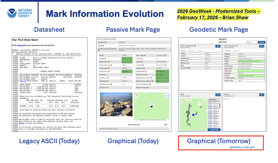
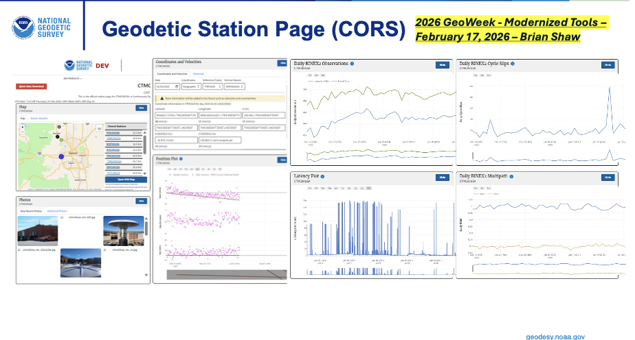
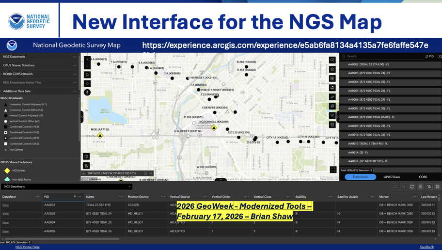
Brian Shaw, NGS’s expert on GIS products and services, presented key updates on how users will access geodetic data in the modernized National Spatial Reference System (NSRS).
He emphasized the introduction of a revamped Data Delivery System (DDS), which includes:
Geodetic Mark Pages — for passive marks. These replace the current ASCII-text datasheets with modernized, user-friendly pages featuring updated Reference Epoch Coordinates (RECs), integrated photos, graphics, maps, project details, and easier navigation.
Geodetic Station Pages — for active stations like those in the NOAA CORS Network (NCN). These provide updated versions of existing CORS pages, including modernized coordinate functions (e.g., Coordinate Functions or time-dependent positioning info) aligned with the new reference frames (NATRF2022, etc.).
Additionally, Shaw highlighted a new interface for the NGS Map (the interactive web map application), serving as an enhanced landing page within the DDS. This updated “NGS Map” (replacing or evolving the current version at https://noaa.maps.arcgis.com/apps/webappviewer/index.html?id=190385f9aadb4cf1b0dd8759893032db ) will provide better access to geodetic control data, CORS stations, and other layers, improving visualization and querying for surveyors, GIS professionals, and the public.
These changes are part of the broader DDS rollout, currently pending beta release (as of February 2026), aimed at making data more accessible, visually rich, and compatible with the modernized NSRS components (e.g., NATRF2022, NAPGD2022, SPCS2022). The DDS landing page will consolidate access, moving away from legacy datasheet formats toward dynamic, web-based delivery.
Accessing Data from NGS. (Presented at GeoWeek 2026)Accessing Data from NGS. (Presented at GeoWeek 2026)Accessing Data from NGS. (Presented at GeoWeek 2026)
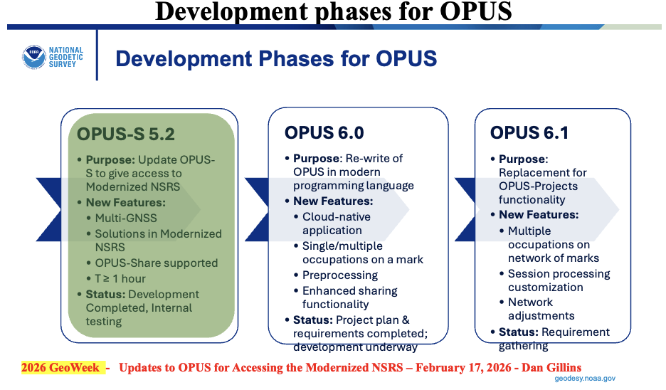
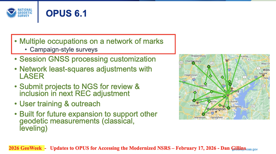
During Dan Gillins presentation he highlighted that NGS has three development phases for OPUS underway to support the Modernized NSRS:
OPUS-S 5.2:Multi-GNSS with similar functionality as current OPUS-S
Occupations – one hour or greater
Standard deviations estimate instead of peak-to-peak values
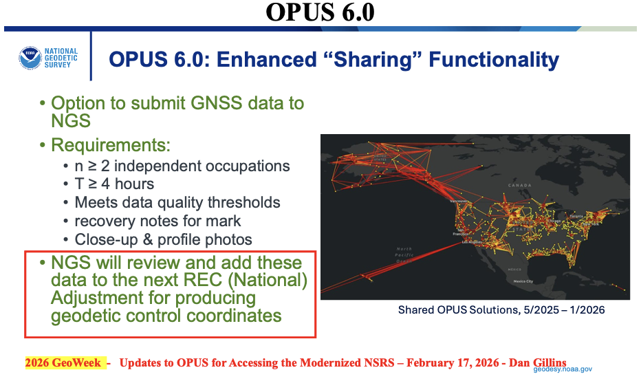
OPUS 6.0:Rewrite of code base in cloud-native application
single/multiple occupations on a single mark
enhanced sharing functionality
Occupation Time – minimum of 4 hours
NGS will review and add these data to the next reference epoch coordinate (REC) adjustment
OPUS 6.1: Extension of OPUS 6.0 for multiple marks in a network
Replace OPUS-Projects functionality
Multiple occupations on a network of marks (campaign-style surveys)
Will allow multiple occupations on a single mark – uploads ~10 data files on a mark
Built for future expansion to support other geodetic measurements (classical, leveling)
I want to emphasize that, in my opinion, NGS is doing a fantastic job with the limited resources that they have. That said, I still have an issue with adopting the new NSRS without having a process for users to submit data to NGS for review, approval, and publication by NGS. This may not be an issue if NGS’s OPUS 6.1 is available soon after the new NSRS is adopted by the Federal Agencies.
My August 2025 GPS World Newsletter discussed the OPUS products under development and, as I mentioned at that time, in my opinion, may be a problem for some users. As I stated in my August newsletter, for the new NSRS to be successfully implemented by users, it is essential that all the necessary software tools are available to enable users to submit projects for review, approval and publication by NGS.
“The NGS News announcement provides a list of products that will be available and a list of products that will not be available when the new NSRS is adopted. Users need to understand what products will not be available after NGS officially adopts the new NSRS so they can determine what that means to their workflow process and client requirements. In my opinion, for the new NSRS to be successfully implemented by users, it is essential that all the necessary software tools are available to enable users to submit projects for review, approval, and publication by NGS. As many of you know, when I worked for NGS, I was the Project Manager of the North American Vertical Datum of 1988 (NAVD 88). That said, from my experience as the NAVD 88 Project Manager, having the appropriate tools available was important for users to implement NAVD 88. As a matter of fact, NGS accepted and processed vertical control data in both NGVD 29 and NAVD 88 for a period to assist users in the implementation of the new vertical reference datum.”
NGS does state that users will be able to submit data through OPUS and OPUS Share to obtain estimates of coordinates in the new NSRS. Unfortunately, using OPUS-Share results that are NOT official NSRS coordinates published by NGS could lead to confusing results and potential lawsuits since NGS does not stand behind the results and recommends NOT using OPUS-Share results for geodetic control.
“This is NGS’s statement on OPUS-Share: Additionally, the popular function of “sharing” your solution with others (colloquially called “OPUS-Share”) will be retained, but with appropriate caveats that the shared solution should not be used as geodetic control. These shared solutions will be available through the geodetic mark pages of the DDS.“
Why should users use OPUS-Share to establish geodetic control when NGS advises against relying on OPUS-Share for establishing geodetic control? OPUS-Share results are not officially submitted to NGS for review, approval, and publication on an NGS Datasheet. I don’t believe this approach will meet the needs of users who require their projects to be reviewed, approved, and published by NGS.
Finally, as someone deeply invested in the geodetic community—having retired from NGS and followed NGS developments closely for years—my overall opinion on the NSRS modernization rollout plan for the remaining products is cautiously positive, but with some genuine concerns that I believe NGS and stakeholders should address head-on to ensure a smoother transition.
The phased beta release approach (starting in 2025 and continuing through 2026) is smart and user focused. Releasing components incrementally on the beta site, allowing at least 6 months of public testing and feedback per major piece (and overall testing extending beyond the final release), shows NGS is prioritizing stability over speed. The emphasis on stakeholder input, FGCS approval (now looking like late 2026 or early 2027), and a multi-month transition to the official site align well with best practices for such a massive shift. It’s encouraging to see private industry partners (e.g., ESRI, Blue Marble) already engaging deeply and planning implementations—success will depend on industry buy-in.
That said, here are my main thoughts and concerns I’d share directly with NGS (perhaps via [email protected], user forums, or upcoming webinars/Q&A sessions):
Timeline uncertainty: Clearer, more frequent milestone updates (beyond the Track Our Progress page) would help manage expectations. For example, monthly or bimonthly “status dashboard” with remaining beta items and projected release windows would be invaluable.
OPUS and processing continuity: The shift away from OPUS-Projects 5 toward OPUS 6 and OPUS-Share is logical for a modern GNSS-centric system, but the lack of a firm end-of-support date for legacy OPUS tools (beyond “at least 6 months’ notice”) creates planning headaches for firms with ongoing projects. NGS should commit to a longer grace period—or ideally a defined parallel support window—for legacy OPUS tools (particularly OPUS-Projects 5) after the official adoption of the modernized NSRS.
Data access and usability in the new DDS: The revamped Geodetic Mark/Station Pages, updated NGS Map interface, and overall Data Delivery System sound promising (more visual, integrated RECs/SECs, photos, etc.), but surveyors rely heavily on reliable, scriptable access (e.g., for bulk queries or automation). If the new web-based system lacks robust APIs or export options comparable to current datasheets/legacy tools, it could hinder efficiency. Beta testers should push hard on this during the 6+ month window.
Transformation tools and legacy data handling: Enhanced web-based tools are key for bridging old-to-new (NAD 83/NAVD 88 to NATRF2022/NAPGD2022), but users need confidence that transformations minimize errors, especially in deformation-prone areas.
Communication and outreach: NGS has improved with webinars, the Presentations Library, and beta feedback channels, and more targeted outreach to state agencies, professional societies (NSPS, AAGS), and software vendors has helped. That said, many in the field still feel “in the dark” about practical impacts—case studies, training resources, and FAQs tailored to common workflows would go far.
In summary, the plan is thoughtful and deliberate, reflecting lessons from past delays. If NGS maintains transparency, incorporates feedback aggressively during beta, and ensures vendor readiness, the modernized NSRS will be a major win for accuracy, sustainability, and GNSS alignment.
I’d encourage anyone reading this (including NGS staff) to test the beta products actively, submit detailed feedback, and participate in forums/Q&As. The community input will make or break the success of this once-in-a-generation update.
Oscilloquartz has entered a joint technology validation with Tupaia, demonstrating how mobile operators and enterprises can achieve high-accuracy GPS positioning using existing timing infrastructure.
The validation, conducted through a real-world drive test across mixed highway and semi-urban environments, confirms that Oscilloquartz grandmasters can integrate with Tupaia’s cloud services to enable advanced positioning without dedicated, standalone reference-station networks — reducing deployment complexity and cost.
“This collaboration shows what’s possible when precise timing infrastructure is combined with cloud-based positioning intelligence,” said Nadav Lavi, CEO of Tupaia. “By integrating Tupaia’s cloud service with Oscilloquartz’s installed base, mobile operators can immediately offer centimeter-level positioning to commercial users across applications such as the Internet of Things, drones, automotive and logistics.”
During the validation, positioning results from a single GPS device were compared against calculations made by Tupaia’s cloud service using Oscilloquartz grandmasters. Tupaia’s cloud-based navigation consistently reduced typical multi-meter GPS errors to centimeter-level accuracy throughout the drive.
The test also demonstrated a flexible deployment model in which Oscilloquartz grandmasters can function as both reference stations and rovers, allowing high-precision positioning services to be layered onto existing timing networks without additional infrastructure.
“Mobile operators are increasingly looking to extract more value from infrastructure they already trust and operate,” said Gil Biran, general manager of Oscilloquartz. “This validation shows how our grandmaster platforms can be extended beyond synchronization to support advanced positioning use cases, enabling new revenue-generating services while preserving existing network architectures.”
Biran added that building on deployed timing assets allows operators to accelerate the rollout of high-precision positioning while avoiding the cost of installing new antennas or dedicated positioning equipment.
Hexagon | NovAtel has joined the GPS Innovation Alliance (GPSIA) as its newest member.
NovAtel develops positioning, navigation and timing (PNT) products for land, sea and air applications, with users in agriculture, defense, autonomous mobility and marine sectors. The company’s portfolio includes high-precision GNSS receivers, correction services, sensor fusion systems, GNSS anti-jam technology and post-processing solutions.
GPSIA Executive Director Lisa Dyer said the addition comes at a critical time for PNT infrastructure.
“NovAtel brings world-class expertise in high-precision GNSS, inertial integration, and anti-jam capabilities that help protect critical services people rely on every day, from transportation and public safety to the supply chains and infrastructure that power the world’s economy,” Dyer said. “Their leadership will strengthen GPSIA’s work to protect GPS and complementary PNT technologies from harmful interference and to accelerate the innovation that underpins the decades-long reliability of these systems.”
Jonathan Auld, president of NovAtel’s Positioning Division at Hexagon, said the company plans to use its membership to raise awareness of PNT’s role in critical industries.
“From precise positioning and correction services to resilient solutions that help mitigate interference, we support customers operating in mission- and safety-critical environments,” Auld said. “We look forward to working with GPSIA to heighten awareness of the role these technologies play in innovation, critical infrastructure, and economic growth.”
NovAtel joins existing GPSIA members Apple, Garmin, Deere & Company, Lockheed Martin, Trimble and TrustPoint, along with organizations participating in the alliance’s affiliates program. GPSIA describes its mission as protecting, modernizing and advancing GPS, GNSS and complementary PNT technologies.
SparkFun Electronics has released the SparkPNT TX2, a quad-band GNSS rover that combines an IP67-rated aluminum enclosure with support for Galileo’s High Accuracy Service (HAS) and standard RTK correction workflows.
The receiver is built around the Quectel LG290P quad-band GNSS engine and supports multi-constellation tracking. Galileo HAS support provides sub-20 cm accuracy globally without subscription-based correction services, while RTK workflows via NTRIP or u-blox PointPerfect can achieve centimeter-level positioning.
Battery life is rated at 50-plus hours, positioning the TX2 for multi-day field campaigns without recharging. The unit connects to iOS and Android devices via Bluetooth and Wi-Fi, with compatibility reported for common GIS and data-collection applications.
A notable design choice is the open-source firmware, which gives users visibility into how positioning data is processed and allows for customization and third-party integration. SparkFun has positioned this as an alternative to closed GNSS ecosystems where firmware and processing pipelines are not user-accessible.
Crowded cities with stacked road systems and reflective architecture may offer impressive skylines, but for GNSS receivers, they create some of the harshest conditions on Earth. For technologies that depend on stable, trustworthy positioning, real-world testing in these challenging environments is essential. Here, Jez Ellis-Gray, product manager at Focal Point Positioning, a provider of GNSS positioning software, examines what recent field deployments reveal about the future of reliable GNSS.
Urban environments present unique constraints that no laboratory or simulation can perfectly replicate. A lab test may miss the thousands of variables that influence signal behaviour in a living, breathing city or a dense forest road. This matters most for automotive applications, where positioning must remain stable and trustworthy to support driver assistance and higher levels of automation. That is why we conducted field trials across Germany and Japan, evaluating FocalPoint’s S-GNSS Auto software running on STMicroelectronics’ Teseo GNSS receivers in challenging real-world conditions.
This testing demonstrated that GNSS performance in the real world is often determined not by peak accuracy under ideal conditions, but by the system’s reliability when satellite signals are distorted, reflected or partially obstructed.
This distinction — between accuracy and reliability — is becoming increasingly important for sectors where positioning plays a safety-critical role, including automotive.
Understanding the complexity of real environments
Germany’s combination of modern architecture and medieval street layouts made it a good place to test GNSS upgrades against standard technology. A city like Frankfurt offers a nice mix of glass facades, narrow streets and tall buildings – conditions that tend to create multipath interference.
During our recent field testing, conventional GNSS receivers frequently suffered from severe degradation of position accuracy when compared to a state-of-the-art ground truthing system. The standard receiver positions will often drift away from the travelled path, often through buildings or even onto parallel roads.
As accuracy deteriorates, the receiver can usually tell that the input information is poor, and output a warning for a larger estimate of error. This is a useful warning flag for AVs and allows for safe handover back to the human driver. However, in some cases, the reflected signals cause the miscalculation to be assumed correct. This “confident but wrong” GNSS is a much greater threat to autonomous driving, as the vehicle may make a dangerous decision based on this false information.
In contrast, the S-GNSS Auto enhanced receiver was able to maintain lane-level accuracy far longer, even in areas where intense reflections would normally overwhelm the satellite data. In multipath-heavy environments, S-GNSS on Teseo receivers showed an accuracy improvement of up to 4x. These findings reinforced our belief that, as automation increases, consistency and reliability will be more valuable than peak accuracy.
A navigation system that performs well on open motorways but struggles on urban roads will not scale safely to higher levels of vehicular automation. This is particularly relevant as the industry transitions from Level 2 to Level 3 autonomy, marking the point at which a vehicle takes full responsibility for the driving task in defined conditions, allowing the driver to disengage temporarily while the system manages safety-critical decisions.
This shift is expected to unlock significant commercial value. A 2023 report by McKinsey predicted that advanced driver assistance and autonomous driving features could generate between $300 billion and $400 billion in annual revenue by 2035, driven by software services and subscription-based functionality that depend heavily on reliable positioning. Unlocking this potential will depend on the next generation of vehicles having robust positioning systems, as users are unlikely to pay ongoing subscriptions to systems that repeatedly require human intervention or where safety concerns linger.
Japan: one of the world’s most challenging environments
If Germany represents a demanding test bed, Japan pushes GNSS to the extreme. Tokyo offers some of the toughest conditions anywhere in the world due to its towering buildings, multilevel road networks and narrow corridors that create intense multipath environments, so it was a natural choice for our next field test.
The results showed that in particularly dense districts such as Shinjuku, standard GNSS receivers often struggled to maintain a coherent position solution. Reflections from glass towers, elevated highways and rail lines produced non-line-of-sight signals that overwhelmed conventional algorithms.
S-GNSS Auto, integrated onto STMicroelectronics’ Teseo receivers, demonstrating improvements in vehicle positioning accuracy. (Data from Shinjuku, Tokyo)
However, receivers equipped with S-GNSS’s advanced signal-processing techniques demonstrated significantly improved performance. These upgraded devices maintained a stable positioning where traditional systems faltered, avoiding errors that would cause an automated system to disengage or provide dangerously erroneous positions
This improved reliability has direct implications for safety and user experience, which vehicle OEMs will no doubt welcome. In driverless vehicles, GNSS problems that trigger sudden driver handovers or interruptions to hands-free modes, are likely to erode trust and reduce the likelihood of subscription renewals, as the end user will judge the product less by its peak performance and more by its dependability in everyday situations.
Field testing and the future of positioning technology
As cities evolve, buildings grow taller and mobility systems become more congested, the challenges facing GNSS will only increase. As such, automotive OEMs are rightly starting to demand real world results, not just in ideal conditions (static, open sky) but in the worst conditions.
Manufacturers increasingly recognise that positioning is now a foundational technology that underpins safety, automation and customer experience. Investments in more reliable GNSS systems are therefore not marginal enhancements but essential enablers of future services. For companies developing navigation and sensing technology, real-world testing offers a unique opportunity to understand how systems react to chaotic, imperfect environments. It provides granular insight into where and why positioning fails, and how these software-based enhancements can bridge the gap. By validating these solutions in the world’s toughest GNSS environments, developers can offer manufacturers greater confidence in deploying advanced features across global markets.
You can request an evaluation kit here or download the full results report of our latest testing here.
We just finished the year that marked the 30th anniversary of America’s Global Positioning System (GPS) reaching full operational capacity. What began as a military tool to enable U.S. military forces to navigate more precisely and to support the use of precision strike weapons anywhere in the world has become the invisible infrastructure that powers nearly every aspect of civilian life. So much of our everyday lives, from smartphones and ATMs to aviation, shipping and Wall Street, run on precise timing and location information.
However, that infrastructure is now under duress. Our adversaries are waging a sophisticated war on GPS signals, and the fallout is both significant and frightening. Reports of navigational issues across the Baltic and the Middle East have become a daily occurrence due to conflicts in the region. The impacts have extended into civilian life, impacting air, land and sea.
It’s a miracle the regions have avoided a major aviation disaster, given that navigational warfare and space have become new domains of nation-state confrontation. Russia is spoofing and jamming signals across Eastern Europe. Russia and China are also shadowing military and civilian satellites, performing dangerous dogfighting maneuvers in orbit.
Jamming and spoofing were once rare. Now, they are battle-tested tools in the electronic warfare arsenal, and the U.S. is not immune to their effects. What’s happening in these regions today could happen over Chicago or Atlanta tomorrow.
Similar interference has been detected near major U.S. airports, including Dallas and Denver, impacting nearly 350 flights. Nation-states were not responsible for these incidents, but they prove how vulnerable GPS is to disruption.
This isn’t a Hollywood thriller. A coordinated attack on GPS would ripple across aviation, finance, emergency response, and daily life within minutes, not days. We’ve already seen how quickly systems collapse when digital links are severed.
In 2022, a volcanic eruption in Tonga severed the country’s only undersea cable and blocked satellite signals, plunging the island into an instant blackout. Commerce broke down, and government emergency coordination collapsed. ATMs couldn’t dispense cash because banks couldn’t confirm account balances. Cargo planes couldn’t file manifests, and supply chains froze. Farms and fisheries couldn’t complete online forms, so produce rotted. Pharmacies couldn’t fill prescriptions because their supply systems were offline. The effects were immediate and took months to normalize.
If GPS goes down, whether because of jamming, spoofing, a cyberattack or a natural disaster America is dangerously unprepared. Our widespread reliance on a vulnerable technology should be a wake-up call. A single sustained outage could cost the U.S. economy an estimated $1.6 billion per day.
When I served as commander of U.S. Cyber Command, our team was responsible for ensuring the networks underpinning our military missions were fully operational and secure, and as the director of the National Security Agency, the team was focused on generating deep knowledge of threats to the U.S. and allied operations across land, sea, air, space and cyberspace. In both roles, it became very clear that we needed to protect our positioning, navigation and timing infrastructure, and that one of the keys to doing so was to create layered resilience.
Solving a problem of this magnitude is a massive challenge. But we don’t need to start from scratch. By leveraging existing infrastructure in space and on the ground, we can accelerate deployment, reduce cost and avoid duplication. Speed and scale are essential. It’s not a question of whether the U.S. experiences a major GPS disruption, but when.
Fortunately, the technology already exists. American companies are developing methods to provide positioning, navigation and timing backup via terrestrial 5G networks, offering timing and location signals that are independent of satellites. These solutions are scalable, cost-effective and designed to integrate directly into existing telecom infrastructure such as cell towers. If commercial providers are already exploring complementary backup technologies, why are we still lagging behind our adversaries?
The real barrier isn’t technology — it’s policy. Moving the process forward to make these technical capabilities a reality is the challenge. Getting government bureaucracies to act with urgency is never easy, but the administration and Congress now recognize the stakes.
The Federal Communications Commission has launched an inquiry into strengthening national positioning, navigation and timing infrastructure, including exploring ground-based alternatives such as 5G-powered systems. Now it’s time to follow through and move from planning to execution.
The threats are real; the technology is ready; and the cost of inaction grows by the day. Replacing GPS is not a realistic near-term solution, either in terms of cost or the time frame required to do so. Our focus should be on building a layered, resilient system that provides users with multiple options to react to loss or degradation of our current positioning, navigation and timing structure. One layer of that system should be a ground-based component that takes advantage of the existing infrastructure already in place, saving us significant time and money in creating a solution to this critical problem.
Several interesting things, according to geologists who study data from the global network of geodetic-quality receivers. A team at the University of the Basque Country found the Iberian Peninsula rotating clockwise as Africa closes on Eurasia by 0.2 inches per year (5 mm), near Gibraltar and the Alboran region. Meanwhile, in a process called lithospheric dripping, Earth’s crust is sinking under Central Turkey despite being part of a broader region that has been uplifting for millions of years, according to University of Toronto researchers. Meanwhile, in the U.S. Pacific Northwest, seismic data collected during a National Science Foundation study shows the Cascadia subduction zone actively breaking apart.
Making better robots with GNSS
Image: Robosat Project
Autonomous robot navigation in the wild using satellite-based 3D geographical information (Robosat) aims to provide a scalable multi-GIS high-quality data collection platform through using a quadrupedal robot that can autonomously perform long-distance missions in challenging environments, such as the Alps or Finnish forests. Researchers from Finland, Switzerland, Spain and Romania gathered at Tampere University in Finland to share data, identify relevant GIS and GNSS datasets, and leverage AI for autonomous labeling of large-scale data. Key topics included integrating multi-sensor and multi-GIS data to enhance positioning, planning pilot tests with ETH’s ANYmal robot (pictured) and TAU’s new I/Q GNSS grabber device, and discussing methods for AI-driven data labeling for massive datasets collected in field trials.
It’s all happening downtown
Image: Getty Images / Ivan Pantic
Researchers from Shandong Jianzhu University and the China University of Mining and Technology describe a new smartphone positioning strategy in the Dec. 15, 2025, issue of Satellite Navigation. They use a positioning framework that combines 3D map constraints with multiple GNSS observations. By integrating time-differenced carrier-phase information with probabilistic road matching and factor graph optimization, the approach reduces ambiguity in candidate positions and enhances robustness against non-line-of-sight signals. In field tests, the method outperformed existing smartphone GNSS techniques, delivering more reliable location estimates and smoother trajectories even in severe urban canyon conditions.
2,000 and counting
Image: Getty Images / rvimages
The International Air Transport Association (IATA) has called for vigilance following the increasing number of GNSS spoofing and jamming incidents worldwide. The growing interference poses a significant risk to flight navigation and pilot safety. Of note is a spike in incidents at major Indian airports. Almost 2,000 GNSS interference incidents have been logged at airports in India since 2023, including the airports in Delhi, Mumbai, Kolkata, Amritsar, Hyderabad, Bengaluru and Chennai. IATA represents more than 360 airlines, accounting for 80% of global air traffic.