Author: Jesse Khalil

  • Leica Geosystems unveils machine smart antenna

    Leica Geosystems unveils machine smart antenna

    Photo: Leica Geosystems
    Photo: Leica Geosystems

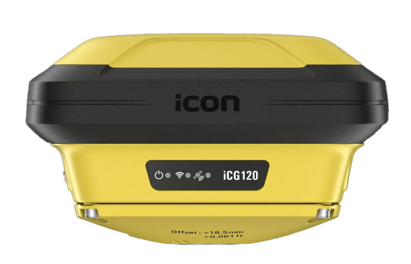
    Leica Geosystems, part of Hexagon, has released the iCON 120 machine smart antenna, designed to deliver scalable and flexible machine control solutions for construction professionals.

    The iCON 120 is a GNSS antenna intended for integration within the existing Leica MC1 platform, extending the company’s machine control solution offering to cover more applications and machine types.

    With increasingly stringent project budgets and specification requirements, it is essential to incorporate intelligent solutions at every stage in major construction operations. Rationalized and connected hardware and software are being used to increase productivity, efficiency and safety, responding to the rising demand for adaptable, easily accessible and customizable machine control systems.

    Many construction machines, such as compaction rollers, generally operate at only sub-meter accuracy, without heading. With the new iCON 120, operators can benefit from a tailor-made, Leica MC1-based machine control, allowing for more streamlined operations and consistent workflows with a variety of heavy construction equipment and application requirements.

    Leica iCON 120 users can start with a single GNSS solution using a satellite-based augmentation system (SBAS), such as WAAS or EGNOS, or a HxGN SmartNet service. The HxGN SmartNet family offers network real-time kinematics (RTK) with RTK bridging and precise point positioning (PPP) services that work exclusively with Leica Geosystems GS sensors. The new smart antenna can be easily switched, with quick mounting and dismounting, between Leica MC1-prepared machines.

    Users can optionally upgrade their basic-level machine-control solution with the Leica CR50 communication unit to receive RTK correction data via radio or modem. The CR50 features a web interface, automotive ethernet communication, worldwide cellular modem and integrated dual-frequency UHF radio.

  • Emlid, Pix4D launch mobile terrestrial scanning kit

    Emlid, Pix4D launch mobile terrestrial scanning kit

    Photo: Emlid
    Photo: Emlid

    Emlid has launched the Pix4D & Emlid Scanning kit. The kit combines advanced photogrammetry with real-time kinematics (RTK) precision for quick data capture when documenting trenches and as-builts, performing volumetric measurements and enhancing aerial data with terrestrial scans. It includes the PIX4Dcatch app and the Emlid Reach RX RTK rover.

    The PIX4Dcatch app is at the core of the kit’s software, which allows precise scanning for both photogrammetry and lidar projects. The hardware part features the Emlid Reach RX RTK rover, which is equipped with an ergonomic handle and accessories.

    It is integrated with PIX4Dcatch and provides real-time positioning via NTRIP. To begin scanning, users can select Emlid in the RTK settings of PIX4Dcatch and add their NTRIP network credentials.

    The kit works with any correction network (NTRIP) or a GNSS base station broadcasting RTCM3. The rover gets a fix in less than five seconds, offering centimeter-accurate positioning in challenging conditions. Apart from the scanning tasks, it can be used with the survey pole as an RTK rover for data collection and stakeout.

    Designed for urban surveying, the Reach RX rover is lightweight, rated IP68, sealed and protected from water and dust and features an industrial-grade battery, which offers 16 hours of work on a three-hour charge.

    The solution does not require additional setup or surveying skills. It is designed for professionals and non-surveyors in a range of applications, including underground utility documentation, construction inspection, volumetric measurements, crash reconstruction and combined aerial and terrestrial surveys.

    The PIX4Dcatch mobile app allows users to use a smartphone for scanning, access RTK precision data through integration with Reach RX and generate a digital model within minutes. Users can also store, annotate, measure and share data online in PIX4Dcloud as well as verify geolocated positions and visualize the project in AR. It extracts insights from both terrestrial and aerial data and features online and offline processing, advanced photogrammetry capabilities, team collaboration and AR for CAD overlays.

  • VIAVI launches resilient PNT solution

    VIAVI launches resilient PNT solution

    Photo: VIAVI Solutions
    Photo: VIAVI Solutions

    VIAVI Solutions has released SecurePNT 6200 with SecureTime services, to enhance the resilience and precision of positioning, navigation and timing (PNT) for infrastructure operations globally.  

    The solution integrates the Fugro AtomiChron timing service, to improve security against emerging threats to global infrastructures, such as 5G networks, transportation systems and financial services. 

    SecurePNT 6200 offers a multi-source PNT service that combines signals from various orbital positions — geosynchronous (GEO), low-Earth Orbit (LEO), and medium-Earth Orbit (MEO) — with traditional GNSS constellations, offering a zero-trust, multisource assurance framework. This setup is designed to protect against the vulnerabilities of public GNSS signals, which are critical for the timing and synchronization of essential services that can be disrupted by jamming, spoofing or satellite attacks. 

    The SecurePNT solution incorporates several key technologies to ensure robust protection: 

    • Anti-spoofing: Detects and mitigates spoofing attacks, ensuring the integrity of navigation and timing data. 
    • Authentication: Extends beyond the Galileo Open Service Navigation Message Authentication (OSNMA), offering enhanced security measures across all GNSS constellations. 
    • Encryption: Protects the integrity and confidentiality of PNT data transmission. 
    • High accuracy: Delivers timing accuracy of less than 5 ns, with an optional upgrade to less than 1 ns, all traceable to UTC/NIST standards. 

    SecurePNT 6200 can be easily integrated into existing systems. It features VIAVI’s µTranscoder technology, which allows users to upgrade their legacy GPS/GNSS systems effortlessly. This technology allows a simple retrofit of the SecurePNT 6200 between an existing GPS/GNSS antenna and its receiver to improve resilience without the need for extensive hardware modifications. 

    The solution aligns with various government and industry standards, ensuring compliance with the latest guidelines from the Department of Homeland Security (DHS),   

    National Institute of Standards and Technology (NIST) and other regulatory bodies. SecurePNT 6200 aims to support the security and operational needs of critical infrastructures worldwide.

  • Syntony GNSS, Keysight partner for GNSS testing and simulation

    Syntony GNSS, Keysight partner for GNSS testing and simulation

    Keysight
    Photo: Keysight

    Syntony GNSS has partnered with Keysight Technologies, an RF testing solutions manufacturer, to advance GNSS testing and simulation capabilities.

    The collaboration centers on Keysight’s VXG advanced signal generator, which can generate thousands of simultaneous signals across all GNSS constellations and bands. It features time and phase synchronization for high fidelity and accuracy in simulation scenarios. This feature is particularly crucial for testing GNSS receivers under various conditions to ensure optimal performance in real-world scenarios.

    The Syntony GNSS Simulator Constellator can mimic the complex dynamics of GNSS signals, providing a platform for testing and validating GNSS receivers. When combined with Keysight’s VXG, it serves as a comprehensive testing solution for all GNSS signals and scenarios.

    The partnership aims to improve Controlled Reception Pattern Antenna (CRPA) testing. CRPA is pivotal in enhancing the resilience of GNSS receivers against interference and jamming to offer reliable operation even in adverse conditions. The combined solution from Syntony GNSS and Keysight offers a platform for testing CRPA systems to ensure they meet the stringent requirements of modern applications.

    Telecommunications, among other sectors, relies heavily on precise timing information, typically derived from GNSS signals. The threat of jamming attacks, which can disrupt GPS time synchronization, poses a significant risk, potentially crippling communications and other dependent systems. The testing solutions emerging from this partnership provide a toolset for infrastructure managers to evaluate and enhance the resilience of their systems against such threats.

  • Rohde & Schwarz, XipLink partner for intelligent multi-orbit networking

    Rohde & Schwarz, XipLink partner for intelligent multi-orbit networking

    Photo: ipoque
    Photo: ipoque

    ipoque, a Rohde & Schwarz company and provider of deep packet inspection (DPI) software for networking and cybersecurity solution providers, has entered a technology partnership with XipLink, a global technology that provides optimized, secure and intelligent multi-path hybrid networking.

    Under the partnership, ipoque will integrate its DPI technology, R&SPACE 2, into the XipLink operating system (XipOS) to create the XipLink Application Classification Engine (XipACE). This technology is designed to deliver advanced application visibility for multi-orbit networking.

    Layer 7 visibility for multi-orbit networking

    Using standards-based space communications protocol specifications (SCPS) protocol acceleration, link bonding, Layer 2 switching and Layer 3 routing, XipLink offers intelligent multi-orbit networking that ensures network performance and quality of service QoS across satellite, cellular and wireless networks. Embedding the next-gen DPI software R&SPACE 2 introduces traffic visibility up to Layer 7 and beyond, powering the traffic aggregation and optimization algorithms used by XipLink.

    R&SPACE 2 combines behavioral, statistical and heuristic analysis with metadata extraction to identify protocols, applications and application attributes in real time.

    “Our breakthrough AI-based encrypted traffic intelligence, which includes machine learning and deep learning techniques, and high-dimensional data analysis, brings traffic awareness to the next level by identifying any type of IP traffic, despite encryption, obfuscation and anonymization,” said Martin Mieth, P.hD., vice president of engineering at ipoque.

    Offers high-performance networks

    By integrating R&SPACE 2, XipACE can augment quality of service (QoS) management, traffic analytics, steering decisions, load balancing and dynamic link bonding. R&SPACE 2 also features an extensive feature and plug-in set, such as first packet classification, customizability of app signatures or tethering detection.

    Insights from R&SPACE 2 allow XipOS to support network diversity and resilience, from offloading traffic from congested pathways to tapping into GEO satellites to alleviate latency issues. At the policy level, it enables application prioritization and SLA compliance.

    As more and more applications require high bandwidth and low latency, the granular traffic analytics offered by R&SPACE 2 can help users optimize their networks and improve resource efficiency. These insights seek to lay the foundation for autonomous and self-healing networks through data-driven decision-making.

    The technology is designed for mobile, satellite, maritime, government and defense sectors, as well as modem OEMs.

  • Finnair cancels flights amid increased GNSS jamming

    Finnair cancels flights amid increased GNSS jamming

    Photo: Finnair
    Photo: Finnair

    Finnair, the sole international airline operating flights to Tartu, Estonia, has suspended its daily service to the city from April 29 to May 31, 2024. The decision comes in response to ongoing GNSS interferences and disruptions, including two instances where flights had to return to Helsinki, Finland, due to excessive jamming in the region.

    The current approach methods at Tartu Airport rely heavily on GNSS signals, which have been disrupted frequently in the area. To address this, Finnair plans to use the one-month flight suspension period to develop and implement alternative navigation methods at Tartu Airport that can operate independently of GNSS. Finnair aims to enhance the safety and reliability of operations, preventing similar incidents in the future.

    This suspension of flights highlights a broader issue of increasing GNSS jamming and spoofing, which has been a growing concern since the start of the Ukraine war in 2022 — specifically near Kaliningrad, the Black Sea, the Caspian Sea and the Eastern Mediterranean.

    On December 31, 2023, parts of Finland experienced significant jamming, which affected aviation and low navigation integrity reports from ADS-B systems. These were displayed on the GPSJam.org website.

    Estonian Foreign Minister, Margus Tsahkna, points to Russia as the source of the interference. Tsahkna told The Baltic News Service that jamming carried out by Russia is so dangerous that sooner or later it will cause a plane crash, ultimately endangering civilians.

  • Seen & Heard: A rise in GPS jamming

    Seen & Heard: A rise in GPS jamming

    “Seen & Heard” is a monthly feature of GPS World magazine, traveling the world to capture interesting and unusual news stories involving the GNSS/PNT industry.


    Photo: deepblue4you / iStock / Getty Images Plus / Getty Images
    Photo: deepblue4you / iStock / Getty Images Plus / Getty Images

    Rise in GPS Jammers

    The Finnish government’s Transport and Communications Agency (Traficom) has seen an increase in GNSS jamming devices. In 2024, the agency already has detected 106 GNSS disturbances caused by signal-jamming devices in vehicles. When activated, the devices interfere with GPS signals in a radius that measures from a few dozen to several hundred meters. Authorities have found people have used the jammers in company cars tracked by their employers to disrupt tachographs that track where and when they are driving.


    Photo: kertu_ee / iStock / Getty Images Plus / Getty Images
    Photo: kertu_ee / iStock / Getty Images Plus / Getty Images

    Confirmed Decline in Emperor Penguin Colonies

    A multinational research exercise has confirmed emperor penguins are in decline in Antarctica. However, the cause is still unknown. The assessment of emperor penguin colonies found a 10% decline in the adult population, now estimated at 228,000.  The study used aerial and satellite imagery of all known colonies in Antarctica to collect data for a series of models analyzing emperor penguin population processes across the continent. “Remote sensing has given us the context that, sometimes, these birds hop up on ice shelves or glaciers – we didn’t know they did that prior to seeing them doing that on satellite imagery,” said Michelle LaRue, the wildlife ecologist from the University of Canterbury and Minnesota University, who led the study.


    Image: Phillip Silverman / iStock / Getty Images Plus / Getty Images / Getty Images
    Photo: Phillip Silverman / iStock / Getty Images Plus / Getty Images / Getty Images

    UK Defense Minister’s Plane Jammed Near Russia

    A plane carrying British Defense Secretary Grant Shapps had its satellite signal jammed as it flew near Russian territory, the government reported on March 14. The government said the Royal Air Force jet carrying Shapps, officials and journalists “temporarily experienced GPS jamming when they flew close to Kaliningrad” on a flight from Poland to the UK. The Times of London, whose reporter was onboard, said that for about 30 minutes, mobile phones could not connect to the internet and the aircraft was forced to use alternative methods to determine its location. Kaliningrad is a Russian enclave bordered by Poland and Lithuania, home to the Russian Navy’s Baltic Fleet.


    Photo: lakshmiprasad S /  iStock / Getty Images Plus / Getty Images
    Photo: lakshmiprasad S / iStock / Getty Images Plus / Getty Images

    Medicine from the Sky

    In the remote village of Oren, Kisumu County, Kenya, healthcare providers are now getting supplies and medicine delivered from the sky using UAV technology from Zipline, a U.S.-based logistics company. Healthcare providers can receive deliveries via UAV in less than 10 minutes, residents told Nation. The UAV opens at the bottom and releases a box, attached to a parachute. It then flies back to the Zipline hub in Chemelil, Kenya.

  • Spirent launches PNT simulation system

    Spirent launches PNT simulation system

    Photo: Spirent Communications
    Photo: Spirent Communications

    Spirent has released PNT X, a positioning, navigation and timing (PNT) simulation system. The platform is designed to meet the escalating demands of testing complex PNT systems, which are crucial in autonomy, safety, efficiency and precision.  

     PNT X integrates a variety of signal sources including L-band, S-band and alternative navigation signals, along with Regional Military Protection (RMP) support. The system allows for the concurrent operation of multiple signals from different sources, which enhances the flexibility and efficiency of PNT testing.  

     It is tailored for future mission-critical systems including patented I/Q spatial awareness capability, an upgraded interface for controlled reception pattern antenna (CRPA) testing — the highest available continuous dynamic range for assessing jamming impacts — and a standard update rate of 2 kHz suitable for hardware-in-the-loop (HIL) simulations and high-dynamics vehicle testing. 

  • Shift5 launches GPS integrity module

    Shift5 launches GPS integrity module

    Photo:Shift5 — an onboard operational data company — has released the Shift5 GPS integrity module, a platform-agnostic solution for military, aviation, rail, maritime and space applications.

    With real-time access and analysis of onboard data, the module assesses changes in navigational position through multi-faceted anomaly detection methods, which alert operators to GPS spoofing attacks as they happen.

    Using data collected from onboard systems, the module uses algorithmic position analysis to identify significant position deviations and GPS data validation to verify GPS information accuracy. Discrepancies or deviations that indicate tampering trigger an immediate notification, allowing operators to initiate standard operating procedures (SOPs) rapidly and accurately.

    The Shift5 GPS Integrity Module is designed for cross-platform deployment, across commercial and military planes, locomotives, vessels and aircraft, as well as on other critical systems such as radar, unmanned aircraft systems (UAS) and weapon guidance systems. It seamlessly integrates with existing platforms and can deploy directly to onboard hardware.

    GPS spoofing poses significant threats to national defense and commercial transportation systems, from navigational errors to compromised operational safety — especially in contested or congested environments.

    “We are in an era of electronic warfare, defined by the use of hybrid threats on the battlefield,” said Egon Rinderer, CTO, Shift5.  “The use of cyber-physical weaponry isn’t restricted to one particular theater of conflict and isn’t aimed toward military targets alone…The answer to how we combat these types of GPS attacks comes down to data. Observability into onboard data quantifies the risk posed by GPS spoofing.”

    This technology offers multi-faceted detection and alerts for GPS spoofing attempts, designed to improve the safety and reliability of navigation systems. It uses physics-based spoofing detection to determine if changes in position are physically possible to provide an effective method for initial spoofing detection. The system analyzes data from all sources to detect subtle, sophisticated spoofing attempts, which is essential for identifying more complex spoofing strategies that may evade traditional detection spoofing techniques.

    Shift5 alerts can be integrated into existing SOPs to help preempt contamination of other positioning and navigation data, such as inertial navigation calibration against false GPS data. Metadata about the time, location, duration and estimated position of the attack can be passed for inclusion in threat mapping and other geospatial systems for future route avoidance.

  • oneNav L5-direct GNSS technology

    oneNav L5-direct GNSS technology

    Photo: oneNav
    Photo: oneNav

    oneNav L5-direct GNSS technology is the first and only commercial solution that directly acquires and tracks L5-band satellites. By fully eliminating reliance on the outdated L1 band, the L5-direct receiver is simpler, lower power, and better.  Compared to complex L1/L5 dual-band receivers:

    • L5-direct requires only a single antenna and RF chain for lower cost, smallest size and up to 3x lower power.
    • Has 8x better TTFF, and 2x more accuracy in dense urban areas.
    • Is immune to widespread L1-band jamming.

    Suitable for cellular, wearable, IOT, automotive, military, survey, and timing markets, oneNav technology is available in three distinct configurations:

      1. Licensable digital L5-direct IP core: A fully synthesizable RTL digital signal processing core includes a complete, scalable L5-direct measurement solution that has been fully simulated from 22 nm down to 4 nm.
      2. pREX SIP – Mixed signal hard macro in 22 nm GlobalFoundries silicon technology: The pREX SIP couples the L5-direct IP core with an RF front end that includes a highly optimized, low power amplifier, PLL and A/D converter. Implemented in GF22 FDX process and packaged in a SIP that can be soldered onto a PC board, or also as a hard macro for silicon platform integration.
      3. Position determination firmware:The position engine firmware converts L5-direct measurements into position, velocity, and time, and is provided as an embedded library for the platform microcontroller.

    oneNav can further customize any of these deliverables in partnership with a licensee to bring this performance to any end product. Click here to learn more.

  • Introducing Spirent PNT X simulation system

    [SPONSORED CONTENT] As developers look beyond GNSS alone to address increasingly complex positioning challenges, PNT X brings together signals including L-band, S-band, and alternative navigation signals, as well as industry-first Regional Military Protection (RMP) support, into one innovative, compact, and flexible system.

    PNT X brings together the broadest set of features and capabilities needed to protect future systems. These include the patented I/Q spatial awareness capability, an enhanced controlled reception pattern antenna (CRPA) testing interface, the highest available continuous dynamic range for jamming evaluation, and a standard update rate of 2 kHz for hardware-in-the-loop (HIL) and high-dynamics vehicle testing. Along with a host of other groundbreaking enhancements, these make PNT X the world’s most advanced test solution for NAVWAR robustness. Most importantly, it can do all this with simulation integrity delivering trusted results.

    Learn more.

    This video is sponsored content by Spirent.

  • RapidFlight launches Mobile Production System

    RapidFlight launches Mobile Production System

    Photo: RapidFlight
    Photo: RapidFlight

    RapidFlight has released its Mobile Production System (MPS), designed for the manufacturing and deployment of UAVs from forward locations.

    MPS can be owned and operated by RapidFlight or used by the US Department of Defense (DOD), its allies and defense contractors as an effective way to mass manufacture UAVs across the globe.

    A single MPS can produce 28 Group 3 aircraft per month — or much higher quantities for Group 2 and/or Group 1. Each MPS unit can be operated independently or in coordination with other MPS units by two trained technicians.

    For example, according to RapidFlight, 2,500 or more Group 3 UAVs of the same or varying designs can be manufactured in a year by deploying as few as eight MPS units. MPS are easily transported by traditional ground, sea or air vehicles.

    MPS uses commercial off-the-shelf (COTS) components for ease of global deployment and compliance with DOD requirements. They are powered via any 110v to 240v AC power source and are designed to function in the same environments in which the warfighter is deployed. MPS can handle wet, dry, hot, cold, clean, and dirty environments with operational limits currently set from -20º F to 130º F and high humidity.

    RapidFlight engineers have optimized the hardware and software technology stack specifically for MPS capabilities to give users the flexibility to quickly deploy new designs or iteratively add additional aircraft capability for constantly evolving needs.

    Additional benefits include a small logistical and operational footprint, a more resilient supply chain and minimized inventory. With multiple MPS units deployed in strategic locations, users can quickly create a distributed and resilient network of UAS production and support even in remote areas and harsh environments.