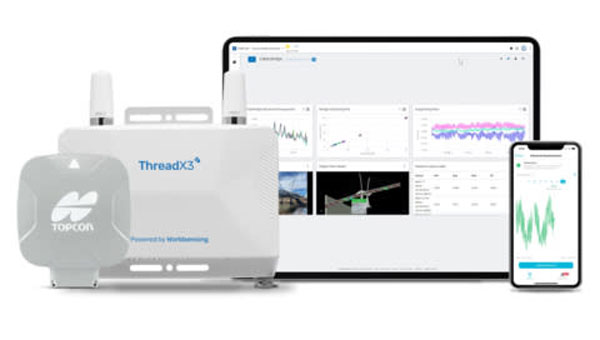
Topcon Positioning Systems has entered a strategic partnership with Bentley Systems and Worldsensing to integrate Topcon’s GNSS technology into the companies’ software and connectivity solutions to improve geospatial data accuracy and operational efficiency.
Under the agreement, Topcon’s web-based GNSS processing engine will be incorporated into Bentley’s iTwin internet-of-things (IoT) monitoring solutions, offering users real-time geospatial intelligence for better decision-making and operational effectiveness. According to Steve Bentley, senior director of infrastructure IoT at Bentley Systems, the system is designed to advance the capabilities of infrastructure digital twins.
It is a connect-and-collect solution that allows for real-time detection and analysis of potential risks. GNSS technology is the core component, which aims to make ground-movement monitoring applications more cost-effective and efficient while reducing the initial investment required for GNSS monitoring.
It is available for commercial use in the United States, Canada, Australia, Europe, the Middle East and Africa. According to Bentley Systems, the solution will expand its reach to South and Latin America.
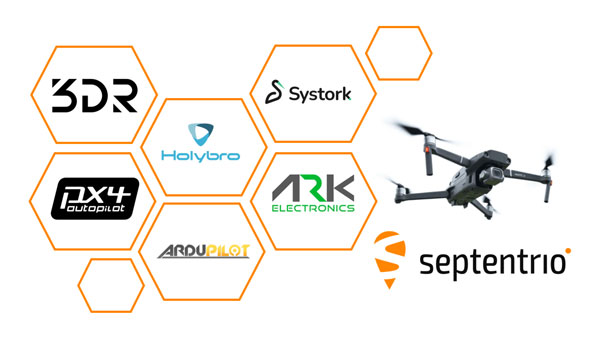
Septentrio is closely working with several UAV solutions providers including 3DR, Holybro, ARK Electronics and Systork, resulting in various new products that allow for easier prototyping or integration of the Septentrio mosaic GNSS receiver into UAVs.
mosaic is a compact triple-frequency receiver leveraging signals from all available GNSS constellations to offer the highest degree of positioning availability, even under challenging conditions. Built-in anti-jamming and anti-spoofing technology protects mosaic against intentional or unintentional interference. A high level of positioning reliability is also required by UAVs, which operate in challenging environments such as around high structures, under foliage or in places of possible RF interference. In addition to collaborations with hardware integrators, Septentrio works closely with the open-source autopilot community including PX4 and Ardupilot, which aims to facilitate a smooth integration process for end-users.
The recently available products, which are designed to bring reliable high-accuracy positioning to UAVs, include Holybro H-RTK mosaic-H (dual antenna heading), 3DR mosaic-X5 CAN GPS, Systork Linnet mosaic-X5 and ARK mosaic-x5 GPS. These products offer UAV-centered features such as magnetometer, barometer and UAV CAN communication. The integrated mosaic module receives signals from all GNSS constellations and outputs centimeter-level RTK positioning as well as full GNSS carrier raw data
Dual antenna operation is also supported with mosaic-H for heading and pitch or heading and roll orientation with sub-degree accuracy. Its anti-interference technology AIM+ is designed to protect the system from malicious jamming and spoofing attacks and reduces the risk of self-interference which occurs when nearby electronics like cameras and servos accidentally emit radio signals that interfere with GPS/GNSS.
Hexagon | NovAtel has released its 7.09.01 and 7.09.02 firmware, designed to provide improved precise point positioning (PPP) accuracy and availability for ionospheric scintillation on all OEM7 receiver boards, enclosures and SMART Antennas.
Ionospheric scintillation refers to rapid fluctuations in GNSS signal strength and phase due to localized irregularities in the electron density of the ionosphere resulting from solar activity. Scintillation adversely affects GNSS positioning particularly around the geomagnetic equator after local sunset.
Ionospheric activity is increasing as the peak of Solar Cycle 25 is approaching. To mitigate these effects, 7.09.01 and 7.09.02 firmware is designed to offer substantial enhancements to the accuracy and availability of high-precision positioning during ionospheric scintillation.
Version 7.09.01 is available for agriculture applications replacing Version 7.08.15. Version 7.09.02 is available for all other markets replacing Version 7.09.00.
Data comparing the performance of 7.09.01 and 7.09.02 to previous firmware versions showed 60% improved TerraStar-C PRO PPP accuracy during periods of ionospheric scintillation and less than 90% uptime with TerraStar-C PRO PPP in scintillation regions.
Additionally, the 7.09.01 for agriculture includes Precision time protocol (PTP) available on SMART7-I and SMART7-SI for synchronizing accurate GNSS time with other devices on a shared network. Compared to the previously released Version. 7.09.00, the system shows improvements to the time to first fix (TTFF).
Users can download the firmware updates for specific platforms at https://bit.ly/3Jr8hJi
The GEODNET Foundation has received more than $2 million of strategic investments from new investors including CoinFund, Pantera, VanEck and Santiago R. Santos. The additional funds raised will support the Foundation’s near-term objectives of decentralization and developer accessibility.
GEODNET, the company’s blockchain-based global navigation network, has more than 5,000 GNSS reference stations added to its real-time kinematic (RTK) network, designed to enhance location and intelligent autonomy services. Standard GPS is typically off by two meters; however, devices connected to GEODNET’s global RTK network are designed to achieve instant accuracy within 1 cm to 2 cm.
The network can be used in agriculture, UAVs, consumer robotic devices and commercial global positioning services such as PPP precision point positioning (PPP), automotive-focused PPP-RTK services and low-Earth orbit satellite tracking.
GEODNET has more than 4,000 registered reference stations in more than 2,500 cities across 120 countries. It is designed to provide robust precision navigation systems to a variety of industries, including self-driving cars, agriculture, consumer robots, and more. An additional 2,000 stations are being delivered and installed.
TrustPoint, a commercial GPS and navigation technology company, has been awarded a Phase II Small Business Technology Transfer (STTR) contract by AFWERX, totaling $1.6 million. The contract focuses on the development of advanced, resilient navigation applications to meet the challenges faced by the Department of the Air Force.
In collaboration with the Naval Postgraduate School, TrustPoint aims to enhance its GNSS capabilities and pave the way for applications that will boost the national defense of the United States.
The Air Force Research Laboratory (AFRL) and AFWERX have partnered to optimize the Small Business Innovation Research (SBIR) and STTR processes. Their efforts aim to provide quicker proposal-to-award timelines, broadening the applicant pool to include more small businesses and reducing bureaucratic overhead through ongoing process improvements. Since the initiation of the Open Topic SBIR/STTR program in 2018, the DAF has expanded the scope of innovations it funds, with TrustPoint’s project commencing on April 2, 2024.
Mayor Eric Adams and the New York City Department of Transportation (DOT) Commissioner Ydanis Rodriguez have introduced a new permit program designed to oversee the testing of autonomous vehicles in New York City. The program is part of the city’s initiative to ensure the safe and responsible exploration of autonomous vehicles. With safety as the primary concern, the program mandates that a trained driver must be present behind the wheel of any autonomous vehicle being tested, ready to take control at any moment.
The permit application process requires companies to demonstrate preparedness for testing in New York’s challenging urban environment through detailed plans for technology deployment and safety. This includes showcasing prior testing experience, technological capabilities and comprehensive safety plans detailing how the technology will be safely operated on city streets.
Companies interested in participating in the program must follow industry best practices for the recruitment and training of safety drivers, obtain approval from the New York State Department of Motor Vehicles, and coordinate closely with the city’s emergency services. They must also comply with cybersecurity best practices and provide detailed reports on the automation level and safety performance of their autonomous vehicles and technology.
Inertial Labs has integrated the FT Technologies FT743-D-SM Acoustic Resonance air speed sensor into its inertial navigation systems (INS).
This integration aims to improve the accuracy of horizontal air speed estimation for multi-rotor UAVs, even in GNSS-denied environments. The FT743-D-SM airspeed sensor is a digital anemometer-based solution that can estimate airspeed incoming from any direction using acoustic resonance technology, which is immune to vibration and external acoustic noise. The airspeed magnitude and direction allow the INS to estimate horizontal air speed in the longitudinal and lateral axes.
The INS receives aiding data from the dual-axis airspeed sensor and experiences significantly less position drift compared to a dead reckoning alternative in GNSS-denied environments, the company said. The system can be used in mission-critical roles in multiple military or defense applications, as well as in civilian applications such as wind energy, marine navigation, UAVs and dynamic positioning systems.
CHCNAV’s Apache USV, made of macromolecule polyester carbon fiber and Kevlar fiber-glass, can be carried by a single person. (Image: CHCNAV)
Bridges are essential components of our transportation infrastructure, facilitating seamless travel and connecting communities. The construction and maintenance of a bridge is an ongoing process, influenced by a variety of natural factors, including topography, geology, meteorology and hydrology. To protect the foundations and ensure the structural integrity of bridges, it is critical to continuously monitor bridge piers with a focus on providing consistent data support. For this project, the acquisition of 3D point cloud data of the riverbed surrounding a bridge is essential for the long-term safety monitoring of its abutments.
The Challenge of Traditional Surveying Method
Traditionally, bridge pier surveys are conducted using manned boats equipped with multibeam sonar — a method that, while mature, faces several challenges:
1. Significant safety hazards. Survey areas are prone to tidal changes, high winds, waves, and traffic from passing vessels, which can often create dangerous working conditions. Stone ridges along the riverbanks, potentially hidden during high tide, pose additional risks to manned boats surveying near bridge piers.
2. Low operational efficiency. After a typhoon, the timeline for surveying is tight. However, setting up and calibrating multibeam sonar equipment on manned boats is time-consuming. Operations in shallow areas, such as riverbanks and near central river sandbars, are limited to short periods of low tide, requiring strict adherence to schedules.
3. Poor data quality. Multibeam surveying requires overlaps of more than 20%. Accurate route keeping by manned boats, critical to multibeam surveying, is often compromised by environmental conditions and operator experience, resulting in poor data quality. In addition, GNSS signal reception under bridges is poor, affecting positioning accuracy and thus the integrity and efficiency of data collection.
4. High operational costs. The lack of specialized underwater topographic survey vessels requires the rental of traditional manned boats, which increases project costs.
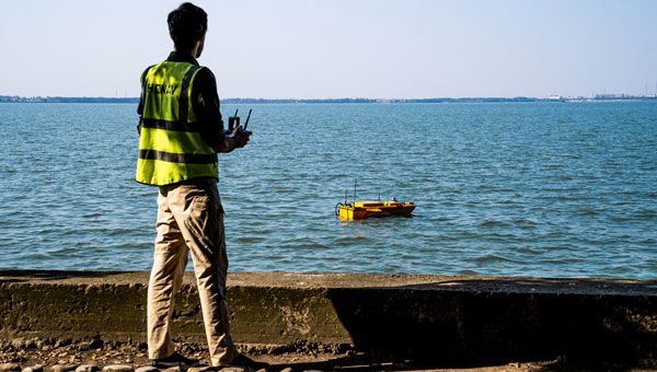
A USV can operate where it would be dangerous or inefficient for a manned boat. (Image: CHCNAV)
The CHCNAV Solution: Efficient Autonomous Surveying
To overcome these obstacles, one bridge project team implemented an innovative solution: the use of the Apache 6 unmanned surface vessel (USV) coupled with a NORBIT multibeam echosounder and an iLiDAR 3D laser scanner. This integration results in a system that is not only lightweight, compact, and easy to install and operate, but also portable and energy efficient.
The Apache 6 USV, with its all-carbon fiber hull weighing only 15 kg, combines lightness with durability. Its modular design simplifies logistics and transportation, while its ability to withstand offshore conditions and automatically follow pre-determined routes enhances operational efficiency. The system synchronizes surface and underwater data, with beams capable of scanning shallow flats and channel slopes. The echosounder and iLiDAR share position, heading and attitude data to optimize cost efficiency.
The iLiDAR 3D laser scanner features an ultra-lightweight design, with the main unit weighing less than 3 kg. Its high level of integration, requiring only a single cable for full-surface data access, and compatibility with leading multi-beam data acquisition and processing software underscore its utility.
Advantages of Using USVs
Compared to traditional manned boat surveys, the Apache 6 USV’s integration of surface and underwater sensors offers several advantages, including high integration, compact size, safe unmanned operation and lower operating costs. In addition to ensuring the safety of personnel and bridge structures, it increases survey efficiency in complex environments. Using this autonomous survey system, two project engineers were able to create a high-resolution 3D point cloud model of the riverbed scour around the bridge piers at a low operational cost. This dataset is invaluable for ongoing safety monitoring of the bridge piers, facilitating proactive maintenance and ensuring the long-term stability and reliability of this critical transportation infrastructure.
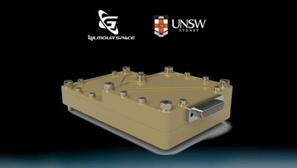
The Australian Space Agency has funded the development of an Australian aerospace-grade Global Navigation Satellite System (GNSS) receiver to use in rockets, satellites and aircraft under its Moon to Mars Supply Chain Capability Improvement Grants scheme.
Gilmour Space Technologies, in collaboration with the University of New South Wales (UNSW), will co-develop the GNSS receiver using an Australian supply chain and qualify it for use across a wide range of positioning, navigation and timing (PNT) applications. The GNSS receiver will be based on proven technology from UNSW, benefiting from Gilmour Space Technologies’ space manufacturing expertise and commercialization efforts.
Kody Cook, head of software, electrical, GNC and avionics at Gilmour Space Technologies, highlighted the importance of this initiative for the nation’s aerospace endeavors. “With the future becoming less certain, we’re thankful that Australia is investing in the sovereign development of exactly these types of fundamental capabilities,” he said. “If we could use more Australian-made avionics in our launch vehicles and spacecraft, we would.”
Inertial Labs and Sony have partnered to integrate lidar technology into Sony’s Airpeak UAV. The collaboration aims to improve the UAVs applications in surveying, mapping and cinematic videography, as well as provide high accuracy and detail to aerial data acquisition.
The partnership will incorporate Inertial Labs’ RESEPI lidar remote sensing payload instrument GEN-II into Sony’s UAV to enhance Airpeak’s ability to produce detailed aerial maps and 3D models.
Tailored for professionals, the lidar system integrated into Sony’s Airpeak drone UAVwill significantly enhance workflow efficiency and data accuracy, particularly in sectors such as construction, agriculture, and filmmaking, according to Inertial Labs. The system allows for extensive data handling and facilitates longer durations of data collection without frequent offloads.
Iridium STL is being deployed by L3Harris to protect critical FAA data center infrastructure. (Photo: Iridium)
Iridium Communications has entered a five-year agreement with L3 Harris. Under the agreement, Iridium will provide its satellite time and location (STL) service to more than three dozen L3Harris-operated communications network backbone nodes and a similar number of Federal Aviation Administration (FAA) facilities throughout the United States.
L3Harris, responsible for operating a private network for the FAA, provides voice, data and video communications for the National Airspace System operations and mission support functions. Given the critical nature of timing synchronization within the L3Harris communications network, particularly for supporting various critical infrastructure applications, the Iridium STL service plays a pivotal role in the overall network timing architecture by eliminating dependencies on GPS as the primary timing source.
The solution for L3Harris includes compact devices provided by Adtran’s Oscilloquartz division, which are designed to receive Iridium STL signals. These devices seamlessly integrate into the network and meet nationwide network timing synchronization requirements.
In April 2024, Iridium acquired Satelles, a secure satellite-based time and location service provider.
On April 4, residents of Tel Aviv, Israel, noticed that map applications on their phones such as Waze, Google Maps and the taxi pickup app Gett were placing them in Lebanon’s capital, Beirut, 130 miles to the north. Cab drivers could not navigate and food-delivery apps were temporarily out of service, reported The Wall Street Journal.
The spoofing was a result of the Israeli military tampering GPS signals to brace for possible retaliation by Iran or one of its allied militias after a suspected Israeli airstrike on an Iranian diplomatic building in Syria. The attack killed a senior Iranian general, Mohammad Reza Zahedi, and six other military officials. It has marked an escalation of the yearslong conflict between Israel and Iran.
According to WSJ, analysts say a direct Iranian strike on Israel is unlikely. However, one day after Israel drafted reservists to boost air defenses, the Israeli military said it would pause all leave for combat units “in accordance with the situational assessment.”
Israel has withdrawn some of its ambassadors and evacuated its embassies in multiple locations. With tensions and uncertainty rising, several Israeli municipalities near Tel Aviv put out announcements to calm residents and refresh guidance for emergencies.
According to the Israeli military, the GPS spoofing — which can be used to confuse targeting systems for military weapons — was part of an effort to protect the country. “Today we initiated GPS disruption in order to neutralize threats,” said Israeli military spokesman Daniel Hagari. “We are aware that this disruption causes discomfort, but this is an essential and necessary tool in our defense capabilities.”
Israel has ramped up GPS jamming and spoofing since the start of its war with Hamas in early October 2023, but mainly in the north of the country, where the Iranian-backed Hezbollah militia has rockets to strike Israeli towns and military bases, according to Reuters.
The military has scrambled signals in southern Israel, mainly around the city of Eilat, the target of missile and UAV attacks by Iranian-backed Yemeni and Iraqi militias, according to Yigal Unna, former director general of the Israel National Cyber Directorate.
The GPS disruptions have intensified since the most recent strike and have spread to central Israel where a local taxi driver shared that his map application had located him at the Rafic Hariri International Airport in Beirut. In the south of the country, and in Jerusalem and the occupied Palestinian West Bank, GPS devices placed users in Cairo, residents told WSJ.
Mohammad Abdelhalim, founder of the Palestinian navigation app Doroob, said that signal interruptions have occurred regularly on various platforms that rely on GPS since the Oct. 7 Hamas-led attacks on Israel, ranging from a few minutes to several hours at a time.
Spoofing can pose risks beyond being a nuisance for citizens. Distorting signals can create challenges for civilian and commercial planes that use GPS signals for navigation. Spoofing can also throw guided missiles off their trajectory, which poses unpredictable risks to civilians.
The ramifications of the widening GPS blackouts remain unclear. Beyond the hassles for civilian drivers, there are safety concerns for emergency responders and commercial transit unable to reliably track locations.
The recent spoofing in Tel Aviv is one of countless reminders that the country’s active military actions are only miles away and can have cascading effects on aspects of daily life.