Author: Maddie Saines

  • Satellite imagery shows aftermath from Ohio train disaster

    Satellite imagery shows aftermath from Ohio train disaster

    Image: Maxar Technologies
    Image: Maxar Technologies

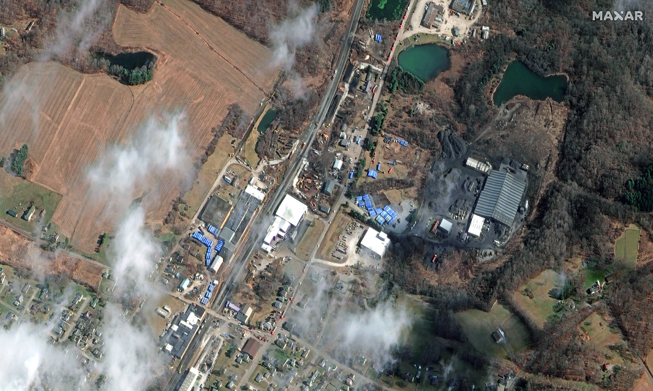
    Maxar Technologies shared via Twitter satellite imagery from the aftermath of the train derailment and explosion in East Palestine, Ohio. The train derailed on Feb. 3 and was carrying toxic materials.

    The satellite images show the ongoing cleanup efforts following the derailment. The wrecked train can be clearly seen as well as blue storage containers being used to collect hazardous materials.

    Hundreds of East Palestine residents had to evacuate their homes after a Norfolk Southern Railroad train carrying vinyl chloride derailed and exploded, emitting deadly fumes into the air and toxic material into the Ohio River.

    A Feb. 8 press release from Ohio Governor Mike Dewine stated that it was safe for residents to safely return to their homes. “There will be ongoing air monitoring in the area, but for those who would like air quality readings to be conducted within their homes, Norfolk Southern Railroad has hired an independent contractor to work with local law enforcement, the U.S. EPA, and state officials to take air quality samples and provide results at no charge to residents,” it said.

  • Quectel GNSS module wins Product of the Year

    Quectel GNSS module wins Product of the Year

    Quectel Wireless SolutionsLC76G GNSS module has been named a Product of the Year by Electronic Products. The annual awards recognize products that represent a significant advancement in technology or its application, an exceptionally innovative design, a substantial achievement in price/performance, improvements in design performance, and a potential for new product designs/opportunities. 

    Image: Quectel
    Image: Quectel

    The LC76G module is a compact, single-band, ultra-low power GNSS module that features fast and accurate location performance. The module can concurrently receive and process signals from all satellite constellations including GPS, GLONASS, BeiDou, Galileo and QZSS. 

    Image: Quectel
    Image: Quectel

    The LC76G has an internal surface acoustic wave (SAW) filter and integrated low-noise amplifier (LNA), which can be connected directly to a passive patch antenna and provides filtering against unwanted interference. With a compact size of 10.1 mm × 9.7 mm × 2.4 mm, the footprint of the LC76G is compatible with other industry solutions, as well as Quectel’s legacy L76 and L76-LB modules. 

    The LC67G is designed for battery-operated, ultra-low power GNSS devices, such as wearable personal trackers, wildlife and livestock tracking, toll tags, portable container trackers, as well as several traditional markets such as shared mobility and low-cost asset trackers. 

  • DroneShield partners with Pierce Aerospace for C-UAS tech

    DroneShield partners with Pierce Aerospace for C-UAS tech


    Image: DroneShield
    Image: DroneShield

    DroneShield and Pierce Aerospace have partnered to integrate Pierce Aerospace’s Flight Portal ID remote ID technologies into DroneShield’s counter-unmanned aerial system (C-UAS) and command and control systems (C2), which includes DroneSentry-C2. The integration will provide enhanced situational awareness to end users. 

    The inclusion of Flight Portal ID’s remote ID data feeds into DroneShield’s DroneSentry-C2 system enables end users to correlate and positively identify UAS. This enhances security operations and provides a holistic air picture with target discrimination. 

    Flight Portal ID remote ID technology consists of remote ID receivers, broadcast modules, software, integration capabilities and remote administration services. It has an integration service record with several commercial unmanned traffic management (UTM), detect and avoid, Department of Defense C2 and C-UAS systems.  

    “The integration of Flight Portal ID and DroneSentry-C2 provides users with the comprehensive picture needed to deconflict their airspace, maintain safe flight operations for both crewed and uncrewed aircrafts, while also having the real-time intelligence and means necessary to protect that airspace,” said Matt McCrann, CEO of DroneShield.  

    The combined technology has a wide range of end user applications, as UTM C-UAS solutions continue to merge for several user segments, across civilian government, military and private use cases. 

    The joint capabilities will be available to customers in 2023. 

  • EUSPA turns to CNES again for SAR-Galileo maintenance

    EUSPA turns to CNES again for SAR-Galileo maintenance

    The European Union Space Programme Agency (EUSPA) has signed a framework contract entrusting France’s space agency with providing Galileo search-and-rescue (SAR) services. The 137 million euro 10-year contract includes maintaining assets in operational condition, coordinating with the host sites and interfacing with the Cospas-Sarsat community.

    Image: EUSPA
    Image: EUSPA

    The National Centre for Space Studies (CNES) has been responsible for operations of SAR-Galileo services for the European Union since 2016, providing the SAR-Galileo Forward Link Service and the Return Link Service. The coordination of operations and maintenance of the ground segment, deployed across Europe, is headquartered at the space center in Toulouse, France.  

     A network of reference beacons enables evaluation of the performance of the systems in real-time. CNES also provides its expertise to EUSPA for the definition of international standards, performance monitoring and future developments.  

     Emergency position-indicating radio beacon-based services is an addition to the framework contract. CNES has already been identified as the future operator of the Emergency Warning Service, an alert service for European communities scheduled to begin operations in 2024.  

     The SAR-Galileo Return Link Service was declared operational on Jan. 21, 2020. 

  • GeoCue adds to its UAV/lidar imagery systems

    GeoCue adds to its UAV/lidar imagery systems

    GeoCue has released the TrueView 535 imaging system for UAVs, and the TrueView 720, its fourth-generation Riegl integration. It also launched its LP360 software add-on called 3D Accuracy and the Accuracy Star hardware.  

     TrueView 535 is built on TrueView 515’s technology and consists of updated lidar sensors, adding a third return, increasing mapping abilities below canopy. An additional third nadir camera offers another point-of-view and improves photogrammetry quality. It also includes a longer, usable lidar range to increase flexibility.  

    TrueView 535. (Image: GeoCue)
    TrueView 535. (Image: GeoCue)

    TrueView 720 is a fourth-generation Riegl VUX-120 with three laser beam orientations. It provides high point-density corridor mapping. Using the Riegl VUX-120 with three laser beam orientations (nadir, +10-degrees forward and –10-degrees backward) and three oblique/nadir cameras enables data collection from more surfaces in one flight path. 


    Trueview 720. (Image: GeoCue)
    Trueview 720. (Image: GeoCue)

    One application of TrueView 720 is scanning power lines. Users can capture the poles vertically, front and back. The extreme range of this system means it can be integrated with UAVs, airplanes or helicopters.  

     In addition to the two sensor payloads, GeoCue has launched its LP360 software add-on for processing and visualization — the 3D Accuracy and the Accuracy Star hardware. 

    Accuracy Star. (Image: GeoCue)
    Accuracy Star. (Image: GeoCue)

    “When used together, Accuracy Star and the 3D Accuracy add-on provide automated horizontal and vertical checks,” said Darrick Wagg, vice president of customer success for GeoCue. “You can automatically find a 3D target on a drone dataset. The software will calculate the correction for any 3D target and provide a seamless workflow to apply the correction on the point cloud.”

    These products are suitable for geospatial professionals.

  • Trimble introduces module for rail monitoring

    Trimble introduces module for rail monitoring

    Image: Geoff Eccles/ iStock / Getty Images Plus/Getty Images
    Image: Geoff Eccles/ iStock / Getty Images Plus/Getty Images

    Trimble has released Trimble 4D Control (T4D) version 6.4 software and an add-on monitoring module for automated and semi-automated rail monitoring. The T4D Rail module enables simple data collection and reduces office work required to automate movement detection for rail monitoring projects.  

     The T4D software offers four main elements for automated monitoring: sensor management and data integration for GNSS, total station, geotechnical, vibration and environmental sensors; geodetic processing and adjustments for accurate results; analysis and visualization through several tools that provide real-time updates to support in-depth analysis and data presentation; and alarming and reporting.  

     The T4D Rail module enables integration of rail as-builts collected with the Trimble GEDO system or with a track measuring bar paired with the Trimble Access Gauge Survey app. It can also automate calculations for track geometry parameters, generate analysis charts, and trigger alarms. 

     The T4D software is offered in five editions to fit various project requirements. The editions include T4D Access, T4D Field, T4D Intermediate, T4D Geotechnical and T4D Advanced. T4D Access and T4D Advanced are the two editions that support the add-on Rail Module.

    Image: Trimble
    Image: Trimble
  • GEODNET correction service designed for agriculture

    GEODNET correction service designed for agriculture


    Image: GEODNET
    Image: GEODNET

    GEODNET has released a real-time kinematic (RTK), centimeter-precision, GNSS corrections service designed for OEMs and system integrators of agricultural robotics. GEODNET is compatible with several GNSS receivers from major brands, on-vehicle automated steering, spraying kits, and most UAVs and robots.  

    The GEODNET corrections service has more than 1,700 total full-constellation reference stations worldwide and supports GPS, Galileo, GLONASS and BDS signals. It also has the RTCM 3.2 data format for maximum rover/receiver compatibility and NTRIP sign-on and access. 

     Additional local reference stations can be added.  

     Free GEODNET correction service trials are available now for qualified OEMs and system integrators in most agricultural regions globally. Interested parties can apply for a trial stream here 

  • Raytheon claims Navy contract to provide JPALS to Japan

    Raytheon claims Navy contract to provide JPALS to Japan


    Image: Raytheon Technologies video screenshot
    Image: Raytheon Technologies video screenshot

    Raytheon Intelligence and Space has been awarded a contract from the United States Navy’s Naval Air Traffic Management Systems Program Office to deliver the Joint Precision Approach and Landing Systems (JPALS) to the Japan Maritime Self-Defense Force (JMSDF). The GPS navigation and precision landing system will be deployed on the JMSDF JS Izumo carrier.  

    The JPALS system guides aircraft onto carriers and assault ships in all weather and surface conditions and is integrated on all F-35 aircraft. JPALS is also being deployed on all U.S. Navy aircraft and assault ships. 

    In addition, JPALS will be deployed on two international platforms, including the United Kingdom Royal Navy’s HMS Queen Elizabeth, and an Italian aircraft carrier, the ITS Cavour, to support its F-35 squadron. 

    The primary work locations for JPALS are in Largo, Florida and Fullerton, California.   

  • Walmart launches UAV for deliveries in Utah

    Walmart launches UAV for deliveries in Utah

    Image: Walmart
    Image: Walmart

    Two Walmart locations in Utah, one in Lindon and one in Herriman, are now providing UAV delivery for customers nearby. Walmart has UAV deliveries operated by DroneUp, Flytrex and Zipline at 36 stores in the United States.   

    For a $3.99 fee, customers within a mile of the stores can receive their groceries via UAVs. The two Walmart locations in Utah can deliver more than 120 times per day and each UAV can carry up to 10 pounds. The hubs for deliveries are in the parking lots of each Walmart location and are operated by Federal Aviation Administration-certified pilots. 

    Walmart is using UAV delivery in seven states, including Florida, Arizona, Texas, Utah, Virginia, North Carolina and Arkansas. The most common products delivered include ice cream, lemons, rotisserie chicken, Red Bull and paper towels, according to Walmart.   

    Walmart drone deliveries launched in October 2019 in Arkansas. In 2022, Walmart completed more than 6,000 deliveries across all 36 participating locations. 

  • Galileo signal component successfully tested for IoT use

    Galileo signal component successfully tested for IoT use

    One Galileo satellite has been reconfigured to emit a new signal component optimized to serve low-end receiver devices and internet of things (IoT) applications. According to the European Space Agency (ESA), GSAT0202, in elliptical orbit, was reconfigured in January to transmit the new signal, also known as the G1 E5 Quasi Pilot.

    The G1 E5 Quasi Pilot in the E5 band lies along a narrow part of the overall Galileo signal, intended to enable streamlined positioning fixes requiring less calculation — without affecting the E1 and E6 signal bands, on which Galileo also transmits. The initial receiver test showed that the signal component has the potential to reduce the signal acquisition time by a factor of three compared to the current GPS L5 or Galileo E5a signals.

    Image: ESA
    Image: ESA

    Once GSAT0202 was reconfigured, signal measurements were collected using the high-gain antenna installations from the Galileo in-orbit test facility, which confirmed the stability of the augmented signal. After G1 E5 Quasi Pilot was broadcast, it was successfully acquired and tracked by a set of receivers.

    Airbus Defense and Space, Thales Alenia Space Italy, the European Union Agency for the Space Programme (EUSPA), the European Commission, and Spaceopal supported this test.

    The other elliptical Galileo satellite, GSAT0201, will also be reconfigured after further testing. Selected chipset manufacturers will be involved in the testing under supervision of EUSPA. The test results will be evaluated at the Galileo Programme level, to eventually introduce G1 E5 Quasi Pilot into the constellation.

    Image: ESA
    Image: ESA
  • Hexagon releases platform for defense mobile apps

    Hexagon releases platform for defense mobile apps

    Image: Hexagon
    Image: Hexagon

    Hexagon’s Safety, Infrastructure & Geospatial division has released for Android defense applications. The platform is designed for the development of mobile applications for dismounted soldiers in the field. 

    With LuciadCPillar, developers can build applications with 2D and 3D views. It features military symbology and supports many geospatial data types including vector data, raster data, elevation data, point clouds and 3D meshes. It has the same capabilities found in desktops, in-vehicle and browser applications built with LuciadLightspeed, LuciadCPillar and LuciadRIA. 

    The platform offers capabilities to match high-resolution screens, graphic processing units and multi-core processors including the ability to display 3D data in mobile applications. LuciadCPillar supports ARM processors and an application programming interface, which aligns with the Android developer experience. 

    Impact, a French system integrator, partnered with Hexagon to test LuciadCPillar and will integrate it into its Delta Suite product, which is used by the French Special Operations Command.  

    LuciadCPillar is part of Luciad 2022.1, which is available now globally.  

  • Atmos enhances UAV with Sony cameras

    Atmos enhances UAV with Sony cameras

    Image: Atmos
    Image: Atmos


    Atmos has integrated the Sony a7R mark III and IV camera into its vertical take-off and landing (VTOL) fixed-wing UAV, the Marlyn CobaltThis will increase coverage and accuracy achieved in a single flight for surveyors.

    Both cameras have an ISO of 32,000, which is expandable to 102,400, and camera sensors with high megapixel count — 42,4 MP for the a7R III and 61 MP for the a7R IV. When combined with Zeiss’ 35 mm and 21 mm lenses, it enables UAV surveyors to achieve ground sample distance levels below one 1 cm.

    The integration of the two cameras enables Marlyn Cobalt users to map an area of 210 hectares with centimeter-level accuracy in a single flight.