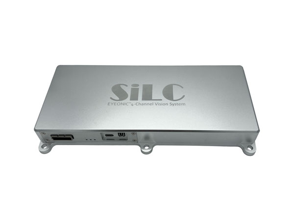
SiLC Technologies has launched the Eyeonic Vision System. This system is a frequency-modulated continuous wave lidar solution, which delivers high levels of vision perception to identify and avoid objects with low latency.
At the core of the Eyeonic Vision System is SiLC’s fully integrated silicon photonics chip. It provides more definition and precision than legacy lidar solutions, with roughly 10 milli-degree of angular resolution coupled with millimeter-level precision. These features enable this solution to measure the shape and distance of objects with high-precision and at a large distance.
The system combines the Eyeonic Vision Sensor and a digital processing solution based on a powerful field-programmable gate array. The flexible architecture enables synchronization of multiple vision sensors for unlimited points per second.
SiLC demonstrated the Eyeonic Vision System at CES 2023. It was named by the CES award committee as an honoree for the CES Innovation Award.
The compact, powerful, vision solution is suitable for autonomous vehicles, smart cameras, robotics and other advanced products. It is available now. Pricing varies depending on configuration.
Ness Czech will supply the Czech Railway Administration with a Digital Technical Railway Map (DTRM) with help from Hexagon’s Safety, Infrastructure and Geospatial division. The DTRM project has been underway since September 2022 and will be implemented by 2025.
DTRM is a railway-specific geographic information system (GIS), that provides access to transport and technical infrastructure information to better prepare investments and repair work. The basis of the DTRM project is the Technical Map Information System (ISTEM) developed by Ness and Hexagon.
The project includes digitization and consolidation of all available Czech Railway Administration data, covering more than 9,200 km of tracks, 27,000 km of technical infrastructure and an area of 21,000 ha. The delivery also includes three data centers.
The project is a legislative obligation of the Czech Railway Administration as the state is developing a national map, which will be fully operational by 2024. The Digital Technical Map of the Czech Republic is being built across the country by connecting regional digital maps, maps from the Railway Administration and maps provided by the Directorate of Roads and Highways. The connection is provided by the Czech Land Surveying and Cadastral Office.
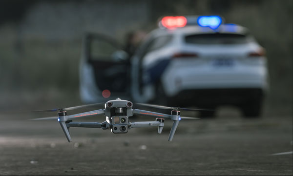
uAvionix has received approval by the Federal Aviation Administration (FAA) to conduct beyond-visual-line-of-sight (BVLOS) small unmanned aerial flight in North Dakota. The test flight to secure approval took place at the Northern Plains UAS Test Site in North Dakota.
Vantis is North Dakota’s UAS network, which serves many UAS operators across different sectors. By leveraging Vantis, uAvionix demonstrated to the FAA it had established adequate risk mitigations to satisfy required safety standards for BVLOS operation within the national airspace system.
The Northern Plains UAS Test Site partnered with Thales USA to develop and implement Vantis. The UAS system enables UAS pilots to command and control the UAS and remain clear of other aircraft when flying BVLOS. Vantis includes ground-based aviation infrastructure, which lowers the barrier of entry to BVLOS flights for multiple users.
The FAA approval to conduct BVLOS UAS flights is another step in bringing UAS to commercial sectors. UAvionix continues to collaborate with FAA as regulations evolve to ensure Vantis meets all necessary requirements.
Percepto has announced the U.S. Federal Aviation Administration (FAA) has approved the use of its UAV-in-a-box solution to perform highly automated beyond visual line of sight (HA BVLOS) inspections and monitoring operations at a large solar power plant in Texas.
The HA BVLOS UAV will fly at 200 feet above ground, which is double the altitude of any previously approved operation in the United States. The ability to fly at a higher altitude will enable greater operational flexibility to monitor large areas and tall structures in the future, including mapping and modeling.
Percepto’s HA BVLOS UAV enables an automated detect and avoid cycle, eliminating the need for remote pilot in command interventions if other aircraft are detected. Additionally, this capability negates the need for a pilot or visual observer on site.
The FAA approval for the solar plant deployment serves as a model for other industries including mining and oil and gas, to potentially increase site efficiency through automated remote inspection operation.
In December 2022, uAvionixannounced its updated product line for unmanned aerial systems (UAS) beyond visual line of sight (BVLOS) command and control (C2). The SkyLine C2 management platform and muLTElink airborne radio systems (ARS) are designed to integrate, which enables a self-healing C2 network capable of both path and link diversity. This eliminates lost-link possibilities over broad terrain and altitude ranges.
Image: uAvionixImage: uAvionix
MuLTElink ARS consists of two models — muLTElink915 and muLTElink5060, the core of the uAvionix C2 system. The muLTElink915 model combines globally licensed aviation LTE, enhanced with frequency hopping 902–928 MHz industrial, scientific and medical frequencies capability. The muLTElink5060 model combines global LTE with aviation-protected 5,030–5,091 MHz C-band for customers holding C-band licenses for control and non-payload communication (CNPC) operations.
Each muLTElink model allows up to one external CNPC radio to be optionally connected to allow simultaneous use of all three frequency ranges, higher power C-band operation or future radio integrations.
UAvionix updated its previous line of microLink and SkyLink ARS radios and relaunched them under the SkyLink ARS banner. Each SkyLink ARS can operate as a point-to-point radio or integrate with muLTElink and SkyLine for managed C2 operations. SkyLink915micro, formerly named microLink, offers a robust form factor and Lemo connector for UAS requiring hardened installations.
SkyLink5060micro and SkyLink5060 offer 100 mW and 10 W 5,030–5,091 MHz aviation protected C-band CNPC options.
Both platforms meet standards set by RTCA DO-362A and the U.S. Federal Aviation Administration’s draft Technical Standard Orders-C213a and may receive similar validated orders through other global aviation regulators.
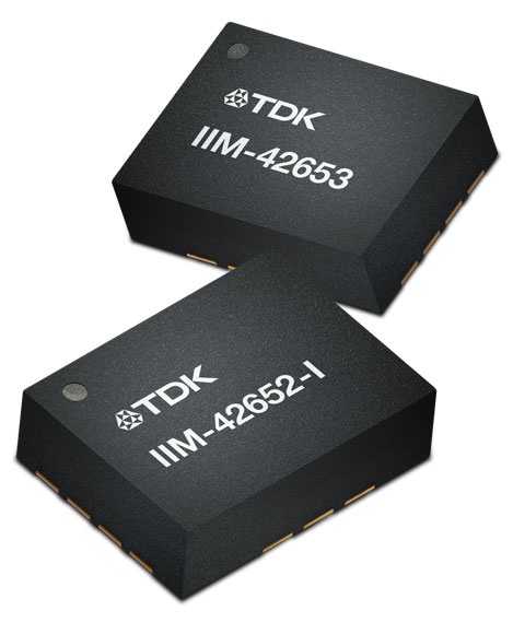
On Jan. 4, TDK Corporation announced the addition of the IIM-42653 and IIM-42652-I platforms to its InvenSense SmartIndustrial family of compact and low-power sensor platforms. IIM-42653 and IIM-42652-I consist of 6-axis IMUs, which target industrial and navigation applications requiring high force sensitive resistor (FSR) performance or inertial navigation software.
The IIM-42653 platform—a robust, low-noise, low-power, 6-axis IMU—is capable of a gyro-programmable output of 4,000 dps and an accelerometer-programmable output of 32 g. These features make IIM-42653 ideal for applications including industrial-grade or high-end automated guided vehicles, automated mobile robots and unmanned aerial vehicles.
The IIM-42652-I platform, a compact 6-axis IMU, offers hardware authentication and can be integrated with TRACK dead reckoning software from Trusted Positioning, a TDK Group company. The TRACK software, which is available for purchase through a licensing agreement, filters GNSS multi-path errors and provides a continuous navigation solution when GNSS signals are unavailable.
IIM-42653 is available now for select partners and customers only and will be available at TDK distribution partners in April. IIM-42652-I is available now at InvenSense-authorized distributors.
Autel Robotics has unveiled its EVO Max 4T UAV, an intelligent flight platform designed for enterprise and professional applications. The company made the announcement at CES 2023.
EVO Max 4T’s autonomous flight technology and artificial intelligence features give it self-reliance and navigation capabilities. It has omnidirectional obstacle avoidance and tri-anti-interference capability to ensure flight safety and stability in high-interference environments.
It is equipped with three high-quality cameras including a 48 MP telephoto camera, a 50 MP wide-angle camera and an infrared camera. The platform has a range of navigation and data-acquisition functions, including 3D flight routes, PinPoint Mode, Team Work, Polygon Mission, Waypoint Mission and Oblique Photography.
Autel Robotics also released the Dragonfish NEST and the EVO NEST. Dragonfish NEST is an automated electric vertical takeoff and landing (eVTOL) support system, with a range of up to 75 miles between units, and is suitable for long-range corridor inspections and large area coverage. EVO NEST is a base for automatic take-off, landing, charging and mission planning for EVO series UAVs. It is designed for all-weather operation and can be easily transported.
The Cybersecurity and Infrastructure Security Agency (CISA) at the Department of Homeland Security (DHS) recently released a three page “CISA Insights” document titled “Global Positioning System (GPS) Interference.” The January 2022 GPS jamming incident in Denver is discussed on the first page as an example of bad things that can happen and why GPS users should take precautions against interference.
Issued eleven months after the event, the report provides little new information, and leaves several important questions unanswered.
One of the most important questions is why it took so long to locate and end interference from a strong signal impacting such a large area.
The Federal Aviation Administration (FAA) was the first agency to become aware of the issue and the report credits the Enforcement Bureau of the Federal Communications Commission (FCC) with finding and terminating the spurious transmission.
Despite an “established national coordination process,” the interference was unabated for 33 hours.
While the report does not give details of the delay, likely reasons include the large number of agencies involved, diffuse authorities and responsibilities, the lack of a national interference detection system or a GPS/PNT “command center,” and several decades of funding and staffing reductions for FCC’s Enforcement Bureau.
How and why it happened
One of the primary reasons for doing an analysis of an accident like this is to prevent similar events in the future. Yet the CISA report provides no helpful information in this regard. It does not identify the source, nor the chain of events leading to the presumably accidental interference.
Those who might take steps to ensure that their operations don’t accidentally interfere with GPS signals learn nothing from the document.
A similar GPS jamming event occurred in October 2022 in the Dallas area. That one lasted 44 hours and the source was never identified. One wonders if this could have been prevented if the CISA report had been issued earlier and included more information.
Why the general public was not warned
The FAA issued a Notice to Airmen as soon as it became aware of the problem. The CISA report says surface (road and highway), rail, and telecommunications users were also impacted. Undoubtedly other types of users were also affected. Yet despite the outage lasting almost a day and a half, no public warning was issued to inform and protect non-aviation interests.
At a minimum, such a warning could have saved companies a lot of trouble and effort. A trouble report during the event from one public safety system operator provides an example of the unnecessary effort expended because a company did not know about the on-going disruption:
“Approximately 1530 on 21 DEC 22 two of our base transceiver systems began to lose sync. The GPS receivers, control cabling, and surge protectors were replaced with no change to loss of sync. There are no other BTS affected other than three sites in Aurora, Colorado … also problems with the local public safety P25 simulcast systems which have lost GPS lock in this area. Spok provides critical encrypted health care communications at these facilities.”
Warning the public could also help prevent more serious consequences, like the loss of life and property.
Troubling assertion
In this case, no losses of life or property have been connected to the disruption.
Yet the CISA report makes a more affirmative statement that “No accidents or injuries occurred because of the GPS interference incident.”
While we all certainly hope that was the case, and it may well be true, the CISA statement is troublingly certain.
A fairer and more accurate statement would be that “…none occurred, that we know of…” This would acknowledge that GPS is a safety of life system in many applications, and the seriousness of interference events.
Striving to do better
After its discussion of the Denver incident the report says improving GPS interference detection and mitigation is a CISA priority. And they are leading an interagency review to improve things.
This will be an uphill battle.
One challenge is DHS and other departments and agencies have limited authorities. The FCC is legally responsible for ensuring transmitters don’t trespass into unauthorized frequencies. However, its resources are limited and, as an independent agency not part of the administration, its participation in cross-governmental efforts is entirely voluntary.
Another is the lack of a clear, authoritative leader and champion for positioning, navigation, and timing (PNT) issues within the federal government.
Executive branch policy scatters PNT-related tasks thinly across the administration. These are to be coordinated by a senior level executive committee tasked to make recommendations “…to the President, through the Assistant to the President for National Security Affairs, or the Executive Secretary of the National Space Council…”
It is not hard to imagine that the details of PNT policy are rarely, if ever, brought to the attention of the President. This can lead to a stalemate between much more junior White House officials and greatly inhibit action.
Let’s hope the CISA report, limited as it is, highlights for leadership the many challenges faced by folks across government who care about GPS reception and national PNT issues. And that, as they collaborate on good solutions, they get the policy and budget support they deserve.
On Jan. 3, Hexagon and Dayou announced the availability of TerraStar-X Enterprise test beds in Beijing, Shanghai, Anqing and Shenzhen for OEMs in the automotive and micro-mobility industries. Terra-Star-X Enterprise precise-point positioning corrections provide lane-level accuracy with fast convergence for autonomous vehicles and mass-market use.
The availability of the test beds follows the initial announcement by Hexagon’s Autonomy & Positioning division and Dayou of their partnership aiming to deliver GNSS correction services to the Chinese market. Users of autonomous platforms will now have a single correction service that works in China, North America and Europe.
OEMs in China can now leverage the test beds with consumer and automotive-grade GNSS receivers to design advanced driver assistance systems (ADAS), and other products, such as mobile applications, safety-critical solutions and more.
On Jan. 5, DroneShield announced the completion of its Defense Innovation Hub project. This project resulted in improvements to its optical/thermal AI DroneOptID engine, as well as the development of a multi-sensor fusion artificial intelligence engine (SFAI).
DroneShield’s DroneOptID is AI powered and designed for autonomous optical detection, classification and tracking of UAVs. This engine can be integrated with command-and-control platforms, such as DroneShield’s DroneSentry-C2, which the new SFAI engine will become a core part this year.
The $800,000 project was first commissioned in November 2021 by the Australian Department of Defense, under phase two of the Defense Innovation Hub program. DroneShield was contracted to work on AI in multi-domain applications for the counter-unmanned aerial system space and more general military and government agency applications.
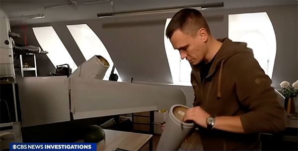
A Ukrainian intelligence assessment obtained by CNN and CBS reported an Iranian UAV downed in Ukraine contained technology from companies in the United States and other western countries. The White House has since launched an investigation as to how the technology — including semiconductors, GPS modules and engines — were obtained by Iran.
Screenshot: CBS video
The components removed from an Iranian Shahed-136 UAV totaled 52, 40 of which were manufactured by 13 different U.S. companies. The remaining components were manufactured by other western companies and companies based in Japan, Taiwan and China.The United States monitors exports and imposed restrictions and sanctions to prevent Iran from obtaining components for UAVs. Officials are now looking to enhance enforcement of the sanctions and are encouraging companies to monitor their supply chain, as well as identify third-party distributors who may be re-selling the technology to Iran.
U.S. companies are not alone in having to closely monitor their supply chains. U-blox, a Swiss semiconductor company, made a statement reinforcing its company policy, which bans the use of its technology in weapons. This was after u-blox GNSS modules were reportedly found in Russian UAVs.
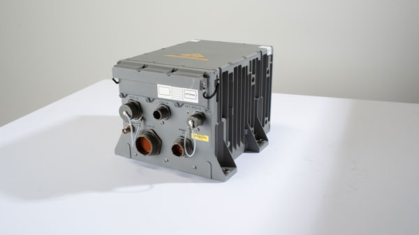
The Army tested the EGI units with enabled M-code on the MQ-1C Gray Eagle unmanned aerial system and validated it to be deployed on military aircraft. This year, the Army will begin migrating its fleet to the Honeywell EAGLE-M EGI with M-code, as this navigation solution enhances the resiliency of GPS navigation to enemy actions.
Image: Honeywell
The defense technology company has delivered more than 300 EGIs with M-code to customers and will deliver qualified units, featuring M-code GPS, to the Army. Honeywell is a leader in EGI for military applications and has provided more than 45,000 EGI units for several different types of aircraft in more than 30 countries.