Author: GPS World Staff

  • High Above Down Under: Database Offers 3D Elevation Model of the Globe

    High Above Down Under: Database Offers 3D Elevation Model of the Globe

    worlddem_aus_wipena-pound_2014-W
    (WorldDEM image courtesy of Airbus Space & Defence)

    Wilpena Pound, shown above, is a natural amphitheater of mountains in the heart of Flinders Ranges National Park in South Australia. Wilpena Pound is 17 kilometers long and 8 kilometers wide, covering an area of 100 kilometers. The highest peak is St. Mary Peak, at 1,170 meters.

    The WorldDEM Digital Elevation Model of the Pound is based on data acquired by the German high-resolution radar satellites TerraSAR-X and TanDEM-X, which started synchronous data acquisition in December 2010 and completed coverage of the Earth’s entire landmass twice over in mid-2013. The satellites covered more complex terrain areas with a third and fourth acquisition campaign to ensure accuracy for the WorldDEM mapping database, a 3D global pole-to-pole digital elevation model distributed by Airbus Defence and Space.

    Since its commercial launch in April 2014, WorldDEM has provided high-precision elevation models to a wide variety of industries. Mining studies in equatorial regions use it to analyze dense vegetation. It’s used for infrastructure corridor design and costing. Military and civil aviation use it for low-altitude flight path and landing-area planning for helicopters and aircraft in remote and difficult to access areas.

    The database now covers large parts of North and South America, Western and Southern Africa, the Middle East, Australia, Northern Europe and Asia. The most recent additions include complete coverage of Scandinavia, Ukraine, Iran, Iraq, Angola and Saudi Arabia. In all, 80 million km² of WorldDEM data has been captured.

    Check what areas are available.

  • The Business — October 2015

    The Business section from the October 2015 GPS World. Download the PDF.

    Includes:

    • INTERGEO’s Massive Marketplace
    • Antenova GNSS Antenna Integration
    • What Mattered Most at CTIA Super Mobility Week
    • UAV, Survey Markets Key for Maxtena Growth
    • Broadcom’s New Chip for Internet of Things
    • Autonomous Vehicles, Drones Next Big Thing for u-blox
    • PCTEST Expands Antenna Testing Capabilities with Rohde & Schwarz
    • Spirent Robust Framework Evaluates Threats to GNSS


  • Fourth Edition of GPS Satellite Surveying Book Published

    Fourth Edition of GPS Satellite Surveying Book Published

    Leick_GNSS_Survey_Book-WA new fourth edition of GPS Satellite and Surveying, by Leick, Rapoport and Tatarnikov, is available through NavtechGPS.

    GPS Satellite and Surveying is a comprehensive guide on GPS technology for surveying. Three prior editions have established it as a definitive industry reference.

    Updated and expanded to reflect the newest developments in the field, the fourth edition features cutting-edge information on GNSS antennas, precise point positioning, real-time relative positioning, lattice reduction and more. The authors — Alfred Leick, Lev Rapoport and Dmitry Tatarnikov — examine additional tools and applications, offering complete coverage of geodetic surveying using satellite technologies.

  • GPS III Launch Services RFP Released by Air Force

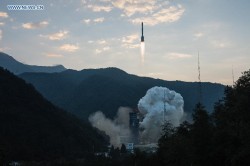
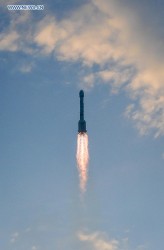
    The U.S. Air Force released a final Request for Proposal (RFP) for GPS III Launch Services on Sept. 30. Launch services include launch vehicle production, mission integration and launch operations for a GPS III mission scheduled to launch in 2018. Proposals are due back to the Air Force no later than Nov. 16 in accordance with the solicitation instructions.

    After evaluating proposals through a competitive, best-value source selection process, the Air Force will award a firm-fixed price contract that will provide the government with a total launch solution for the GPS III satellite. The Air Force’s acquisition strategy for this solicitation achieves a balance between mission success, meeting operational needs, lowering launch costs, and reintroducing competition for National Security Space missions, according to a statement by the Air Force.

    “Through this competitive solicitation for GPS III launch services, we hope to reintroduce competition in order to promote innovation and reduce cost to the taxpayer while maintaining our steadfast laser focus on mission assurance and assured access to space,” said Lt. Gen. Samuel Greaves, Space and Missile Systems Center commander and Air Force Program Executive Officer for Space.

    This will be a standalone contract for one GPS III launch, the Air Force said. This is the first of nine competitive launch services planned in the FY 2016 President’s Budget Request under the current Phase 1A procurement strategy, which covers awards with FY 2015-2017 funding. The next solicitation for launch services will be for a second GPS III mission.

    The Phase 1A procurement strategy reintroduces competition for national security space launch services. Under the previous Phase 1 strategy, United Launch Alliance (ULA) was the only certified launch provider. In 2013, ULA was awarded a sole-source contract for launch services as part of an Air Force “block buy” of 36 rocket cores that resulted in significant savings for the government through FY 2017.

    In May, Space Exploration Technologies (SpaceX) was certified for EELV launches resulting in two launch service providers that are qualified to design, produce, qualify and deliver a launch capability and provide the mission assurance support required to deliver national security space satellites to orbit.

    “With the recent certification of SpaceX, we now have multiple launch service providers that can service critical NSS missions. Reintroducing competition into EELV will ultimately save taxpayer dollars and increase assured access to space. ” said Claire Leon, director of SMC’s Launch Enterprise Directorate.

    “As part of this reintroduction of competition, we’ve been working with our industry partners to develop and finalize this RFP,” said Leon. “Their feedback has been critical to developing the criteria for this source selection and how we are innovating government processes to better match commercial processes as directed by OSD’s Better Buying Power 3.0. This is an exciting time in NSS launch acquisitions.”

    GPS III is the next generation of GPS satellites that will introduce new capabilities to meet the higher demands of both military and civilian users. GPS III is expected to provide improved anti-jamming capabilities as well as improved accuracy for precision navigation and timing. It will incorporate the common L1C signal which is compatible with the European Space Agency’s Galileo global navigation satellite system and compliment current services with the addition of new civil and military signals.

    The Air Force Space Command’s Space and Missile Systems Center, located at the Los Angeles Air Force Base, Calif., is the U.S. Air Force’s center of excellence for acquiring and developing military space systems.  Its portfolio includes the Global Positioning System, military satellite communications, defense meteorological satellites, space launch and range systems, satellite control networks, space based infrared systems and space situational awareness capabilities.

  • Tallysman Introduces High-Gain, High-Rejection Timing Antennas

    Tallysman Introduces High-Gain, High-Rejection Timing Antennas

    Photo: Tallysman Antenna maker Tallysman announces the availability of a family of high-gain (50 dB) and high-rejection timing antennas.

    The antennas are specifically designed for timing applications in high-density cell/telecommunications tower applications where high levels of near-out-of-band interfering signals can be expected. They feature a 50-dB LNA gain to handle long cable runs often associated with installation on telecommunications towers.

    The TW3150/52 antennas cover the GPS L1 and SBAS (WAAS, EGNOS and MSAS) frequency band and employ Tallysman’s unique Accutenna technology to provide excellent cross-polarization rejection and greatly enhanced multipath rejection.

    The TW3150 antenna features a four-stage dual-filtered LNA, while the TW3152 antenna includes an additional SAW pre-filter to provide exceptional rejection of close out-of-band signals and additional protection against saturation by high-level sub-harmonic and L-Band signals. This provides better than 80-dB of signal rejection above 1610 MHz and below 1545 MHz, Tallysman said.

    The antennas have a permanent mount, IP67 and MIL-STD-801F Section 509.4 compliant housing with metal base and an extended temperature range plastic radome, and is specifically designed to withstand the most challenging environmental conditions.

    Two options for mounting are available: an L-bracket (P/N#23-0040-0) or a pipe mount (P/N#23-0065-0).

    The new antennas are REACH and ROHS compliant.

  • Denver, FAA Partner on Drone Safety

    Denver International Airport and the Federal Aviation Administration (FAA) are partnering to raise awareness about safe unmanned aircraft operations.

    The agencies teamed up on a public service announcement that will run on the video towers in the airport’s main terminal. The PSA uses the “No Drone Zone” slogan to drive home the point that flying an unmanned aircraft near a manned aircraft is illegal and dangerous. It refers viewers to the FAA’s unmanned aircraft website and to the knowbeforeyoufly.org website for further information and guidance on flying unmanned aircraft safely and responsibly.

    The PSA will air all day today following its unveiling at an unmanned aircraft safety press event that the airport organized and hosted. After that, it will air for two weeks surrounding the winter holidays — a time when many people will be getting drones as gifts.

    Denver also will post the PSA on the airport website so it will reach travelers every day of the year.

    The FAA has partnered with leading unmanned aircraft industry and hobbyist groups in the Know Before You Fly education campaign, and the campaign materials are now featured in product packaging for several types of UAS.

  • CGSIC Meeting Report Provided by NAVCEN

    Rick Hamilton, CGSIC Executive Secretariat of the U.S. Coast Guard Navigation Center (NAVCEN) provided the following report on the Civil GPS Service Interface Committee (CGSIC) conference, which took place Sept. 14-15 in Tampa, Fla., before the Institute of Navigation’s ION GNSS+ conference.


    All CGSIC:

    On the 14th and 15th of September, the 55th meeting of the Civil GPS Service Interface Committee (CGSIC) conference was hosted by the U.S. Department of Transportation (DOT) and the U.S. Coast Guard Navigation Center (NAVCEN) at the Tampa Convention Center in Florida. DOT serves as the civil lead for GPS and chairs the CGSIC in this capacity. NAVCEN is assigned duties as Deputy Chair and Executive Secretariat for the CGSIC.

    On September 14, the Timing, States and Local Government, International Information, and Surveying, Mapping, and Geosciences subcommittees of the CGSIC held their meetings. A summary of their subcommittee meetings was presented to the CGSIC Plenary on September 15th.

    The Keynote speaker for this year’s CGSIC Plenary meeting was the Honorable Gregory Winfree, Assistant Secretary for Research and Technology, at the U.S. Department of Transportation. The agenda for the CGSIC Plenary meeting included presentations on the operational status and modernization of the GPS constellation of satellites, U.S. space-based PNT policy, GPS augmentation systems, and information related to international Global Navigation Satellite Systems.

    Several new briefings were part of the Plenary session this year, including presentations from the 19th Space Operations Squadron that provides GPS Launch, Anomaly and Disposal Operations (LADO), from NASA on space missions and their success in using GPS side lobes for space navigation beyond Geostationary orbit, and from Airservices Australia detailing progress in providing a Global Tracking capability in the wake of the missing Air Malaysia MH370 aircraft in the Indian Ocean. The Department of Homeland Security also provided an informative briefing that included discussion of use of Space-Based PNT in Critical Infrastructure and strategies for managing PNT risk.

    Many thanks to the 2015 CGSIC speakers for their excellent presentations which always make these meetings valuable and interesting, as well as great questions from the audience. This year, 220 attendees participated in the CGSIC meeting. All CGSIC presentations are available for viewing online via the GPS.gov website.

    Next year’s 56th CGSIC meeting will be held at the Portland Convention Center, 12-13 September 2016 in conjunction with the ION GNSS+ 2016 meeting in Portland, Oregon. Additionally, the CGSIC States and Local Government Subcommittee will meet on November 19, 2015, in conjunction with a Field Technology for Data Collection in Forestry, Fisheries, and Natural Resources Conference in Portland, Oregon. This meeting will be webcast and details will be circulated prior to the event to foster maximum participation from around the country. The CGSIC International Information Subcommittee will meet on November 16, 2015, in conjunction with the International Symposium on GNSS in Kyoto, Japan.

    As a reminder, CGSIC meetings are free and open to the public. Finally, GPS-related inquiries or reports of signal interference/degradation problems can be made to the U.S. Coast Guard Navigation Center or 703-313-5900.

    V/R
    Rick Hamilton
    CGSIC Executive Secretariat
    GPS Information Analysis Team Lead
    U.S. Coast Guard Navigation Center

  • China Launches 20th BeiDou Satellite with Hydrogen Clock

    Source: GPS world staff
    The 20th BeiDou satellite is launched, Sept. 30, 2015.

    China launched a new-generation BeiDou satellite into orbit at 7:13 a.m. China Standard Time on Wednesday, Sept. 30, according to the Xinhua News Agency, the 20th satellite for the BeiDou Navigation Satellite System.

    The satellite was launched from Xichang Satellite Launch Center in the southwestern province of Sichuan aboard a Long March-3B carrier rocket.

    In a first for BeiDou, the new BeiDou satellite is equipped with a hydrogen maser atomic clock. A series of tests related to the clock and a new navigation-signal system will be undertaken, according to the center as reported by Xinhua.

    China plans to expand the BeiDou services to most of the countries covered in its “Belt and Road” initiative by 2018, and offer global coverage by 2020.

    Named after the Chinese term for the plough or the Big Dipper constellation, the BeiDou project was formally launched in 1994. The first BeiDou satellite was launched in 2000.

    Two videos of the launch are available on the CCTV website.

    Video 1

    Video 2

  • Trimble’s TIMMS 2 Provides Maneuverable Indoor Mapping Solution

    Trimble’s TIMMS 2 Provides Maneuverable Indoor Mapping Solution

    Photo: TrimbleTrimble has introduced its next-generation Trimble Indoor Mobile Mapping Solution (TIMMS) that produces fast and accurate maps of difficult-to-navigate indoor spaces and translates them directly into 2D and 3D models of structured interiors.

    TIMMS 2 is a fusion of technologies for capturing spatial data of indoor and other GNSS denied areas, the company said. It provides both lidar and spherical video, enabling the creation of accurate, real-life representations of interior spaces and all of their contents. The maps are geo-located, meaning that the real world positions of each area of the building and its contents are known and can be easily placed and oriented in a wide area model.

    TIMMS 2 is smaller, lighter and more easily maneuverable than its predecessor. It can negotiate tight corners, closets and catwalks, and can be carried up and down staircases where no elevator is available for travel between building levels.

    “The new Trimble Indoor Mobile Mapping Solution has been designed with greater emphasis on ease of use. It is very easy to maneuver, lift, ship and operate,” said Louis Nastro, director of Land Products at Applanix, a Trimble Company. “Our extensive experience with a broad range of projects with the previous generation TIMMS has led to a number of enhancements in data collection, processing and workflow management — making an indoor mapping project a seamless experience for users both pre- and post-mission. Whatever the building type and shape, TIMMS 2 can deliver exceptional results, both in accuracy and ease-of-use.”

    Building on the success of the first-generation solution, TIMMS 2 also provides improved software workflow to manage the complete process from collection through post-processing to model production. Fully compatible with POSPac MMS, Applanix’ post-processing suite, TIMMS data can be presented in a variety of ways, including integration into Trimble Business Center and other infrastructure management or CAD packages.

    Because of its increased efficiency, speed and ease-of-use, TIMMS 2 is an effective and high-productivity indoor mapping solution for buildings and facilities of all shapes and sizes, according to Trimble, including large or small areas, multi-level, industrial or commercial spaces. Users can obtain holistic 3D indoor geospatial views of all kinds of infrastructure including public buildings (government offices, schools, hospitals); industrial facilities (factories, warehouses); transportation hubs (airports, train stations); retail spaces (malls, concourses); entertainment venues (theatres, auditoriums, sound stages); and residential property (especially multi-occupancy high-rise buildings).

    Maps and models of these spaces can be used for activities including revenue management and space planning; emergency preparedness and disaster planning; and historical building conservation and preservation. In addition, the base map provides a platform on which building owners and managers can serve location-based services.

    Manufactured and sold by Applanix, TIMMS 2 indoor mobile mapping solution is available in the first quarter of 2016.

  • Fleet Management Company Omnitracs Unveils New Brand Identity

    Fleet Management Company Omnitracs Unveils New Brand Identity

    Omnitracs-logoFleet management company Omnitracs LLC introduced today its new branding, which unifies its specialized business units under a single naming, messaging and creative architecture. Elements of the new brand platform include a redesign of the corporate logo and tagline, a refined core messaging, and new design treatments, the company said in a press release, all of which will be applied to the full spectrum of Omnitracs communications vehicles in the coming months.

    What operated before as independent business units — Roadnet, XRS, Sylectus and Analytics — are now fully integrated flagship products within Omnitracs’ broad range of solutions: compliance, safety and security, productivity, telematics and tracking, transportation management system (TMS), planning and delivery, data and analytics, and professional services.

    “Over the past few years and through a series of strategic acquisitions, Omnitracs has grown to become a global force in comprehensive fleet management solutions for fleets of all sizes, whether private or for-hire,” said Omnitracs CEO John Graham. “The new brand platform — from creative to messaging — properly aligns our distinct business units under the power of a single, well-respected brand: Omnitracs. The new branding is representative of the collective strength of our uniquely varied expertise, our continuous innovation and drive to revolutionize the transportation industry, and our ability to deliver best-in-class solutions to our customers for today and tomorrow.”

    A cornerstone of Omnitracs’ new brand is its signature, comprising the logo and tagline. The modern symbol that accompanies the Omnitracs logotype illustrates motion, innovation and convergence. The tagline, “innovation. driven.” speaks to the core attributes of the company and reflects both its inventive nature and focus on delivering the most reliable and valuable solutions available, the company said.

    “Omnitracs has long been recognized as the pioneer in fleet management solutions and as a product and technology innovator,” said Jim Gardner, vice president of marketing at Omnitracs. “Our new unified branding reflects the alignment of our business units into a single, end-to-end solution portfolio offering our customers greater insight into their business and higher profits from their fleets.”

    Omnitracs will further unveil its new visual branding, colors and imagery at the American Trucking Associations (ATA) Management Conference & Exhibition, Oct. 17-20 in Philadelphia.

  • INTERGEO Product Showcase

    GNSS Receiver for Mobile Devices

    The R2 GNSS receiver works with Trimble handheld devices and iOS, Android or Window mobile handhelds, smartphones and tablets using Bluetooth or USB connectivity. When paired with a mobile device, the receiver adds professional-grade GNSS capabilities for better accuracy. The rugged Trimble R2 provides GIS and survey professionals the flexibility to choose the mobile device, workflows and accuracy they need based on applications.

    The Trimble R2 GNSS receiver is compact and portable, weighing 2.4 pounds. With one button operation and field swappable battery, the receiver can be pole or vehicle mounted or carried on a backpack. The R2 is a multi-constellation receiver that supports GPS, GLONASS, Galileo, BeiDou and QZSS satellite signals as well as SBAS.The Trimble R2 can achieve sub-meter to centimeter positioning.

    Trimble, www.trimble.com

    Source: GPS world staff
    The Optech CZMIL Nova airborne bathymetric mapping system.

    Coastal and Marine Mapping

    The Optech CZMIL Nova airborne bathymetric mapping system is designed for coastal and marine mapping.With a powerful yet efficient laser, it maps deeper while flying higher, reaching depths of 80 meters in clear waters. The enhanced design and automated processing tools produce simultaneous high-resolution 3D data and imagery of the beach and shallow water seafloor, including coastal topography, bathymetry, benthic classification and water column characterization. Its bathymetric lidar is integrated with a hyperspectral imaging system and digital metric camera. Optech HydroFusion, an end-to-end software suite, handles data from all three sensors.

    Teledyne Optech, www.teledyneoptech.com

    Source: GPS world staff
    Leica Viva GS14.

    GNSS with Hybrid Communication

    The latest generation Leica Viva GS14 GNSS receiver now supports Verizon CDMA solutions along with all standard 2G/3G networks and UHF TX/RX radio in a single device, making it a professional GNSS receiver with all three communication systems built in. Users simply slide in their SIM card to experience instant connectivity for faster and easier field communications and SmartNet RTK corrections. No external equipment is required.

    Leica Geosystems, www.leica-geosystems.com

    Source: GPS world staff
    Tallysman’s VeraPhase 6000 high-precision GNSS antenna.

    High-Precision GNSS Antenna

    The VeraPhase 6000 family of antennas provides the lowest axial ratios (horizon to horizon, through all azimuths) across all GNSS frequencies (70 percent), a tight PCV (± 1mm through all frequencies, azimuths, and elevations), and a consistent PCO through all frequencies.

    The performance of the VeraPhase rivals that of choke ring antennas, but is much lighter, smaller and more economical. The antenna family is designed for use in survey, precision RTK and reference antenna applications.

    The VeraPhase 6000 also provides an available PCB within the base of the antenna for integration of a custom system board such as a dual-band or RTK GNSS receivers or other applications.

    Tallysman, www.tallysman.com

    Source: GPS world staff
    The GIS 2go Cadenza software suite.

    GIS Software Suite

    The GIS 2go Cadenza software suite for mobile GIS visualizes geodata and attribute data for efficient result presentation. This version offers new features for tablet or smartphone, allowing users to transfer maps from Cadenza or ArcGIS for Desktop to mobile devices for use offline and availability to others via the cloud, creating an extended field workstation. The mobile app also features faster exporting and optimized use of land registers for geometry and attribute editing in the field.

    Disy Informationssysteme GmbH, www.gis2go.com

  • Sensor Fusion by STMicroelectronics Enables 3D Navigation for Drivers


    STMicroelectronics is bringing next-generation satellite navigation to today’s drivers with the launch of enhanced, always-available, always-accurate 3D positioning on its TESEO III automotive-navigation integrated circuits (ICs).

    The new TESEO DRAW firmware for ST’s multi-constellation positioning chips enables navigation devices to provide continuous, accurate location and turn-by-turn instructions even when satellite signals are poor or unavailable, such as in tunnels, covered car parks, or multi-level highways. TESEO DRAW also enhances performance in built-up areas, such as in urban canyons, where conventional navigation systems can lose accuracy.

    TESEO DRAW merges the satellite information with data from vehicle sensors such as the gyroscope, accelerometer and wheel-speed sensors, to calculate location accurately in three dimensions including elevation. If the satellite signal is poor, TESEO DRAW compensates for the loss of accuracy, and if the signal becomes unavailable, navigation continues uninterrupted based on calculated location (dead reckoning). Road tests carried out by ST in difficult under-cover and urban environments have demonstrated continuous tracking from entry to exit in complex multi-level car parks, and at street level between tall buildings, where conventional systems have been unable to track the vehicle.

    By enabling high-accuracy 3D dead reckoning, TESEO DRAW expands the opportunities for developers to commercialize new applications, the company said.


    “TESEO DRAW strengthens GNSS performance and eliminates barriers to continuity, enabling exciting new services to emerge,” said Fabio Marchiò, Microcontroller and Infotainment Division general manager, Automotive Product Group, STMicroelectronics. “Users can also experience significant improvements in existing services such as fleet tracking, eCall, or ERA-GLONASS emergency response, usage-based insurance, road tolling, and anti-theft systems.”

    TESEO DRAW firmware has multiple modes and is capable of referring to sensors on the vehicle’s CAN bus or discrete sensors such as the odometer, reverse sensor, MEMS accelerometer and gyroscope, or MEMS inertial module connected to the TESEO III IC.

    ST is a supplier of MEMS motion sensors for automotive navigation, telematics and vehicle alarm systems, and is a provider of navigation engines with its TESEO IC family. With the launch of TESEO DRAW firmware, ST is able to provide a unified platform comprising navigation engines, 3D positioning capability and motion sensors.

    TESEO III ICs loaded with the new TESEO DRAW firmware are sampling now, and will enter mass production in Q1 2016.