Author: GPS World Staff

  • GPS Network Shows Drought in the U.S. West

    GPS Network Shows Drought in the U.S. West

    A GPS station in the Inyo Mountains, Calif. Credit: Shawn Lawrence, UNAVCO.
    A GPS station in the Inyo Mountains, Calif. Credit: Shawn Lawrence, UNAVCO.

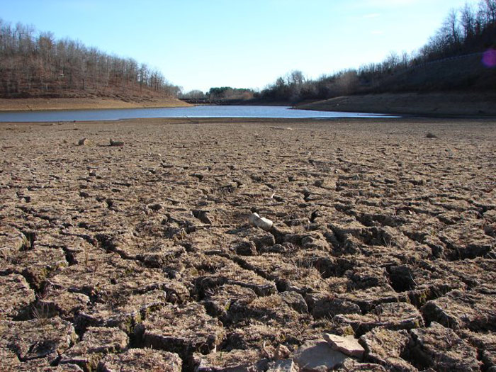
    A network of GPS stations in the western United States is revealing the severity of the drought in that region.

    Compared to the nine years before the drought, the GPS data show that the western United States has lost 240 gigatons of water, which is enough to flood the entire region in 10 centimeters of water.

    Investigating ground positioning data from GPS stations throughout the west, researchers at the Scripps Institution of Oceanography at the University of California, San Diego, found that the water shortage is causing an uplift effect up to 15 millimeters (more than half an inch) in California’s mountains and on average four millimeters (0.15 of an inch) across the west.

    Results of the study, which was supported by the U.S. Geological Survey (USGS), appear in the August 21 online edition of the journal Science.

    The measurements have a much better resolution — 200-300 kilometers — than data provided by NASA’s GRACE satellites, which shows how the water mass has changed on and below the Earth’s surface.

    California_Drought_Dry_Riverbed_2009
    A dry riverbed in California.

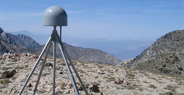
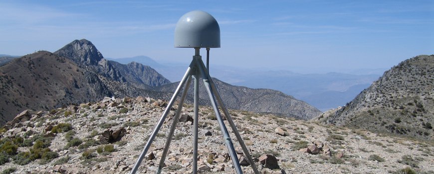
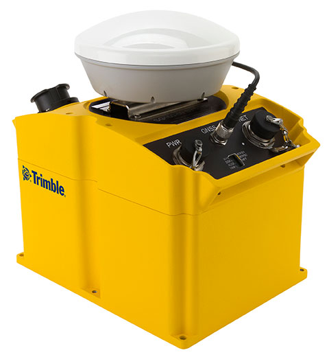
    Researchers Adrian Borsa, Duncan Agnew, and Dan Cayan used data from more than 700 GPS stations in the National Science Foundation’s Plate Boundary Observatory to measure the rising and falling of Earth’s surface due to the presence of water. Water in lakes or aquifers weighs down on the Earth causing the surface to sink, while during a drought the surface rises. Each station provides time and position information that is used to calculate the station’s location to within 1-2 millimeters horizontally and 3-5 millimeters vertically.

    The current drought began in 2012, when data shows that in general, the ground rose by about four millimeters. The rise in the Sierra Nevada mountain range was 15 millimeters.

    While poring through various sets of data of ground positions from highly precise GPS stations within the National Science Foundation’s Plate Boundary Observatory and other networks, Borsa, a Scripps assistant research geophysicist, kept noticing the same pattern over the 2003-2014 period: All of the stations moved upwards in the most recent years, coinciding with the timing of the current drought.

    Agnew, a Scripps Oceanography geophysics professor who specializes in studying earthquakes and their impact on shaping the earth’s crust, says the GPS data can only be explained by rapid uplift of the tectonic plate upon which the western U.S. rests (Agnew cautions that the uplift has virtually no effect on the San Andreas fault and therefore does not increase the risk of earthquakes).

    For Cayan, a research meteorologist with Scripps and USGS, the results paint a new picture of the dire hydrological state of the west.

    “These results quantify the amount of water mass lost in the past few years,” Cayan said. “It also represents a powerful new way to track water resources over a very large landscape. We can home in on the Sierra Nevada mountains and critical California snowpack. These results demonstrate that this technique can be used to study changes in fresh water stocks in other regions around the world, if they have a network of GPS sensors.”

    The study was supported by USGS National Earthquake Hazards Reduction Program.

  • deCarta Powers POI Search for Major Mobile Handset Maker

    Advanced Search Engine Replaces Google Local Search in 122 Countries

    deCarta, Inc., an independent LBS platform company, is now providing the local search function for a worldwide, top-five mobile handset manufacturer. deCarta has been hosting and running the search service since August 7 using its advanced geosearch engine — L2 — and has replaced the search service previously provided by Google. The service delivers millions of responses per day to this handset manufacturer’s local search and mapping application to users in 122 countries.

    deCarta’s L2 is a high-performance, scalable local search engine with single line input and intuitive user interface. deCarta sources and indexes map and POI (points of interest) content from a wide variety of sources globally but also enables customers to easily index, control and search on their own content. The customer service announced utilizes TomTom map and POI content.

    deCarta’s L2 can be used as a pure geocoder for address search, or for POI search, or simultaneously as a combination of the two mixed in a single-line search query — with the additional ability to tune this behavior at runtime. This gives developers maximum flexibility and creativity in producing their applications. deCarta recently expanded country coverage to enable its customers to offer global services.

    The L2 Search engine is an integral component of deCarta’s LBS platform which provides specialized geospatial technologies for maps, routing, navigation, geocoding, local search and geo-data integration and processing. deCarta provides its white-label LBS platform to companies that wish to offer their own customized, branded LBS services as opposed to utilizing industry standard services such as Bing or Google.

    deCarta has two deployment options for its platform: a hosted LBS Platform Service (PaaS) or, alternatively, customers can self-host either on-premise or in a cloud service such as Amazon’s AWS.  Both approaches utilize deCarta’s REST API architecture and can scale to support billions of maps and searches and millions of users per month.

    “We are quite happy with the market reaction to L2 since its introduction last year,” said J. Kim Fennell, CEO of deCarta. “We’re seeing large mobile, telematics and automotive customers switch to L2 in competition against other local search engines and geocoders such as Google, Bing, Nokia/Here and Pitney Bowes. Customers appreciate L2’s technology advantages, customization capabilities, flexible content offerings, less restrictive license terms and our superior customer service — all of which creates a more satisfied end customer experience.”

    L2 enables deCarta’s customers to offer flexible, advanced local search capabilities that are on par with Google Maps but beyond other search engines. Examples include:

    • Single line entry of POI or address or both
    • Fast typeahead, predictive entry – ideal for mobile devices
    • High tolerance for misspellings and partial entries
    • Random ordering of address parameters
    • Search for a POI near a POI such as “ATMs near AMC Theater” or “Parking near SFO”
    • Search for POI near a specific address, i.e. “Parking near 1234 Main Street”

    Furthermore, L2 can be integrated with deCarta’s patented “Search Along A Route” technology. This combined with the ability to index custom content and boost result rankings gives automotive OEMs and service providers the ability to offer more advanced and helpful “driver-centric” connected car services.

    For more information visit www.decarta.com or go to the demo at http://labs.decarta.com. Developers can find technical details at http://developer.decarta.com.

  • Agenda, Speakers Announced for Connected Fleets USA

    Telematics Update has announced the agenda and speaker line-up for Connected Fleets USA 2014, formerly known as Telematics for Fleet Management USA. The conference and exhibition will take place November 20-21 in Atlanta, Georgia. The early registration discount ends September 26.

    As growth is seen in goods movement and driver shortages, integration of the connected fleet in the supply chain, service bays, and transport infrastructure is crucial to maintain growth in the U.S. and abroad. Experts anticipate that there will be more investment, mergers and acquisitions, and consolidation in a rush to deliver the best-in-class solution to drive fleet optimization.

    The speakers just announced to take the stage at Connected Fleets USA will be reflecting this change. They include some of the largest fleet rental/leaser, OEMs and companies from across the value chain such as Donlen, Hertz Equipment Rental, ARI, Ryder, Daimler, John Deere, Microsoft, Los Angeles County Metropolitan Transportation Authority and up-and-coming start-ups like Peloton Technology and Metro Tech, Inc.

    Connected Fleets USA 2014 will look into ways to capitalize on the integration of solutions in the supply and create solid partnership models that will increase profitability and drive the connected fleets in the mature North American market

    “It will be critical that companies evaluate the opportunity present from the integration of connected fleets into the wider enterprise and embrace key breakthroughs in the wider connected ecosystem to create an indispensable connected vehicle service package to add value to fleet operators and carriers,” Daniel Pavey, Connected Fleets USA 2014 project director, said.

    Topics and Trends

    The trends and topics to be discussed include:

    • Connectivity is the future of transportation. Explore case studies and the roadmap for autonomous vehicles and V2V/V2I technology that can be leveraged to improve transport infrastructure, mobility, goods movement and traditional fleet manager needs.
    • Enterprise and telematics converge. Integrate vehicle and telematics data to the wider connected ecosystem,  including enterprise resource planning, work order management and maintenance bays to map opportunities where connectivity can ease bottlenecks in the supply chain.
    • Complete the leasing puzzle. Overcome the complexities of fleet leasing by integrating back-end analytics from embedded and aftermarket solutions for a seamless approach for improved driver performance and vehicle life-cycle to engage government, small local and large long-haul fleets.
    • The law of connectivity. Review current and potential proposals for data logging and vehicle-to-vehicle communication to assess legal opportunities and challenges for automated and connected vehicle technologies including liability, litigation and privacy to anticipate potential roadblocks.
    • The investment drive. Investigate the motivation and strategies of private equity, industry players, and government investment, including improving congestion and road safety, widening portfolios and entering new markets to position solutions for investment.
    • Smarter services through data sharing and analytics. Crack open the OEM platform to create a sandbox of data that combine vehicle, driver and environmental data to offer a more precise service portfolio.

    Other sessions will be held on topics such as integration with the advanced connected transport project; commercial data ecosystem, platform and partnerships; and exclusive case studies and panel discussions from Donlen, Hertz Equipment Rental, ARI, Daimler, John Deere and Volvo.

    For the complete Connected Fleets USA 2014 conference program and speaker line-up, visit the conference website.

    Newly Announced Speaker Line-up

    The connected fleet specialists set to speak this year include:

    • Nick Ehrhart, Vice President Business Development, Donlen
    • Mike Dennis, Group Director Maintenance Operation, Ryder Systems, Inc.
    • Casey J Littleton, HERC Global Product Manager – Telematics, Hertz Equipment Rental
    • Shawn Meredith, Manager, Strategy & Product Management, Daimler Trucks North America
    • Conal Deedy, Director, Connected Vehicle Services, Volvo Trucks
    • Edward Olson, Program Manager, Telematics, John Deere Power Systems
    • Ernesto Chaves, Transportation Planning Manager, Los Angeles County Metropolitan Transportation Authority
    • Peter Vanderminden, Industry Manager, Manufacturing & Supply Chain, Microsoft
    • Mohammad Poorsartep, Research Scientist, Texas A&M Transportation Research Institute
    • Joshua Switkes, Founder and CEO, Peloton Technology Inc.
    • Christian Kotscher, CEO, MetroTech Net Inc.
    • Clem Driscoll, President, C.J Driscoll & Associates
    • Scott Mattson, Director, William Blair & Co

    and many other specialists from across the value chain. The full speaker line-up is available on the website.

    For the complete Connected Fleets USA 2014 conference program and speaker line-up, access the e-brochure or contact the Telematics Update team at [email protected]. Register before September 26 to take advantage of a $300 saving on all conference passes.


  • Majority Support FCC Rule Requiring Carriers to Provide Accurate Indoor Locations

    A new survey of more than 1,000 consumers found a dramatic gap between the limited location requirements for cell-phone carriers and broad public expectations that wireless callers can be found by emergency responders if they dial 9-1-1 in an emergency.

    According to the survey, two-thirds of cell-phone owners (66 percent) thought that wireless companies could help emergency responders locate them at least to their block, if they call 9-1-1 from inside their homes. Only 6 percent of cell-phone owners correctly responded that the information would likely only be accurate to the neighborhood level or worse.

    When told that current FCC regulations do not require cell-phone carriers to provide an accurate location for callers inside buildings, 83 percent said it was very or critically important to public safety for the FCC to adopt a rule to require cell-phone companies to generate that information. Reinforcing those findings, 79 percent said the FCC should begin enforcing the rule within two years, with nearly half (46 percent) saying the FCC should begin enforcement immediately.

    “When people dial 9-1-1 on their cell phones, they think the operator can find their location to send help,” said Jamie Barnett, director of the Find Me 911 Coalition and former chief of the FCC’s Public Safety and Homeland Security Bureau. “Unfortunately, the carriers have chosen cheaper, less-effective location technologies, and people are dying because emergency responders can’t find them. If you call 9-1-1 on your cell phone inside or in an urban canyon, the carriers’ technologies will often fail to accurately locate that call. Happily, technologies exist now that can find callers indoors and save lives. The carriers’ responsibilities should match consumer expectations that they can be found when they dial 9-1-1 from indoors.”

    Survey respondents also said that they would be willing to vote with their wallets, with nearly two-thirds (63 percent) saying they would consider switching cell-phone companies to a provider who could more accurately and reliably find 9-1-1 callers.

    Among the survey’s findings:

    • Most think all wireless 9-1-1 calls can be found. By a 7-1 margin, respondents thought that emergency responders could find their cell phone’s location if they dialed 911 in an emergency (59.0 percent to 8.5 percent).
    • Indoor callers think 9-1-1 locations are accurate to the block or house level.  Two-thirds of respondents (66 percent) said that cell-phone companies would share location information accurate at least to their block, and 55 percent believed it would be accurate at least to their house if they called 9-1-1 while at home.
    • Cell phones are the most common way to reach 9-1-1. Of respondents who have dialed 911, 57 percent most recently used a cell phone, not a traditional land line.
    • Half of 9-1-1 calls come from indoors or urban canyons. On their last 911 call from a cell phone, half of the respondents were inside a physical building (42 percent) or in an urban canyon (8 percent), where GPS technology is not reliable.
    • Most deeply concerned over lack of indoor location requirements. More than two-thirds of respondents (69 percent) said they would be extremely or very concerned if they learned that cell-phone companies were not required to provide an accurate indoor location to emergency responders.
    • Proposed FCC rule is vital to public safety. A large majority (83 percent) said the proposed rule is critically or very important to public safety in their communities.
    • FCC should implement requirements of rule within two years. Four-fifths (79 percent) said the FCC should begin enforcing the rule within two years, with nearly half (46 percent) saying the FCC should begin enforcement immediately.
    • Most oppose any delay in indoor location requirements. A large majority (71 percent) oppose any delay in implementation of the FCC’s rule.
    • Consumers willing to switch companies for better 9-1-1 accuracy.  Nearly two-thirds (63 percent) would consider switching their cell provider to a company with a more accurate system for 911 callers, with one in three (30 percent) saying they would definitely or probably do so.

    According to FCC estimates, at least 10,000 lives a year could be saved by improvements in response time through the FCC’s proposed rule.

    The survey was conducted online among 1,048 adult cell-phone owners in the US from August 15-18, 2014.  The survey was conducted via SurveyMonkey.com using a custom audience sample selected from the site’s 30 million users.  The survey had a margin of error of +/- 3 percent at a 95 percent confidence level.

    Find Me 911 is an effort supported by more than 200,000 individuals, as well as national and local organizations. The individuals and organizations represent a broad range of 911 operators and first responders — emergency medical services personnel, fire fighters and police.  Find Me 911 seeks to ensure that the Federal Communications Commission (FCC) move forward quickly to establish a reasonable, measurable level of location accuracy for emergency calls made indoors, enabling first responders to locate emergency calls from wireless phones from all locations rapidly and efficiently.

  • Canadian Science Minister Announces Grant to Langley’s UNB Lab

    Canadian Science Minister Announces Grant to Langley’s UNB Lab

    Professor Langley (center) discusses the UNB geodesy program with Canadian Science Minister Ed Holder (second from left.)
    Professor Langley (fourth from left) discusses the UNB geodesy program with Canadian Science Minister Ed Holder (third from left.)

    The Canadian Minister of State for science and technology, Ed Holder, visited the University of New Brunswick on July 28 to announce the awarding by the Natural Sciences and Engineering Council of $2.4 million to 28 UNB researchers.

    He was joined by Keith Ashfield, member of Parliament for Fredericton, where UNB is based, and Craig Leonard, the New Brunswick Minister of Energy and Mines.

    A highlight of the visit was a tour of the Department of Geodesy and Geomatics Engineering to see the work of Prof. Richard Langley and his students. Langley received $170,000 in Natural Sciences and Engineering Research Council (NSERC) funding in the competition. The funding will support the work of his group in improving augmented multi-constellation satellite-based precise positioning in a wide range of environments. Langley is GPS World’s Innovation editor, a post he has held since the magazine’s inception.

    Canadian Science Minister Ed Holder looks at GPS World magazine, which has featured Innovation columns edited by Richard Langley for more than two decades.
    Canadian Science Minister Ed Holder looks at GPS World magazine, which has featured Innovation columns edited by Richard Langley for more than two decades.

    Although GPS was the first widely available satellite navigation system, it has now been joined by the Russian GLONASS system, and will soon be accompanied by the European Galileo system, the Chinese BeiDou system, and the Japanese QZSS — all of which have test satellites now in orbit. There are interesting problems to be solved in gaining maximum benefits from this plethora of GNSS for precise positioning and navigation, and Langley and his team will address a number of them.

    The team is also involved in the analysis of data from the GPS-based instrument on the Canadian CASSIOPE scientific satellite launched at the end of September 2013. The instrument, which precisely determines the position of the satellite and provides information on the state of the Earth’s ionosphere, was designed at UNB.

    The NSERC Discovery Grants Program is an integral component of the government’s efforts to develop, attract and retain the world’s most talented researchers at Canadian universities. The program funds discovery research in a multitude of scientific and engineering disciplines, which builds a broad base of research capacity across the country.

    Professor Langley gave the following presentation at the NSERC Discovery Grants Scholarships Rollout Announcement at UNB on July 28:

  • Trimble Offers GNSS Reference Receiver, Seismic Recorder

    Trimble Offers GNSS Reference Receiver, Seismic Recorder

    The Trimble SG160-09 SeismoGeodetic system.
    The Trimble SG160-09 SeismoGeodetic system.

    Trimble has introduced an integrated GNSS reference receiver, broadband seismic recorder and a force-balance triaxial accelerometer for infrastructure and precise scientific applications.

    The Trimble SG160-09 SeismoGeodetic system provides real-time GNSS positioning and seismic data for earthquake early warning and volcano monitoring as well as infrastructure monitoring for buildings, bridges, dams, as well as other natural and manmade structures.

    The announcement was made at the Second European Conference on Earthquake Engineering and Seismology (2ECEES) in Istanbul, Turkey.

    The Trimble SG160-09 SeismoGeodetic system combines the innovation, reliability and data integrity of both the Trimble and REF TEK brands into a single instrument, Trimble said. The system integrates seismic recording with GNSS geodetic measurement in a single compact, ruggedized package. It includes a low-power, 220-channel GNSS receiver powered by the latest Trimble-precise Maxwell 6 technology and supports tracking of both GPS and GLONASS signals plus the Galileo E1 frequency.

    The system includes both the SG160-09 and utilization of Trimble’s CenterPoint RTX correction service, which provides on-board GNSS point positioning. Based on Trimble RTX technology, the service utilizes satellite clock and orbit information delivered over cellular networks or Internet Protocol (IP), allowing cm-level position displacement tracking in real-time anywhere in the world. The SG160-09 system will be available for purchase without the RTX correction service for those applications using real-time kinematic (RTK) positioning.

    The seismic recording sensor includes an ANSS Class A, low-noise, force-balance triaxial accelerometer with the latest, low-power, 24-bit A/D converter, which produces high-resolution seismic data. The internally built accelerometer has +/- 4g full scale output, large linear range, high resolution and sensitivity, which makes it ideal for both portable and permanent deployment. The SG160-09 processor acquires and packetizes both seismic and geodetic data and transmits it to system operators using an advanced, error-correction protocol with back-fill capability providing data integrity between the field and the processing center.

    The SG160-09 system is ideal for earthquake early warning studies and other hazard mitigation applications, such as volcano monitoring, building, bridge and dam monitoring systems. The SG160-09 system features a variable size industrial grade USB drive to support real-time telemetry data transmission. In the event of a telemetry link outage, the data is stored on the USB drive and can be re-transmitted to the centralized processing station as soon as the communication link comes back up, allowing no data loss during the system operation.

    The Trimble SG160-09 system is optimized for field use with instrument mounted or externally mounted GNSS antenna configurations. The lightweight yet rugged SG160-09 consumes very little power and can be used for projects with remote connectivity and in extreme weather conditions. Because the SG160-09 combines both GNSS and strong motion in a single instrument, site installation time is reduced, data communications flow through a single pathway, and station power infrastructure is streamlined, making the SG160-09 a cost competitive solution compared to other systems on the market today. It has an IP67 rating, which means it is sealed against dust and can be submerged in water up to a meter for approximately 30 minutes. The SG160-09 also meets MIL-STD 810F standard for drops, vibration and temperature extremes.

    “The SG160-09 is another example of Trimble’s on-going focus in GNSS and seismic technology for the scientific and engineering communities,” said Ulrich Vollath, general manager for Trimble’s Infrastructure Division. “Trimble has developed a combined state-of-the-art GNSS receiver with a high-dynamic range, low-noise accelerometer that provides dynamic monitoring with the flexibility required for today and tomorrow’s challenges.”

    The Trimble SG160-09 SeismoGeodetic system is expected to be available in the fourth quarter of 2014.

  • Topcon Offers 3D Indicate Grade System

    Topcon Offers 3D Indicate Grade System

    I-33_Topcon-WTopcon Positioning Group has announced a multi-platform 3D indicate grade system, the i-33. The new system features GNSS technology and a graphical display designed to provide a powerful indicate system at an economical price.

    The i-33 allows for quick installation and easy operation on many types of grading and earth-moving machinery, according to Topcon. It is designed for use on a dozer, scraper or any type of machinery used for cut or fill operations.

    “The new system brings the productivity of GNSS-based 3D grade control for all types of applications,” said Kris Maas, Topcon’s manager of machine control product marketing.

    “Indicate GNSS systems have not been an economical reality for many contractors or types of work. In other words, the return on investment for a traditional 3D-MC system did not make it practical for bulk earthmoving or less utilized equipment,” Maas said. “With i-33, the game has changed. Its low cost and quick installation make it the perfect solution for use on multiple pieces of equipment or even sharing between machines. Basically, it eliminates over- or under-cutting and ensures material is moved exactly where it needs to be the first time.”

    The GX-30 graphical display control box keeps the operator “visually informed as to final grade so adjustments can easily be made, eliminating redundant passes and helping to further reduce the need for onsite grade checking,” Maas said.

    The system also includes the new MC-i3 GNSS receiver with Vanguard technology, offering single or dual GNSS antenna configurations, allowing the system to work in a wide variety of applications. The MC-i3 also allows connection to Topcon’s Sitelink3D site management solution that provides real-time data control, machine tracking, reporting and planning in one solution to maintain conformance and improve productivity through all job phases.

  • The JAVAD GNSS TRIUMPH-F1 UAV

    JAVAD GNSS is introducing its new unmanned aerial vehicle with the dramatic flourish of a video showing the UAV in flight, accompanied by the “Also Sprach Zarathustra” theme from 2001: A Space Odyssey.

    The TRIUMPH-F1 unmanned aerial vehicle is based on the JAVAD GNSS TRIUMPH-1. TRIUMPH-1 is the company’s field-tested high-precision geodetic GNSS receiver with 864 channels to track all current and future GNSS signals.

    When used on the ground, the TRIUMPH-F1 can function as a TRIUMPH-1 base or rover. The four motor arms (for eight motors) are detachable. There are four screw inserts in the bottom to attach the TRIUMPH-F1 to a pole mount for field use.

    Learn more here.

  • Inquiry Commission Appointed Following Galileo Anomaly

    Inquiry Commission Appointed Following Galileo Anomaly

    Following the major anomaly that occurred on August 22 during the Soyuz ST mission carrying two satellites in the Galileo constellation, Arianespace announced today, in conjunction with the European Space Agency (ESA) and the European Commission, the appointment of an independent inquiry commission.

    The commission is chaired by Peter Dubock, former ESA Inspector General. Its mandate is to establish the circumstances of the anomaly, to identify the root causes and associated aggravating factors, and make recommendations to correct the identified defect and to allow for a safe return to flight for all Soyuz launches from the Guiana Space Center (CSG).

    The commission will start its work on August 28 and submit its initial conclusions as early as September 8.

    The inquiry commission comprises the following members:

    • Peter Dubock, former ESA Inspector General, Chairman;
    • Professor Guido Colasurdo, University of Roma “Sapienza”, full professor of flight mechanics;
    • Michel Courtois, former ESA Technical Director;
    • Paul Flament, European Commission, Head of Unit, Galileo and Egnos Programmes Management, DG for Entreprise and Industry;
    • Giuliano Gatti, ESA, Galileo Program Technical Officer;
    • Professor Wolfgang Kubbat, former head of the Institute of Flight Systems and Automatic Control at the Technical University of Darmstadt;
    • Isabelle Rongier, CNES Inspector General;
    • Toni Tolker Nielsen, ESA Deputy Inspector General.

    To maintain links with the Russian partners in the Soyuz at CSG program, the head of the Russian space agency Roscosmos, on request from the head of Arianespace, has designated Alexander Daniliuk, Deputy Director General of TsNIImash, as board liaison.

    Arianespace Chairman and CEO Stéphane Israël said: “I would like to thank Peter Dubock for having accepted the chairmanship of this commission, which was appointed in conjunction with ESA and the European Commission and with the support of the space agencies from France (CNES), Germany (DLR) and Italy (ASI), along with a team of high-level European experts. The commission will now be able to carry out its work independently, operating under a very tight schedule. We sincerely hope that the commission’s recommendations will lead to a rapid resumption of missions, while ensuring the high reliability expected of our Soyuz launches from CSG.”

  • Galileo Satellites Not in Expected Orbit

    Galileo Satellites Not in Expected Orbit

    After the separation of the two Galileo satellites launched August 22, ongoing analysis of the data provided by the telemetry stations operated by the European Space Agency (ESA) and the French space agency CNES showed that the satellites were not in the expected orbit.

    According to the initial analyses, an anomaly is thought to have occurred during the flight phase involving the Fregat upper stage, causing the satellites to be injected into a noncompliant orbit.


    UPDATE: Inquiry Commission Appointed Following Galileo Anomaly


    The liftoff and first part of the mission proceeded nominally, reports Arianespace, leading to release of the satellites according to the planned timetable, and reception of signals from the satellites. However, the targeted orbit was circular, inclined at 55 degrees with a semi major axis of 29,900 kilometers. The satellites are now in an elliptical orbit, with excentricity of 0.23, a semi major axis of 26,200 km and inclined at 49.8 degrees.

    Both the Fregat upper stage and the two satellites are in a stable condition and position that entails no risk for people on the ground. The residual propellants on the Fregat stage have been purged and the stage was depressurized normally.

    Studies and data analyses are continuing in Kourou, French Guiana, and at Arianespace headquarters in Evry, near Paris, under the direction of Stéphane Israël, Chairman and CEO of Arianespace, in conjunction with the Russian partners in the Soyuz in French Guiana program (Russian space agency Roscomos and the manufacturers RKTs-Progress and NPO Lavotchkine), as well as Arianespace’s customer ESA and its industrial partners, to determine the scope of the anomaly and its impact on the mission.

    Following the announcement made by Arianespace on the anomalies of the orbit injection of the Galileo satellites, ESA said that the teams of industries and agencies involved in the early operations of the satellites are investigating the potential implications on the mission.

    Both satellites have been acquired and are safely controlled and operated from ESOC, ESA’s Operations Centre in Darmstadt, Germany. Further information on the status of the satellites will be made available after the preliminary analysis of the situation.

    “Our aim is of course to fully understand this anomaly,” said Stéphane Israël, Chairman and CEO of Arianespace. “Everybody at Arianespace is totally focused on meeting this objective. Starting Monday, Arianespace, in association with ESA and the European Commission, will designate an independent inquiry board to determine the exact causes of this anomaly and to draw conclusions and develop corrective actions that will allow us to resume launches of Soyuz from the Guiana Space Center (CSG) in complete safety and as quickly as possible. The board will coordinate its work with Russian partners in the Soyuz at CSG program. Arianespace is determined to help meet the European Union’s goals for the Galileo program without undue delay. We would like to thank ESA, the European Commission and CNES for the very productive discussions since becoming aware of the occurrence of the anomaly. While it is too early to determine the exact causes, we would like to offer our sincere excuses to ESA and the European Commission for this orbital injection that did not meet expectations.”

    New NORAD element sets from Sunday confirm that the satellites and the Fregat upper stage are in the wrong orbits:

    TBA – TO BE ASSIGNED

    1 40128U 14050A   14235.29903612 -.00000029  00000-0  00000+0 0    62

    2 40128 049.6865 087.6132 2327926 024.5112 345.1155 02.04736595    14

    TBA – TO BE ASSIGNED

    1 40129U 14050B   14235.68621972 -.00000026  00000-0  00000+0 0    36

    2 40129 049.6897 087.5935 2330669 024.6823 271.0168 02.04928670    16

    TBA – TO BE ASSIGNED

    1 40130U 14050C   14235.29836211 -.00000029  00000-0  00000+0 0    43

    2 40130 049.7055 087.6017 2323101 024.6200 345.0221 02.05021368    10

  • NovAtel Introduces New IMU to SPAN Line of GNSS Products

    NovAtel Introduces New IMU to SPAN Line of GNSS Products

    NovAtel IMU-ISA-100C.
    NovAtel IMU-ISA-100C.

    NovAtel Inc. has added the IMU-ISA-100C as an inertial measurement unit (IMU) option to its SPAN GNSS+INS line of positioning products. The IMU-ISA-100C is a high-performance, near navigation-grade IMU designed for platform stabilization, general-purpose navigation, photogrammetry, remote sensing, and ground mobile-mapping applications.

    Commercially exportable, the IMU-ISA-100C integrates easily with a NovAtel SPAN capable receiver to provide a tightly coupled 3D navigation solution, NovAtel said. Offering customers continuous position, velocity and attitude (roll, pitch and azimuth) measurements, a SPAN system is stable and available even through periods when satellite signals are blocked or unavailable.

    With the IMU-ISA-100C, customers will receive near navigation-grade performance, at an affordable price point.  The product also features a new enclosure designed to maximize versatility for a range of applications.

    “The compelling aspect of this product is its value — it is a high-end SPAN solution, delivering extremely precise positioning, at an attainable price point,” said Siamak Akhlaghi, NovAtel’s product manager, SPAN. “And without the export constraints, it can be shipped internationally in a timely fashion.”

  • Arianespace, ESA Sign Contract for New Galileo Launches

    Arianespace, ESA Sign Contract for New Galileo Launches

    Arianespace and the European Space Agency (ESA), acting on behalf of the European Commission, have signed a contract for three launch services with Ariane 5 ES to step up deployment of Galileo satellites.

    With this new launch contract and thanks to the performance of Ariane 5 ES, a total of 12 Galileo FOC (Full Operational Capability) satellites will be launched using three dedicated Ariane 5 ES launch vehicles, each carrying four satellites. The Ariane 5 ES launches will take place from 2015 onwards.

    Arianespace will be responsible for ensuring all of the 22 FOC satellites manufactured by the German group OHB System alongside the British company Surrey Satellite Technology Ltd. are taken into circular orbit at an altitude of 23,522 km using a combination of five Soyuz launch vehicles (two satellites per launch) and three Ariane 5 ES launch vehicles (four satellites per launch). The 22 operational satellites will join the four IOV satellites launched successfully by Arianespace from the Guiana Space Center in 2011 and 2012.

    Arianespace and its subsidiary Starsem were responsible for launching in 2005 and 2008 from the Baikonur Cosmodrome the initial satellites in the Galileo constellation, GIOVE-A and GIOVE-B, which were able to secure the frequencies allocated to the constellation.

    The contract for Arianespace’s three Ariane 5 launches to orbit a total of 12 Galileo FOC satellites was signed at the Guiana Space Center by Chairman and CEO Stéphane Israël (seated, at left) and Didier Faivre, ESA director of the Galileo Program and Navigation-related Activities. Joining them were ESA Director General Jean-Jacques Dordain and Daniel Calleja Crespo, director general for Enterprise and Industry, European Commission.
    The contract for Arianespace’s three Ariane 5 launches to orbit a total of 12 Galileo FOC satellites was signed at the Guiana Space Center by Chairman and CEO Stéphane Israël (seated, at left) and Didier Faivre, ESA director of the Galileo Program and Navigation-related Activities. Joining them were ESA Director General Jean-Jacques Dordain and Daniel Calleja Crespo, director general for Enterprise and Industry, European Commission.

    Once the contract had been signed, Stéphane Israël, chairman and CEO of Arianespace, made the following statement: “With its Ariane 5 ES heavy-lift launch-vehicle, Arianespace is able to provide the most appropriate solution for stepping up the deployment of the entire Galileo constellation. Ariane has once again demonstrated its excellence as it lends its expertise to Europe’s ambitions in space. With the three Ariane, Vega and Soyuz launch-vehicles operated from the Guiana Space Center, European spaceport, Arianespace is giving Europe guaranteed access to space and suitable solutions to meet its wide-ranging needs. I would like to extend my heartfelt thanks to the European Commission and European Space Agency (ESA) for their continued trust. Being the launch operator of the Galileo program is an immense source of pride for Arianespace, its employees and its partners.”