CSR plc today announced that its SiRFstarV, SiRFprima and SiRFatlas location platforms are now able to acquire and track satellites and utilize location data from the recently activated BeiDou Satellite Navigation System.
The addition of the BeiDou constellation is part of CSR’s ongoing efforts to support all global navigation satellite systems as they become available, with software or firmware upgrades, for greater performance and enhanced compliance with existing and future requirements of national GNSS systems, the company said.
“CSR is committed to supporting all current and future GNSS constellations with its location platforms to boost location performance by increasing service availability, reducing observation time and making measurements more precise for the most demanding applications,” said Dave Huntingford, director of marketing for location at CSR. “With the addition of these new satellites, our location platforms can now actively utilize GPS, GLONASS, QZSS and SBAS, in addition to BeiDou-2, and they are ready to support Galileo as soon as it becomes available to provide continuous location awareness and the best location-based services experience.”
Rob Yeh, director of product marketing for Automotive SoC at CSR, added, “All CSR’s latest multi-GNSS location platforms, including CSR SiRFatlasVI and SiRFprimaII, are now able to demonstrate live BDS (BeiDou System) navigation, and CSR will include BDS support in all future-generation location platforms. Besides providing flexibility and improved satellite acquisition and location tracking in challenging situations like urban canyons, the BeiDou support also improves CSR’s already industry-leading dead-reckoning technologies.”
CSR maintains an experienced development team in mainland China to develop and support BeiDou-related products and technology.
Also known as Compass and BeiDou-2, the Chinese BDS started operations in December 2012 and has 14 active satellites in service over the Asia-Pacific region available to general users. When fully deployed by 2020, BDS is expected to comprise a total of 35 satellites offering complete coverage around the globe.
Organizers will also be hosting the European Satellite Navigation Competition 2013 International Kick-Off Meeting on April 25.
The European Navigation Conference 2013 will be the 17th conference in the GNSS series held under the auspices of the European Group of Institutes of Navigation (EUGIN). The conference will be hosted by the Austrian Institute of Navigation (OVN) and will take place April 23-25 in Vienna, Austria.
Each year the conference attracts researchers, policy makers, manufacturers, users and service providers from around the world. The conference will focus on the present status as well as on future developments in navigation systems, with special emphasis on Galileo. Thus, the ENC 2013 will be a showcase for state-of-the-art technology and for innovations in the fields of terrestrial and satellite navigation. The implementation of new technologies in navigation will be illustrated in the industry exhibition, running in parallel to the conference.
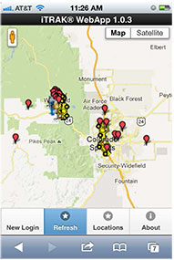
The iTRAK WebApp displays vehicle fleet and landmarks.
iTRAK Corporation, provider of GPS-based tracking, mapping, and reporting solutions, has announced the commercial release of its iTRAK WebApp application. The WebApp provides much of the functionality of the iTRAK Fleet Executive software suite in a mobile environment.
The new application allows iTRAK customers to view all their tracked devices on a wide variety of smartphones and tablets, such as iPhone and Android phones and iPAD tablets. The assets displayed can be tracked using dedicated, in-vehicle GPS devices or GPS-enabled cell phones. Managers and supervisors who regularly work out of the office can still view the location of the vehicles for which they are responsible, as well as historical location and stop data and user-defined landmarks. The mapping system is integrated with Google global street and satellite maps.
iTRAK has been offering mobile fleet management solutions since 2007, when iTRAK FleetFinder, a system to display mobile assets on a Blackberry, was released. The iTRAK WebApp is a response to the convergence of multiple applications on mobile devices, and to customer requests for a mobile fleet management system that will support multiple platforms and operating systems.
The iTRAK WebApp will run on devices that use Apple OS 5.1, 6.0, and 6.1, Android OS 4.0, 4.1, 4.2, and Blackberry 10. Future releases will add geofencing, stored, user-defined map views, and route display. Nine languages are supported: Arabic, Dutch, English, French, German, Italian, Polish, Portuguese and Spanish. There is also an API to the system that allows for third-party integration. Enterprise versions of the cloud services and server software are also available.
iTRAK Corporation (formerly Data Burst Technologies) was founded in 1995 as a developer of GPS-based wireless tracking and AVL systems. The company’s principal offices and network operations center are located in Woodland Park, Colorado.
Entitling its release “From Orbit with Love,” the European Space Agency (ESA) proudly announced today, March 12, 2013, that the first four satellites of the future Galileo Satellite Navigation constellation achieved their first-ever autonomous position fix. The positioning was replicated and confirmed by a team at the NavSAS group of Politecnico di Torino, Italy.
The obtained accuracy lies in the 10-meter range, according to ESA. ESA added that considering the infrastructure is only partly deployed, this fulfills expectations. As with GPS or any satellite navigation system, a minimum of four satellites is required to make a position fix in three dimensions.
The position fix was obtained by ESA’s navigation laboratory in the Netherlands, using the four satellites, launched in October 2011 and 2012, and the Galileo programme’s ground infrastructure, consisting of control centers in Italy and Germany and a global network of ground stations.
“This fundamental step confirms the Galileo system works as planned,” read the official statement.
“Once testing of the latest two satellites was complete, in recent weeks our effort focused on the generation of navigation messages and their dissemination to receivers on the ground,” explained Marco Falcone, ESA’s Galileo system manager.
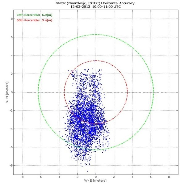
Measurements of individual Galileo horizontal position fixes performed for the first time using the four Galileo satellites in orbit plus the worldwide ground system between 1000 and 11:00 CET on Tuesday 12 March 2013, showing an overall horizontal accuracy over ESTEC in Noordwijk, the Netherlands, of 6.3 m.
This first position fix of longitude, latitude, and altitude took place at the Navigation Laboratory at ESA’s technical heart ESTEC, in Noordwijk, the Netherlands, early on the morning of March 12, with an accuracy between 10 and 15 meters, which was expected, taking into account the limited infrastructure deployed so far.
“The test of today has a dual significance: historical and technical,” notes Javier Benedicto, ESA’s Galileo project manager. “From the historical perspective, this is the first time ever that Europe has been able to determine a position on the ground using only its own independent navigation system, Galileo. From the technical perspective, generation of the Galileo navigation messages is an essential step for beginning the full validation activities, before starting the full deployment of the system by the end of this year.”
With only four satellites for the time being, the full Galileo constellation is visible at the same time for a maximum two to three hours daily. This frequency will increase as more satellites join the constellation in orbit, along with extra ground stations coming online, for Galileo’s early services to start at the end of 2014.
The European Commission’s program head for Galileo, Paul Flament, granted an interview last week with GPS World, recapping the coming launch activities and expectations for initial and full operational capabilities, the latter with a target constellation of 30 satellites. The interview will appear in the April issue of the magazine, which is specially devoted to Galileo and European navigation initiatives.
With the validation testing activities under way, users might experience breaks in the content of the navigation messages being broadcast, said ESA. In the coming months the messages will be further elaborated to define the offset between Galileo System Time and Coordinated Universal Time (UTC), enabling Galileo to be relied on for precision timing applications, as well as the Galileo to GPS Time Offset, ensuring interoperability with GPS.
Galileo Is Real, and NavSAS Has the Evidence
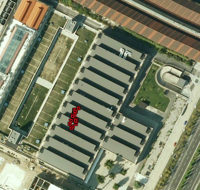
Almost simultaneously with the ESA announcement, the NavSAS group of Politecnico di Torino and Istituto Superiore Mario Boella in Turin, Italy, also achieved a position fix using the signals of the four In-Orbit Validation Galileo satellites (PFM, FM2, FM3, FM4) that started today to broadcast a valid navigation message. The researchers of the NavSAS team successfully computed the positions by using full software receivers developed by the team.
The positions obtained are depicted in Figure 1, as red squares on the rooftop of the NavSAS Lab in Turin, Italy, where the antenna is positioned (latitude 45°03’54.98767″ N, longitude 7°39’32.28920″ E, height 311.9667 meters). The navigation message was first successfully decoded at 11.28 on March 12.
Figure 1. Position fixes on the rooftop of the NavSAS lab in Turin, Italy.
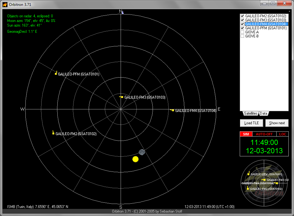
The configuration of the four Galileo satellites as seen by the NavSAS lab is reported in Figure 2.
Figure 2. Skyplot of the Galileo IOV satellites at the time of the data acquisition for the fix.
The NavSAS team was earlier among the first research teams worldwide able to receive and process the signal of the PFM and FM2 satellites, in December 2011 after the launch of the earliest Galileo IOV satellites, and again at the end of 2012 for the FM3 and FM4.
The milestone in both accounts of Galileo-only positioning is that it is real-time positioning using the Galileo navigation message. Galileo positioning using a post-processing mode had already been demonstrated, and described by Peter Steigenberger, Urs Hugentobler, and Oliver Montenbruck of the Technische Universität München and the German Space Operations Center, in an account in GPS World, February 2012 issue. (scroll down to “First Demonstration of Galileo-Only Positioning”).
IFEN GmbH, based outside of Munich, Germany, has established IFEN Inc. in the United States. The new U.S. company will address the needs of the American market for GNSS test equipment, IFEN said.
“IFEN Inc., located in Corona, California, will greatly facilitate order placement, delivery and support for U.S. customers,” said Günter Heinrichs, head of Customer Applications and Business Development, of IFEN GmbH. “We look forward to addressing the needs of this market.”
IFEN has appointed of Mark Wilson vice president of sales at IFEN Inc. Wilson has more than 20 years of experience in the GNSS market. “I am very excited to join the IFEN team. They have extensive experience in all aspects of GNSS and I am looking forward to offering this expertise and the excellent IFEN products to the American Market,” Wilson said. “Our exceptional products offer unrivaled flexibility and capability, at realistic prices providing huge advantages to our customers.”
IFEN has more than 15 years of experience in GNSS and offers a range of GNSS test equipment, including simulators capable of simulating all GNSS constellations and frequencies and a multi-GNSS software receiver.
The Institute of Navigation (ION) Military Division has canceled this year’s Joint Navigation Conference (JNC), which was scheduled to take place in Orlando, Florida, June 10-13.
“This decision has not been taken lightly but due to the DOD’s recent policies detailing actions to be taken to prepare for drastic budget cuts, the curtailment of travel, fallout from a scandal with GSA conferences this past year, the current sequestration, and possible furloughs for federal employees, it is no longer possible for ION to ensure the JNC will be able to maintain a high-quality technical program and sufficient networking opportunities that makes the JNC so valuable to DOD/DHS employees and their supporting organizations,” wrote Lisa Beaty, ION executive director, in a statement.
“While it is impossible for us to predict the duration of the current federal climate, the ION is committed to keeping the Institute on a sure and steady track,” Beaty wrote. The 2014 JNC is still scheduled for June 16-19, 2014, at the Renaissance Orlando at SeaWorld, Orlando, Florida, with the classified session and warfighter panel being held at Shades of Green at Walt Disney World Resort on June 19.
All JNC 2013 registered attendees, exhibitors, and sponsors will receive a full refund of fees paid. Registrants and exhibitors are reminded that they are responsible for cancelling their own hotel reservations, and other travel-related arrangements. To cancel reservations at the Renaissance Orlando at SeaWorld, call 1-407-351-5555 or 1-800-327-6677, or cancel your reservation online.
The 2014 Rolls-Royce Wraith coupe is using GPS to make a smooth ride even smoother.
Unveiled at the 2013 Geneva Motor Show, the Wraith is the fastest, most powerful car Rolls-Royce has ever made at $320,000 ($245,000 euros). The Wraith’s eight-speed automatic transmission is linked to a GPS receiver. The car uses satellites to constantly determine what road you’re driving on and in what conditions, then uses the data to anticipate when to shift gears.
For example, it can downshift the moment a hill or curve is approached, which helps with both performance and fuel economy, Rolls said. The nav system also compiles real-time traffic data from cellphones in commercial vehicles and taxis, and uses the data to update the travel route every three minutes.
The debut of Satellite Aided Transmission technology takes the power train to a new level of effortless delivery, the automaker said, allowing the car to “see into the future.”
According to the Rolls, Satellite Aided Transmission uses GPS data and the navigation system to scan the road. It anticipates his next move based on location and current driving style, then automatically chooses the optimum gear on the eight-speed transmission. “Power is delivered effortlessly for you, so you can surge through every corner, round every roundabout and into every slip road smoothly,” Rolls-Royce said.
The high-tech doesn’t stop with GPS. The Wraith has a heads-up display, voice command support and an infotainment system with multi-touch trackpad and 10-inch screen.
Start saving your pennies. The Rolls goes on sale this fall.
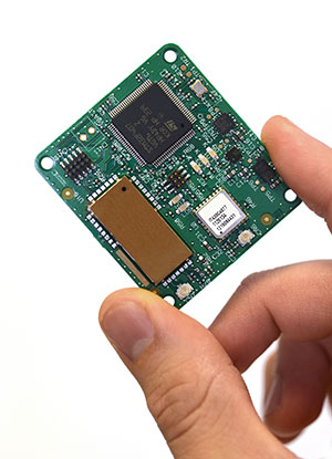
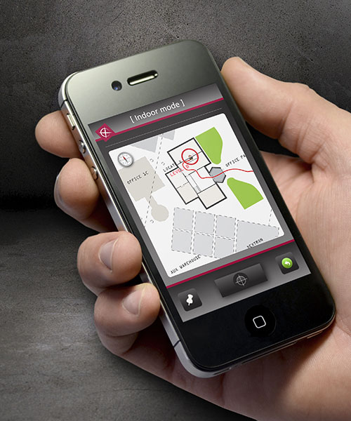
New technology from product development firm Cambridge Consultants can accurately detect someone’s location indoors when GPS drops out. A number of sensors and a custom algorithm determine the location, with an accuracy of within approximately 1 percent of the distance traveled.
The technology uses low-power, low-cost sensors and the device concept is small enough to clip on a belt. It also doesn’t need any existing internal infrastructure.
“We are excited about the many possibilities this cutting-edge technology opens up and the impact it can have in many different situations,” said Geoff Smithson, technology director, sensing systems, at Cambridge Consultants. “It could be used to help locate firefighters in smoke-filled buildings, for example, or to pinpoint the closest doctor in a hospital during an emergency — or to track offenders during home curfews. We are just starting to see the potential of this approach and the diverse demand for this type of low-energy, highly accurate system.”
Indoor tracking systems, which process data from one or more sources of location information to estimate where a person or object is located, are not new. But they often rely on RF signals from Wi-Fi access points or custom infrastructure, poor-quality GPS signals or expensive, high-quality sensors. The availability of low-cost smartphone components — including accelerometers, gyroscopes, magnetometers and pressure sensors — has enabled a new generation of location devices and applications, when combined with a tailored Bayesian algorithm to fuse the information.
The new technology platform can be embedded in an existing design or operate as a stand-alone unit, with options to compute the location locally or transmit the information to a remote system that can process the data before visualizing it on a smartphone app.
“Our biggest challenges were developing an algorithm which optimally combines the data from GPS and the other sensors, and overcoming the issues of using such low-cost sensors in a system without any absolute location reference,” said Smithson.
Cambridge Consultants specializes in developing low-cost, low-power connected devices for clients with a team of experts with sensing, wireless and software engineering expertise. The latest technology builds on the company’s tracking and location systems experience in a variety of market sectors ranging from defense and security to consumer, industrial, and oil and gas.
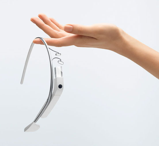
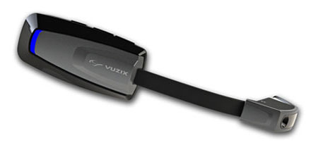
Vuzix Corporation today announced that it has begun shipping M100 Smart Glasses to the first of its Gold developer partners — enabling them to start creating and testing their apps on the real hardware.
The M100 Smart Glasses are a smart hands-free display and communications device for mobile data access, once paired to a smartphone and connected to the Internet. The glasses include an integrated head tracker and GPS for spatial and positional awareness.
Vuzix is a supplier of Video Eyewear products in the consumer, commercial and entertainment markets.
Google Glass
The M100 is in competition — and a race to market — with Google Glass, a similar wearable device. Google recently held a contest to provide sample sets of the glasses to non-developers willing to pay $1,500 — which encouraged Internet and media buzz.
M100 Smart Glasses
Google Glass could be released to the mass market by the end of the year. Google Inc. already sold an unspecified number of the glasses to developers who also paid $1,500 apiece at a company conference in June 2012. The mass-market version of Google Glass is expected to cost less than $1,500, but more than a smartphone.
Like the M100, Google Glass is intended to perform many of the same tasks as smartphones. The glasses include a little display screen attached to a rim above the right eye, run on Google’s Android operating system, and respond to voice commands, which is intended to make it easier for people to take pictures or record video wherever they might be (such as skydiving or riding a rollercoaster). Here is a video showing the glasses in action:
When he demonstrated the glasses at last June’s company conference, Google co-founder Sergey Brin acknowledged the company was still working out bugs and trying to figure out how to extend the product’s battery life.
Privacy Concerns. The ease of taking pictures and recording video with the glasses is causing some to question whether privacy will be affected. zdnet blogger Ben Woods writes, “These glasses can instantly capture and store every move of everyone around the person wearing them. Remember that drunken argument you had with your partner? Well, now Google Glass will mean you have no possibility of forgetting it. If it’s entertaining enough, or you’re well-known enough, the video of that argument could well be on YouTube before you get home. Do you do a lot of business on the phone while out and about or while sitting in coffee shops? Will you continue to, if you know that every call could be recorded by the stranger sitting at the table opposite, staring innocently at the picture on the wall behind your head?”
Google first began developing the glasses in 2010 as part of a secretive company division now known as Google X.
How the M100 is worn.
Vuzix Showstopper. Displayed at Mobile World Congress in February as a “Showstopper,” the M100 contains a near-eye micro display with an integrated camera and powerful processor running an Android OS. It connects wirelessly to a user’s smartphone (iOS or Android) or other compatible device via Bluetooth or Wi-Fi, can connect directly to the Internet, and run applications and games on its own. Working in harmony with a user’s smartphone, the M100 enables access to a vast array of existing and future text, video, GPS, and audio applications, Vuzix said.
With the glasses, users can answer the phone using a visual address book, record video and run applications, including basic augmented reality apps. Interactive tracking and an integrated camera, combined with newly developed applications on the M100 and a wireless link to the Cloud, enable the merging of virtual information with the real world. An integrated camera enables video recording, still image capture and the potential for powerful augmented reality applications.
Industry, Medical. “Although we are seeing applications developed in most every market, there has been a strong focus on the industrial and medical markets,” said Paul J. Travers, chief executive officer.
“Our Company has a focus on developing the fundamental tools that enable applications from training to warehousing,” said Pete Wassell, president of Augmate Corporation, one of the first M100 Gold developers. “This new category of device is going to revolutionize many markets by injecting cloud-connected, hands-free and geospatially accurate information to applications that desperately need it. The M100 does a great job of delivering on that promise.”
The Vuzix developer program offers early access to the M100 smart glasses, technical support and advice. The M100 software developers kit is available in two versions, Gold and Silver. These SDKs are being delivered in stages and include frequent updates, hardware advances when released, and access to the developer center to provide technical and developer community support.
Because the demand is strong, Vuzix is delivering the first smart glasses on a first-come, first-served basis with custom-built prototypes going exclusively to its Gold Developers.
Broadcast Date: Thursday, March 7, 2013
Speaker: Steve Fossi, Director of New Business Development, Symmetricom
Panelist: Ravi Pragasam, Marketing Manager, Embedded Solutions, Symmetricom
Webinar Topic/Abstract: Precision timekeeping with all the benefits of Size, Weight and Power (SWaP) – Quantum(tm) SA.45c Chip Scale Atomic Clock (CSAC)
Atomic clocks have enabled a world where ultra-precise timekeeping is now mandatory for communications, navigation, signal processing and many other applications critical to a modern functioning society. While smaller, lighter and more energy efficient solutions have been introduced to serve the above markets, the atomic clocks used in these systems have not kept in pace and continue to use more power and retain their large form factors. Symmetricom, the industry leader in precise time solutions, has utilized leading edge technology and multiple innovations in various disciplines such as semiconductor laser technology, silicon processing, vacuum-packaging and firmware algorithms to deliver the Quantum SA.45c CSAC (Chip Scale Atomic Clock). The CSAC is small in size, has low weight and consumes very little power. Such an atomic clock with excellent precision in time keeping is ideal for applications that have a constrained power budget and demand a very low-power clock.
Attend this webinar and learn how the CSAC can address your requirements for a precise clock without consuming excessive power or taking up too much space in your application.
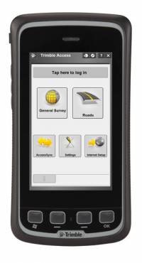
Trimble has introduced an all-in-one device for mobile communications and surveying data collection — the Trimble Slate Controller. The Trimble Slate Controller combines the convenience and ease-of-use of a smartphone with rugged durability. Optimized for Trimble Access field software and the Trimble R4 GNSS receiver, the Trimble Slate Controller supports a surveyor’s everyday workflows.
“Surveyors require mobile, rugged solutions that can readily withstand and perform in the toughest of conditions,” said Erik Arvesen, vice president of Trimble’s Survey Division. “With the introduction of the Trimble Slate Controller, we are providing a rugged handheld device designed to run survey workflows while also delivering the capabilities and convenience of a smartphone.”
Offering voice, SMS text, and 3.75G cellular data transfer capabilities on GSM cellular networks worldwide, the rugged Trimble Slate Controller enables enhanced connectivity in the field. Its wireless communication capabilities keep surveyors connected to the office. An integrated 8-megapixel camera offers enhanced job documentation and point attribution by providing geotagged, high-quality digital photos.
The Trimble Slate Controller’s slim, ergonomic design is easy to hold while its screen provides superior sunlight readability enabling all-day use by survey professionals. Designed to withstand even tough conditions, a 4.3-inch capacitive touch Gorilla glass display covers the entire front surface, increasing readability without sacrificing durability.
Trimble Access field software available on the Trimble Slate Controller offers a variety of features and capabilities to streamline topographic, stakeout, control and other surveying applications. Partnered with Trimble Access and the Trimble R4 GNSS receiver, the Trimble Slate Controller provides a dedicated GNSS solution that is effective for both real time and post-processed GNSS surveys, Trimble said.
GPSTrackIt has released a fleet management tool called Driver, a website that enables drivers using tablet devices such as iPads and Androids to send and receive messages and plan routes.
The site provides drivers with two-way communication by chat or forms with dispatchers and fleet managers. It also provides them with route management and timekeeping utilities. Driver compliments GPSTrackIt’s recent releases for smartphones and tablet apps for dispatchers and fleet managers.
According to Eddie Bermudez, product manager, GPSTrackIt’s vehicle tracking system has been enhanced with Field Service Manager (FSM). “The FSM is the control center for all of the mobile workforce management tools available through the Driver website. Dispatchers and fleet managers use the Field Service Manager to create and send messages. The can build Quick Messages and Quick Responses that drivers can select from a list. They can also create forms with multiple questions, and multiple choice answers that streamline the communications process.”
Dispatchers enter stops and build routes using the FSM. The routes can be rearranged as new stops are added, saving drivers time and reducing the need for them to call in. The routes are pushed out to the drivers, who can then display them on maps and list out the directions. They can also use a third-party navigation app to render true turn-by-turn directions.
Soon Driver will provide route optimization. “Driver will look at all the stops and do the arranging for you,” said Bermudez. “It will evaluate the relative distances and calculate the most efficient route.”
In addition, the FSM also provides a mobile time clock. “This enables drivers to clock in and out using the tablet,” Bermudez said. “That data, as with the chats, stops, and forms, can be reported on using Fleet Manager’s reports. It provides fleet managers with a verification tool for employee timekeeping.”
One of the other advantages to using a tablet device is that it offers users a wide variety of useful mobile apps.
“Tablet devices provide our customers with a platform that not only connects them to the Fleet Manager system, but many other productivity tools,” adds John Stull, President and founder of GPSTrackIt. “Drivers can make use of other apps and peripherals to do credit card transactions, scan and transmit contracts, and perform many other important tasks.”