Hitec Commercial Drone Services expects to provide training, precision aerial missions and comprehensive data collection to a variety of industries, including
agriculture, construction, excavation, mining and aggregates, oil and gas, engineering and surveying, public safety and many other vertical sectors. Hitec maintains a fleet of unmanned vehicles. It offers proprietary mission-control software and data and photogrammetry collection techniques with its comprehensive unmanned aviation experience.
The new division’s field services director is Jim Bonnardel, an innovative entrepreneur with a history steeped in unmanned flight. Bonnardel established his own successful business in 1982, providing aerial services to business-to-business entities. His inventive nature and extensive flying prowess led him to become a certified and insured UAS service pilot and instructor.
Bonnardel has logged more than 1,750 precision mapping missions, inspected 2,000 utility structures, and flown more than 2,500 commercial and residential property shoots, as well as dozens of missions for creative projects involving both television and music videos.
He is also an instructor at Grossmont College in El Cajon, California. He has provided 850 hours of commercial instruction, as well as 550 hours of instructional field training and vetting for utility inspection crews. As a result of his training experience, Jim has issued 150 sUAS Utility Training Certificates.
UAV Navigation has launched the VECTOR-400, a compact autopilot designed specifically for unmanned aerial targets (UAT). It features a robust enclosure and a military-grade connector designed to withstand the harshest environments, in accordance with MIL-STD 810 and MIL-STD 461.
“We wanted to develop a solution specifically for manufacturers of aerial targets,” said Tobias Webster, managing director of UAV Navigation. “That is why it was important for the autopilot to have the features required by this kind of UAV, such as sea-skimming (extremely low-level flight) or the capability to navigate without a GNSS signal.”
Thanks to its physical and logical redundancy, the VECTOR-400 is able to continue a mission in case of individual sensor failure and even when subject to jamming, maintaining accurate estimations of attitude and position. It features advanced algorithms for stall prevention and the ability to carry out an efficient gliding maneuver in case of engine failure.
The VECTOR-400 uses an air data attitude and heading reference system (ADAHRS) and inertial navigation system (INS) developed by UAV Navigation, which provides high precision attitude information and which allows reliable navigation even under the most demanding circumstances.
The ADAHRS gives the VECTOR-400 the capability to operate in GNSS-denied environments (less than 30 m/min drift) and also to execute highly dynamic maneuvers.
“The VECTOR-400 is not a product in isolation, rather it forms part of our global strategy. Some of its main features, such as the execution of completely automatic functions or its compact and easy to integrate software, which also allow it to be operated in case of data-link failure, are already used in other products in our autopilot family, such as the VECTOR-600” explained Webster.
In addition to its advanced technology, the VECTOR-400 benefits from the same stringent quality standards that UAV Navigation insists upon for all of its products. The company carries out rigorous calibration processes and acceptance testing on every single unit before it ships, together with its individual certificate of conformity.
UAV Navigation has designed the VECTOR-400 to meet MIL-STD 810 and MIL-STD 461 standards. The design and development of its software and hardware has been carried out in accordance with DO-178C, DO-254 and also ASTM F3201-16 — a certification available for unmanned aerial systems.
“Not all autopilots are able to control highly dynamic platforms; even fewer are able to carry out advanced, high-speed maneuvers and low-level flight such as sea-skimming,” Webster said. “That is why we are extremely pleased with this new product, which we believe meets a requirement in the market that had yet to be covered.”
Effective July 2, the Brandt Group of Companies successfully acquired the assets of Ontario-based Sokkia Canada in a deal with owner Topcon Positioning Systems.
The acquisition, which directly affects the Ontario and Quebec markets, makes Brandt the exclusive dealer for Sokkia optical survey instruments, accessories and parts for the Canadian market.
The news signals Brandt’s entry into Central Canada’s geopositioning technology market and is the latest in a growing list of acquisitions and dealer agreements made by the Regina, SK-based company since its purchase of Ontario/Quebec/Newfoundland and Labrador John Deere Construction & Forestry dealer Nortrax in late 2019.
“Expanding our Sokkia offering into Ontario and Quebec has been a high priority for Brandt,” said Brandt CEO Shaun Semple. “Central Canada is an important new market for us and we are 100% committed to delivering exceptional value for the survey, engineering and construction industry here. This addition is a big step forward for us.”
The survey-focused Sokkia brand has a 100-year history and is owned and marketed by Topcon Positioning Systems, a U.S.-based division of Japanese precision equipment manufacturer Topcon Corporation.
The Sokkia product lineup will be distributed and supported through the company’s Brandt Positioning Technology division and includes total stations, GNSS receivers, data collectors, digital levels and a full complement of field accessories.
The move will consolidate Sokkia distribution for the first time under one banner and will further establish the Brandt’s position as a premier privately-held Canadian company.
The Brandt Group of Companies — headquartered in Regina, Saskatchewan, Canada — is comprised of Brandt Agricultural Products, Brandt Engineered Products, Brandt Equipment Solutions, Brandt Road Rail, Brandt Positioning Technology, Brandt Truck Rigging & Trailers, Brandt Finance, Brandt Developments Ltd., Brandt Road Technology, Brandt Mineral Technology and Brandt Tractor Ltd. (the world’s largest privately owned John Deere Construction & Forestry equipment dealer.)
Brandt has more than 100 locations in Canada and the U.S., more than 3,400 employees, and a growing international customer base. It serves the construction, forestry, agriculture, rail, mining, steel and energy industries.
By David Zilkoski, contributing editor, survey scene
David B. Zilkoski
I attended The Ohio State University (OSU) to obtain my graduate degree in Geodetic Science in 1979. Therefore, I will admit that I am a little biased — once a geodesist, always a geodesist. The basic definition of geodesy is the applied science for determining the size and shape of the Earth, designing and realizing reference frames, and determining where you (and anything else) is on the Earth.
In OSU’s geodesy heyday (1960–1990s), many Americans trained were sent by federal agencies: National Geospatial-Intelligence Agency (NGA), NOAA/National Geodetic Survey (NGS), USGS, Army, Navy and Air Force. During the 1970s, NGS was sending two employees back to school every year. These agencies needed geodesists because they were undertaking major projects such as NGS’ to readjust the U.S. national horizontal (NAD83) and vertical geodetic (NAVD88) networks.
I was one of the employees that NGS sent to OSU to be trained to support the NAD83 and NAVD88.
The advancements in satellites and computers have enabled geodesy to expand into many different disciplines. Geodetic science and technology now underpin many sciences, large areas of engineering (such as driverless vehicles and drones), navigation, precision agriculture, smart cities and location-based services. Geodesy is actually more important than ever.
Today, the environment is different. U.S. federal agencies still need geodesists for developing enhanced and refined geodetic models and tools. However, major U.S. companies, such as Google and FedEx, as well as the automobile industry, precision farming companies and mining companies also need more accurate geodetic models, tools and algorithms. Therefore, these companies also need trained geodesists to perform important research on topics that address their specific geodetic requirements.
Today, OSU’s Geodesy Department is training very few American citizens. As the U.S. moves toward achieving geodetic-grade positioning in real-time in support of new applications such as driverless vehicles and drones, the number of trained geodesists should be increasing, not decreasing [Note: In 1990, there were 92 geodetic science graduate students. In 2019, there were 25; only three were U.S. citizens]. OSU and other universities need to educate and train the next generation of the nation’s scientific workforce of highly skilled research geodetic scientists that will expand industry’s research expertise.
The shortage of American geodesists poses a significant economic risk for the U.S. Europe and China train many more geodesists than the US. There are very few geodetic science programs in the U.S. today, and education in geodetic proficiencies has been fragmented. The OSU graduate program is one of few surviving geodetic science programs.
Users of geodetic products and services need to support geodetic departments in universities so that U.S. geodesy programs can grow to meet the geospatial demands of the future. The geospatial component of the economy is worth about $500 billion/year. So why are we allowing its foundational discipline to shrink in this country?
Atlantic — a remote sensing, surveying and consulting business — has purchased a Phase One Industrial 280MP large-format aerial solution to better serve its clients. The upgrade substantially increases Atlantic’s ability to efficiently capture a large area with extreme accuracy and quality.
Photo: Phase One Industrial
The massive Phase One Industrial 280MP aerial solution is a large-format camera system that easily integrates with smaller gyro-stabilized mounts creating a compact d lightweight system for use in a wide range of aircraft.
At its heart, the iXM-RS 280F is a dual-lens metric camera, with 90mm lenses for capturing RGB information, adding a near infrared (NIR) camera generates a four-band configuration, useful in agriculture, forestry and pipeline monitoring missions.
The iXM-RS280F camera has an image coverage width of more than 20,000 pixels whilst the cameras’ backside illuminated CMOS sensor supports very high dynamic range at 83dB. Its high light sensitivity provides superb image quality in challenging low light conditions, enabling operators to take advantage of more flight hours per day and more flight days per year.
“We’ve been using Phase One’s camera technology for over two years combined with our Optech lidar systems,” said Brian Mayfield, president and CEO of Atlantic. “We are very impressed with the technology and applaud Phase One’s innovative approach to designing a high-quality large format camera that produces exceptional results. The Phase One 280MP is yet another forward-looking technology resource that we’ve added to provide the most complete and cost-effective geospatial solutions for our clients.”
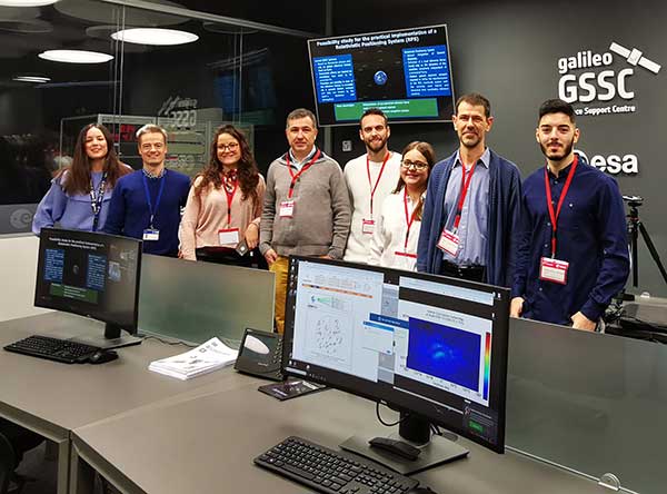
GMV will search using artificial intelligence for any correlations between COVID-19 spread and environmental parameters.
Image: ESA
The European Space Agency (ESA) has launched an internal initiative to cull ideas for supporting its member states in the study and analysis of the COVID-19 pandemic. Under this initiative, an idea from the Galileo Navigation Science Office has been selected.
The COVID-19 Space Hunting Platform is designed to facilitate access to and processing of existing COVID-19 databases for epidemiological studies, topping them up with data from ESA’s Earth observation satellites.
The project will use artificial intelligence to look for correlations between COVID-19 spread and environmental parameters, such as humidity and temperature.
The aim is to help researchers generate products and statistics that might be useful for decision-making purposes in terms of protection measures and lockdown, while also vetting the efficiency of the measures taken.
Development of the COVID-19 Space Hunting Platform will be primed by the technology multinational GMV. The Universidad Politécnica de Valencia will also be taking part, with support for processing, data analysis and interaction with diverse epidemiological research groups. The university has defined a mathematical COVID-19 transmission model and has been publishing periodical updates and forecasts of its trend in Spain.
In the medium term, the COVID-19 Space Hunting Platform could help in setting up a collaborative COVID-19 website for scientists to analyze existing data more efficiently, benefiting also from ESA’s data-processing software packages.
The GSSC team will lead the program. (Photo: ESA)
The project will be carried out around the GNSS Science Support Centre (GSSC) platform, which hosts and indexes COVID-19 data. The three-month process will analyze public COVID-19 data and make this information available to the science community. This will lead to a first version with basic pandemic-propagation algorithms, updated thereafter to ensure the information is always precise and up to date.
AiRXOS, a provider of unmanned traffic management (UTM) solutions, is providing a comprehensive unmanned aircraft systems (UAS) solution for energy organizations to plan, schedule, operate and monitor all facets of their UAS operations from a single platform.
AiRXOS’ new Enterprise Energy Solution provides digital compliance, full Situational Awareness of airspace and assets, inspection, emergency response/disaster recovery capabilities, analytics, and asset performance tools all in one, connected platform. The Enterprise Energy Solution runs on AiRXOS’ Air Mobility Platform – a secure, cloud-based, extensible platform that enables easy integration of an energy organization’s current applications and other UAS Service Suppliers (USS), as well as supports the full lifecycle of UAS Energy operations.
“Infrastructure inspections with traditional manned aircraft are dangerous, inefficient, and expensive,“ said Mark Lanphear, AiRXOS’ Senior Vice President of Global Sales and Business Development. “Now more than ever energy organizations are looking for solutions to help them deliver safe, scalable, and repeatable operations for greater economic viability. To achieve scale, they need a centralized and standardized view of all operations, manned and unmanned. It’s why we developed the Enterprise Energy Solution – to deliver energy organizations a truly comprehensive platform that brings all UAS lifecycle operations into one view — from enterprise wide infrastructure inspection and surveillance, to asset and crew management, Situational Awareness and emergency operations after a natural disaster — all on one platform.”
AiRXOS’ Enterprise Solution allows energy organizations to combine and integrate all critical inspection needs in one connected ecosystem with automated and feature-rich technology with capabilities including: Automated Waiver, Exemption and Certificate of Authorization (COAs) for safer, faster flying, partner-enabled mission-ready kits with sensors, drones, and pilots as a service, emergency response and disaster recovery application with mass alerts, digital SGI and complete situational awareness, compliance and crew management for reliability and transparency, asset management and security to optimize assets, analytics and insights for near real time actionable intelligence, and program design services to help energy companies launch and grow programs.
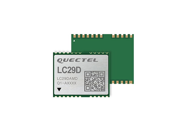
The LC29D is a sub-meter level GNSS module that integrates dead reckoning (DR) and multi-band (L1/L5) real-time kinematic (RTK) algorithm technologies with fast convergence times and reliable performance. The module supports dual-band GNSS raw data output and integrates 6-axis IMU sensor to deliver high-accuracy positioning performance in seconds.
Based on the Broadcom BCM47758 GNSS chip, the LC29D can concurrently receive signals from up to six constellations (GPS, GLONASS, Galileo, IRNSS, BeiDou and QZSS) at any given time, which maximizes the availability of sub-meter level accuracy.
Combining GNSS signals from dual-frequency bands (L1/L5) and RTK technology enables the LC29D to achieve high performance even in difficult conditions such as dense urban canyons. The module can also mitigate multipath effects in urban cities.
The LC29D offers a position update rate of up to 30Hz (fusion output), enabling dynamic applications like shared eMobility, delivery robots and precision agriculture to receive position information with lower latency. By enabling easy integration of advanced RTK multi-band algorithms, the module helps developers quickly bring their devices to market.
The high-precision module offers better performance than products in the market in positioning precision, sensitivity, time to first fix (TTFF), update rates and latency.
Embedded with 6-axis MEMS sensor, devices powered by the LC29D can quickly report motion, which enables consistent high-precision positioning capabilities when combined with the DR algorithm, even in weak-signal environments such as tunnels and underground parking structures.
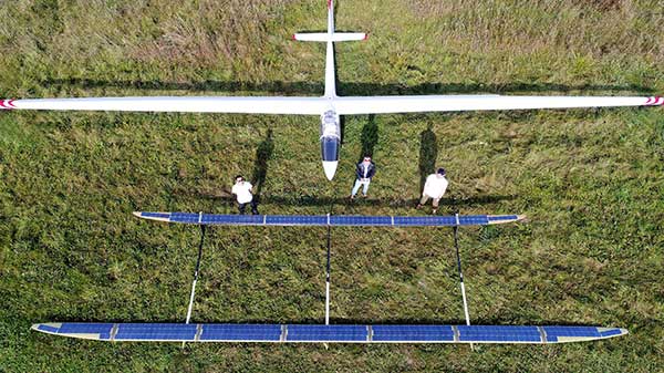
The ApusDuo project is the second generation of UAVOS’ HAPS solar airplane. (Photo: UAVOS)
UAVOS has joined the High Altitude Platform Station (HAPS) Alliance to promote the use of high-altitude solar-powered autonomous aircraft for facilitating global research missions, communication, connectivity, intelligence, surveillance and reconnaissance from the stratosphere.
UAVOS joined HAPS to collaborate with member companies towards accelerating the development and adoption of HAPS technology into the evolution of the high-altitude unmanned platforms market.
UAVOS’s HAPS knowledge is based on test flights for more than 1,000 hours of flight tests at altitudes of up to 66,000 feet (20,000 meters). The ApusDuo project is the second generation of UAVOS’ HAPS solar airplane.
HAPS platforms are autonomous, high-altitude, ultra-long endurance aircraft powered by solar energy. They are designed to boost internet connectivity worldwide, provide a long continuous monitoring of the Earth’s surface, create a network of autonomous repeaters and high-speed data signals. High-altitude unmanned platforms operate in the stratosphere, above ground infrastructure but below satellites, allowing for near ubiquitous coverage, which avoids ground clutter and significant latency issues.
The HAPS Alliance, originally an initiative from HAPSMobile and Loon, has members from the companies across the aerospace, technology and telecom industries.
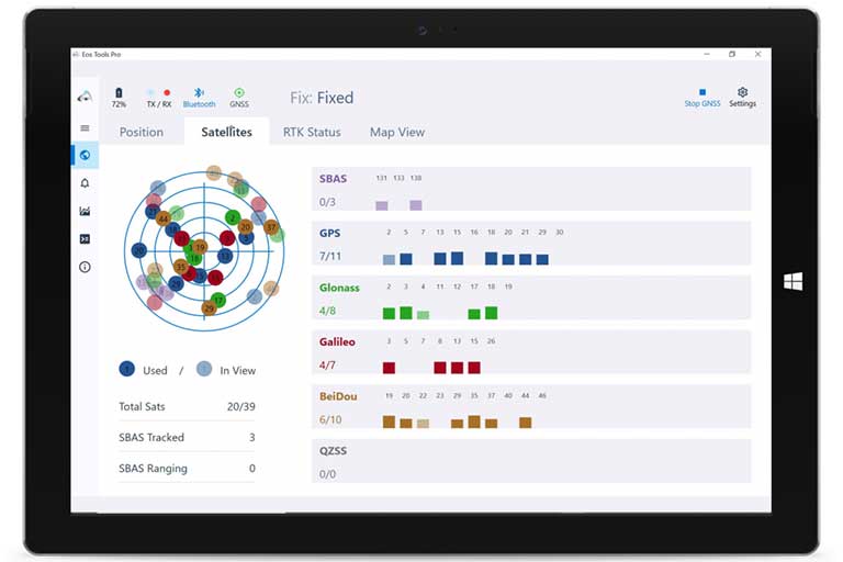
Eos Tools Pro implements powerful new features that enables users to exploit all four global GNSS constellations and a state-of-the-art NTRIP client to access real-time kinematic (RTK) bases and RTK networks all over the world via NTRIP, Direct IP and wireless radios.
“This is a huge step forward in functionality and flexibility for our Windows users,” said Jean-Yves Lauture, CTO of Eos. “We implemented the latest support for Windows Geolocation and other features offered by Microsoft in order to allow our customers to use high-accuracy locations directly into their apps.”
Eos Tools Pro includes new features for both field professionals and application developers.
For field professionals
RTK network/RTK base connectivity. Eos Tools Pro implements state-of-the-art NTRIP connectivity to connect to any RTK network or RTK base in the world. For geographic areas without cellular coverage, Eos Tools Pro supports Bluetooth wireless radios (UHF/VHF, etc.) for base/rover connectivity.
The software supports all new BeiDou and Galileo satellites in addition to GPS and GLONASS as well as SafeRTK functionality for areas with marginal cellular coverage.
Eos Tools Pro for Windows shows all current satellites in use from GNSS constellations such as GPS, Galileo, BeiDou, GLONASS and QZSS. (Screenshot: Eos Positioning)
Geoid models. Eos Tools Pro implements the latest geoid models for many regions in the world, providing survey-grade orthometric heights directly into any Windows applications.
Datum shift. Eos Tools Pro adds a new feature to apply a simple X, Y, Z shift to the current location to match any local datum.
Alarms. A vast number of audible alarms can be set to warn the user if parameters such as estimated accuracy, differential status, correction age, Bluetooth connectivity, are not met.
For Windows developers
Geolocation/Sensor API. Eos Tools Pro supports apps that rely on the Windows geolocation service to retrieve accurate latitude, longitude and altitude from their Arrow receiver. In addition, the Sensor API allows programmers to access the wide array of GNSS metadata while removing the laborious task of parsing NMEA data.
Virtual COM port and TCP/IP server. Eos Tools Pro features a built-in duo of virtual COM port and TCP/IP server to output streams of standard NMEA sentences. This enables multiple apps capable of parsing NMEA messages to have simultaneous access to the Arrow GNSS location and metadata.
“Eos Tools Pro for Windows enables users and developers to benefit from our leading-edge, high-accuracy GNSS receivers,” Lauture said. “When Windows tablets are the device of choice among our customers, the combination of Eos Tools Pro and Arrow GNSS receivers provide the absolute latest GNSS technology for GIS, engineering, construction, and surveying users. When Windows tablets are the device of choice among our customers, the combination of Eos Tools Pro and Arrow GNSS receivers provide the absolute latest GNSS technology for GIS, engineering, construction and surveying users.”
Eos Tools Pro for Windows is available for free to users of Arrow GPS and GNSS receivers. It is compatible with any Windows 10 desktop, laptop or tablet computer via Bluetooth or USB.
By Alexander Meisel, automotive cybersecurity engineer at intive
Alexander Meisel
When it comes to connected cars, automakers are innovating fast. Consumers are experiencing increasing amounts of futuristic features, be they passenger connectivity, automated speed regulation, or autonomous driving capabilities.
However, these innovations and their integration with cloud connectivity come with a heightened risk for cyber attacks. A recent study conducted by U.K. self-driving hub organization, Zenzic, found that becoming cyber-resilient will be the biggest technical obstacle to successfully deploy self-driving cars on roads by 2030. This mountain will be a big one to surmount, and it’s only growing in size: The auto industry has seen a 94% year-over-year increase in hacks since 2016.
So, how can automakers prioritize security while keeping up with the demand for innovation in today’s connected cars?
Carmakers must consider security from day one
To make sure that security is built into the very foundations of a car, automakers must make it a priority from the first day of design. This focus is lacking amongst carmakers at the moment. In fact, 19% respondents to one survey said they don’t do enough security testing in the design phase, and only 28% said that they do a lot of the testing during the design stage.
Automakers can use design principles to build in security from the outset. For example, the principle of complete mediation allows for enhanced security as it ensures that a software stem “requires access checks to an object each time a subject requests access.” This means that attackers are only invited to exploit a system on one single occasion due to checks on subjects’ permissions.
Carmakers can also ensure that they are not sacrificing security by considering its importance when purchasing components from separate suppliers. These components must be specific enough to enable security in the system, but generic enough to allow for innovation.
Here, companies can leverage the software engineering principle of interface segregation. This means that a shrunken, clear interface should be supplied by the vendor, so that the customer only uses the methods that are of interest to them. In turn, this allows systems to remain decoupled and thus easier to then build a rich interface on top of. However, carmakers will have to stay on top of the security of the part in the development phase, and ensure that dormant functions are not abused by at least logging their execution once somebody tries to call them out of context.
Developers and cybersecurity experts must become a core part of the team
Software development is relatively new territory for carmakers. Now, cybersecurity is a key component of building connected cars, and automakers need to embrace developers that have expertise in this area and make them part of the core team.
This cultural change must be championed by the business leaders to allow car security to advance alongside the innovative features that the industry is building. This can be done by implementing DevSecOps ideology into the team, in order to “build the mindset that everyone is responsible for security.”
Car development teams will likely need a group of cybersecurity experts who can educate the rest of the developers and are willing to participate in the development process in order to check and implement safe and secure functions. If a company doesn’t have this kind of expertise in-house, they can partner with an expert third-party to help them along this journey.
Innovation and security can complement each other
Cybersecurity doesn’t mean sacrificing feature innovation: developments are being made in the field of security too, such as biometric technologies that can be integrated into car design.
For example, Blackberry’s QNX technology “has built in concepts for hardware and software trust validation, hypervisor to maintain a separation between the safety critical and infotainment systems, and a core operating system which passes all the functional safety standards,” according to the company’s senior VP SVP, head of QNX, John Wall. Innovation need not suffer at the hands of security, and vice-versa.
In addition, the world’s leading electric vehicle provider, Tesla, ensures security in its cutting-edge, connected cars by sending security updates to cars’ operating systems overnight, and even providing awards for hackers that manage to hack its cars.
Looking ahead to the possibilities of autonomous vehicles (AV) that can drive passengers without needing to have their owner inside, innovation in GPS will be necessary to ensure security and accountability of the car. Potential AV thieves would first look to use GPS data to disable or falsify a car’s GPS system, making it untraceable.
However, carmakers can make this impossible for hackers by not just logging the data in its raw form, but also combining it with other car data using cryptographic algorithms. This ensures that the GPS data remains traceable even after the hardware has been taken apart and sold on the auto-parts black market. In this way, the signature of the original data combined with the GPS position adds an additional layer of security.
Integrating security into connected car design is no simple feat, but it’s a necessary one for carmakers that want to ensure the safety of their passengers while on the roads. By using design principles, diversifying expertise within development teams, and understanding that security and innovation need not be a trade-off, they can do just that.
Alexander Meisel is an automotive cybersecurity engineer at intive. Alexander has a Computer Networking diploma from Hochschule Furtwangen University, and he has developed as a CTO and Development Team Director in previous companies. He has experience with venture capital, successful M&As, product and technical marketing strategies. Meisel is also a public speaker at technical conferences and trade shows.
Latest inertial navigation system serves new customer requirements in autonomous vehicles, mobile mapping, surveying and more
Photo: Honeywell
Honeywell is introducing the HGuide n380, an inertial navigation system (INS) that communicates position, orientation and velocity of an object — such as an autonomous vehicle or unmanned aerial vehicle (UAV) — even when global navigation satellite signals are unavailable.
Smaller, lighter and lower priced than previous Honeywell inertial navigation systems, the HGuide n380 is built using Honeywell’s rigorous design standards to withstand harsh environments in the air, on land or at sea.
“We recognized a need for a small, high-performance inertial navigation system in areas like 3D mapping, surveying and other applications where space is at a premium and performance cannot be compromised,” said Chris Lund, offering management senior director, Navigation and Sensors, Honeywell Aerospace. “We responded by developing the HGuide n380 inertial navigation system, which provides our customers with proven, cost effective inertial sensor technology, created for aerospace applications, but that can be integrated into almost any architecture.”
The new inertial navigation system is composed of Honeywell’s HGuide i300 inertial measurement unit (IMU), a GNSS receiver and Honeywell’s proprietary sensor-fusion software, which is based on the algorithms used for navigation on millions of aircraft every day.
Inputs from these components are fused together to determine position, orientation and velocity to deliver critical navigation information even in areas where a satellite signal is degraded or altogether unavailable, such as canyons, bridges, tunnels, mountains, parking garages or dense forests.
“As the industry evolves, Honeywell’s HGuide suite of IMUs and navigators will be a key enabler of emerging segments like autonomous vehicles, mobile mapping, precision agriculture, robotics and surveying,” Lund said.
During its development, the new product was placed in extreme environments to test ruggedness and was exposed to extensive factory calibration and compensation procedures that help ensure measurement accuracy and performance.
Honeywell has extensive experience in designing and building high-end inertial sensor and navigation systems and has used that expertise to develop a lower-cost portfolio of HGuide offerings to serve new markets and customer requirements.
To date, Honeywell has delivered more than half a million high-performance inertial sensors to serve as navigation aids on an extensive list of manned and unmanned vehicles, which include many air and spacecraft in use today.