Intergeo 2020, originally slated to take place Oct. 13-15 in Berlin, Germany, will now take place entirely virtually. Organizers announced in early June that the show would take place partially in person and partially virtually.
“Due to international travel restrictions, the protection of risk groups and the limited possibilities of people coming together in enclosed spaces, the Intergeo 2020 in its diversity and size is not feasible under the usual circumstances,” organizers said in an email to registrants.
Berlin recently reduced the number of participants of indoor events to 1,000 people, making the show — which attracted more than 20,000 participants in 2019 — unfeasible.
Now called INTERGEO 2020 Digital, the conference will facilitate the transfer of knowledge and exchange of ideas as well as providing “accessibility and opportunity to drop in at the exhibitors.”
Orolia, through its Orolia Government Systems business, has been selected by Raytheon Missiles & Defense to support the U.S. Lower Tier Air and Missile Defense Sensor (LTAMDS) radar program with its low SWaP (size, weight and power), rugged time and frequency system.
Defeating hypersonic weapons
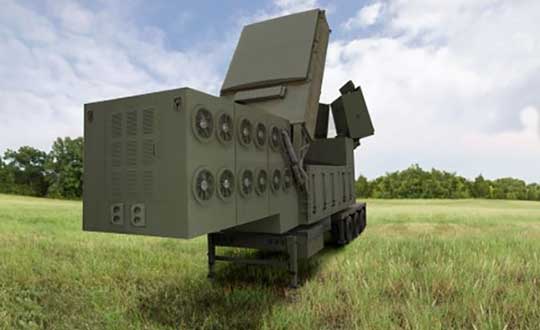
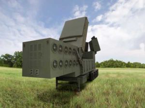
An artist’s rendering of the Lower Tier Air and Missile Defense Sensor (LTAMDS), a next-generation radar meant to help defeat advanced threats like hypersonic weapons. (Image: Raytheon/Orolia)
The LTAMDS system — an advanced air and missile defense radar — will help the U.S. Army defeat advanced threats, including hypersonic weapons. It is a radar designed to defeat advanced and next-generation threats including hypersonic weapons, or those that fly faster than a mile a second.
LTAMDS has three antenna arrays — a primary array on the front, and two secondary arrays on the back. They work together, detecting and engaging multiple threats from any direction at the same time. This results in a battlefield without blind spots, according to Raytheon.
LTAMDS’ primary array is about the same size as the array for the Patriot Air and Missile Defense System, but it has more than twice the power. It is designed for the U.S. Army’s Integrated Air and Missile Defense system, but it will also preserve existing military customers’ investment in the Patriot system.
Raytheon Missiles & Defense was selected by the United States Army in October 2019 to provide the next-generation LTAMDS.
Timing from Orolia
Orolia was chosen for the LTAMDS program based on its core expertise in resilient timing and configurable ruggedized PNT systems for challenging environments, together with its proven track record of successfully delivering time and frequency platforms for other Raytheon Programs of Record.
Orolia was the first company to receive approval for a time and frequency reference system on the Defense Information Systems Agency (DISA) Department of Defense Information Network (DoDIN) Approved Products List for network interoperability, with its flagship SecureSync system.
“Ultra-precise mission timing and sync technology are fundamental building blocks for the Resilient PNT systems that warfighters rely on for continuous operations in contested environments,” said Hironori Sasaki, president of Orolia Defense & Security. “We are proud to be a Raytheon Missiles & Defense partner on LTAMDS and other programs that utilize GPS signals for timing, frequency and network synchronization across critical military systems.”
From critical timing solutions to GPS/GNSS simulation, interference detection, and mitigation, Orolia is an industry leader in end-to-end NAVWAR and Resilient PNT solutions to protect, augment and strengthen military systems for GPS-denied environments.
Orolia Defense & Security provides resilient PNT solutions and custom engineering services to U.S. government agencies, defense organizations, and their contractors, and is authorized to work on the full spectrum of U.S. government classified and unclassified projects.
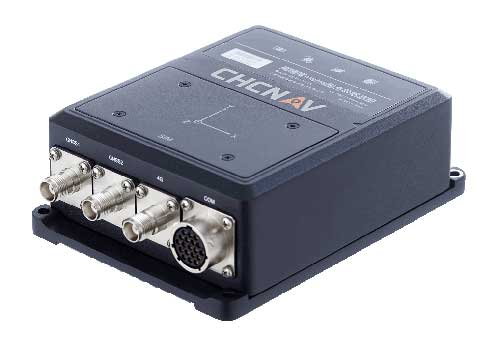
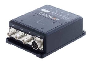
CHC Navigation has released the new CGI-610 GNSS/INS sensor, a high-precision dual-antenna receiver offering reliable and accurate navigation and positioning solutions for demanding land, marine and aerial applications.
The tight fusion of the latest GNSS technology with an industrial-grade MEMS IMU is powered by CHCNAV’s algorithms to deliver accurate hybrid position, attitude and velocity data, even in complex and obstructed environments where GNSS outages can occur.
The CGI-610 is a powerful GNSS/INS system supporting data output up to 100 Hz to meet the requirements of highly dynamic applications (including airplane, train and automobile). The optional external odometer sensor for ground vehicles can provide an additional independent measurement of displacement and speed, which is fused with the GNSS/INS navigation solution.
“The CGI-610 GNSS/INS sensor is the perfect answer to the growing demand of robust positioning and navigation systems for the control of any unmanned vehicle and machine, as well as for highly dynamic applications,” said George Zhao, CEO of CHC Navigation. “Industrial system integrators in need of a reliable GNSS/INS sensor with an exceptional price/performance ratio would definitely consider our CGI-610.”
With its 4G modem, CAN and serial ports, the CGI-610 GNSS/INS sensor offers unparalleled compatibility to enable a wide range of applications including machine control, port automation, advanced trajectography, robotics and unmanned vehicles. The CGI-610’s industrial design ensures reliable and consistent operation in the harshest environments.
Not surprisingly, the primary topic at the July 1 meeting of the National Space-based Positioning, Navigation and Timing Advisory Board was the Federal Communications Commission (FCC) decision on Ligado Networks.
In it Captain Sullenberger cited many of the issues the board’s vice chair, Brad Parkinson, discussed later in the meeting. Sullenberger’s statement is available here.
In his presentation, Parkinson called the FCC decision “a grave error.” He outlined his rationale in 21 information-packed slides.
Parkinson summarized his presentation up front with three points:
Repurposing the Mobile Satellite Services (MSS) radio spectrum is very high risk and brings virtually no near-term benefit to the United States.
The risks affect much more than the Department of Defense: high-value civil applications are also in jeopardy.
Any such repurposing should have been subject to a formal rulemaking process.
At the end of the presentation, the board voted unanimously to adopt the presentation, with slight modifications, as a reference document for posting on the board’s website.
The group had previously made strong recommendations to the Departments of Defense and Transportation to oppose any such action by the FCC. Both departments have done that and are continuing to do.
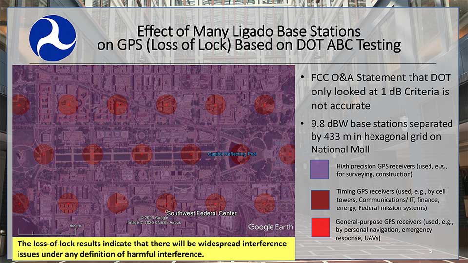
Hazardous information versus losing lock
One slide in Parkinson’s presentation included a Department of Transportation (DoT) depiction how of Ligado transmissions would cause several types of receivers to “lose lock.” This graphic was used in a recent DoT presentation to the FCC.
DOT briefing to FCC: “Concerns Over Ligado Order & Authorization,” June 2020. (Slide: DOT)
Heretofore DoT has usually discussed the points at which Ligado transmissions would cause a 25% increase in the noise floor for receivers. This is an important metric as tests have shown that beyond that point many receiver types begin to give hazardously misleading information. DoT officials have used the example that the 1dB limit is like putting a load limit on vehicles crossing a bridge so that the bridge never reaches its breaking point. An important consideration with a safety-of-life application like GPS.
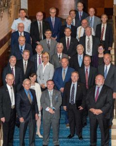
The National Space-Based PNT Advisory Board. (Board photo)
A receiver often gives inaccurate positioning and timing data, possibly hazardously misleading information, before it “loses lock” and stops providing any information at all. It is more difficult for a receiver to “acquire lock” than to track satellites and provide information, so equipment is rarely able to function again until it moves out of the area of interference.
When asked why DoT would bother to show such information to the FCC, one official suggested that loss of lock was more in line with the criteria the Commission used in making the Ligado decision. The hope was that, by showing that even this flawed standard had significant impacts which the FCC perhaps did not fully recognize, further technical discussions and reconsiderations could be realized.
Other Topics
While discussion of the FCC’s decision took the most time in the on-line meeting, several other issues were discussed as well.
Colonel Curtis Hernandez from the National Security Council briefly described development of a new space-based PNT policy to replace NSDP-39 which was put in place by President Bush in 2004.
He was not able to provide any specifics as it is a draft and still under consideration. Answering a question, he did say that the draft policy outlined the responsibilities of various departments, including for interference detection and monitoring.
Adam Balkcum from the Office of Science and Technology Policy discussed his office’s nascent efforts to investigate non-GNSS PNT as directed by the recent Executive Order on Responsible Use of PNT. The question of whether this includes possible PNT services from low earth orbit and geostationary satellites remains an open one.
Other presenters included:
Seth Jonas of the National Security Council staff on the recent Executive Order on Responsible Use of PNT,
Andrew Hansen of the Volpe Transportation Systems Center who spoke about efforts to monitor for GPS interference, especially in the post-FCC Ligado decision environment, and
NASA’s Chris Bonniksen discussed issues with operating and funding the agency’s Global Differential GPS system.
The agenda for the meeting and presentations are available here, as will be the meeting minutes once they have been finalized.
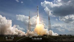
Third Lockheed Martin-Built GPS III satellite climbs to orbit on its own power
GPS III SV03 increases number of secure military code (M-code) enabled satellites in GPS constellation to 22 total.
After a successful launch on June 30, the third Lockheed Martin-built GPS III satellite headed to orbit under its own propulsion. The satellite separated from its rocket and used onboard power to climb to its operational orbit, approximately 12,550 miles above the Earth.
GPS III Space Vehicle 03 is responding to commands from U.S. Space Force and Lockheed Martin engineers in the Launch & Checkout Center at the company’s Denver facility. There, they declared rocket booster separation and satellite control about 90 minutes after the satellite’s June 30 launch aboard a SpaceX Falcon 9 rocket from Cape Canaveral Air Force Station, Florida.
“In the coming days, GPS III SV03’s onboard liquid apogee engines will continue to propel the satellite towards its operational orbit,” said Tonya Ladwig, Lockheed Martin’s acting vice president for Navigation Systems. “Once it arrives, we’ll send the satellite commands to deploy its solar arrays and antennas, and prepare the satellite for handover to Space Operations Command.”
After on-orbit testing, GPS III SV03 is expected to join the GPS constellation — including GPS III SV01 and SV02, which were declared operational in January and April — in providing positioning, navigation and timing signals for more than four billion military, civil and commercial users.
Lockheed Martin designed GPS III to help the Space Force modernize the GPS constellation with new technology and capabilities. The new GPS IIIs provide three times better accuracy and up to eight times improved anti-jamming capabilities over any previous GPS satellite. They also offer a new L1C civil signal, which is compatible with other international global navigation satellite systems, like Europe’s Galileo, to improve civilian user connectivity.
GPS III also continues the Space Force’s plan to field M-code, a more-secure, harder-to-jam and spoof GPS signal for our military forces. GPS III SV03 brings the number of M-code enabled satellites to 22 in the 31-satellite GPS constellation.
“As a nation, we use GPS signals every day — they time-stamp all our financial transactions, they make aviation safe, they make precision farming possible, and so much more,” added Ladwig. “GPS has become a critical part of our national infrastructure. In fact, the U.S. economic benefit of GPS is estimated to be over $300 billion per year and $1.4 trillion since its inception. Continued investment in modernizing GPS — updating technology, improving its capabilities — is well worth it.”
The Sagar Defence Spectre UAV. (Photo: Sagar Defence Engineering)
Altitude Angel, an unmanned traffic management (UTM) technology provider, is partnering with Mumbai-based Sagar Defence Engineering Ltd. in BVLOS trials supported by India’s Directorate General of Civil Aviation (DGCA).
Together, Altitude Angel and Sagar Defence have been selected by India’s DGCA to carry out beyond-visual-line-of-sight (BVLOS) drone operations. The results of the trials will help define India’s regulatory framework for unmanned aerial vehicles (UAVs) in routine UAV deployment.
Altitude Angel’s GuardianUTM platform will enable BVLOS drone flights around a multitude of real-life scenarios including medical and cargo delivery, surveillance operations, survey & mapping, and search & rescue operations.
The Union Government has recently begun the process of granting regulatory permissions to the operation of drones for commercial purposes.
On participating in the BVLOS trials Richard Ellis, Altitude Angel’s chief business officer, said, “The potential for UAV use in India is immense so we’re excited to be partnering with Sagar Defence on these BVLOS trials. The ability to fly safely and securely BVLOS will unlock the potential of drones not just in India, but across the world. With Sagar, we’re very much looking forward to showcasing our proven technology to demonstrate the amazing use-cases of drones.”
Mridul Babbar, Sagar Defence’s business development head added, “Sagar Defence Engineering and Altitude Angel, two highly skilled teams, coming together for the BVLOS trials is a very strong partnership and one we’re thrilled to be part of. The combination of our UAVs and Altitude Angel’s world leading UTM platform will undoubtedly help advance the prospects of BVLOS flight across India and beyond.”
The BVLOS trials are scheduled to take place from August through to October 2020.
The trials will further build on trials Altitude Angel has been involved in this year. The company served as the lead and umbrella UTM for the Lake Kivu Challenge, part of the African Drone Forum, which took place on the shores of Lake Kivu, Rwanda, in January.
NXP and Auterion join forces to enable next-generation secure drone fleets with automotive certified solutions, high-reliability networking, and a scalable and open software platform.
Working together, the companies aim to develop highly reliable and advanced hardware and software solutions deployable in an unmanned aerial vehicle.
With the development of regulations and the increasing number of autonomous systems in the field, the requirement for components and software that are certifiable and the ability to deploy intelligence on the edge is becoming more and more important.
NXP provides semiconductor components and expertise leading to certifiable electronics solutions, including computational horsepower, secure element for encryption and authentication, and high reliability automotive networking.
Auterion is offering the hardware reference design and Auterion Enterprise PX4, the software for the flight controller and the mission computer to make drone fleets safe and fully integrated into workflows. Auterion is the largest contributor to PX4 and builds its software platform on open standards, ensuring that enterprises have access to a managed and tested distribution of the open source technology.
The partnership addresses the needs of the unmanned aerial vehicles industry for compatible hardware and software solutions that will help drone manufactures bring state-of-the-art products to market. The aim is to ensure that manufacturers have a streamlined path to certification and are connected to existing workflows.
“This partnership will enable the mobile robotics community with the components meeting quality specifications needed to ensure functional safety and security in drones and rovers based on reliable long life industrial and automotive parts and reference designs,” said Iain Galloway, Drone Program Lead, Systems Innovation, NXP. “We have been participating in the open source PX4 community for several years now and with this close relationship with Auterion, and Auterion Enterprise PX4, we are excited to work together to ensure these vehicles are prepared to meet current and future regulations and standards governing modular safe drone architectures.”
“Safety is the number one priority in commercial drone operations. NXP’s leading position as a semiconductor provider for safety-critical automotive applications is the perfect pairing for Auterion’s enterprise-grade drone software platform,” said Lorenz Meier, co-founder and CEO, Auterion. “Together, we will be able to provide integrated hardware and software solutions to the drone industry that combine high-performance compute with safety-first engineering.”
NXP and Auterion will collaborate on the core hardware and software components of an autonomous system, this includes, but is not limited to, the following topics:
Developing the next generation Auterion Skynode avionics module reference design, based on the latest Pixhawk autopilot Reference Standards and on the NXP i.MX 8M Mini as a companion computer, and on future components in this family.
Integrating navigation modules incorporating NXP Ultra-Wideband (UWB), automotive MCU, NFC and authentication for precision landing applications.
Developing Battery Management System (BMS) solutions based on the latest Pixhawk Smart Battery Standards.
Developing Automotive CAN and CAN-FD node solutions supporting popular software protocols such as UAVCAN and MRCAN for mobile robotics peripherals.
Collaborate in the data cybersecurity and drone regulatory space to help shape and meet future regulations.
Both parties will continue to support the PX4 open source community and upstream PX4 development, in an effort to enable the whole industry.
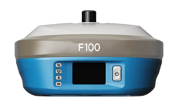
Geneq Inc.’s new F100 GNSS receiver, an upgrade to the F90, is designed to meet surveyors’ demands for high field performance, flexibility and cost-effectiveness.
The F100 tracks multiple constellations (GPS, GLONASS, Galileo, Beidou) and can maximize the acquisition and tracking process with all-in-view GNSS frequencies.
Another important feature from the F100 is the 1.45-inch color LCD display with a multi-touch capacitive screen. It has 32GB of internal memory. Its integrated second-generation web user interface control is compatible with all devices and all browsers.
Photo: Geneq
Providing maximum performance for accuracy and real-time measurements, F100 also supports real-time kinematic (RTK) correction services, including the RTX service that can get centimeter-level accuracy without a base station. The F100, with its advanced technology, ensures high performance even in difficult environments such as under heavy canopy.
The F100 has an excellent combination of GNSS, 4G, Bluetooth and Wi-Fi antenna. The innovative F100 has a built-in 5-watt radio that enables an effective baseline of 10 kilometers.
Its shorter charging time and a battery of 13600-mAh capacity enable long hours in the field. Even with its magnesium alloy casing, F100 weighs only 1.5 kg and measures 154 x 154 x 76 millimeters. Mobile field workers will find in this feature an ally to their surveying productivity.
With its integrated high-sensitive E-bubble and new tilt survey algorithm, the F100 becomes a calibration-free GNSS receiver. Immune to magnetic disturbance and free from limitation of tilt angles, the F100 can be used to measure unreachable points.
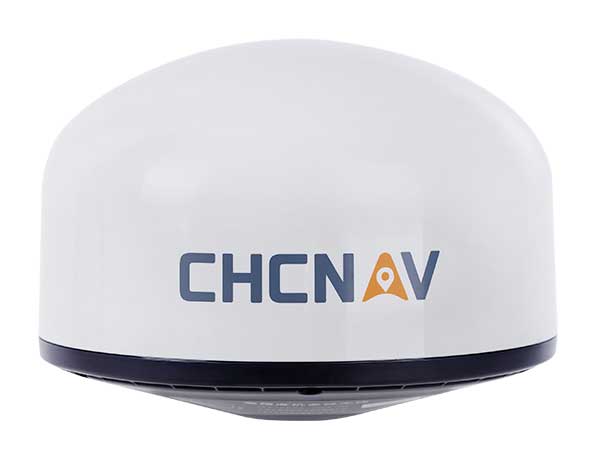
Designed for GNSS networks and monitoring applications
Photo: CHC Navigation
The AT661 geodetic antenna for GNSS networks or monitoring applications supports all current and future GNSS signals, including GPS, GLONASS, BeiDou, Galileo, QZSS, IRNSS, SBAS and L-band. The antenna features both high-gain LNA and wide beamwidth to provide excellent flexibility in applications requiring low-elevation satellite reception and high availability of GNSS signals, especially in obstructed situations. The accuracy of the antenna’s phase center reaches the millimeter level with extremely high stability and repeatability to ensure perfect processing of GNSS data regardless of the length of the baselines. The AT661 withstands all types of weather, including large temperature fluctuations, and is protected by a waterproof radome.
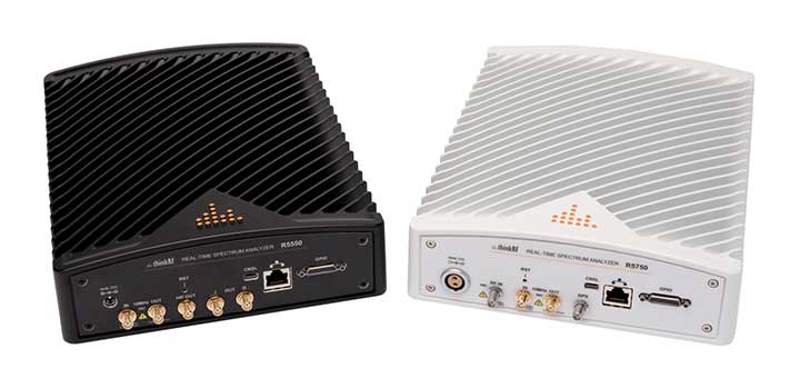
The ThinkRF R5750 Real-Time Spectrum Analyzer with GPS offers high spectral performance, low power consumption, and portability. The R5750 analyzer is built for outdoor, mobile and distributed deployment scenarios, including regulatory and intelligence monitoring, telecom deployment optimization, and RF application development. Users can deploy units in a variety of network architectures, analyze signals in real-time or later, and easily integrate with leading software applications to conduct demodulation or deeper analysis of signals up to 27 GHz. The R5750 analyzer includes embedded GPS for time and location data, and comes with an optional IP66 rating for increased durability and ruggedness in difficult environments.
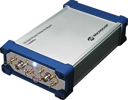
The 53100A Phase Noise Analyzer takes precise and accurate measurements of frequency signals, including those generated by atomic clocks and other high-performance frequency reference modules and subsystems. It combines timing technologies in a small, high-performance measurement instrument designed for engineers and scientists who rely on precise and accurate measurement of frequency signals generated for 5G networks, data centers, commercial and military aircraft systems, space vehicles, communication satellites and metrology applications. Up to three separate devices can be tested simultaneously using a single reference, enabling higher capacity for stability measurements.
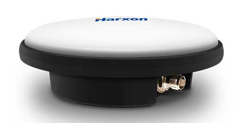
The IP69K ruggedized HX-CVX600A antenna provides end users with millimeter accuracy, durability and productivity. The antenna is designed for applications subject to high shock and vibration environments such as machine control. Integrated with reliable signal tracking and strong anti-interference performance, the Harxon HX-CVX600A offers full support for reliable and consistent satellite signal tracking, including GPS, GLONASS, Galileo, BeiDou, QZSS, IRNSS and SBAS, as well as L-band correction services. Its stable phase center adopts multipoint feeding technology, exceptional low-elevation satellite tracking with symmetric radiation patterns, high gain with ultra-low signal loss, as well as outstanding wide-angle circular polarization. The aerodynamic enclosure withstands exposure against dust, rain, splash or sunlight.
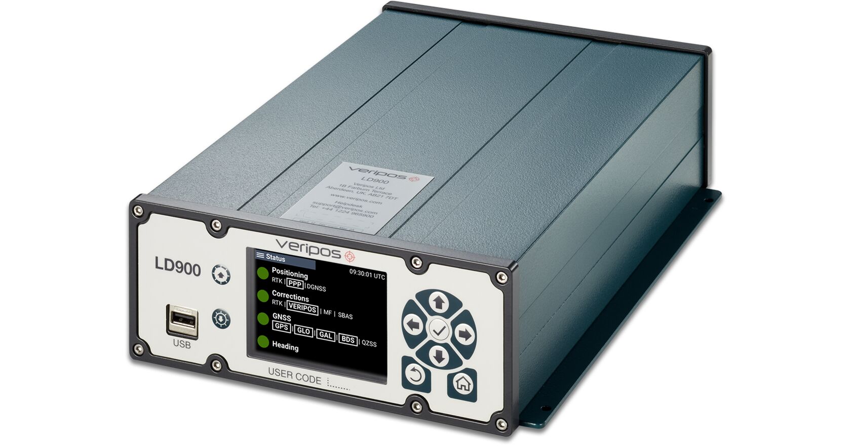
The LD900 is a quad-band GNSS receiver capable of tracking GPS, GLONASS, BeiDou, Galileo and QZSS constellations to provide reliable and accurate positioning. The LD900 also receives L-band signals on multiple channels, providing access to Veripos’ worldwide independent correction services. Using the independent L-band RF input on the LD900 allows the connection of a dedicated L-band antenna ensuring optimal reception of correction services, especially at high latitudes. Veripos provides accurate and reliable positioning for all marine applications via their redundant positioning and multi-frequency precise point positioning (PPP) Apex and Ultra services. The Apex5 correction service utilizes all GNSS constellations delivering 5cm positioning accuracy for use in the most demanding offshore applications. Real-time kinematic (RTK) corrections can be utilized by the LD900 for applications where this service is required. The intuitive color display and navigation menu makes setup, configuration and system status monitoring simple. The display also helps troubleshoot issues with the LD900, allowing faults to be quickly diagnosed and resolved. The LD900 can also be configured remotely through the Veripos Quantum software.
The edge-to-cloud IoT platform Particle is offering a new tracking system that allows organizations to track the locations of a wide variety of mobile assets. Particle’s Tracker system-on-module (SoM) provides a powerful GNSS, microcontroller and advanced peripherals in a compact form factor. Tracker SoM serves as a starting point for organizations that require a tailored tracking solution for sophisticated applications, as well as a fully certified foundation for OEMs developing commercial products. All of the company’s tracking solutions come with a high-gain GNSS antenna accurate to 1.8 meters. The field-ready solution is configurable and can track the real-time location of critical assets and capture additional intelligence via sensor data including temperature and acceleration as well as remotely controlled mobile equipment and vehicles.
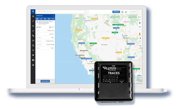
Designed in Europe, now available in North America
Photo: Ruptela
The Trace 5 plug-and-play GPS-based automatic vehicle location (AVL) tracker and multifunctional fleet management platform TrustTrack provide a ready-to-use telematics solution. The Trace 5 GPS tracker has LTE Cat M1 (4G) connectivity and an integrated battery. TrustTrack is an advanced telematics platform for businesses to manage transport resources. It connects dispatchers and drivers and enables real-time monitoring and drivers’ management. It also generates trip reports.
The HawkEye 5500 is the a dual-mode real-time tracking and vehicle management system that supports Iridium, GPS and 2G/3G/LTE. A GNSS/Iridium antenna is included in the kit. The HawkEye 5500 offers full integration of on-board systems, support for both light and heavy-duty vehicles, two-way messaging, a remote emergency switch, collision detection, audible alerts, RFID and Bluetooth driver identification and customizable application integration. It provides global always-on coverage with high-resolution tracking and communication. Users can customize reporting rates based on movement or location and provide driver feedback when safety violations occur. All operations are tracked via Blue Sky Network’s portal, SkyRouter, which allows for effective high-security command and control of fleets anywhere on the planet.
For infrastructure, mining, forestry, construction
Photo: Kaarta
The Stencil Pro, now in beta testing, is a professional-grade mobile mapping platform with dimensional and visual fidelity. The all-in-one system can scan, process and view captured data in real time. It offers panoramic high-definition 4K imagery and colorized point clouds, and is optimized for both indoor and outdoor lighting. Its simultaneous localization and mapping (SLAM) capabilities enable it to operate in GNSS-denied areas such as indoor, underground, under thick canopy, or in urban canyons. However, it is also fully geo-enabled with an integrated Trimble BD-990 receiver, AV-28 antenna and a range of other third-party GNSS antennas. It supports accuracy enhancements through live RTK/NTRIP processing as well as PPK corrections. GNSS positioning data is used to align and geo-register data for accuracy. The onboard GNSS and color cameras are fully integrated into real-time capture. If a colorized point cloud is not required, or GNSS is not available, reliance on other sensors is seamless.
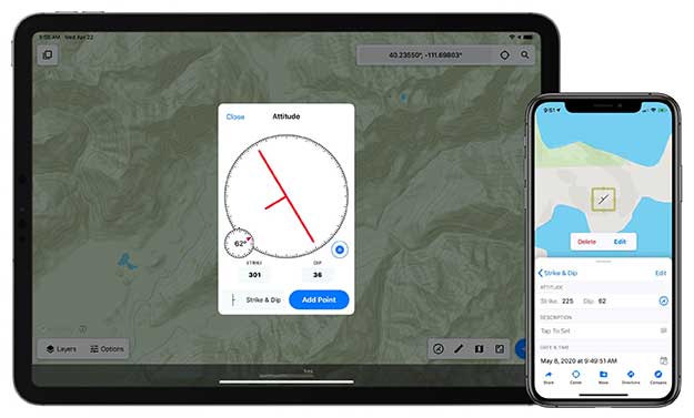
Touch GIS is a powerful mobile app for field data collection and visualization. Version 1.3 features a digital clinometer to assist field geologists in recording strike and dip readings as well as a new attitude attribute type, which makes it easy to record and display these readings on the map. Touch GIS has powerful file support for industry-standard types, offline mapping capabilities, and accurate drawing tools for points, lines and polygons.
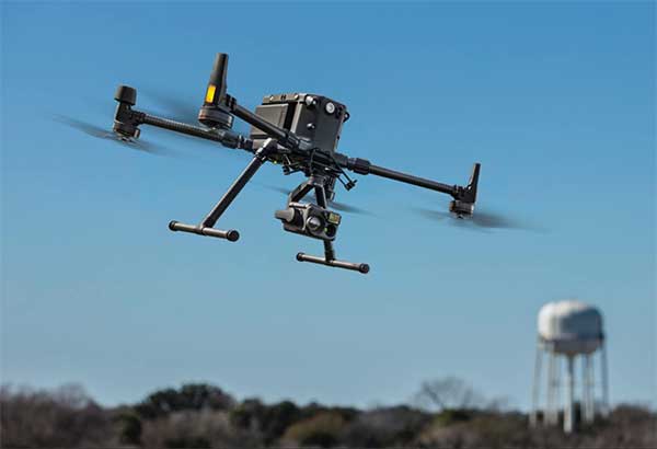
For precise aerial inspections and data collection
The Matrice 300 RTK UAV. (Photo: DJI)
The Matrice 300 RTK is DJI’s most advanced commercial drone platform to date. It integrates modern aviation features, advanced artificial intelligence capabilities, a six-directional sensing and positioning system and a UAV health management system. It has 55 minutes of flight time. The drone platform has AES-256 encryption and an IP45 weather-resistant enclosure. A built-in all-new OcuSync Enterprise transmission system provides a triple-channel 1080p video transmission signal reaching up to 15 kilometers away. The M300 RTK can support up to three payloads simultaneously and up to a total payload capability of 2.7 kg.
Robust positioning in demanding industrial environments
Photo: Septentrio
The AsteRx-i D UAS combines centimeter-level positioning with 3D orientation, enabling automated navigation of aerial drones and robots. It is compact and lightweight, with a high-performance inertial measurement unit from Analog Devices integrated directly into the receiver board. Its small form-factor combined with exceptionally low power consumption results in extended battery life and longer flight times. Both single-antenna and dual-antenna versions are available. The single-antenna version provides a lightweight solution optimizing the system size, weight and power (SWaP). The dual-antenna version is designed for machines that need reliable heading from the start.
“Seen & Heard” is a monthly feature of GPS World magazine, traveling the world to capture interesting and unusual news stories involving the GNSS/PNT industry.
Photo: Drazen Zigic/iStock/Getty Images/Getty Images Plus
Where’s the Beef?
A new mapping app is helping Los Angeles County residents find more than 2,000 food resources, during and after the COVID-19 pandemic. Sponsored by the non-profit 211 LA County, the LA FoodFinder is powered by Slingshot Earth, which aggregates food resources and service data from multiple public and private sources. The app enables residents to find resources for child nutrition, meal services, groceries/food pantries, senior food needs and government food benefits programs. Since the COVID-19 outbreak, 211 LA County has experienced a 10-fold increase in website traffic for food needs.
Photo: Symbiont/iStock/Getty Images Plus
Use that app in Germany? No Waze!
The German government has amended its road traffic regulations to outlaw apps that alert drivers to speed cameras. The law makes it clear that any app used for traffic-monitoring alerts is forbidden, whether it runs on a phone, tablet or a GPS navigation system. Violating the traffic laws and using speed camera apps inside a car could result in a fine of up to €75 (about $83). Both Garmin and TomTom have emailed registered users alerting them to the news.
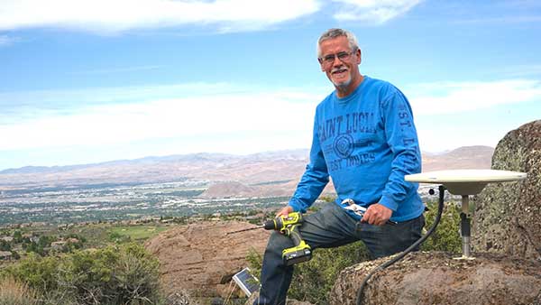
Photo: Geoffrey Blewitt/Debra Vigil
Making the most of GPS data
University of Nevada 2020 Outstanding Researcher Geoffrey Blewitt has made the most of GPS data to study changes in Earth’s crust, from the Ice Age to today. Nevada Today outlines his significant discoveries, including that GPS data may hold a key to detecting dark matter. Other discoveries: Nevada is the fastest growing state, geologically speaking, as it spreads apart. Drought in the western U.S. is causing the Sierra Nevada to lift, and the melting of ice sheets in Greenland is changing the shape of Earth.
Photo: iStock/Getty Images Plus/Getty Images
Koala care
Drones equipped with FLIR thermal-imaging cameras helped save koalas injured in this summer’s Australia bushfires. In a search-and-rescue operation, Victoria wildlife experts and police used DJI Mavic 2 Enterprise Dual drones to scan the forest for injured koalas, many found clinging to scorched eucalyptus trees. The images were relayed to a ground station in a nearby van for closer inspection. When a koala was located, the experts stepped in to assess the animal, and if needed, provide healthcare and relocate it. The team used cherry pickers to retrieve the little animals.
New patented PIC Inside technology is designed to enhance inertial sensor performance and reliability for the growing autonomous market
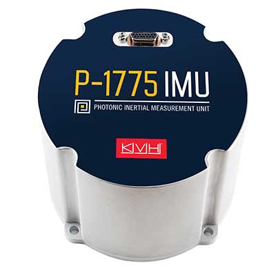
Photo: KVH
KVH Industries has launched the P-1775 inertial measurement unit (IMU), featuring KVH’s new PIC Inside photonic integrated chip (PIC) technology.
KVH has been developing and testing the technology for more than three years and is now incorporating it into existing product lines. The first units have started shipping.
One of the first customers has integrated the P-1775 IMU into its next-generation rocket launch vehicle.
KVH’s PIC Inside technology features an integrated planar optical chip that replaces individual fiber-optic components to simplify production while maintaining or improving accuracy and performance.
The PIC Inside product is designed to deliver 20 times higher accuracy than less expensive MEMS inertial measurement units, uses modular designs for ease of integration, and has outstanding repeatability unit-to-unit.
“I applaud the tremendous effort by our incredible engineers in developing this groundbreaking technology and I am thrilled that we have begun to incorporate PIC Inside technology into our existing products, a process that we expect to continue throughout the year,” said Martin Kits van Heyningen, KVH CEO.
The PIC technology will be added to KVH’s inertial sensor product line for use across a broad range of applications from navigation to stabilization and pointing. KVH’s fiber-optic gyros (FOGs) and FOG-based products are particularly well-suited for the large and growing autonomous market. This market includes applications on land, sea and air, such as drones, people movers, trucks, and mining and construction equipment.
Autonomous applications rely on high-quality inertial sensors to deliver an extremely accurate navigation solution, delivering the performance required in critical metrics such as angle random walk (ARW) and bias instability.
Next-generation driverless cars, which require centimeter-level precision for safety, are the ideal application for KVH’s inertial products, KVH said. Employing the PIC design allows for a lower cost and scalable solution due to the elimination of various fiber components and a reduction of labor.
In 2019, KVH delivered its first product prototypes containing PIC technology to automotive customers and presented the science behind the technology to an audience of engineers at an inertial sensor conference, describing the extensive development, testing, and benefits of the new technology.
KVH is a leading innovator for assured navigation and autonomous accuracy using high-performance sensors and integrated inertial systems. KVH’s widely fielded TACNAV systems are in use by the U.S. Army and Marine Corps as well as many allied militaries around the world. KVH’s FOGs and FOG-based IMUs are in use today in a wide variety of applications ranging from optical, antenna and sensor stabilization systems to mobile mapping solutions and autonomous platforms and cars.
On June 26, the U.S. National Oceanic and Atmospheric Administration (NOAA) released the summary of the results of Commercial Weather Data Pilot (CWDP) Round 2. View the summary here.
In Round 2, NOAA evaluated GNSS radio occultation data from two U.S. commercial space companies: GeoOptics and Spire. NOAA concludes that, based on the results of CWDP Round 2, the commercial sector is able to provide radio occultation data that can support NOAA’s operational products and services.
“As a result, NOAA is proceeding with plans to acquire commercial RO data for operational use,” the summary states.
According to GeoOptics, the report highlights the unique qualities of its commercial GNSS-RO data and its ability to improve weather and space weather forecasts around the world.
“As today’s report demonstrates, commercial satellite data will enable NOAA to make significant improvements in forecasting worldwide within the consistent budget limitations under which it operates,” said GeoOptics CEO Conrad Lautenbacher.
NOAA anticipates release of a request for proposals soon for operational purchase of commercial radio occultation data, continuing an acquisition process that began in April with NOAA’s release of a draft Statement of Work.
NOAA has requested $15 million in FY 2021 to support Commercial Data Purchase. The FY 2021 Budget also requests $8 million for CWDP to investigate new commercial technologies beyond radio occultation.
By moving into this next phase of engagement with U.S. industry, NOAA is leveraging commercial space sector capabilities to support its operational products and services and to continue to improve its weather forecasting capabilities. NOAA plans to implement additional rounds of the CWDP to evaluate commercial capabilities beyond radio occultation data for potential operational use.