SBG Systems renews its popular line of miniature inertial sensors with high-end functionalities and dual frequency RTK
SBG Systems has announced the third generation of its Ellipse series of miniature inertial sensors. The renewed product line benefits from a 64-bit architecture, allowing high precision signal processing.
All of the INS/GNSS devices now embed a dual-frequency, quad constellations GNSS receiver for centimetric position and higher orientation accuracy.
SBG Systems manufactures miniature high-accuracy inertial navigation systems with inertial measurement unit (IMU) design, calibration and filtering. All improvements made in the high-end lines could naturally benefit the Ellipse miniature line.
The Ellipse series includes four models.
Ellipse-A is a motion sensor
Ellipse-E provides navigation with an external GNSS receiver
Ellipse-N is a single-antenna RTK GNSS/INS
Ellipse-D is a dual-antenna RTK GNSS/INS
With its new 64-bit architecture, the third-generation Ellipse series enables the use of high-precision algorithms and technology used in high-end inertial systems such as rejection filters and FIR filtering.
All Ellipse miniature INS are now RTK-enabled without extra cost, and output raw data for post-processing. All these features are made possible in a small, robust aluminum-enclosure box version, as well as in the 17-gram OEM version.
The 17-gram OEM version of the Ellipse-D can provide drones with high-end features. Its dual antennas gives UAVs robust instant heading for take-off. Dual antenna is achievable with a very short baseline, down to 50 centimeters. Integration is enabled with ROS and PX4 drivers, full API, and free phone and email technical support.
Ellipse-D
Ellipse-D is the smallest dual-frequency, dual-antenna RTK GNSS/INS device offered.
With its dual-frequency RTK GNSS receiver, the Ellipse-D provides a centimeter positioning. Dual frequency provides more robust heading and position computation than single-frequency receivers. It also allows high performance in attitude (0.05°) and in heading (0.2°).
With its dual-antenna capability, Ellipse-D provides precise heading in a few seconds, in all dynamic conditions, and even in challenging GNSS conditions. It is also immune to magnetic disturbances. Ellipse-D is a quad-constellation receiver, simultaneously using signals from GPS, GLONASS, BeiDou and Galileo to enable navigation in challenging conditions.
Designed with high quality industrial-grade components, Ellipse inertial sensors are highly tested and calibrated in dynamic and temperature for consistent, repeatable behavior in all conditions.
Septentrio has unveiled the AsteRx-m2 Sx OEM board, which provides a GPS/GNSS receiver with always-on sub-decimeter accuracy without the need for additional correction service subscriptions.
With the AsteRx-m2 Sx, Septentrio is pioneering a novel approach to high-accuracy positioning. Its latest core GNSS technology is integrated with a sub-decimeter correction service enabling simple plug-and-play positioning solutions.
High-accuracy positioning is available directly out of the box as GNSS corrections are automatically streamed to the receiver. This significantly simplifies the receiver set-up process and eliminates the hassle of corrections service subscription and maintenance.
“This product marks a new step for GNSS technology towards convenience and ease-of-use,” said Danilo Sabbatini, product manager at Septentrio. “By integrating the correction service directly into the GNSS receiver, we are removing the hassle of positioning service set-up and maintenance from the user. This means faster set-up times for our customers and worry-free, always-on high-accuracy positioning throughout the receiver lifetime.”
The AsteRx-m2 Sx is an efficient positioning solution for small robots, aerial drones and automation applications. Its optimized size, weight and power (SWaP) means longer operation on a single battery charge and better value in the field, according to Septentrio.
Advanced anti-jamming technology AIM+ ensures robust and reliable operation in challenging environments, even in the presence of RF interference.
Septentrio is offering a free GNSS corrections webinar on July 8 at 5 p.m. CEST/ 8 p.m. PST.
The webinar, sponsored by Nearmap, takes place June 25 at 1 p.m. EDT / 10 a.m. PDT / 7 p.m. (1900h) Central European Time. Registration is free.
Managing and protecting the nearly 31,000 acres of the preserves is no small task, so the ability to see the environment at scale in crystal-clear clarity is a must. Aerial imagery provides an “eye in the sky” to get better context of truth on the ground.
Lake County Forest Preserves uses Nearmap aerial imagery to:
monitor and track change over time with historical and current captures
assess and address invasive species growth with high-resolution imagery
manage remote work challenges during COVID-19 to locate assets.
Joining Brett Clark of Nearmap are three experts from Lake County Forest Preserves.
Nick Spittlemeister GIS Analyst, Planning and Land Preservation Dept. Lake County Forest Preserves District (IL)
Nick Spittlemeister has been with Lake County Forest Preserves since 2016, working to create an enterprise solution that employs web GIS in all facets of the organization. He helped the district secure a license with Nearmap in 2018 and has deployed it across their GIS system, from Desktop software to web applications and native apps. He has been using GIS for more than 15 years and holds a bachelor’s degree in geography from Northern Michigan University.
Dave Cassin Manager of Landscape Ecology Lake County Forest Preserves District (IL)
David Cassin’s remote sensing training began in the US Navy (1990-94) where he was trained as an Intelligence Specialist / Air Photo Interpreter, put into practice during Operation Desert Shield / Storm. Post military service, he continued his craft in college with incorporation of ArcGIS. He combined his skillset and his love of nature by getting a degree in Natural Resource Management. Integrating remote sensing skills into landscape scale restoration projects by utilizing historical air photos and land survey data, he is able to determine historic land uses and alterations. Specific to Nearmap, he was able to map populations of Phragmites australis (an invasive species in Illinois) by utilizing the fall 2019 Nearmap imagery remotely during the COVID-19 stay at home order.
Kevin Kleinjan Senior Engineer Lake County Forest Preserves District (IL)
Kevin has utilized aerial imagery and geospatial technologies for over 25 years to inform and support planning and infrastructure related decisions. He utilizes Nearmap’s high-resolution imagery with multiple captures throughout a calendar year to analyze and update infrastructure assets quickly and accurately from both the office, and in the field using mobile devices. This enables him to efficiently manage the District’s sign shop, site amenity and heavy equipment crews. He has dual degree in Landscape Architecture and Geography from South Dakota State University and is a Registered Landscape Architect in Illinois and Wisconsin.
Brett Clark Senior Account Executive Nearmap Brett graduated from Brigham Young University with a degree in communications. He was employee #2 for Nearmap, U.S., and focuses primarily on serving the public sector – both state and local. Brett lives in the Indianapolis area with his wife and three daughters.
HoverGames Challenge 2: Help Drones Help Others is the second installment of NXP’s challenge-based, interactive coding competition. It encourages developers to create drone and rover solutions for frontline support during pandemics.
A carbon-fiber quadcopter frame is included in the developer’s kit. (Photo: NXP)
Participants will leverage NXP’s broad portfolio of automotive, industrial and IoT technologies for system control, networking, security and motor control to create solutions that can make a difference in pandemic response.
The first HoverGames took place in the summer of 2019, and was centered around firefighter response. Read about it here.
The collateral effects of pandemics leave citizens with difficult challenges to overcome. A lack of mobility, social isolation and lack of access to goods and services can be physically and psychologically devastating.
HoverGames Challenge 2 will inspire participants to develop pioneering ways to use drones to help healthcare and frontline workers overcome these barriers. The competition encourages contestants to consider the full scope of the difficulties facing society during a pandemic, apply new learning, and work cooperatively through the development of open-source code and community-tested projects to create solutions that help society prepare for future challenges.
Deadline for application is July 31. The competition closes Nov. 30, and winners will be announced in December.
Drone Developer Kit. The hardware and software of this year’s developer kit remains open, flexible and modular. The flight management unit (RDDRONE-FMUK44FMU) includes professional, automotive and industrial-grade components enabled by the PX4 flight stack. PX4 is a large commercially deployed open source flight stack and supports contemporary airframe architectures including vertical-takeoff-and-landing (VTOL) aircraft, multicopter and rover profile.
The kit also includes a strong, rigid, lightweight carbon-fiber quadcopter frame with platform, mounting rails, landing gear, motor controllers, motors and props as well as telemetry radio and remote-control radio.
This year’s kit will contain a bonus extension component, the NavQ, an i.MX8M Mini Vision development board.
Projects and lessons learned are transferable to real-world enterprise and commercial applications thanks to Auterion, the company that builds the enterprise distribution of PX4 for the commercial drone market.
“The current pandemic has exposed our vulnerability to disease and the general structural breakdown that can occur during a crisis,” said Iain Galloway, drone program lead, Systems Innovation, NXP. “But we don’t have to feel powerless in its wake. We can harness technology to make a difference. We invite you to leverage a complete functional system of hardware and software for drone and rover development and to share your creative solutions.”
The F-110 frigate being developed for the Spanish Navy. (Artist’s concept: Spanish Ministry of Defense)
The technology multinational GMV has signed a contract with Spanish corporation Navantia to develop and supply its SENDA navigation system for the future F-110 frigates.
The F-110 frigates represent a technological leap forward in platform systems and its combat system, incorporating Industry 4.0 technologies to improve lifecycle-long system management.
The various F-110 systems call for a continuous, precise, and trustworthy positioning, speed and attitude source. With this purpose in mind, SENDA incorporates multi-constellation (GPS and Galileo) satellite navigation technology compatible with both civil and military signals, plus differential GNSS corrections. It combines its GNSS navigation data with data received from external sensors, such as inertial navigation systems (INS) and pitometer logs. It includes state-of-the-art algorithms to provide robust navigation in contested GNSS scenarios.
SENDA also includes a timing server that generates highly precise and stable timing signals, allowing the ship’s systems to synchronize with GPS time. SENDA guarantees timing-reference stability and negligible drift, even during prolonged periods of GPS downtime.
SENDA is a redundant system with two complete functional subsystems working in active-active configuration, together with redundant GNSS signal distribution. Both systems, monitored in real time, exchange information to provide the overall system with the best possible solution.
GMV has experience in aeronautics, land and naval sectors with platforms such as the Atlante tactical long-endurance UAV, the 8×8 Dragon ground vehicle and now the F-110 frigates.
GMV worked with the Spanish Ministry of Defense MoD to develop a system prototype during the F-110 definition phase. The future F-110 frigates will replace the current Santa María class frigates starting in 2026.
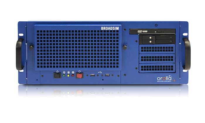
The U.S. military selected Orolia Defense and Security to supply multiple BroadSim advanced GPS simulator systems, a contract valued at $1.7 million (USD), in an effort to upgrade testing facilities and field test assets.
The BroadSim Advanced GNSS Simulator (Photo: Orolia)
These new simulator systems will enable better testing of widely deployed military GPS receivers, which are integrated into air and ground-based positioning, navigation and timing (PNT) systems.
BroadSim will be leveraged with Orolia’s Panacea test suite, which the U.S. military uses to conduct automated testing and analysis for PNT system performance and vulnerabilities.
BroadSim will bring versatility to the testing process by supporting diverse test methods and environments such as a laboratory setting, or an over-the-air (OTA) field test event.
BroadSim was selected based on its flexibility to support the ever-changing military tasks at hand, according to Orolia. It can be easily configured to support laboratory testing one day, and field testing the next with its four independent RF outputs, removable drives, and software-defined architecture.
“Equipping our actively deployed warfighters with state-of-the-art technology is of utmost importance and can mean the difference between mission success and failure. To help achieve that goal, Orolia’s GPS testing and simulation solutions ensure that these systems are battlefield ready,” said Tyler Hohman, Orolia Defense and Security’s director of products.
Orolia will host a webinar on this topic on Thursday, July 16, at 2 p.m. EDT, titled “PNT Vulnerability Testing for Critical Infrastructure:Lessons Learned from Defense.”
The federal government considers PNT to be a critical aspect of mission success, as outlined in the C4ISRNET white paper “Protecting the U.S. Military PNT Advantage from GPS Jamming and Spoofing” and defined in the PNT Executive Order. For the 2021 federal fiscal year, the U.S. Army alone budgeted more than $275 million towards Assured PNT Research, Development, Test & Evaluation (RDT&E), as published in the 2021 Defense Budget.
The huge current investment in deploying 5G mobile networks is promoted by setting high expectations for significantly increased throughput and reduced latency.
This can only be realized by deploying the network radios close to the users, especially for the millimeter-wave frequencies with their short propagation distance.
This also means a high density of radios, often imbedded within macro coverage.
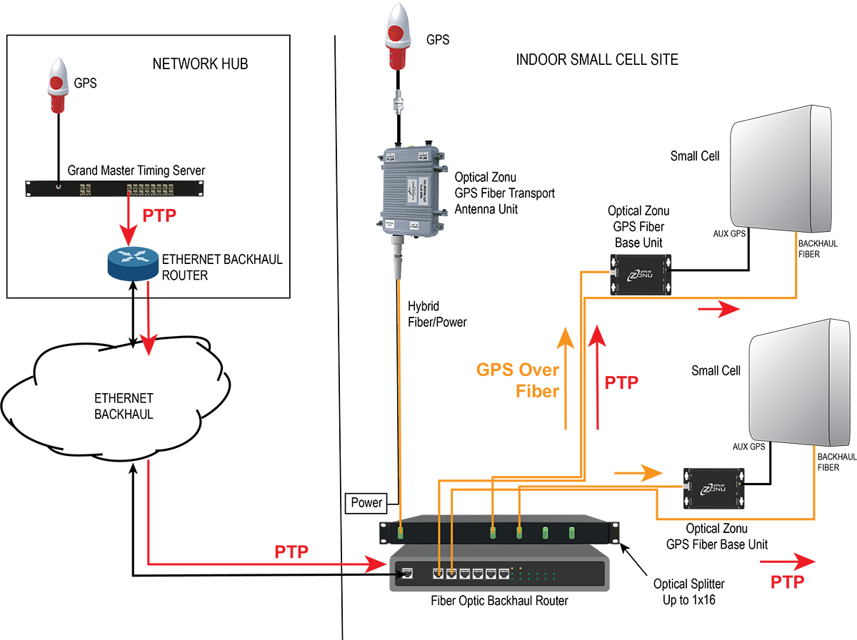
To coordinate seamless functioning, network synchronization accuracy must be much higher than with legacy deployments, according to Optical Zonu. The greatly enhanced data throughput with advanced features such as aggregation, massive multiple-input/multiple-output (MIMO) and beam steering require highly accurate network timing and phase coordination.
Small cells close to a network’s edge are usually far from the hub where the grandmaster timing server generates the PTP timing signal and sends it to the network edge over the Ethernet backhaul. The long runs require multiple hops through routers and switches. Each of these adds dynamically changing packet delays depending on network loading. Also, there are inevitable asymmetries between the upstream and downstream packet delays. These timing errors can result in a drastically reduced network performance.
One way to correct these timing errors is to connect an edge grandmaster server at the small cell location connected to the local backhaul router. Connecting the GPS directly to each of the small cells is the other way.
The GPS approach is simple in concept, but has been problematic since, with small cells distributed in the facility, many or all the units can be far from a window where a GPS antenna could be mounted.
Optical Zonu, a U.S. carrier-approved supplier of RF-over-fiber transport solutions, has solved this problem with its GPS at the Edge kit. The GPS-over-fiber solution distributes GPS to each small-cell location alongside the backhaul.
A compact GPS fiber antenna unit connects to a GPS antenna on the roof. A single cable connection to this unit provides power to the unit and brings the fiber-optic connection to an optical splitter, which is collocated with the local router for the small-cell backhaul.
The fibers from this splitter are routed along with the backhaul cable to each small-cell location, where they each connect to a small fiber base unit that recovers the GPS signal and connects it to the auxiliary GPS port on each small cell.
Optical Zonu offers two variants.
Small cells with fiber-optic backhaul. Higher power cells typically use a fiber-optic backhaul and require local AC power. In this case, one of the fibers in the cable to each small cell is used for the GPS connection, and each base unit connects to the local AC power with an adapter. In this case, the only additional cable needed is the single run to the rooftop.
Diagram: Optical Zonu
Small cells with a CATx backhaul. This setup is typical for lower power small cells. In this architecture, a single fiber is pulled along with the CAT6 backhaul cable. A single hybrid fiber/CAT6 cable can also be used. The fiber is connected to a small fiber base unit at each small cell to recover the GPS signal, which is connected to the small cell auxiliary GPS port. The CAT6 is also connected to the fiber base unit. The backhaul is passed through from the small cell, and the PoE++ is tapped to power the base unit. Once again, the only additional cable pull is the single run to the rooftop antenna — local power isn’t needed at every small cell location.
Diagram: Optical Zonu
The Optical Zonu GPS at the Edge kit provides an easy-to-install and cost-effective solution that guarantees the highest timing and phase accuracy for a network that is vendor agnostic and, as with the edge grandmaster approach, still has the central PTP as a backup.
Australia-based Position Partners has launched MiRTK, an open architecture corrections service for GNSS equipment.
Internet-enabled, MiRTK offers an alternative to UHF radio correction services for high-accuracy GNSS. Unlike UHF radios, MiRTK is not limited by range from the GNSS base station and does not require line of sight with the survey rover or machine.
MiRTK uses a small modem that slides onto the accessory slot of the tripod and connects to the base station via a single cable.
A subscription service is available in locations with the Telstra network, mainly continental Australia.
MiRTK is designed for accurate GNSS positioning in the construction, mining and geospatial industries. It is compatible with all brands and models of GNSS from manufacturers including Topcon, Trimble, Leica Geosystems, Sokkia, Hemisphere and more.
“Until now, users that rely on high-precision GNSS for applications such as surveying and machine control had no option but to use UHF radios or a network RTK solution,” said Cameron Waters, geospatial business manager at Position Partners.
“Anyone that’s had to rely on UHF radio frequencies will have experienced problems, including interference, range limitations, costly licensing and severe penalties for breaching licensing laws. MiRTK offers an alternative that is refreshingly simple: no repeaters, no line of sight issues and no complex licensing,” he added.
The Galaxy lithium mine in Ravensthorpe, Western Australia. (Photo: jasonbennee/iStock / Getty Images Plus/Getty Images)
Another benefit, according to Waters, is the ability to utilise a single correction protocol across all GNSS equipment on site. This dramatically reduces complexity and potential connectivity issues. “MiRTK uses NTRIP and a user selectable format such as RTCM3 or CMR, that can be used universally regardless of the brand or model of equipment,” he said. “Users enjoy full speed, full constellation connectivity without the complex radio settings, baud rates, bandwidth or scrambling problems that you get when trying to utilize different GNSS systems with UHF radios.”
To set up the unit, users simply connect the modem to the base station, power the modem on and MiRTK will work for up to 20 hours continuously without charge. Each unit can connect with up to 10 devices such as survey rovers or machine systems as standard, with unlimited potential to scale up connections as required.
“The future of UHF is limited with lower bandwidth, higher density areas, increased governance, rising costs and little flexibility,” Waters said. “MiRTK gives customers a new approach to receive reliable correction data in a simple and hassle-free way, whilst utilizing their existing GNSS hardware.”
Reaching ’round the world: GPS World staff engage in a teleconference with Editorial Advisory Board members and contributors via teleconferencing. Clockwise from top: Tim Burch, John Fischer, Mitch Narins, William Tewelow, Julian Thomas, Jean-Marie Sleewaegen, Thibault Bonnevie, Ismael Colomina, Michael Swiek, Tony Murfin, Miguel Amor, Alison Brown, Ellen Hall, Brad Parkinson, Stuart Riley, Greg Turetzky, Tracy Cozzens and Matteo Luccio. (Photos: GPS World)
Our readers participated in an online survey on how they are being impacted by and responding to the COVID-19 pandemic. We summarize your responses here.
In April, GPS World asked its readers how the COVID-19 pandemic is affecting the GNSS/PNT industry and their day-to-day work.
About three quarters of respondents fell into two general areas of work: commercial (43%) and government/civilian (33%).
The three biggest market sectors primarily served by respondents’ companies are survey and construction (28%), defense and government (20%), and mapping and geographic information systems, or GIS (14%).
Because of the critical need for mapping during the pandemic, almost all mapping and GIS respondents said they have adapted to answer the needs of those seeking information about the coronavirus pandemic.
Supporting Solutions
About 14% of respondents reported their company has provided products or services for an application, project or customer directly tied to a COVID-19 response. These include support for police and government supervision, government and federal agencies’ emergency vehicles, air transportation, as well as medical supply transport.
Other efforts include ramping up the manufacturing of personal protective equipment such as face shields, with plants repurposed; others donated face masks, disinfectant and money. Also playing a supporting role are IT- and statistic-related services.
Tracking COVID-19. GNSS services provided by our readers to help track the virus include helping multiple agencies monitor traffic to and from critical locations, and building online dashboards for state data and surveillance.
“Our ability to provide GPS network services has enhanced the ability of public- and private-sector surveyors to continue working, to stay employed during these difficult economic times,” said one respondent.
Roadblocks. During the coronavirus pandemic, only 14% said they are significantly challenged to access parts and services, while 41% noticed a slowdown in deliveries. Comments included: “There have been issues getting supplies to set up for telework” and “Some international suppliers are having issues, so we are looking into alternative suppliers.”
Glass Half-Full
While there’s no question the COVID-19 outbreak has presented challenges, many respondents shared positive experiences while working in this current environment.
Working Remotely. For many of us, learning how to work remotely has been a positive experience, providing options that were overlooked or not considered before. Many readers were pleasantly surprised by how easy the transition has been and how well it has worked.
“It’s been a smooth transition to telework and production continues at normal rates,” said one respondent.
Others reflected on their successful adaptability with remote working, with comments such as “We have proven we can function with staff working remotely,” and “It brings people together in new ways!”
“As the team manager, I was fortunate that I had been transitioning my staff to be flexible in their work locations by replacing their desktop computers with notebook computers, enforcing the utilization of shared network resources for project data, and making sure IT systems were working for them — at work, in the field, and at home — prior to the pandemic. This has given me confidence in part-time telework for this group.”
Employees have become “more focused and more productive in necessary areas: documentation, contracts and gaining necessary certifications and contract information.”
Working from home also has improved productivity with fewer meetings and no commuting. “Traffic in any case was horrific.”
Rise of the Machines. Other respondents looked even further to the future. “COVID-19 has given companies and people a wake-up call. The new economy and new dynamics of workforce management will never be the same. This will help us tremendously as we approach AI (artificial intelligence) automation.”
No More Backlogs. While work has slowed in many areas, that cloud can have a silver lining. “It has allowed a backlog of work to be caught up, but we expect that will be temporary as business begins to bounce back.”
Finally, some respondents noted the human factor coming to the fore, including improved hygiene, seeing people help each other, and “more compassion for people in general.”
Photo: Photo: ftwitty / E+ / Getty Images
Where Do We Go from Here?
We asked our readers if coronavirus pandemic-related workflow changes and adaptations have brought about innovations they intend to keep going forward.
Many readers commented that increased reliance on working at home and new digital workflows will continue past the end of the pandemic. Online communication tools cited include email, WhatsApp, Skype, Teams and Zoom. “Knowledge and use of these tools are now ubiquitous,” wrote one respondent.
Others commented that traveling for meetings will be less frequent and reliance on videoconferencing will increase.
Staying Home. Companies plan to continue with at least some staff working from home to reduce their office-space spending. “I will probably have my staff telework two days per week once this pandemic passes. We will have more online training modules prepared. Digital signatures will be the norm.”
Senior Editor Tracy Cozzens Zooms from her home. (Photo: Steve Cozzens)
One respondent wrote, “We intend to keep using the digital workflow. Accepting and returning PDF plat reviews has worked very smoothly.”
“We are redesigning the logistics of how our business operates — decentralized versus centralized. In this new landscape, businesses cannot be tied to one central location,” another reader wrote.
Others are taking part of the new workflow back to the office: “Videoconferencing has taken on a new light. It works well, and will continue even after we move back to the office.”
Some had a steeper adaptation curve: “As a state government agency, we were not prepared to have the majority of staff working remotely, so we have had significant IT issues.”
Staying Healthy. “We will increase cleaning and sanitizing routines, and all employees and guests will have their temperatures taken before entering, and while on property,” commented one reader.
“The world has changed, and how these changes will affect our business has yet to be determined.”
A Look at Surveying
Surveying companies have adopted remote-office connection strategies and new ways to exchange digital and physical information with their field crews.
About two thirds of professional surveyors have taken steps such as working remotely and videoconferencing to collaborate with colleagues and clients. One respondent said, “We quickly pivoted to working from home by utilizing WebEx and Google Hangouts for collaboration.”
Out in the Field. Some firms are limiting one person per vehicle when traveling to work sites. “Drafting is done via work-from-home on laptops.” Field crews now typically are a single person using GPS and communicating via email.
Going Digital. “The paperless agenda that was difficult to institute is now in place and operational,” commented one surveyor. “It’s often difficult to change until we get that nudge.”
Two F-16 Fighting Falcons fly over Edwards AFB during a 2009 air show. (Photo: U.S. Air Force/Chad Bellay)
The U.S. Air Force in September will begin testing on F-16’s an alternative position, navigation and timing (PNT) solution that uses the Earth’s magnetic anomalies.
The navigation technique, dubbed MAGNAV, is being researched at the Air Force Institute of Technology (AFIT), reports Forbes.
Air Force Major Aaron J. Canciani, an Assistant Professor of Electrical Engineering at AFIT, designed algorithms for MAGNAV flight testing on F-16s. Testing has already taken place using private survey aircraft.
MAGNAV sensors and software will be flown on Air Force Test Pilot School (AFTPS) F-16s over a special test range adjacent to Edwards Air Force Base in Nevada.
Magnetic anomaly navigation uses scalar magnetometer sensors that measure differences in the magnitude of magnetic fields when traveling past them. These variations can be compared with known features in magnetic field maps and be interpreted to determine position.
The four pillars of MAGNAV are magnetic maps, sensors, algorithms and calibration. The magnetic maps already exist within industry, the military and government agencies including NOAA, NASA, NGA and more.
NOAA’s EMAG2 (v3) World Digital Magnetic Anomaly Map. (Image: NOAA National Geophysical Data Center)
Jackson Labs Technologies (JTL) has launched the PNT-6220 Assured Reference — a product combining low-Earth-orbit (LEO) signals, GNSS, terrestrial, wireline and atomic clock services in one small solution, specifically designed for critical infrastructure applications.
The PNT-6220 reference seamlessly combines concurrent L1, L2, L3 and L5 GNSS reception with a custom JLT-designed LEO-based Satellite Time and Location (STL) timing receiver. It also includes terrestrial receivers and PTP/IEEE-1588 edge grandmaster (EGM) and PTP/IEEE-1588-slave capability.
The PNT-6220 provides assured PNT for critical infrastructure applications such as those described in the directives of Presidential Executive Order 13905.
It can serve as a timing reference for 5G equipment, an ePRTC-capable reference, or a high-performance disciplined reference that supports PTP/IEEE-1588, STL, RF distribution and multi-frequency GNSS capability.
The PNT-6220 will be able to select the most optimal UTC reference input automatically and auto-switchover among its numerous reference inputs if one or more of them are jammed or spoofed, as well as average several references for additional stability and accuracy.
If all external references are jammed, the unit can provide UTC timing from its internal holdover oscillator with options that have less than 100-ns drift over 24 hours. The unit is also capable of outputting a GPS RF distribution signal driven by the internal flywheel oscillator, which allows glue-less retrofitting of any GPS-based legacy user equipment to the state-of-the-art reference sources the PNT-6220 can receive by simply plugging into the legacy equipment GPS antenna input.
Available Options
Numerous options are available for the half-width 19-inch-wide rack-mount box.
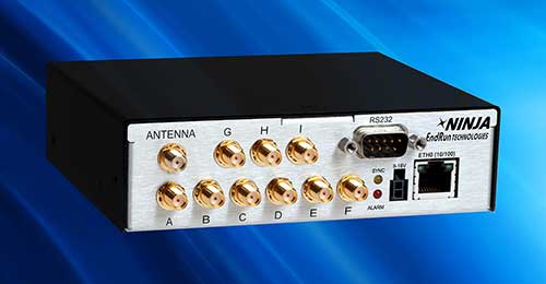
New GPS-synchronized Ninja Precision Timing Module provides a myriad of time and frequency outputs with high performance in a small, low-power platform.
Photo: EndRun
EndRun Technologies, a provider of precision time and frequency solutions, has released the high-performance Ninja Precision Timing Module (PTM). The third-generation Ninja — optimized for size, weight and power (SWaP) — can be easily integrated into 1U host systems or deployed as a cost-effective standalone solution.
The resilient GPS-synchronized Ninja is based on the core of EndRun’s Meridian II Precision TimeBase instrument. Up to nine optional, user configurable, time and frequency outputs are available with accuracy, stability and ultra-low phase noise. Ninja’s network interface includes a robust Network Time Protocol (NTP) server as well as secure management.
Three OCXO reference oscillators are available to meet price-performance requirements. Advanced users can optimize Ninja with EndRun’s innovative Real-Time Ionospheric Corrections (RTIC) to directly measure and compensate for ionospheric delay of received GPS signals in real-time.
“The Ninja Precision Timing Module is another breakthrough solution from EndRun that provides an abundance of outputs in a small form factor without compromising performance,” said Michael Korreng, senior R&D engineer, EndRun Technologies. “The high-level of integration and output versatility readily integrates into many mission critical applications including SATCOM, tactical communications, signal intelligence, security camera synchronization, digital broadcast, network synchronization, range timing, and many more.”
Key Ninja performance specifications with Ultra-Stable OCXO, Real-Time Ionospheric Corrections, and calibration are:
Time accuracy of <10 nanoseconds RMS to UTC(USNO)
Frequency accuracy better than 4×10-14 (100k second average)


 Nick Spittlemeister
 Dave Cassin
 Kevin Kleinjan