Author: Tracy Cozzens

  • SMC and SpaceX launch third GPS III satellite

    SMC and SpaceX launch third GPS III satellite

    Update (U.S. Space Force news release): The U.S. Space Force and its mission partners successfully launched the third GPS III satellite at 4:10 p.m. EDT June 30 from Space Launch Complex 40 at Cape Canaveral Air Force Station, Florida. The Lockheed Martin-built satellite was carried to orbit aboard a Space Exploration Technologies Corporation (SpaceX) Falcon 9 Launch Vehicle.

    “Our team is committed to achieving excellence and reaching the Gold Standard of position, navigation, and timing. GPS III satellites will pioneer innovation and I look forward to seeing new technologies developed for the United States Space Force,” said Cordell DeLaPena, program executive officer for SMC’s Space Production Corps. “At SMC, we are proud to deliver our third GPS III satellite and will continue to operate at a high caliber.”

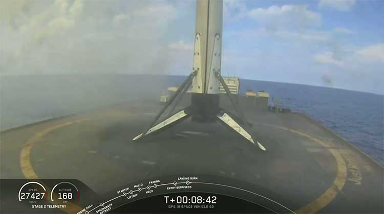
    The first-stage booster of SpaceX’s Falcon 9 Launch Vehicle was successfully recovered approximately 20 minutes after liftoff by the company’s autonomous spaceport drone ship in the predicted landing area. This launch marks the first NSSL mission where a launch provider has attempted to recovered flight hardware.

    “The successful GPS III SV03 launch and recovery serves as another step in our journey with industry partners to create innovative, flexible, and affordable services to meet NSSL mission objectives and propel U.S. dominance in space.” said Col. Robert Bongiovi, Launch Enterprise director. “I’m proud of my team’s 81st successful National Security Space Launch and look forward to our additional National Security Space missions with SpaceX.”

    GPS III’s SV03 separated from its upper stage approximately 88 minutes after launch. Engineers and operators at Lockheed Martin’s Waterton facility will now begin on-orbit checkout and tests which are estimated to complete in two weeks. Operational use is expected to begin as early as August 2020.

    “The GPS III program continues to build on its successes by delivering advanced capabilities for the United States Space Force, and maintaining the “gold standard” for position, navigation and timing.” said Col. Edward Byrne, Medium Earth Orbit Space Systems Division chief.


    UPDATE: The SpaceX Falcon 9 successfully launched the third GPS III satellite at 4:10 ET. The reusable Stage 1 successfully returned and landed on its launchpad less than nine minutes after launch.

    Screenshot: SpaceX live feed of launch
    Screenshot: SpaceX live feed of launch
    SpaceX live feed show Stage 1 returning to landing pad at sea. (Screenshot: Space X)
    SpaceX live feed show Stage 1 returning to landing pad at sea. (Screenshot: Space X)

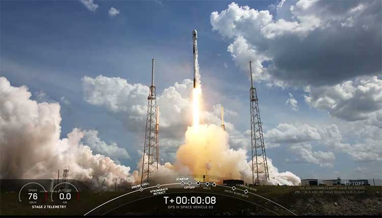
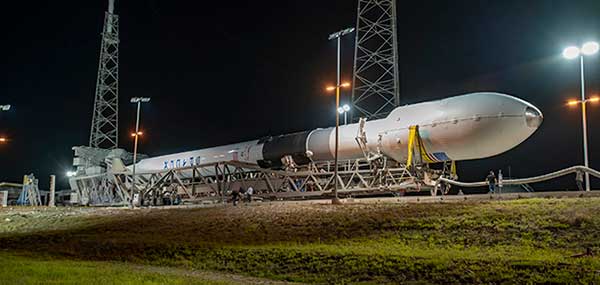
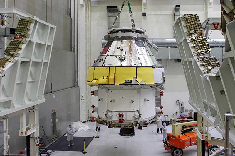
    The U.S. Space Force’s newest Global Positioning System (GPS) III satellite, Space Vehicle 03 (SV03), rolled out to Cape Canaveral’s Space Launch Complex-40 launch pad a during the overnight hours on June 27 and 28, ready for launch June 30 at 3:55 p.m. Eastern time.

    The Lockheed Martin-built GPS III SV03 is scheduled to launch aboard a SpaceX Falcon 9 rocket. GPS III SV03 will be the third USSF mission launch, the second National Security Space launch (NSSL) mission to be launched on a SpaceX Falcon 9 rocket, and the first NSSL mission where a launch service provider will be attempting to recover the booster.

    The launch window opens at 3:55 p.m. EDT and will remain open for 15 minutes. A live-feed will begin 20 minutes prior to the launch, concluding approximately 45 minutes afterward. A simulcast of the broadcast can be viewed at www.spacex.com.

    “The NSSL program’s number one priority is to achieve mission success on each and every National Security Space launch,” said Col. Robert Bongiovi, Launch Enterprise director. “We also strive to procure affordable launch services that maintain assured access to space for the Nation. Our goal with GPS III SV03 was to maintain our mission assurance record, while exploring unique cost saving opportunities like recovering a booster to deliver the capabilities our warfighters demand.”

    “The GPS III program brings a new standard of excellence for the entire space community. Our production team and contract partners have developed an indispensable tool that is available to military and civil users around the world.” said Cordell DeLaPena, program executive officer for SMC’s Space Production Corps. “Our team will continue to advance the launch campaign for the remaining space vehicles and I anticipate the successful launch of SV03 on the Falcon 9.”

    Originally scheduled to launch on April 29, the GPS III-3 mission took a 60-day tactical pause in order to implement new health and safety measures to protect launch and operations crew during the ongoing COVID-19 pandemic. This pause allowed SMC to design and implement these measures in collaboration with contractor and launch provider partners as well as medical professionals. The tactical pause resulted in no impact to the readiness and availability of the GPS constellation, which remains in strong health. There were minimal impacts to cost and schedule due to the pause.

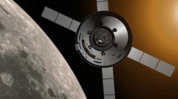
    GPS III SV03 will be launched to augment the current GPS constellation comprised of 31 operational spacecraft. GPS satellites operate in Medium Earth Orbit (MEO) at an altitude of approximately 20,200 km (12,550 miles) in six orbital planes. Each satellite circles the earth twice per day.

    GPS is the premier space-based provider of positioning, navigation, and timing services for more than four billion users worldwide. This latest generation of GPS satellite boasts a 15-year design life — 25 percent longer than the last generation of GPS satellites on-orbit. GPS III brings new capabilities to users such as the new L1C civilian signal, which opens the window for future interoperability with international satellite navigation systems.

    “Our space systems division is filled with exceptional, highly talented team members focused on delivering the next generation of GPS satellites. They are extremely motivated and resourceful, and had to overcome numerous challenges imposed by the COVID-19 pandemic to successfully get us into a position where we can safely launch. I couldn’t have asked for a better team,” said Col. Edward Byrne, MEO Space Systems Division chief. “SV03 is set to join the first two GPS III satellites as we continue our journey to modernize the constellation.”

    GPS III satellite signals are more accurate and more powerful than previous generations, providing improved performance for civilian and military users. SV03 will add another military code (M-Code) capable satellite as the team continues to modernize the GPS fleet. M-Code will provide more accurate military signals with improved anti-jamming capabilities for the warfighter. Full M-Code capability is set to rollout with the GPS OCX Block 2 ground segment.

    GPS III SV 03 rolls to Cape Canaveral’s Space Launch Complex-40 launch pad in preparation for its June 30 launch aboard a Falcon 9. (Photo courtesy of SpaceX via USAF)
    GPS III SV 03 rolls to Cape Canaveral’s Space Launch Complex-40 launch pad in preparation for its June 30 launch aboard a Falcon 9. (Photo courtesy of SpaceX via USAF)

  • Esri ArcGIS Field Maps beta supports Eos Arrow GNSS

    Esri ArcGIS Field Maps beta supports Eos Arrow GNSS

    A new Esri mobile app, ArcGIS Field Maps, will be released in its first beta in July, with the final version expected to be released in September.

    According to Esri, Field Maps will combine the following capabilities into a single app:

    • Simple map viewing and markup
    • High-accuracy field data collection and inspection
    • Battery-optimized location tracking
    • Work planning and task management
    • Turn-by-turn navigation

    Field Maps also will include a new web app, integrated with ArcGIS, that can be used to configure and deploy maps optimized for your mobile workforce needs, create and assign tasks to mobile workers, and create and share views of worker locations.

    Arrow support included

    The inaugural beta includes support for Arrow GNSS receivers’ high-accuracy locations, elevations and metadata, according to Eos Positioning.

    ArcGIS Field Maps will provide the combined functionality of five Esri mobile apps: ArcGIS Collector, ArcGIS Explorer, ArcGIS Tracker, ArcGIS Workforce and ArcGIS Navigator.

    In the first beta version, users will be able to perform markups, work with read-only maps, and work with MMPKs, including  high-accuracy GPS locations and metadata from Arrow GNSS receivers.

    Photo: Eos Positioning
    Photo: Eos Positioning

    Customers who have been wanting to take advantage of high-accuracy GNSS data in apps such as Explorer and Tracker will now be able to with the beta release. Customers who would like to have field crews able to access read-only maps with high-accuracy, for instance (such as during utility locates), this is now a possibility. In addition, crews can take advantage of high-accuracy GPS tracks while tracking.

    ArcGIS Field Maps will also support the two formerly Collector-exclusive Eos solutions Eos Locate and Eos Laser Mapping.

    Eos Locate. This high-accuracy underground mapping solution will be available in ArcGIS Field Maps right away in the first beta release. A single fieldworker will be able to perform real-time, high-accuracy mapping of underground assets using the same workflow he or she had previously used with Collector and Arrow GNSS.

    Eos Laser Mapping. Similarly, laser offsets with Arrow GNSS receivers and LTI laser rangefinders will be available in the first beta of ArcGIS Field Maps. Learn more about laser offsets, including the three workflows for using them, here:

    “We are incredibly excited for the new opportunities ArcGIS Field Maps brings to expand our partnership with Esri,” Eos CTO Jean-Yves Lauture said. “Now our joint customers will be able to use the Arrow GNSS receivers with Field Maps to access high-accuracy location when simply viewing and marking up maps and when logging location tracks.”

    Eos Positioning told its customers, “We encourage all Eos customers currently using Collector, Tracker and/or Explorer to join the beta. Meanwhile, Collector, Tracker and Explorer are planned to continue working as usual, according to the roadmap Esri has outlined.”

  • New DJI map tracks drone-assisted rescues worldwide

    New DJI map tracks drone-assisted rescues worldwide

    Global reference includes more than 400 people rescued by drones to date

    DJI has launched an online reference to track events around the world when a drone helped rescue someone from peril. The Drone Rescue Map shows how more than 400 people around the world have been helped by drones in more than 200 emergencies, and will be continually updated as new rescues occur.

    The DJI Drone Rescue Map has been compiled from news stories and social media posts from authoritative sources such as police departments, fire departments and volunteer rescue squads.

    Each entry on the map includes the location and date of the incident, a brief description, a link to the original story or post, and an easy way to share those incidents online. To make the map as definitive as possible, DJI encourages public safety agencies to share additional drone rescues so they can be included.

    Once a week on average

    The map includes rescues recorded in 27 countries across five continents, and shows how drone technology has moved from an experimental concept to standard public safety equipment.

    The first drone rescue was recorded in Canada in 2013, the next one was more than a year later, and early examples of drone rescues were as likely to be performed by helpful bystanders as by professionals.

    Today, drone rescues are reported about once a week on average, and public safety agencies routinely share those success stories on social media.

    Screenshot: DJI Drone Rescue Map
    Screenshot: DJI Drone Rescue Map

    “The DJI Drone Rescue Map is now the best global reference for how effective drones are in emergencies, and allows the world to see the tremendous impact drones have had in finding lost people, shortening searches, reducing risks to rescuers and saving lives,” said Romeo Durscher, DJI senior director of public safety integration. “Public safety workers already know how drones are revolutionizing their work, and now the rest of the world can see their amazing stories in one place. The DJI Drone Rescue Map honors the incredible rescues they’ve made, and will allow everyone to see how drones help save people in the future.”

    Types of rescues

    The map includes instances of drones:

    • finding people lost in forests, fields and mountains, often in darkness using thermal imaging cameras
    • dropping life preservers to people struggling in water
    • locating boaters stranded on remote waterways
    • helping rescue people who were at risk of harming themselves.

    The map does not include incidents when a drone is simply used as part of a larger search process; instead, a drone must have directly located, assisted or rescued a person in peril.

    Many of these incidents illustrate how drones can find missing people more quickly than a traditional ground-based search, allowing victims to be brought to safety faster, more easily and with less risk and burden for their rescuers.

    In some of the incidents on the DJI Drone Rescue Map, the drone helped accelerate a rescue and allow first responders to operate more efficiently.

    In other incidents, the drone clearly made the difference between life and death.

    Volunteer rescue

    “I know how important drones are for people in distress, because a drone saved my life,” said Jason Mabee, a Maryland man who was injured and near death last year in a local park when he was found by a volunteer drone pilot. “My family and I are eternally grateful that a total stranger was able to use his drone to find me. It’s comforting to know that drones are helping so many other people around the world too, and I hope the DJI Drone Rescue Map demonstrates just why drones are so important in emergencies.”

    “Drones have changed the game for finding and saving people lost in difficult conditions, and twice last year drones made the difference for us in finding and saving stranded hikers in dangerous terrain at night,” said Kyle Nordfors, Drone Team Coordinator for Weber County Search and Rescue in Utah. “Drones helped make these rescues possible while reducing risk and strain on our volunteer rescue force. We’re excited to see our successful efforts represented on the DJI Drone Rescue Map, and we hope it shows people all over the world how important drones are for saving lives and protecting the rescuers.”

    Screenshot: DJI Drone Rescue Map
    Screenshot: DJI Drone Rescue Map

    Rapid increase in rescues

    DJI has previously released two detailed reports on how drones have been used to rescue people from peril around the world. The first, in 2017, counted 59 people rescued by drones, and the second saw the global total rise to 124 by 2018.

    PC Tom Shainberg, senior drone pilot of the Alliance Drone Team for the Devon & Cornwall and Dorset police forces in England, said, “The Alliance Drone Team is proud to be a leader in adapting drone technology for police incidents, and we’re glad to see our successful drone rescues — such as finding a vulnerable man huddled near the edge of a cliff — being shared wider, along with similar accomplishments from other public safety agencies from around the world via the Drone Rescue Map.”

    “Hundreds of examples now make clear that making drones widely accessible, with low barriers to entry and subject to a progressive set of operational regulations, leads inevitably to saving more lives around the world,” said Brendan Schulman, DJI Vice President of Policy & Legal Affairs. “The DJI Drone Rescue Map is a powerful resource for policymakers to understand the impact drones have on protecting vulnerable people in their own communities, and the detrimental consequences of policies that would restrict or discourage the use of drones, or increase the cost of using them. Regions with less favorable operating rules for drones appear to have substantially fewer reports of drone rescues.”

    Seeking submissions

    DJI monitors global news coverage, drone-related social media, and other sources to find new examples of drone rescues, but understands that many similar incidents may not yet be recorded on the map.

    Anyone who knows of a drone-involved rescue not included on the DJI Drone Rescue Map can submit it through a form at the bottom of the map page.

    These submissions will be reviewed for publication on the map, so DJI asks anyone submitting information about a rescue to respect the privacy rights and expectations of the persons involved, and to not share any confidential or sensitive information about agency operations.

  • GPS World welcomes new EAB members

    GPS World welcomes new EAB members

    GPS World magazine is excited to announce two additions to our Editorial Advisory Board.

    Mitch Narins
    Mitch Narins

    Mitch Narins is the principal consultant and owner of Strategic Synergies LLC, a technical and management consulting firm that he formed after retiring following over four decades of U.S. government service. He worked at the Federal Communications Commission as an acquisition engineer for the Field Operation Bureau; supported the U.S. Navy and U.S. Marine Corps as branch chief for Data Terminal Systems and Electronic Warfare Systems; and served more than 26 years at the Federal Aviation Administration as a program manager, systems engineer, and finally as the chief systems engineer for navigation.

    At the FAA, he was integrated into all aspects of aviation sector position, navigation and time systems engineering, standards development, and enterprise architecture efforts in support of the National Airspace System and the Next Generation Air Transportation System (NextGen).

    Narins is a recognized position, navigation, and timing (PNT) expert, who has published numerous articles and delivered many papers at conferences and seminars worldwide. He is a Certified Information Systems Security Professional (CISSP), a Fellow of the Royal Institute of Navigation, an active member of the Institute of Navigation (ION), and a member of RTCA, RTCM, and SAE Standards Committees. He is a recipient of ION’s Norman P. Hays Award and the International Loran Association’s President’s Award and Medal of Merit.

    Stuart Riley
    Stuart Riley

    Stuart Riley is vice president of GNSS technology responsible for GNSS signal processing and products for several Trimble business areas. In this role, he is responsible for the core GNSS technology from signal reception through to the measurement engine that is used in all Trimble GNSS precision products. He oversees GNSS product development for Trimble’s GNSS Real-time Networks, Geospatial, Heavy Civil Construction and InTech OEM Divisions.

    Beginning his career at Trimble in 1995, Stuart has worked on GNSS receiver development in various engineering roles, in addition to holding several management roles. He holds several patents filed and pending in the field of GNSS and is often a guest speaker at international conferences.

    His research interests include improving GNSS performance in harsh environments, and taking measurements from additional sensors along with optimizing the GNSS receiver architecture, especially for the newer GNSS signals BeiDou, Galileo, IRNSS, QZSS and next-generation GPS and GLONASS signals.

    Riley has an electronic engineering Ph.D. in the field of GNSS from the University of Leeds in England. After he graduated, he was a research fellow at the university on a European Space Agency-funded project to develop a prototype GNSS receiver for space applications.

  • SimINERTIAL designed for GPS/INS testing

    SimINERTIAL designed for GPS/INS testing

    Photo: Spirent
    Photo: Spirent

    Testing the full operational performance of GPS/inertial systems usually requires expensive and time-consuming field testing on an appropriate moving vehicle platform. Spirent’s SimINERTIAL system emulates inertial sensor outputs while simultaneously simulating GPS RF signals. This enables controlled, repeatable testing of integrated GPS and inertial units, reducing the need for field trials.

    SimINERTIAL is housed in a PC platform equipped with the appropriate data interface card. The simulated motion data is streamed from Spirent’s state-of-the art SimGEN application via Ethernet to SimINERTIAL, which translates this simulated motion data into representative real-time data streams at the data rate and with the data format appropriate to the unit being tested.

    SimINERTIAL is equipped with fully user-configurable sensor error modeling and supports a range of popular inertial formats. SimINERTIAL architecture is also available in configurations to support transfer alignment and multiple sensor architectures. SimINERTIAL solutions can also be equipped to deliver a barometric altitude output via a MIL-STD-1553B card installed in the SimINERTIAL controller PC.

  • NASA’s Orion travels with Honeywell, Lockheed Martin

    NASA’s Orion travels with Honeywell, Lockheed Martin

    Honeywell, under a contract with Lockheed Martin, will supply guidance and navigation systems for NASA’s upcoming Artemis missions, which will fly humans to the moon for the first time since 1972.

    The companies are supplying key components to NASA’s Orion spacecraft fleet for the Artemis missions. Components include the barometric altimeter, the inertial measurement system, and the GPS receiver.

    Honeywell will provide 14 product types for Artemis missions III through V, including both hardware and software solutions, to support NASA’s lunar missions. NASA awarded Lockheed Martin a long-term, multibillion-dollar production contract for the Orion spacecraft, aimed to meet the space agency’s anticipated needs into the 2030s.

    Working in collaboration with the Orion team over the next decade, Honeywell will support Lockheed Martin and its partners through the development and production of essential guidance and navigation systems, command data handling, and display and control products. The focus of the missions is to conduct science and learn lessons that will help take humans to Mars.

    Honeywell will supply the following types of technology for the Artemis missions:

    First Orion Spacecraft: In this March 30 photo, Orion I is moved to the Final Assembly and Systems Test cell at Kennedy Space Center. The spacecraft returned from Ohio after a successful series of environmental tests at Glenn Research Center’s Plum Brook Station. (Photo: NASA)
    First Orion Spacecraft: In this March 30 photo, Orion I is moved to the Final Assembly and Systems Test cell at Kennedy Space Center. The spacecraft returned from Ohio after a successful series of environmental tests at Glenn Research Center’s Plum Brook Station. (Photo: NASA)

    Guidance and Navigation Systems. Key navigation and guidance solutions, including the barometric altimeter, which tracks the altitude of the Orion capsule in Earth’s atmosphere, as well as the inertial measurement system (INS) and GPS receiver, which track the position and movements of the capsule.

    Command Data Handling. Several data-handling products, including the vehicle management computer, which acts as the central computing platform supporting flight and vehicle control, as well as spacecraft communication functions.

    Displays and Controls. Three display units and struts, seven control panels, and two hand controllers used inside the spacecraft to help astronauts in the Orion capsule monitor and control the vehicle.

    Core Flight Software. Includes the integrated modular avionics software, a key system responsible for supporting maintenance functions sharing flight data information.

    The contract to supply key components of the Orion crew module and service module is being managed and performed out of Honeywell’s facility in Clearwater, Florida. Work is also being conducted at the company’s facilities in Glendale, Arizona, and Puerto Rico.

    Honeywell was part of NASA’s previous crewed space missions, including those that took humans to the moon.


    Featured image: Artist’s concept: NASA

  • OxTS board set ready for system integrators

    OxTS board set ready for system integrators

    Photo: OxTS
    Photo: OxTS

    Oxford Technical Solutions (OxTS) offers a future-proof inertial navigation system (INS) board set for system integrators.

    The xOEM v3 includes the architecture from the company’s IP65-encased xNAV v3 as well as a full range of software interfaces, providing integrators maximum configuration flexibility, real-time monitoring, post-processing and analysis. Software interfaces can be customized using the OxTS NAVsuite. Plugins can be created using the company’s NAVsdk, allowing the xOEM v3’s software to be easily packaged and included as part of a product.

    The board set is compact at 150 grams, which enables manufacturers to seamlessly integrate and build a high-performance INS into their products, such as commercial mapping applications on land and in the air. Its light weight means more payload capacity for other critical components. An add-on lidar georeferencing software package is also available with a sophisticated boresight calibration tool.

    The high-grade MEMS inertial sensors and real-time kinematic (RTK) capable GNSS receiver within the xOEM v3 board set deliver high performance capabilities. The board set provides 0.1° heading accuracy, 0.05° pitch/roll accuracy and 2 cm global position accuracy.

  • NovAtel SPAN prepares for road ahead

    GNSS positioning is highly accurate and reliable — until satellite signals are disrupted. Hexagon | NovAtel has developed SPAN technology that integrates GNSS positioning with inertial measurements for a three-dimensional understanding of position and orientation.

    SPAN technology delivers accurate heading, velocity, azimuth, pitch and roll. NovAtel SPAN-enabled receivers and enclosures are effective across applications, including marine environments to monitor heave movements from waves and autonomous vehicles requiring a higher level of precision and integrity.

    NovAtel has demonstrated SPAN technology’s capabilities in a sensor-fusion project alongside AImotive and STMicroelectronics. Leveraging sensors on a moving vehicle — GNSS, inertial measurements, and cameras for visual odometry — allowed the teams to produce promising results for continuous positioning on real roads, in underground parking garages, and through tunnels. NovAtel’s PwrPak7-E1 enclosure was used as a reference system in the project, gathering data to confirm the accuracy of the sensor-fusion solution.

    Through this project, NovAtel and its partners validated how alternative PNT like SPAN and other sensor fusion solutions complement and extend GNSS positioning availability, accuracy, and reliability.

  • Industry stalwarts remember change agent Javad Ashjaee

    Industry stalwarts remember change agent Javad Ashjaee

    Dr. Javad Ashjaee, Founder and CEO of Javad GNSS, 1949–2020. (Photo: Javad GNSS)
    Dr. Javad Ashjaee, Founder and CEO of Javad GNSS, 1949–2020. (Photo: Javad GNSS)

    The GNSS community was deeply saddened by the loss of Dr. Javad Ashjaee — Javad, as he liked to be called — on May 30. Following are excerpts of comments by GPS World Editorial Advisory Board members and others, all of whom also expressed their heartfelt sorrow.


    Message from The Ashjaee Family

    “Once in a while an individual comes along with a spirit seemingly superhuman, a resolve and constitution seemingly indestructible. Dr. Javad Ashjaee was one such individual. His talent, intellect, commitment and sheer guts were head and shoulders above the rest, much to the chagrin and frustration of his competitors and naysayers. But those closest to him know that he was also simply, beautifully, erringly human. He brought out in the rest of us the strength and wisdom we could not always see in ourselves. Yes, he was a force of nature, as many describe, but Javad never did anything alone. Throughout the years, he has had a sizable family and team, by blood as well as by love, behind each of his many achievements and contributions to his field. He once told us his name, Javad, means ‘generous.’ And that he was. All that he has given to, and all that he has inspired in, his family, team, and professional industry, forms a legacy that will continue for years to come. We, his family, his team, his protégés and protectors, are here to stay and stronger than ever. If he were here, he would surely wonder how his competition would proceed without that fire only he could ‘light up their asses.’”


    Jules McNeff
    VP of Strategy and Programs
    Overlook Systems Technologies

    “Javad was a brilliant innovator, although he could be a bit infuriating at times. He loved to place ads in GPS World in part to poke fun at the DoD for our Selective Availability policies, for which I was the principal defender at the time. Javad was a unique and talented person of tremendous fortitude and intellectual confidence who was never afraid of controversy. The GNSS community will miss his energy.”

    Mitch Narins
    CISSP/FRIN
    Strategic Synergies

    “When I think of Javad, the words that come to mind are ‘brilliant, dedicated, driven, and committed.’ The last time I saw Javad at an ION GNSS+ conference, he knew he was on the side of an argument opposing many other experts in our GNSS community. That did not bother Javad. He was never one to go along to get along — which was one of the reasons he was able to develop such innovative and capable systems. Our GNSS community has lost a leader, innovator and contributor to the science and engineering behind position, navigation and time.”

    Paul McBurney
    Ph.D., CTO and co-founder
    OneNav

    “Javad was a one-man army who was not afraid to fight. From his days at Trimble, where he developed major advancements in receiver software, and through all of his endeavors, Javad produced an impressive amount of truly innovative solutions. He used the LightSquared crisis as an opportunity to add novel front-end filtering to his products, and cleverly marketed it. His writing was unmistakable, featuring the wordsmithing of both an engineer and a salesman. He was a role model to many aspiring GPS entrepreneurs.”

    Tim Burch
    Director of Surveying
    SPACECO

    “Javad’s contributions to the surveying profession helped turn every practitioner into a geospatial information provider. From his early days at Trimble pioneering the commercial-grade receiver to creating his company at Ashtech and embracing GLONASS with GPS, he continued to expand the capability of the GNSS receiver. Many surveyors today, however, only know his name through his latest company, Javad GNSS, and its unique line of receivers and measuring devices, with their distinct green color. Javad was a big part of the GNSS revolution, so the next time someone starts up his/her receiver to collect survey data, take a moment to thank him. His departure leaves a giant hole in the geospatial world.”

    Michael Swiek
    Managing Director, Executive Branch and International
    GPS Innovation Alliance

    “The ‘Original Cast’ of GPS innovators is dwindling. Javad was a complicated, self-made, innovative, and entertaining man. In the many years we knew each other, we worked on shared visions, many challenges, laughed a lot, and disagreed and argued more than a bit. We always remained friends, honest to each other. Javad was a true GNSS pioneer.”

    Ellen Hall
    President and CEO
    Spirent Federal Systems

    “What a loss for everyone. Such a talented person who truly made his mark on the world.”

    Greg Turetzky
    consultant

    Dr. Ashjaee led the signals team of the “Satellites vs. Signals” after-dinner debate at the GPS World Leadership Dinner held during ION GNSS 2008. (Photo: GPS World)
    Dr. Ashjaee leD the signals team of the “Satellites vs. Signals” after-dinner debate at the GPS World Leadership Dinner held during ION GNSS 2008. (Photo: GPS World)

    “I have very fond memories of Javad from the many years we attended
    ION GNSS+ and other industry conferences. I will always remember a spirited ‘Satellites vs. Signals’ debate we had at a GPS World Leadership Awards Dinner. We were equally passionate about the debate — despite not having chosen the opposite sides to which we were attached. These are the memories of Javad I treasure. He was passionate, informed, innovative and really good at playing the game. His spirit of innovation will be missed, but I am confident it will be carried on by other members of the GNSS community of which he was such an important part.”

    Alison Brown
    President and CEO
    NAVSYS

    “I am so sorry to hear about Javad’s passing. He was an innovator and an originalist. We worked together after he left Trimble and was in the process of starting Ashtech. I particularly remember his championing the cause, with me, against Selective Availability. He ran an ad with the iconic image of the Mona Lisa as part of this cause, with the slogan “Why ruin a work of art?” It is tragic that Javad fell victim to COVID-19. He will be sorely missed.”

  • ArduSimple integrates Sapcorda in multiband RTK GNSS receiver

    ArduSimple integrates Sapcorda in multiband RTK GNSS receiver

    The basic ArduSimple RTK kit includes Sapcorda SAPA. (Image: ArduSimple)
    The basic ArduSimple RTK kit includes Sapcorda SAPA. (Image: ArduSimple)

    ArduSimple has integrated Sapcorda’s SAPA Premium Service into its new simpleRTK2B+SSR GNSS receiver. The user-friendly integration based on SSR technology allows plug-and-play real-time kinematic (RTK) without the need for a base station. Users can connect the receiver to their PC or tablet to achieve centimeter-level accuracy.

    Based in Berlin, ArduSimple develops user-friendly, affordable RTK receivers and tools for evaluation of multi-band GNSS technology.

    The simpleSSR basic starter kit includes a multi-band RTK receiver, SSR receiver, one year unlimited data package and one year SAPA Premium license. Accurate position is available via USB, UART and I2C, as well as via Bluetooth, Wi-Fi or RS232 with the corresponding accessory.

    “ArduSimple’s vision is to make RTK technology affordable and accessible to everyone. Removing the hassle of the base station is a key step towards it,” said Josep Olivart, Senior Consultant at ArduSimple. “The decision to select Sapcorda was clear: best in class service performance at affordable mass market price, supported by a highly skilled and committed team.”

    Sapcorda provides GNSS augmentation services for the internet of things (IoT), automotive, and industrial applications across the United States and Europe including up to 20 kilometers off coastlines, delivered with low-bandwidth data over internet and satellite, and providing uniform, high-integrity instantaneous sub-decimeter positioning on a continental scale with enterprise-level service availability.

    “Sapcorda aims to establish GNSS precise positioning in mass-market applications and ArduSimple is an ideal partner for the integration of our services into a high precision GNSS hardware,” said Botho Graf zu Eulenburg, managing director at Sapcorda. “The combination of our advanced services with ArduSimple’s new platform provides an easy to use and affordable high precision solution to everyone.”

  • TopXGun Robotics uses drones to fight COVID-19 from above

    TopXGun Robotics uses drones to fight COVID-19 from above

    Photo: TopXGun/Septentrio
    Photo: TopXGun/Septentrio

    In early February, TopXGun Robotics — based in Shanghai, China — started to use 10L drones for spraying disinfectant to help fight COVID-19. Six volunteers provided free disinfectant spraying service to more than 10 large companies, factories and universities, covering about 800,000 square meters in the Shanghai area.

    TopXGun outlined the advantage drones have over manual spraying.

    Safety. Using a UAV means no wokers inhale disinfectant. Pilots stay distant, and no one enters a sprayed building until it is safe.

    Effectiveness. By spraying from above, drones can reach difficult locations, such as a landfill or a roof. Reportedly, the spray can kill the virus in the air.

    Cost-savings. Only one pilot and one assistant are required to operate, reducing labor costs.

    The 10L drones are equipped with Septentrio’s high-precision GNSS, which provides robust anti-spoofing and anti-jamming capabilities, important in urban areas.

    Before spraying, TopXGun used a XC-05 vertical-takeoff-and-landing (VTOL) drone to survey the area. With reliable real-time kinematic (RTK) technology from the Septentrio receiver, the survey drone accurately generated a map of the operation area, marking the flight route. In this way, the spraying drone could fly and spray automatically in most cases. If the operation area is in an irregular shape or has obstacles in the middle — such as poles or trees — the mapping pilot can use markers to indicate these obstacles so the spraying drone will avoid it.

  • Taking to the field during the coronavirus pandemic

    Taking to the field during the coronavirus pandemic

    City officials in Sarasota, Florida, kept their staff actively working during COVID-19 social distancing mandates by training and tasking them with mapping utility data in the field.

    The city’s plan to rebuild its GIS database had an estimated five-year timeline. GIS Coordinator William Rockwell suggested to city manager Tom Barwin that those unable to work from home be trained to collect the data. Rockwell worked with Sarasota IT Director Herminio Rodriguez to calculate the cost of acquiring enough GNSS receivers for the idle staff to use, and discovered a substantial cost savings.

    Hands-on training took place in the Sarasota City Hall parking lot, with trainees practicing social distancing. (Photo: Eos Positioning)
    Hands-on training took place in the Sarasota City Hall parking lot, with trainees practicing social distancing. (Photo: Eos Positioning)

    “By implementing this project, we not only keep city staff productive, but we’ll also be collecting data that would otherwise cost hundreds of thousands of dollars if we outsourced the work,” Rockwell said.

    Training from a Distance. Rockwell obtained affordable Arrow 100 GNSS receivers from an Eos Positioning distributor and hosted small-group training sessions in the city hall parking lot. Employees from a multitude of different departments were trained, such as a parking enforcement officer and a transportation planner.

    All employees were carefully kept six feet apart. From a maintained distance, Rockwell explained the basic concept of data collection using high-accuracy Arrow 100 receivers with ArcGIS Collector.

    The new team mapped 93% of street lights and road signs in one month. (Photo: Eos Positioning)
    The new team mapped 93% of street lights and road signs in one month. (Photo: Eos Positioning)

    The employees took turns collecting sample data so Rockwell could address any initial concerns. He also gave each of them a printed map series, created in ArcGIS Pro, that showed the city divided into 28 grids. This allowed the team members to easily mark off where they collected data each day.

    At the end of each day, the workers synced their data, collected by the Arrow 100s, to ArcGIS Online, which allowed Rockwell to monitor progress.

    To date, 14 field workers have collected 93% of the city’s 6,000 street lights and 16,000 road signs. Although the 30-day project pilot has finished, the city plans to collect the remaining lights and signs, as well as the city’s 35,000 trees, later this year. High-accuracy GIS data collection has received encouraging feedback from management.

    “I’m thrilled the city is supporting this initiative,” Rodriguez said. “To be able to take employees doing very, very different jobs and put them in the field — this wouldn’t have been possible in a normal environment. We are excited that everyone is chipping in.”