Author: Tracy Cozzens

  • Keeping interference at bay for critical infrastructure

    Keeping interference at bay for critical infrastructure

    An international survey and analysis on GNSS interference detection and localization systems reveal the path forward for transportation and other critical infrastructure.

    By José Luis Madrid-Cobos and Ana Bodero-Alonso, ENAIRE
    Ignacio Fernández-Hernández and Eric Châtre, EC
    Andriy Konovaltsev, DLR, and Christopher Hegarty, MITRE

    An ENAIRE GNSS RFI monitor close to the Madrid-Barajas Airport in Madrid, Spain. (Photo: ENAIRE)
    An ENAIRE GNSS RFI monitor close to the Madrid-Barajas Airport in Madrid, Spain. (Photo: ENAIRE)

    The received power of GPS and Galileo navigation signals at the antenna output of a user receiver is typically extremely small, from approximately –165 up to –150 dBW, which makes them inherently vulnerable to radio-frequency interference (RFI) caused by the emissions of other radio systems. This interference is often unintentional, such as from malfunctioning or spurious emission from a transmitter in the vicinity of the GNSS receiver.

    However, we have seen numerous reports about the deliberate jamming of GNSS signals. The most frequent examples of such interference reports are caused by so-called personal privacy devices (PPDs) — low-power GNSS jammers used to locally disable the operation of GNSS receivers. Although the use of PPDs is illegal, they can be easily acquired on the internet. A $10 jammer with 100 mW of transmitter power is enough to degrade performance or disrupt GNSS receivers in a range of 10–100 meters. In the past decade, more complex and powerful jammers have also become available, along with spoofers — devices that create GNSS-like signals that fool receivers to provide false location or time solutions. A $100 software-defined radio bought online can be used as a spoofer.

    ENAIRE (the Spanish air navigation service provider) conducted an international survey and associated analysis of GNSS RFI detection and localization systems. The survey was part of the EU–U.S. Working Group C Sept. 2017–Sept. 2019 Work Plan, with contributions of the European Commission (DG DEFIS), the German Aerospace Center (DLR), the U.S. Federal Aviation Administration (FAA), Eurocontrol, the MITRE Corporation and Stanford University. Working Group C promotes cooperation between the U.S. and EU on design and development of the next generation of civil satellite-based navigation and timing systems. The survey was conducted within the Resilience Subgroup focused on counteractions required in view of growing concerns over jamming and spoofing threats.

    Manufacturers and Users

    The survey was provided in two versions: one targeted to manufacturers and another to the users of interference detection systems. The two surveys were implemented online July 12–Oct. 26, 2018. There were 23 responses: 11 from manufacturers and 12 from users (see Acknowledgments below for companies that participated). Regarding the manufacturers’ responses, the nine surveyed companies represent about 50% of the market of RFI monitoring products available in 2018.

    RFI Equipment Used

    We present here the aggregated results of the RFI equipment manufactured and used by the participating entities.

    Frequency Bands and Signals. The L1/E1 band is covered by all of the manufacturers’ and users’ surveyed products. L5/E5a and other bands are monitored in only 42% of the cases, or even less. Most RFI systems demodulate or analyze the GPS L1 C/A signal. Only 8% and 17% of users analyze GPS L5 and Galileo E5a, respectively.

    Capabilities. 55% of the industry, and 25% of the users’ surveyed products, provide RFI localization capabilities, while 45% of the industry, and only 33% of the users’ surveyed products, detect some type of spoofing.

    Power and Antenna Gain. Most of the systems achieve a sensitivity better than or equal to –120 dBm, meeting the International Civil Aviation Organization requirement for GPS and SBAS L1 airborne receivers to withstand interference (–120.5 dBm CW, in-band) after steady-state navigation has been established. The gain of antennas used in RFI detection systems ranges from 2 dBi up to 45 dBi.

    Real-Time Bandwidth. The maximum real-time monitored bandwidth of the surveyed products ranges from 16 MHz up to 60 MHz in L1. Most of the products monitor a 20-MHz bandwidth (similar to the GPS L1 C/A reference bandwidth for pre-GPS III satellites, which is 20.46 MHz).

    Spectrum Refresh Time. The time needed by the RFI detector to capture and process a plot of the RF spectrum in a specific band to look for interference signals ranges from 1 microsecond to 2 seconds.

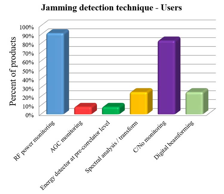
    Jamming Detection Techniques. The most widespread jamming detection technique is RF power monitoring (45% industry, 92% users), followed by digital beamforming (CRPAs), carrier-to-noise-density ratio (C/N0) monitoring and spectral analysis/transforms (see Figure 1). Note that RF power monitoring and automatic gain control (AGC) monitoring are in essence the same detection technique: AGC voltage levels — after calibration with a reference RF generator — can be converted into RF input power levels.
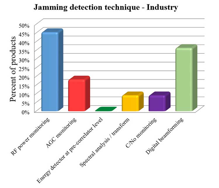
    Figure 1a. Jamming detection techniques used by industry. (Chart: RFI survey)
    Figure 1a. Jamming detection techniques used by industry.
    (Chart: RFI survey)
    Figure 1b. Jamming detection techniques of users. (Chart: RFI survey)
    Figure 1b. Jamming detection techniques of users. (Chart: RFI survey)

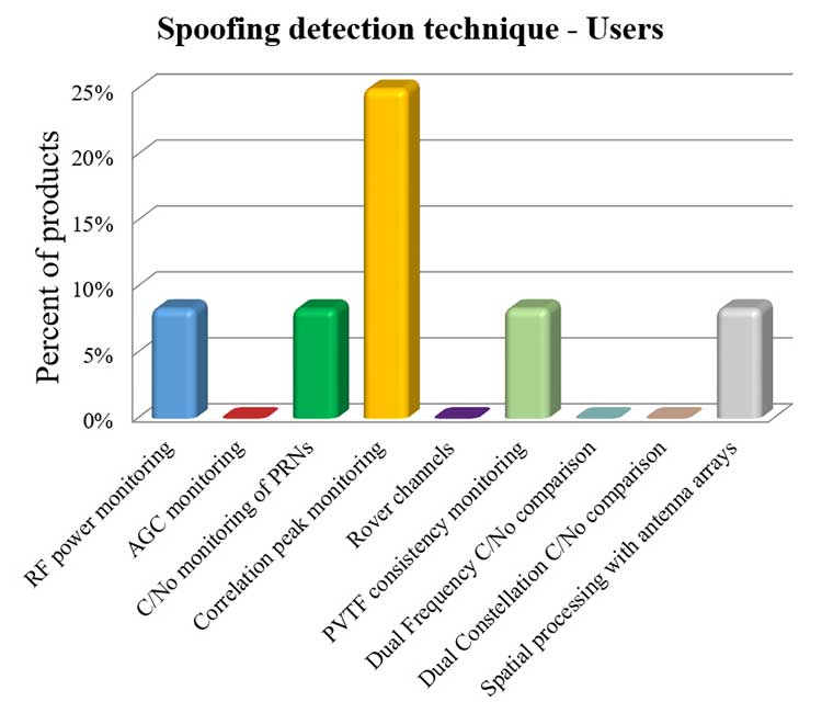
    Spoofing Detection Techniques. The most widespread spoofing detection techniques are PVTF consistency monitoring (industry products, 27%) and correlation peak monitoring (users, 25%), followed by digital beamforming (CRPAs), C/N0 monitoring and spectral analysis/transforms (see Figure 2).
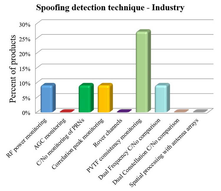
    Figure 2a. Spoofing detection techniques used by industry. (Chart: RFI survey)
    Figure 2a. Spoofing detection techniques used by industry.
    (Chart: RFI survey)
    Figure 2b. Spoofing detection techniques of users.(Chart: RFI survey)
    Figure 2b. Spoofing detection techniques of users.(Chart: RFI survey)

    Localization. The most widespread RFI localization technique is direction/angle of arrival (DOA/AOA): 55% in industry products and 25% in users’ systems. AOA techniques used are correlative interferometer (phase-difference), Watson-Watt (amplitude-difference) and array signal processing. The AOA accuracy of surveyed products ranges from ±3° to ±10°.

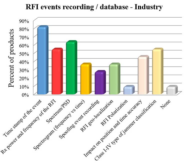
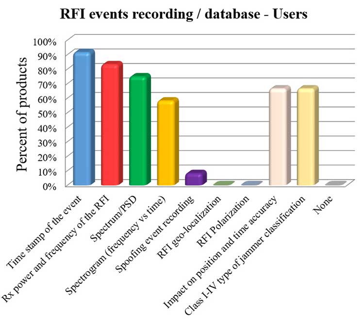
    Event Recording. For an interference event, most products record the time stamp, received power, central frequency, frequency spectrum, the spectrogram (frequency versus time plot) and the jammer type. Only 8% of surveyed users perform spoofing event recording (see Figure 3). 92% of users record RFI/spoofing events; half also report them to their national spectrum administration. Users have from one to 11 jammer detectors. Only four users have been registered with spoofing detectors, each using one.

    Figure 3a. RFI events recording/database used by industry. Jammer classifications: Class I — continuous wave signal; Class II — chirp signal with one saw-tooth function; Class III — chirp signal with multi saw-tooth functions; Class IV — chirp signal with frequency bursts. (Chart: RFI survey)
    Figure 3a. RFI events recording/database used by industry. Jammer classifications: Class I — continuous wave signal; Class II — chirp signal with one saw-tooth function; Class III — chirp signal with multi saw-tooth functions; Class IV — chirp signal with frequency bursts. (Chart: RFI survey)
    Figure 3b. RFI events recording/database of users. Jammer classifications: Class I — continuous wave signal; Class II — chirp signal with one saw-tooth function; Class III — chirp signal with multi saw-tooth functions; Class IV — chirp signal with frequency bursts. (Chart: RFI survey)
    Figure 3b. RFI events recording/database of users. Jammer classifications: Class I — continuous wave signal; Class II — chirp signal with one saw-tooth function; Class III — chirp signal with multi saw-tooth functions; Class IV — chirp signal with frequency bursts. (Chart: RFI survey)

    Event Sharing. 75% of surveyed users are willing to collaborate in the creation of an international RFI and spoofing events common database, but the remaining 25% explicitly do not want to share their databases.

    Future RFI Monitoring Equipment

    Based on the analysis of the aggregated results from the survey, we identified some recommendations for improving RFI monitoring:

    L5/E5a band. To be ready for introduction of the L5/E5a band into aviation operational use (expected by 2025), it is suggested that aviation organizations increase efforts to monitor and analyze the RFI situation in the L5/E5a band.

    Spoofing detection. National organizations in charge of critical infrastructures should increase their efforts to detect spoofing (at least at the same level as jamming detection). Multi-constellation and dual-frequency spoofing detection should be promoted (not only L1/E1 spoofing).

    GNSS RFI monitoring with enough bandwidth: The maximum real-time monitored bandwidth of the surveyed products ranges from 16 MHz to 60 MHz, while most of the products monitor only a 20-MHz bandwidth. The receiver reference bandwidth for E1 is 24.552 MHz, while for L1 GPS III it is 30.69 MHz. U.S.-EU GNSS RFI detection systems for critical infrastructures should be designed to monitor at least 31 MHz of bandwidth in the L1/E1 band, with 50 MHz recommended to cope with typical –3 dB bandwidth of pre-low-noise-amplifier (LNA) GNSS L1/E1 receiver filter. The same rule should be applied to other GNSS bands. Even more bandwidth for monitoring could be needed to cope with rare interferers, such as a high-power source, whether intentional or unintentional, radiating in near-band L1/E1 but not in the passband frequencies, bypassing the rejection of the receiver’s filters and degrading the GNSS signal reception.

    Air Navigation

    In the EU, performance-based navigation (PBN) will become the norm in all flight phases, and GNSS (with or without SBAS) will be the main position source, by June 2030. A similar scenario is being developed in the U.S. Conventional procedures and ground-based navigation aids will be used only in contingency situations. GNSS RFI can degrade the current GBAS CAT I (GAST-C) service in airports and could jeopardize safe operation of upcoming GBAS CAT II-III (GAST-D) service. GNSS also is the key enabler for ADS-B.

    Therefore, it is critical for air transportation to improve its capability to detect radio frequency interference to GNSS and mitigate its harmful effects, both on the ground and in the air.

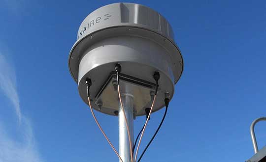
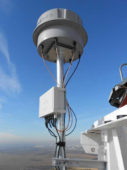
    Ground Detection and Localization. These systems should be installed at and around all airports. ENAIRE has recently deployed an AOA RFI detection and localization system around the Madrid airport called DYLEMA. It consists of nine AOA RFI and spoofing detectors, two spoofing-only detectors, an IP communication network and a GNSS monitoring center operated 24/7. From this center, ENAIRE will report RFI events to the Spanish spectrum agency. Similar systems will be deployed in other large Spanish airports in the next years. In small airports, ENAIRE is deploying single-unit RFI detectors (one detector per airport, currently without the AOA feature). These systems are complemented by handheld and airborne spectrum analyzers equipped with directional antennas and RFI AOA features, used if an RFI event of high power or duration takes place.

    Airborne Detection and Localization. Several initiatives are under study or initial design for airborne detection and localization systems, using current avionics receivers with no hardware modification or new hardware such as additional antennas in the aircraft. Future airborne RFI detection systems should include indoor coverage to detect jammers and spoofers in the airplane itself. EUROCONTROL is leading one of these initiatives using ADS-B. Given a reliable ADS-B data feed with suitable coverage information, a search algorithm could scan for outages. If the data is dense enough, it is possible to locate the source, even if the GNSS airborne antenna is omnidirectional with no AOA features. Another commercial initiative, GATEMAN, uses new GNSS antennas and components to provide AOA detection and localization features.

    UAV-Embedded Detection and Localization. Detection and localization systems embedded in UAVs are not widely commercially available, but they will be useful to complement fixed or ground RFI monitoring systems, especially to detect fast moving mobile jammers and spoofers. A jammer moving at high speed could be found by a fixed detector, trigger the UAV take-off (collocated with the detector or close to it), and start tracking the target. If equipped with a camera, it could identify the vehicle carrying the jammer or spoofer. Such a system has to function in GNSS-denied scenarios, and needs to use sensors other than GNSS. Stanford University has recently developed a prototype of such a system.

    Other Sectors

    Shipping. RFI detection systems should be installed at and around harbors, where positioning requirements are the most stringent. Mobile AOA detectors can be installed in vessels. A DLR experiment integrated its GALANT GNSS RFI detector on a ship sailing from Spain to South Korea and back.

    Railroads. Detection and localization systems should be installed at train stations and main railway junctions or switches. It is possible to install mobile detectors in trains to detect jammers inside the train apart from outdoor coverage to detect jammers outside the train.

    Roads. Most PPD jammers in use are on roadways. Jammers not only jeopardize aviation and timing systems; they can jeopardize the safety of the coming autonomous road vehicles. We strongly recommend that police and road surveillance systems include jammers and spoofers as a daily target, to detect, localize and punish their users.

    Supporting proposals include installing fixed detectors at tollbooths, road gantries or other points near roads; and using mobile detectors — for example, on police vehicles for locating a car that carries a jammer. Public transport services with enough vehicles (such as taxis or busses) could also detect RFI.

    Smartphone Platforms. Initiatives are using smartphone crowdsourcing platforms to detect interference based on C/N0 or AGC measurements. At this time, only prototype apps for Android phones are available. The Apple iOS does not allow access to GNSS raw data. Android applications can include localization capabilities based on Time Difference Of Arrival (TDOA) or Power Difference Of Arrival (PDOA). Having a detection system in a mass-market product would create millions of detectors around the world. Reward programs by national or local administrations would encourage use of the app. User consent to obtain the data will be needed.

    Space-Based Detection. Space-based detection is feasible to find medium- to high-power jammers and spoofers. Several projects have performed simulations, such as the ground to space threat simulator from Qascom and Spirent Communications. In this project, simulations achieved an error of less than 1.5 km using a medium-Earth-orbit (MEO) satellite as the RFI sensor and a 20-dBm static jammer on Earth, with 15 minutes of observation time. Also, an experimental program from the International Space Station has demonstrated that RFI can be detected from low Earth orbit.

    The main issue of such detection systems is the cost to deploy all the satellites needed to have a global coverage with a low response time (2 hours or less to detect RFI). The performance of a space-based RFI system is better when using a LEO constellation (as, compared to an MEO system, it detects RFI with a lower transmitted power). One such system by HawkEye 360 was deployed in 2019. The company plans to operate a fleet of 30 satellites in LEO orbit, enabling it to gather new signals from any point on the planet within 30 to 45 minutes.

    General Recommendations

    Increased Effort Needed. Public administrations and transport service providers should increase their efforts to deploy GNSS RFI detection and localization systems. In parallel, governments should punish individuals or organizations using jammers or other types of illegal transmitters or emissions. Jamming and spoofing is illegal in the EU and the U.S. An increased RFI monitoring effort should be coordinated at the national or regional level to find synergies and avoid duplications.

    Planned Interference. Government agencies, including national radiofrequency spectrum agencies, should coordinate nationally and internationally with air, rail, road, maritime and other critical infrastructure entities before any planned intentional interference is conducted, such as military exercises or protection of special events from potential terrorist attack. This coordination includes an analysis of the estimated area and airspace volume affected by the RFI, the associated notification to the GNSS users before and during the RFI radiation period (such as a NOTAM, Notice to Airmen), as well as the indication to use established alternative procedures (non-GNSS).

    A Common Database. The creation of an international common database of GNSS RFI events could boost the fight against GNSS RFI. A specific action could define a standard of the RFI data format to be registered and shared in an international database, including a possible RFI classification (also defined and agreed to as part of the standard). One initiative related to the creation of an international GNSS RFI threats database was proposed by the EU-funded STRIKE 3 project in 2017.

    Acknowledgments

    The work presented in this report has been performed under the U.S.-EU Agreement on GPS-Galileo Cooperation, Working Group C, Resiliency Subgroup. The authors thank the participants of the Working Group and the Resiliency Subgroup — in particular, Eurocontrol and the FAA for distribution of the survey in the EU and the U.S., respectively. The authors also thank the organizations that participated in the survey: Spirent Communications, GMV, Centum Solutions, THALES, IDS AirNav, Chronos Technology, Innovationszentrum für Telekommunikationstechnik (IZT), Collins Aerospace, German Aerospace Center (DLR), Netherlands Aerospace Centre (NLR), Deutsche Flugsicherung (DFS), Direction des Services de la Navigation Aérienne (DSNA), Polish Air Navigation Services Agency (PANSA), Belgocontrol, ENAV and ENAIRE.


    José Luis Madrid-Cobos is the technical manager of GNSS interference detection and localization systems at ENAIRE, the Air Navigation Service Provider in Spain. Ana Bodero-Alonso is the head of the Satellite Navigation Department at ENAIRE. Ignacio Fernández-Hernández is responsible for Galileo high accuracy and authentication at the European Commission. Eric Châtre is the head of the GNSS Exploitation and Evolutions Sector at the European Commission. Andriy Konovaltsev is a research assistant at Institute of Communications and Navigation of the German Aerospace Center (DLR). Christopher Hegarty is a technical fellow with The MITRE Corporation.

  • Orolia Coffee Talk covers vulnerability testing for PNT Executive Order

    Orolia Coffee Talk covers vulnerability testing for PNT Executive Order

    Orolia will host a second industry discussion on the positioning, navigation and timing (PNT) Executive Order, a federal initiative to protect critical infrastructure from GPS/GNSS jamming and spoofing threats, and other PNT service disruptions.

    Speakers include:

    • John Pottle, Director, Royal Institute of Navigation
    • Greg Gerten, Director of PNT Operations, Centauri Corp.
    • Tyler Hohman, Director of Products, Orolia Defense and Security

    The first Orolia PNT Coffee Talk, which focused on jamming and spoofing, is available here.

    The second session — which takes place July 16, 2 p.m. EST — will explore the importance of vulnerability testing to protect critical infrastructure with Resilient PNT technologies. The defense industry has addressed complex GNSS and PNT threats longer than any other sector, and experts will share their insights and best practices to help inform the protection strategy for critical infrastructure identified in the Executive Order.

    Image: ONYXprj/iStock / Getty Images Plus/Getty Images
    Image: ONYXprj/iStock / Getty Images Plus/Getty Images

    Vulnerability testing with GNSS simulation is essential to protect critical infrastructure. However, there is no one-size-fits-all approach. This testing requires the ability to customize scenarios per application. It also needs to identify gaps across a variety of unique and geographically distributed systems.

    Test results provide the basis to select the best PNT technologies to increase resilience, while ongoing regular testing ensures that critical systems can adapt and overcome evolving threats.

    The Orolia PNT Coffee Talk is for those interested in learning more and discussing the latest developments in this national priority from industry and government perspectives.


    Orolia PNT Coffee Talk

    Vulnerability Testing for Critical Infrastructure: Lessons Learned from Defense

    July 16, 2 p.m. EST

    Register here.


  • Microchip updates BlueSky GNSS Firewall Software

    Microchip updates BlueSky GNSS Firewall Software

    Image: Microchip
    Image: Microchip

    U.S. Department of Homeland Security’s live-sky testing evaluations influenced development of BlueSky GNSS Firewall Software Release 2.0

    Microchip Technology Inc. has released a major software update for its BlueSky GNSS Firewall product, providing a higher level of resiliency against GPS vulnerabilities for systems dependent on GPS signal reception.

    Such systems include critical infrastructure such as power utilities, financial services, mobile networks and transportation that rely on GPS-delivered timing to ensure ongoing operations.

    Microchip’s BlueSky GNSS Firewall Software Release 2.0 performs real-time analysis to detect jamming and spoofing for protecting reception of the GPS signal and hardening response and recovery to avoid signal disruption.

    Release 2.0 includes charting and advanced threshold settings of GNSS observables such as satellites-in-view, carrier-to-noise, position dispersion, phase time deviation and radio frequency (RF) power level to simplify system turn-up and deployment.

    The release also includes improvements developed by Microchip as a result of participation in a 2019 industry live-sky testing event hosted by the U.S. Department of Homeland Security (DHS) Science and Technology Directorate.

    Microchip’s participation in the DHS-hosted GPS Testing for Critical Infrastructure (GET-CI) events included scenarios with spoofed signals, and helped the company identify new solutions to prevent signal disruptions. As a result, Microchip developed the Release 2.0 to address operators’ evolving requirements.

    As a leader in frequency and time systems, Microchip continuously innovates GPS signal reception security technologies for commercial and military operators similar to how network firewalls protect against virus threats. Updates are essential to defend against rapidly-evolving GNSS disruptions and enable critical infrastructure operators to avoid interruptions of service.

    When connected to Microchip’s TimePictra management software, critical infrastructure operators can monitor and analyze GNSS signals in cities, across geographic regions, throughout a country and even globally.

    Other complementary devices and software in Microchip’s suite of GPS systems and services include the TimeProvider 4100 Precise Timing Grandmaster with Gateway Clock, SyncServer 600/650 timing and frequency instrument, miniature atomic clock (MAC), Time Cesium and 5071A cesium primary frequency standard.

  • Geotab launches public works solution for government fleets

    Geotab launches public works solution for government fleets

    Helps enable state and municipal government agencies to improve fleet operations and increases operational efficiencies

    Photo: THEPALMER/E+/Getty Images
    Photo: THEPALMER/E+/Getty Images

    Geotab, an Internet of Things (IoT) and connected transportation company, has launched its Geotab Public Works solution in North America.

    The all-in-one solution offers fleet managers full visibility into the operational data of all government vehicle types on a single platform,and provides the toolsets to effectively remain compliant, reduce costs and maintain road safety.

    Designed to help government agencies better manage vehicles such as salt spreaders, snowplows, street sweepers and waste management vehicles, the Geotab Public Works solution is integrated with an extensive number of spreader controllers.

    The solution is built to support key government business drivers including material management, compliance, accountability and liability. Providing public works departments with improved fleet management capabilities, fleets can utilize the solution to more accurately measure material usage, such as salt, allowing government fleet managers to feel more confident that community roads are not over- or underserviced.

    With Geotab Public Works, government fleets are better able to control costs while reducing the impact that excessive material usage can have on the environment.

    “Empowered by an industry-leading number of spreader controller integrations alongside various geospatial capabilities, the Geotab Public Works solution is designed to help government fleets optimize both their seasonal and ongoing fleet operations,” said Chris Jackson, associate VP of Business Development, Public Works and Smart Cities. “Spreader controllers provide fleet managers with rich insights that can help government agencies ensure that their fleets are adequately servicing roads without sacrificing the health of the environment.”

    Available as a configurable add-in on the MyGeotab platform, the Geotab Public Works solution allows governments, including municipalities of all sizes, to customize their database to help meet the specific needs of their fleet.

    In addition, users can add further value and customization through access to the Geotab Marketplace, an extensive portfolio of mobile apps, software add-ins and hardware add-ons that enable Geotab customers to further customize the fleet management solution.

    “As many governments continue to look for ways to optimize their operations, Geotab Public Works is the type of robust, scalable, secure solution that provides real value by giving government fleet managers and local constituents unprecedented visibility to their public services,” said Jean Pilon-Bignell, vice president of Business Development, Government and Smart Cities at Geotab. “With high-frequency, near real-time reporting, the Geotab Public Works solution allows governments to know where their fleets are and how they are operating at all times, enabling fleet managers to more efficiently leverage their fleet data to provide better and more transparent services to their residents.”

  • First Fix: Don’t wait to update GPS

    First Fix: Don’t wait to update GPS

    By Paul Crampton, Spirent Federal

    Paul Crampton
    Paul Crampton

    As we bid farewell to the last GPS-IIA satellite and read of delays to both the launch schedule for GPS III satellites and roll-out of the OCX program, we are mindful of the need to maintain GPS as the “Gold Standard” in GNSS.

    Certainly, new signals, enhanced resilience and expanded capabilities are offered by the modernized GPS playbook. Delays relative to both the BeiDou and Galileo constellations could seriously impact the position of GPS on the medals podium — maybe not in the longer term, but certainly in the coming few years.

    This may have a secondary impact on the receiver market, shifting focus away from GPS to more capable signals in the near term. Once GPS has caught up, receiver manufacturers may choose to retain the technology that they developed to capitalize on BeiDou and Galileo signals, rather than developing their legacy GPS capabilities.

    GPS L2C is currently “pre-operational,” transmitted by slightly more than half the existing mixed-generation satellite fleet and waiting for OCX support. As of Feb. 20, a realistic estimate for operational capability of GPS L2C is now 2023.

    GPS L5 is also pre-operational, transmitted by slightly less than half of the GPS satellites and waiting for OCX support. As of Feb. 20, a realistic estimate for GPS L5 is 2027.

    The forecast for GPS L1C operational capability is the late 2020s. This is intended to be the signal that offers international interoperability with the current interoperability signals offered by existing BeiDou and Galileo satellites.

    Delays to the implementation of GPS L1C may mean that GPS misses the interoperability boat entirely. During the delay, new interoperability capability with even more robust signals could be devised and lofted aboard Galileo, BeiDou and GLONASS satellites. By then, other countries could also develop their own constellations, possibly regional or even global systems.

    Potentially, GPS could be left behind as other nations discuss non-GPS internationally interoperable signals on yet-to-be launched satellites. This may have a profound impact on SBAS, too. Differential corrections provided by the Japanese MSAS, Russian SDCM and European EGNOS SBAS systems might evolve to support “beyond L1C” interoperability signals. Aircraft landings at world airports could mandate the use of corrections to these new signals. This might mean that U.S. receiver manufacturers could be frozen out, or will have to incorporate these new interoperable signal standards.

    GPS Block III satellites along with OCX offer improved signals, capabilities and resilience, but the satellites need to be flying, OCX needs to be operational and receivers need to be in the hands of the users. Sooner rather than later is a must for Gold-Standard GPS.


    Paul Crampton is a senior systems engineer at Spirent Federal Systems with more than 30 years of GPS experience.

  • ComNav launches R550 GNSS data collector for the field

    ComNav launches R550 GNSS data collector for the field

    Photo: ComNav
    Photo: ComNav

    ComNav Technology has released the new-generation data collector R550.

    With its new industrial-level design and new hardware platform, the R550 is designed to ensure efficiency and productivity in the field.

    The IP67 dust-and-waterproof rating protects the R550 from most harsh environments. Equipping it with 7,000 mA Li-ion battery allows more than 14 hours of continuous operation, while fast-charging technology means it only takes four hours to fully charge the collector via the type-C interface port.

    The 5-inch-wide sunlight-readable, high-resolution screen provides a smooth experience for any operation. The integrated autofocusing camera helps enhance job documentation by taking photos on site and sharing job information with colleagues.

    Survey Master field software available on the R550 controller ensures efficient surveys in the field, including topographic surveys, stakeouts, coordinate geometry (COGO) and more.

    Powered by the Android 8.1 operating system and designed with 4G RAM, 64GB ROM and 4G/BT/Wi-Fi on board, users can run other third-party apps based on their specific requirements.

    The R550 data collector now is available through ComNav Technology authorized local distributors or ComNav Technology directly.

  • ‘Keep GPS Working’ coalition fights FCC Ligado decision

    ‘Keep GPS Working’ coalition fights FCC Ligado decision

    Coalition’s first action is to endorse Inhofe-Reed legislation forcing Ligado to provide financial relief to consumers, industries and other end users

    Five organizations representing thousands of companies and millions of Americans have launched a new coalition to protect end users of GPS following the Federal Communications Commission’s (FCC’s) April 22 decision to permit Ligado Networks to operate a terrestrial wireless network using its satellite spectrum.

    Ligado’s planned use of its L-band spectrum — adjacent to bands used by GPS — would threaten the reception capability of hundreds of millions of GPS devices, according to the coalition.

    Founding members of the Keep GPS Working Coalition include

    • Association of Equipment Manufacturers (AEM)
    • American Farm Bureau Federation (AFBF)
    • American Road & Transportation Builders Association (ARTBA)
    • Aircraft Owners & Pilots Association (AOPA)
    • Boat Owners Association of The United States (BoatU.S.)

    As its first action, the Keep GPS Working Coalition will endorse the Recognizing and Ensuring Taxpayer Access to Infrastructure Necessary for GPS and Satellite Communications Act, which is expected to be formally introduced this week by Sens. Jim Inhofe (R-Okla.) and Jack Reed (D-R.I.).

    GPS IIIF’s M-Code can be broadcast from a high-gain directional antenna in a concentrated, high-powered spot beam, in addition to a wide-angle, full-Earth antenna. (Artist rendering: Lockheed Martin)
    GPS IIIF’s M-Code can be broadcast from a high-gain directional antenna in a concentrated, high-powered spot beam, in addition to a wide-angle, full-Earth antenna. (Artist rendering: Lockheed Martin)

    The coalition explained in a press release,

    The FCC’s decision threatens GPS reliability for countless consumers, farmers, ranchers, pilots, boat owners, surveyors, construction companies and other private GPS users who will be forced to suffer interference to their GPS devices or to pay to replace them.

    The FCC admits in its order that there are cases where both government and private GPS receivers — including those that power aviation, agriculture and other key industries — will suffer harmful interference, but failed to provide a technically feasible and adequate remediation solution for consumer and business end users.

    The FCC also failed to conduct an open and comprehensive rulemaking process before issuing the Ligado order, instead circulating a final decision only among FCC commissioners while major stakeholders grappled with the COVID-19 pandemic.

    Notably, the FCC ignored established technical standards determining whether GPS devices would suffer harmful interference, instead relying on limited studies using vague and impractical criteria to assess interference with the GPS signal, while disregarding mountains of evidence on the topic under the established methodology.

    “In issuing the Ligado order, the FCC threw millions of Americans who depend on GPS in their everyday lives under the bus with undue haste and inadequate consideration,” said Dale Leibach, spokesperson for the Keep GPS Working Coalition. “Alarmingly, the commission also ignored concerns raised by Congress and federal agencies — the experts that rely on GPS to protect our national and economic security — including the Departments of Defense, Transportation, Commerce, Interior, Justice and Homeland Security, as well as NASA, the National Science Foundation, the Coast Guard and the Federal Aviation Administration. DOD has even argued before Congress that the interference from Ligado’s network would put missions and troops at risk. It is a highly questionable decision that benefits a single company and its Wall Street investors at the expense of national and economic security.”

    “The Keep GPS Working Coalition will ensure that the concerns of end users are represented in this critical public policy debate, joining the chorus of experts sounding the alarm over the Ligado order’s existential threat to GPS technology and urging the FCC to reverse its decision,” the press release stated.

    “In the interest of the agriculture, construction, and other off-road equipment manufacturers, the Association of Equipment Manufacturers is taking a firm stance against the recent FCC Ligado decision,” said Kip Eideberg, Senior Vice President of Government and Industry Relations for AEM. “The FCC decision impacts millions of private GPS devices, many of which are used by farmers, contractors and consumers who depend on a reliable connection to plant, harvest, construct and move goods. We thank Senators Inhofe and Reed for their leadership and for introducing this legislation that will begin to address the wrongdoings the Ligado order will cause, and we urge the FCC to reconsider their imprudent decision.”

    “America’s farmers and ranchers rely on precision agriculture technology and GPS so their farms and ranches can be more efficient, economical and environmentally responsible. Expanding broadband access is a top priority for Farm Bureau but not at the expense of losing the accuracy of GPS,” said Zippy Duvall, President of AFBF.

    “The FCC’s actions threaten the profound improvements GPS has made possible in the construction industry, including increased efficiency, productivity and improved safety,” said Dave Bauer, President and CEO of the American Road & Transportation Builders Association. “ARTBA stands with our fellow Keep GPS Working Coalition members as we aim to reverse the FCC’s decision.”

    “Reliable GPS is critical to aviation safety, a fact that was not adequately weighed by the FCC before reaching its decision. AOPA is grateful for the opportunity to represent aviation stakeholders as part of the Keep GPS Working Coalition,” said Jim Coon, Senior Vice President for Government Affairs for the Aircraft Owners & Pilots Association.

    “The GPS technology that America’s boaters rely on every day is once again threatened by the FCC’s recent decision,” said David Kennedy, Government Affairs Manager of BoatU.S. “BoatU.S. is honored to be part of the Keep GPS Working Coalition and looks forward to working with the coalition’s other members to protect this critical technology.”

    According to the coalition, in addition to requiring Ligado to satisfy additional conditions prior to the order becoming effective, the bipartisan Inhofe-Reed legislation would ensure the costs incurred by businesses and consumers as a result of the FCC’s decision would be covered by the licensee benefiting from the decision — in this case, Ligado.

    “The Keep GPS Working Coalition thanks Senators Inhofe and Reed for introducing the Recognizing and Ensuring Taxpayer Access to Infrastructure Necessary for GPS and Satellite Communications Act, which acknowledges the potential harm to GPS end users caused by the Ligado order and ensures the burden of cost sits squarely where it belongs — on Ligado, rather than our farmers, pilots, boat owners, surveyors or construction companies,” said Leibach. “While we strongly urge the FCC to reconsider its position on this matter, we are deeply grateful to Senators Inhofe and Reed for recognizing the tremendous expense and burden the Ligado order places on American businesses and consumers and providing clear and immediate relief to critical stakeholders.”

    For more information about the Keep GPS Working Coalition, visit www.keepgpsworking.com.

  • CHC Navigation introduces BB4 UAV and AlphaUni lidar combination

    CHC Navigation introduces BB4 UAV and AlphaUni lidar combination

    Lidar series paired with professional drone provides multi-platform, high-accuracy 3D laser scanning for geospatial and mapping professionals

    CHC Navigation (CHCNAV) has launched the multi-rotor BB4 drone and AlphaUni 300/900/1300 lidar.

    Photo: CHCNAV
    Photo: CHCNAV

    The combination of the AlphaUni 300/900/1300 lidar and BB4 UAV solutions creates a comprehensive and versatile range for 3D mapping and geospatial data acquisition in land, air and marine applications.

    “The purchase of a 3D mobile mapping system is too often constrained to a specific purpose, such as airborne or ground survey,” said George Zhao, CEO of CHCNAV. “A lot of our customers expressed the need to have a professional lidar solution that can be used in different scenarios, offering optimal adaptability to their current and future needs.

    “With our AlphaUni series, we are now introducing an innovative response with a multi-platform lidar system that can be used with an aerial or marine drone, on a vehicle or carried as a backpack,” Zhao said. “In addition, the long flight autonomy of our new BB4 UAV allows missions over large areas in a single flight for exceptional productivity.”

    AlphaUni lidar series

    Photo: CHCNAV
    Photo: CHCNAV

    The new AlphaUni series enhances CHCNAV’s Alpha Mobile Mapping family with a light, versatile long-range laser scanner systems available on the high-end market.

    The series provides optimized data sets powered by advanced GNSS/inertial navigation system (INS) sensors and long-range Riegl scanners.

    AlphaUni’s design adapts to a variety of applications and can be installed on a variety of platforms, including multi-rotor UAV, fixed-wing vertical-takeoff-and-landing (VTOL) UAV, vehicles, rail trolleys, backpacks, boats and more.

    BB4 UAV

    The BB4 UAV is a high-end multi-rotor drone optimized for the CHCNAV AlphaUni 300/900/1300 lidar series. Its modular design simplifies deployment in just a few minutes.

    Its 7-kg payload breaks the capacity barrier, and more than 45 minutes of flight time increases the airborne lidar survey ability.

    The redundant CHCNAV and DJI inertial measurement unit (IMU) and GNSS units provide reliable centimeter real-time kinematic (RTK) positioning, meeting the demand for high accuracy in the geospatial and mapping industry.

  • ComNav releases cost-effective M300 Plus GNSS CORS receiver

    ComNav releases cost-effective M300 Plus GNSS CORS receiver

    ComNav Technology has released the M300 Plus GNSS receiver to the international market.

    The M300 Plus is designed to supplement the company’s M300 Pro, which is aimed at clients who need a more economical version for their CORS networks. The M300 Plus not only can be used as a CORS receiver, but is a good choice for monitoring projects and other applications.

    With ComNav Technology’s new-generation GNSS engine, the M300 Plus can track all current and future constellations. By using a powerful, adaptive detecting and canceling technology, the M300Plus provides enhanced anti-jamming capability, which is critical for a reference station providing reliable GNSS data.

    Photo: ComNav
    Photo: ComNav

    The M300 Plus’ powerful built-in web server provides full remote control of the receiver configuration, status checking, firmware update and data download. It supports multiple independent data transfer through TCP/UDP/Ntrip protocol in RTCM, ComNav binary, NMEA and BINEX data formats, combined with Email Alert and FTP push, which improves the efficiency and profitability of businesses.

    In addition to its standard Ethernet port for data transmitting, the M300 Plus GNSS receiver also fully implements a 4G module as an internet backup, which enhances the stability of data connections.

    M300 Plus is now available through ComNav Technology authorized local distributors or ComNav Technology directly.

  • GMV creates mobile app to for safe return to work

    GMV creates mobile app to for safe return to work

    GMV logoTechnology multinational GMV has launched Covclear, a mobile app to ensure a safer and more efficient return to work after the COVID-19 lockdown.

    The application helps to make sure offices will be a safe workplace while minimizing the risk posed to the health of employees or other persons who are working in open workplaces in an environment of maximum safety and protection.

    The app is collaborative and relies on a principle of co-responsibility between the company and its employees to protect their own health and the health of their relatives and workmates.

    Covclear integrates all the following in a single platform: a daily medical health check of all employees; recording of trips to restricted sites; contact tracing within the firm; control of office access by means of temperature readings; quarantine management; and control of site occupancy. It also publishes the company’s healthcare crisis rules.

    First and foremost, it offers a self-check prepared by clinicians to assess the state of people and pinpoint any contagion risk before they commute to work. On the basis of employees’ daily responses, the app determines their risk level on their own phone, generating a workplace accessing QR color code.

    A red code would trigger automatic three-day contract tracing, giving all these contacts instant and anonymous warning so they can act accordingly. All this is conducive to the ongoing safety of all work colleagues.

    Covclear also allows for management of site occupancy, assigning days of on-site working to employees and thereby ensuring maintenance of optimum occupancy levels in places with a large number of workstations.

    The app developed by GMV has been designed to protect information at source, thereby guaranteeing data-protection compliance at all times. The company will have access only to the QR code color for carrying out the corresponding access control and to gain an overview of the company’s state of health.

    Covclear, which is already successfully up and running in some company offices, springs from the company’s own safety needs. It has been set up in only a few weeks thanks to the company’s wealth of expertise in the development of technology and mobile apps.

    At the same time, and mindful that it could be useful for third parties, GMV is also making this app available to its clients and suppliers and to any other firm that might be in need of such safe going-back-to-work services.

    Covclear includes four applications: iOS and Android user apps, an Android personnel access control app, and an administration web tool for the company. The data is kept in totally dependable, GDPR-compliant cloud servers.

  • China completes BeiDou-3 worldwide navigation constellation

    China completes BeiDou-3 worldwide navigation constellation

    BeiDou constellation. (Image: BeiDou program)
    BeiDou constellation. (Image: BeiDou program)

    China completed its worldwide BeiDou navigation satellite system with the launch of its final satellite on June 23, according to China Global Television Network.

    The satellite launched aboard a Long March-3B carrier rocket from the Xichang Satellite Launch Center at 9:43 a.m. Beijing time (0143 GMT) on Tuesday, marking the completion of the country’s domestically developed BeiDou constellation.

    The launch followed a delay of after originally being scheduled for July 16 because of a technical issue discovered in pre-flight tests.

    The final satellite is a geostationary earth orbit satellite of the BDS-3 system. It is the 30th BDS-3 satellite and the 55th BeiDou satellite. BDS-3 is a a 30-satellite navigation system.

    BDS-3 offers high-precision positioning and short message communication.

    Begun in 1994, BDS-1 was completed in 2000 to provide services to China. In 02012, BDS-2 was finished, and has provided navigation service to the Asia-Pacific region. Once the final satellite achieves orbit and is checked out successfully, BDS-3 will provide navigation services worldwide.

    Screenshot: China Global Television Network
    Screenshot: China Global Television Network
  • GeoCue releases 3D UAS systems with Applanix inside

    GeoCue releases 3D UAS systems with Applanix inside

    Photo: GeoCue
    Photo: GeoCue

    GeoCue Group has released the True View 615 and True View 620 UAS lidar 3D imaging systems. The True View systems are compact, survey-grade 3D imaging sensors designed for small unmanned aerial systems.

    True View 615 and 620 are equipped with Riegl’s miniVUX-2UAV laser scanner integrated with dual photogrammetric cameras. Position and orientation is provided by an Applanix APX-15 (True View 615) or extreme accuracy APX-20 (True View 620).

    All True View 3D imaging systems are bundled with Applanix POSPac, True View EVO post-processing software and True View Reckon data management solution.

    The Riegl laser scanner and dual photogrammetric cameras have been carefully configured to provide a fused lidar/imagery field of view of up to 120°. The system includes full post-processing software that generates a stunning ray-traced 3D colorized point cloud and geocoded images.

    An upgrade path will be available to promote a True View 615 to a True View 620 by adding the Applanix APX-20 external inertial measurement unit.

    The True View product line gives mappers and surveyors the ability to deliver high-quality analytic data with exact accuracies. These deliverables are generated using workflows and tools within GeoCue’s post-processing software, True View EVO. Examples of derived products include bare Earth models, profiles, cross sections, topographic contours, volumetric analysis and more.

    “Our Quanergy-based True View 410 has rapidly become the standard for general purpose drone 3D Imaging, where moderate vegetation penetration and accuracies of 5 cm RMSE are adequate,” said GeoCue’s President, Lewis Graham. “The True View 615/620 provides a solution for situations where deeper vegetation penetration, wire extraction and extreme accuracy are required. These are great new additions to the True View product line.”

    The True View 615/620 will be available for shipment late June.