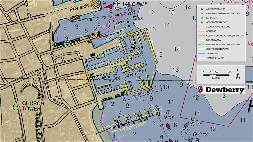
Existing NOAA nautical chart of Nantucket Harbor, Mass., overlaid with revised shoreline features collected by Dewberry. Image courtesy of Dewberry. (Image: Dewberry/NOAA)
Dewberry has been selected by the National Oceanic and Atmospheric Administration (NOAA) for the agency’s Shoreline Mapping Services contract. The five-year, indefinite delivery/indefinite quantity (IDIQ) contract has a ceiling of $40 million and will enable Dewberry and its partners to work with NOAA’s National Geodetic Survey to develop new technologies and initiatives to protect the nation’s coasts.
This is Dewberry’s second consecutive shoreline mapping services contract for NOAA. Over the past five years, the firm completed 30 task orders across the nation, including research studies to analyze bathymetric point tracing, derive bathymetry from satellite data, and apply INSAR data to analyze subsidence.
Task orders also included shoreline mapping in Alaska; creating topobathymetric lidar and shoreline products from NOAA-acquired data in Connecticut, Puerto Rico, the Chesapeake Bay, Florida and Maryland; acquiring and processing topobathymetric lidar data in Puerto Rico, the U.S. Virgin Islands, Texas and Massachusetts; and developing topobathymetric elevation and shoreline mapping datasets along the Atlantic seaboard from Myrtle Beach, South Carolina, to Long Island, New York.
“We are excited to continue to support and partner with NOAA to update the national shoreline, nautical charts, and provide high-resolution topography and bathymetric data to enhance the National Coastal Mapping Program,” said Amar Nayegandhi, CP, CMS, GISP, Dewberry’s senior vice president and senior project manager for the contract. “We always strive to find the most appropriate technology and solutions for NOAA and its numerous stakeholders. The task orders we received under the previous contract are a testament to the breadth of geospatial, scientific, and technology services we offer to NOAA.”
Dewberry also conducted special initiatives such as supporting the GRAV-D program to assist in developing the new gravimetric geoid model for 2022 and the 3D Nation Requirements and Benefits Study in collaboration with NOAA and the U.S. Geological Survey (USGS).
The 3D Nation Study documents topographic, coastal, and bathymetric 3D elevation data requirements and benefits across a multitude of geographies, helping to establish a baseline understanding of national business uses, needs and associated benefits for 3D elevation data.
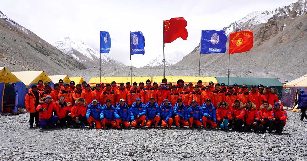
The survey team and sherpas reach the top of the world. (Photo: CHC Navigation)
China’s field work for new measurements of Mount Everest — the world’s, highest peak — are now complete. However, it will take two to three months for scientists to calculate and release its exact height, according to CHC Navigation, whose GNSS receiver was used.
The eight-member Chinese survey team reached the summit on May 27. The team erected a survey marker and installed a GNSS antenna on the snow-covered peak. The team also conducted a GNSS survey, snow depth measurement and gravity survey, said China’s Ministry of Natural Resources.
Scientists will use multiple traditional and modern measurement techniques to perform comprehensive calculations of the measurement data. After data analysis and processing, they will carry out theoretical studies and repeated verifications to determine the accurate height. Complex calculations are needed to eliminate errors caused by factors such as temperature, air pressure and the refractive environment.
U.S. Federal Communications Commission (FCC) Chairman Ajit V. Pai has responded to a congressional letter expressing objections to the April 20 FCC decision to allow Ligado to establish a broadband network.
In a May 27 email sent to GPS World, the FCC wrote, “Given your interest in the Ligado order that the Commission adopted unanimously last month, we wanted to share with you the text of the letter Chairman Pai recently sent to members of Congress on this topic.”
The five-member FCC voted unanimously in April to approve an order to allow Ligado Networks to deploy a low-power nationwide 5G network. Experts and policy makers have said the broadband network could — or likely would — interfere with reception of GPS signals.
On May 7, a bipartisan group of 23 members of the House Armed Services Committee (HASC) sent a letter to the FCC questioning the decision, and this is the letter the FCC is now responding to.
The letter from Committee Chairman Adam Smith (D-Wash.) and Ranking Member Mac Thornberry (R-Texas) says the FCC order did not comply with Section 1698 of the National Defense Authorization Act for Fiscal Year 2017. That act prevents the commission from approving commercial terrestrial operations in certain portions of the L-band spectrum until 90 days after the commission resolves concerns of harmful interference to GPS devices.
The Senate Armed Services Committee held a hearing on the topic on May 6 with Department of Defense officials, and on May 15, 32 senators asked the FCC to address their concerns and stay the Ligado approval order while doing so.
“GPS has no right to operate in the spectrum in question, so there is nothing for Ligado to share.” — FCC Chairman Pai
The letter insists that GPS will remain protected. “Although your letter references the shared use of spectrum, the Commission’s L-band decision does not authorize any spectrum sharing between Ligado and GPS. In fact, spectrum in this band has been licensed to Ligado and predecessor companies for over 30 years — with those companies authorized to deploy terrestrially since 2004. And as mentioned above, one of the FCC’s conditions require separation of Ligado’s operations from GPS spectrum by means of a 23-megahertz guard band. Thus, any implication that the Commission has authorized Ligado to “share” spectrum that is currently allocated to GPS is incorrect. GPS has no right to operate in the spectrum in question, so there is nothing for Ligado to share.”
Download the full letter to Rep. Smith here. Download HASC letter to the FCC here.
The email to GPS World included the following statement: “The FCC is required by law to make its decision based on the facts in the record, and federal agencies, including the Department of Defense, were provided with multiple opportunities to put whatever facts they believed to be relevant into the record, including classified information, which the Commission has a process in place to protect.
“The Commission based its decision on all of the information in the record. Moreover, we are not aware of the FCC refusing any request by the Department of Defense to provide a briefing related to this matter.
“To the extent any federal agency opposed to the Ligado application chose not to share information with the Commission, that was the agency’s decision and suggests that it did not believe that the information in question would bolster its case.”
Spectrum regulation is much like land-use zoning: certain services are kept separate to avoid disturbing the neighbors. The U.S. Federal Communications Commission (FCC) has in effect allowed Ligado to build an outdoor concert venue next to a monastery, and by way of compensation, they offer free earplugs.
GPS/GNSS signals are extremely weak and the receivers are extremely sensitive. To give some perspective, by the time they get to the GPS receiver, GPS signals are about a factor of 20 less powerful than cosmic background noise. Ligado’s spectrum was licensed for mobile satellite services (MSS) and so was not likely to interfere with GPS.
“The U.S. Federal Communications Commission (FCC) has in effect allowed Ligado to build an outdoor concert venue next to a monastery, and by way of compensation, they offer free earplugs.”
With its new, and much more valuable license, Ligado now has a legal right to build a terrestrial cellular service. Exhaustive testing over the past 10 years has repeatedly demonstrated that such a system will interfere with high-precision GPS/GNSS receivers used in surveying, timing and Earth observation. The Department of Defense (DOD) has also made strong claims that such a system will cause harm to its systems. In all cases, the effect is much like riding a bicycle at night. You can see fine until someone comes around the corner with the high beams on and blinds you.
In its earlier filings, Ligado had asked for permission to transmit at a power level of 1500 Watts. In an amazing piece of legerdemain, they convinced the FCC, but not the Department of Transportation (DOT) or DOD, that by reducing transmit powers to 10 Watts, there would be no harm. This is a stunningly erroneous claim. As you lower the transmit power, you need many more cellular base stations to cover a given area. To use an analogy from my backyard, I can install one high-flow sprinkler head to cover the entire yard or a bunch of low-flow heads, each covering a small portion. Either way, the grass doesn’t care about anything other than inches of water, and I’m going to get wet if I run across the yard. Ligado’s core argument is equally wet. Nonetheless, it has great appeal to people who don’t understand how cellular systems work.
So, moving forward and assuming the license stands, interference events will become more prevalent and GPS will be deemed “less reliable.” Because interference sources are largely untraceable, blame will rarely attach to Ligado. I expect that GNSS receiver vendors will incorporate improved filters into receivers and pass the cost along to buyers. Ligado, or more likely whoever it sells the spectrum to, will quickly move to petition for increased transmit powers to lower capital costs; after all, more base stations cost more. And so, the Visigoths have arrived, 4G in hand with a 5G label.
Logan Scott is founder and owner of Logan Scott Consulting, www.gpsexpert.net.
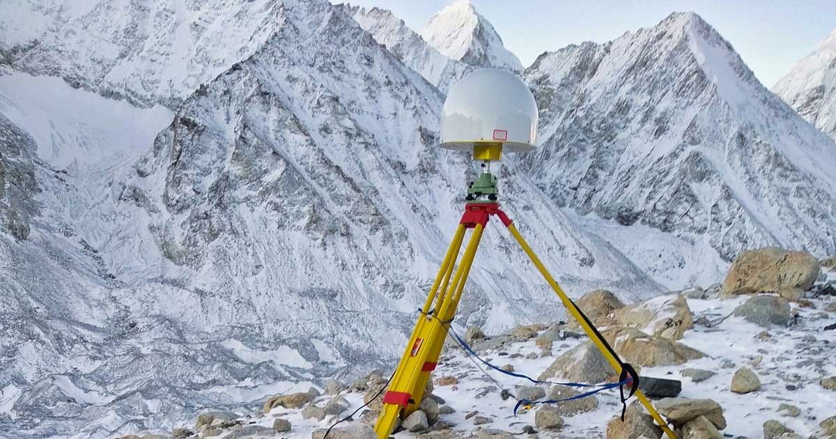
CHC Navigation’s P5 geodetic GNSS receiver was successfully used by a Chinese team of surveyors to complete the 2020 Mount Everest Elevation Survey.
This is the first time that a team of Chinese surveyors has climbed the summit of Mount Everest, and it is also the first time that BeiDou-based Chinese GNSS receivers have been used to measure the height of Mount Everest, known in China as Mount Qomolangma.
China’s National Geodetic Survey Team and its Mountaineer’s Team used CHCNAV GNSS receivers. (Photo: CHC Navigation)
The Everest Project
To promote research on the Mount Everest elevation and to ensure the scientific character and accuracy of measurements, the Ministry of Natural Resources mobilized the Shaanxi Bureau of Topography and Geographic Information Mapping from the Chinese Academy of Topography and Mapping to plan and implement the measurements of the Mount Everest elevation. China’s National Geodetic Survey Team and its Mountaineer’s Team would undertake the arduous climb.
The plan set out the technical guidelines and required that the Everest Elevation Project be designed to achieve innovative and technological breakthroughs in several areas of research.
The first is to use the BeiDou satellite navigation system to perform GNSS measurements; the second is to use Chinese surveying and mapping equipment to complete the task.
Meeting Harsh Challenges
In October 2019, CHCNAV received a request from the Ministry of Natural Resources to provide GNSS equipment for the 2020 Everest Elevation Project. A dedicated team combining different departments, from R&D to manufacturing, was set up. The team elaborated the specific technical requirements from the National Survey engineers, in particular the difficulties and challenges related to the altitude of Everest.
Measuring the height of Mount Everest, especially the summit, is a challenge, not only for the limitation of the human body in such elevation environment, but also for the performance of the GNSS receiver itself.
At over 8,800 meters, the minimum temperature can reach -45°C and the atmospheric pressure is only 30 kPa (compared to the normal 101 kPa). All the surveying equipment used is exposed to both low temperature and low-pressure constraints.
In addition, the operation of the instruments must be as simple and reliable as possible in such an extreme environment. Surveyors wear thick winter clothing and lack oxygen, making every movement an extreme challenge. Finally, the measurement of the mountain peak must be completed at the first attempt, as re-measurement is impossible.
To meet these stringent requirements, CHCNAV has provided GNSS receivers that have passed the most rigorous environmental and reliability tests. The entire solution, from the GNSS receivers to the accessories, has been optimized to ensure mission success from the very beginning.
A wide temperature range of material — supporting an operating temperature range of –45°C to +85°C — were used, including redesigned lithium-ion batteries offering 12 hours of operation even at extremely low temperatures. Also used were antenna cables with a specific compound material to avoid any cracking or signal attenuation.
To ensure reliable operation of the receivers in a low-pressure environment, the GNSS receivers have built-in waterproof and breathable valves to maintain internal and external pressures. The low-pressure tests replicated a 25-kPa environment, corresponding to an altitude of 10,000 meters.
Additional ruggedized reinforcement prevented damage in the event of accidental receiver drop thanks to a robust design to keep the display and connectors safe. Following CHCNAV tests, third-party organizations were commissioned to perform environmental testing and reliability verification, including storage and operating at high/low temperatures, vibration, shock, rain, dust, humid heat, salt and fog.
From November 2019 to March 2020, CHCNAV’s GNSS equipment was supplied to the National Photoelectric Rangefinder Testing Center — under the requirements of the China Academy of Surveying and Mapping — for the most rigorous evaluation. As a result, the company’s GNSS receivers were selected to provide the peak altitude measurements of Everest in 2020.
The climb to the summit. (Photo: CHC Navigation)
Reaching the Summit
On April 5, 2020, at the Everest Elevation Survey Expedition Ceremony in Lhasa, CHCNAV officially donated GNSS equipment to the National Survey Team. Both product and technical training was provided to the team.
The 53 members of the first National Survey Team overcame the difficulties related to the environment, bad weather and the additional impact of COVID-19, and conducted a series of measurements on Mount Everest and surrounding areas such as level, gravity and GNSS.
Thirty of the 60 points of the GNSS control network were measured with CHCNAV GNSS receivers, including three of the seven Everest elevation intersection points.
On May 27, the CHCNAV GNSS receivers finally reached the summit and successfully completed the task.
The successful achievement of the Everest elevation measurement reflects the performance of the Chinese surveying and mapping industry, confirms BeiDou as a major part of the GNSS systems, and demonstrates the technical success of CHCNAV as a major player in the GNSS industry.
About CHC Navigation
Founded in 2003, CHC Navigation is a publicly listed company creating innovative GNSS navigation and positioning solutions. With a global presence across the world, distributors in more than 100 countries, and more than 1,300 employees, CHC Navigation is today recognized as one of the fastest-growing company in geomatics technologies.
“Seen & Heard” is a monthly feature of GPS World magazine, traveling the world to capture interesting and unusual news stories involving the GNSS/PNT industry.
Photo: Mt. Qomolangma/miljko /E+/Getty Images
Chinese surveyors take BeiDou to the top
On May 6, more than 30 Chinese surveyors left base camp to summit Mount Qomolangma — known in the west as Mount Everest. The team is using both traditional and modern surveying and mapping technologies, and China’s BeiDou Navigation Satellite System (BDS) will be applied to the elevation survey for the first time. The previous survey in 2005 used GPS to measure the height (found to be 8,844.43 meters); this year’s survey uses all four GNSS, with BDS data as the main reference.
Image: BlackJack3D/E+/Getty Images
Quantum entanglement
In a paper published April 20 in Physical Review Letters, University of Arizona engineering and optical sciences researchers, in collaboration with engineers from General Dynamics Mission Systems, demonstrate how a combination of two techniques — radio frequency photonics sensing and quantum metrology — can give sensor networks a previously unheard-of level of precision. The work involves transferring information from electrons to photons, then using quantum entanglement to increase the photons’ sensing capabilities. The quantum-sensing paradigm could create opportunities to improve GPS receivers, astronomy laboratories and biomedical imaging capabilities, as well as improve the performance of any application that requires a network of sensors.
Researchers evaluating movement of GNSS ground stations have discovered large-scale, back-and-forth ground movement preceding the 2010 seaquake off of Chile and the 2011 Tohoku-oki seaquake off of Japan. Researchers from the Geoforschungszentrum Potsdam (GFZ) with collaborators from Chile and the United States say both quakes showed multiple strange reversals of ground motion — an extremely slow “wobbling” of the continental plate — over a period of five months (for Japan) and seven months (for Chile). The discovery was made possible by the amount of data collected by the GNSS stations in both countries.
Dogbot on patrol
A robot dog from U.S.-based Boston Dynamics reminded visitors to Bishan-Ang Mo Kio Park in Singapore to maintain social distancing due to the coronavirus pandemic, reported the BBC in May. The dogbot is fitted with lidar to monitor how busy the park becomes. It also carried a loudspeaker to broadcast social-distancing messages.
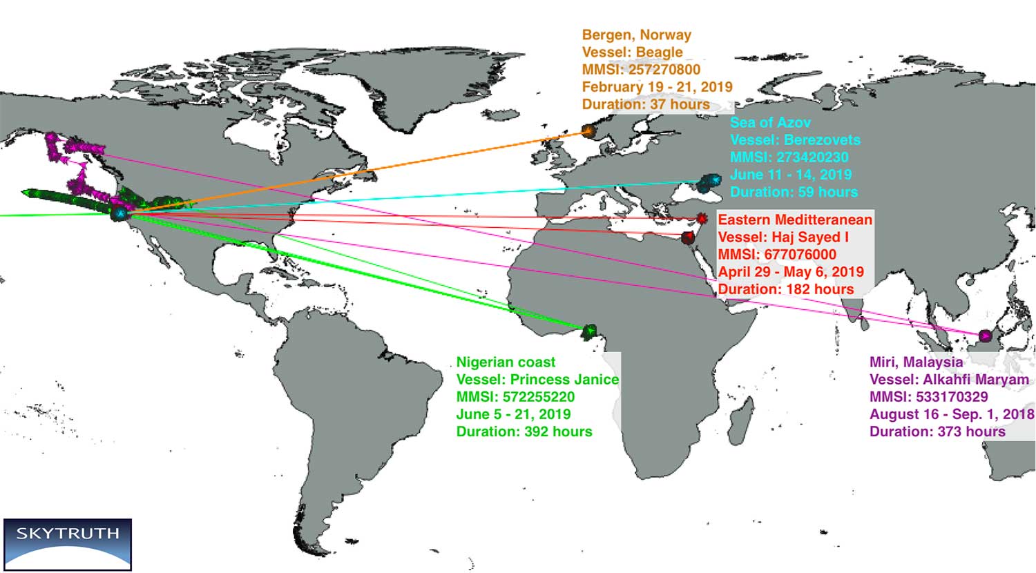
New research by Bjorn Bergman of the environmental non-profit SkyTruth has found ships in various parts of the world reporting locations thousands of miles away and circling at precisely 20 knots.
Bergman’s findings were first reported at the annual meeting of the Resilient Navigation and Timing Foundation on May 5.
Bergman previously observed and reported on circling phenomena with GPS-based reporting systems from vessels and fitness trackers in China ports. It has also been observed in Tehran, Iran. In all those cases, though, it was clear that the real location was fairly nearby the false and circling locations.
In the most recent observations, the actual locations of the ships were thousands of miles away. In most cases, literally halfway across the globe.
Image courtesy of Skytruth and RNTF.
Bergman said that he was able to verify the vessels’ approximate true location by examining the field of view of the satellite receiving the automatic identification system (AIS) position reports. The satellites are only able to see an area about 5,000 kilometers wide.
A satellite that could only see the Gulf of Guinea in West Africa, for example, received GPS-based location data from a ship’s AIS that showed the vessel offshore of Point Reyes in northern California. The vessels’ true locations were also confirmed by their position reporting before and after the “displacement events.”
Bergman was unsure if these errors are the result of the ships’ AIS systems or some fault or influence on GPS navigation receivers. It is clear that ongoing “circling” incidents in China are some form of GPS interference.
GPS-based fitness tracker reporting was affected the same way and at the same time as those of receivers on vessels. Bergman has been able to find no similar supporting data for these long-range displacement and circling events.
While Bergman was able to observe these events, he was at a loss to explain them. In previously observed cases it seemed clear a disruption device was nearby and affecting a large number of vessels. In these incidents, each vessel was the only one in its vicinity affected, and the vessels were separated by thousands of miles.
Image courtesy of Skytruth and RNTF.
Further hampering analysis, and making even speculation difficult, was the lack of commonality among the few cases observed.
The vessels were of much different types and operations. Pilot boats, work boats, tugs, cargo and passenger vessels were all involved.
The length of these disruptions also varied greatly. The shortest recorded was a reefer ship for less than half an hour. A crew boat was “displaced” for more than 16 days.
While most of the vessels reported circling positions off the coast of Northern California, two were displaced to Madrid, one to the vicinity of Hong Kong, and one to the Chinese city of Shanwei. One even began reporting it was circling a location offshore of northern California, and subsequently reported circling positions that drifted east almost a thousand miles inland to Utah.
A true mystery, the RNT Foundation is hoping to crowdsource ideas and share them with Bergman and other analysts. Anyone with insights or ideas about this mystery is encouraged to send them to [email protected].
A video of Bjorn Bergman’s presentation at the RNT Foundation’s annual meeting is available on the foundation’s website and below. He has also posted a short paper on these events on SkyTruth’s website.
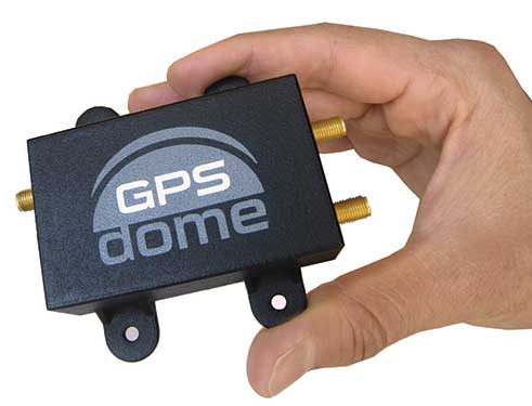
The national time system at Israel’s National Physics Laboratory (INPL) in Jerusalem is now protected by a GPSdome unit for cyber protection of GPS/GNSS signals, according to Israel’s Homeland Security, a private company established in 2012.
Microchip partner Focus Telecom installed the GPSdome cyber protection system under a support and maintenance contract. GPSdome was developed by infiniDome, an Israeli startup.
INPL’s Nadya Goldovsky will now test and measure the system for its ability to protect the GPS/GNSS satellite signals from jamming and other interference. Over the course of several months, Goldovsky will test the system’s ability to protect its four independent atomic clocks, which continuously supply Israel’s national time.
The cyber protection system is designed to enable continuous, uninterrupted GPS/GNSS service, which allows for full operation of the clocks. During a GPS cyber-attack, infiniDome’s Communication Module will report it to infiniDome’s Cyber Security Cloud.
“GPSdome is a cyber protection system developed based on military technologies and principals which was adapted to non-military, commercial use,” said Omer Sharar, infiniDome’s CEO. “Our systems are already deployed and operational in Israel at multiple sites in the defense/HLS sector, border protection, financial sector and telecom sector.”
The company has signed a global distribution contract with an international PNT solution provider to sell its GPSdome systems in more than 120 countries, Sharar said.
Dozens of parties cite evidence of harmful interference and vast economic harm that FCC ignored in favor of dubious 5G marketing claims
Dozens of private-sector interests will file Petitions for Reconsideration of the Federal Communications Commission’s (FCC) recent order to allow Ligado Networks to rezone its satellite spectrum holdings for terrestrial mobile use and “flip” them for a profit, according to the Washington, D.C.-based communications firm Glen Echo Group.
Petitioners will ask the FCC to reconsider its decision, which has generated widespread opposition within the administration, on Capitol Hill and from other aviation and satellite spectrum users. Petitioners include:
Airline Pilots Association
Association of Equipment Manufacturers
Aviation interests (including the Cargo Airline Association, the International Air Transport Association and Airlines for America)
Iridium Communications
Lockheed Martin
Trimble
RNT Foundation
The petitioners argue the FCC’s Order ignored or improperly disregarded the great majority of evidence, including technical analyses submitted by parties showing harmful interference, and relied instead on “easily disproven claims that Ligado will provide a so-called 5G service,” the Glen Echo Group stated in a press release.
“The L-band is not included in any internationally recognized 5G standard, the spectrum is not harmonized regionally or globally for 5G, FCC’s 5G FAST Plan does not include Ligado or L-Band spectrum nor does the company have enough contiguous spectrum,” the release stated.
Airlines for America. “Airlines for America (A4A) strongly supports a broad industry coalition that has led at least 32 U.S. Senators from both sides of the aisle to urge the FCC to stay and reconsider granting Ligado Networks’ petition to repurpose critical frequency spectrum for ‘5G’ terrestrial communications services. The FCC’s rushed order in April ignored testing protocols intended to protect critical users likely to be impacted, including aviation uses of Global Positioning Systems (GPS) for navigation, and satellite communications. Beyond industry opposition, the U.S. Department of Defense also strongly opposed the FCC’s action.
“A4A is joining other industry constituents in directly petitioning the FCC to reverse its course, the effects of which could impact the safety of the flying public and impact operations, especially harmful outcomes in the recovery period following the COVID-19 pandemic.”
Aerospace Industries Association. The association represents more than 300 companies.
“Uninterrupted access to GPS is essential not only for our industry, but also for the American people, our national security, and the strength of the U.S. economy. This access is now threatened by the FCC’s decision to grant Ligado Networks’ application, despite years of evidence and the concerns outlined by several federal agencies about potential interference. With this motion, we are banding together to urge the FCC to reconsider this decision and allow safety and data to drive their decision-making on spectrum.”
The International Air Transport Association (IATA), which represents some 290 airlines or 82% of global traffic said, “Approving Ligado’s spectrum for 5G poses a strong risk of interference with GPS signals, including the potential interruption of GPS signals at low altitudes. The FCC should reverse this decision.”
Air Line Pilots Association (ALPA). President Capt. Joe DePete said, “Throughout its report and order, the FCC uses words like ‘possible’ and ‘feasible’ when talking about whether Ligado can operate. These are not the words you would want to hear your Captain use when talking about successfully completing your flight the next time you are sitting in the cabin. Aviation requires certainty and guaranteed performance from its systems. The FCC’s hasty, arbitrary, and incorrect decision will set a disastrous precedent that will impede ongoing work on spectrum sharing. The Ligado decision must be reversed immediately.”
Aviation Spectrum Resources Inc. “In jointly filing a petition for reconsideration of the FCC’s recent decision on Ligado Networks’ proposal, ASRI joins the wider aviation community in expressing our view that the decision is based on a fundamentally flawed interpretation of the data that have been presented to the Commission. Among other deficiencies, the FCC’s decision ignores the FAA’s reservations cited by the Department of Transportation, having implications for many low-level aircraft operators including helicopters and UAVs. The FCC Order also seems to acknowledge the mounting evidence that aviation safety satellite communications will receive interference, but it relies on the completion of private negotiations to resolve these questions while giving Ligado a green light to proceed, rather than requiring specific mitigations itself. ASRI believes the FCC should revisit its decision in conjunction with aviation experts to ensure the safety of air transport, medivac and other essential aviation operators are not affected by this decision.”
Iridium Communications. CEO Matt Desch said, “The FCC’s Ligado action prioritizes economic windfalls to a few speculators over safety of life, national security and important private sector companies whose customers would be most upended by their harmful interference.”
RNT Foundation. President and Director Dana A. Goward said, “The FCC treated this like a commercial communications issue instead of a decision about safety-of-life navigation. They didn’t even consider the overall cost to the public in lost lives and property.”
In addition to private sector interests, 14 federal agencies and numerous Republican and Democratic members of Congress oppose the FCC’s decision in favor of Ligado.
Enhanced Oscilloquartz portfolio enables seamless transition to PTP timing from the core to the substation
Photo: Business Wire/Oscilloquartz
ADVA has upgraded its portfolio of Oscilloquartz PTP grandmaster clocks, enabling power utilities to smoothly transition to packet network synchronization.
The enhanced technology will empower electricity providers to evolve their infrastructure into smart grids based on precision time protocol (PTP) power profiles, while at the same time supporting all legacy timing signals.
Updates to ADVA’s Oscilloquartz pluggable solution, its compact small cell device, its mid-size PTP grandmasters and its fully redundant core timing technology ensure ultra-precise timing throughout a utility network.
The technology also removes the risk of relying purely on satellite-based time sources through continuous monitoring, jamming and spoofing detection and AI-assisted analytics.
ADVA’s entire range of Oscilloquartz grandmaster clocks has been upgraded to meet the latest PTP profiles for time, frequency and phase synchronization in power utility networks. This includes:
OSA 5401 small form-factor pluggable,
OSA 5405 for indoor and outdoor substation deployments,
OSA 5420 Series,
Highly scalable OSA 5430 and 5440 with 10Gbit/s interfaces and fully redundant hardware.
The technologies enable an easy migration to an Ethernet-based timing network with support for PTP, Network Time Protocol and SyncE, as well as IRIG-B, PPS and BITS legacy interfaces.
PTP-based backup combined with multi-band GNSS receivers and advanced monitoring capabilities ensure that the upgraded solutions provide highly reliable delivery of precise timing information even during long GNSS outages.
To create an ePRTC solution, ADVA’s Oscilloquartz cesium clocks can also be combined with the OSA 5420, 5430 or 5440. This delivers extended holdover of up to 70 nanoseconds for 14 days, even when GNSS signals are unavailable.
Particle — an edge-to-cloud internet of things (IoT) platform — is offering a new tracking system that allows organizations to track the locations of a wide variety of mobile assets.
Particle’s Tracker SOM (system-on-module) builds on its tracking services foundation. It provides a powerful GNSS, microcontroller and advanced peripherals in a compact form factor. Tracker SoM serves as an accelerated starting point for organizations that require a tailored tracking solution for sophisticated applications as well as a fully certified foundation for OEMs developing commercial products.
All of the company’s tracking solutions come with a high-gain GNSS antenna accurate to 1.8 meters.
A forthcoming study from Particle surveyed more than 1,000 IoT engineers and industry experts. Asset tracking was ranked as one of the top three most in-demand applications for IoT technology.
The asset tracking system is built on the Particle platform, spanning integrated internet-of-things (IoT) hardware, edge software, connectivity and cloud-based management software. The field-ready solution is configurable.
With it, customers can track the real-time location of critical assets and capture additional intelligence via sensor data including temperature and acceleration as well as remotely control mobile equipment and vehicles.
Research shows Internet of Things growing in use; free IoT maturity tool enables miners to measure readiness
Cover: Inmarsat
The latest research study conducted by Inmarsat, a global, mobile satellite communications company, found that the global mining sector is undergoing an internet of things (IoT) revolution with respondents reporting significant increases in adoption of connected technologies.
Inmarsat employed market research company Vanson Bourne to interview 200 respondents with either decision-making or influencing responsibilities for IoT-related initiatives at organizations of more than 500 personnel.
Mining organizations reported successes in implementing projects to safeguard workers via remote tracking, monitor drilling and observing acid mine-drainage remotely. However, despite this progress, a range of challenges are hindering the sector’s ability to reap the rewards IoT has to offer.
‘The Rise of IoT in Mining is the third IoT-focused research project undertaken by Inmarsat and focuses on the use of, attitude to and predictions for IoT across the global mining sector. As part of the initiative, Inmarsat is also offering mining companies the opportunity to measure their IoT readiness versus the 200 respondents to the survey, using their free online IoT maturity tool.
According to the research, most organizations (65%) have fully deployed at least one IoT project, while 33% are trialling or have trialled a project, with only 2% of respondents not having begun an IoT project.
These findings echo the predictions reported in Inmarsat’s 2018 mining research, where only 2% had fully deployed an IoT solution, 29% were trialling one and 69% were planning on beginning IoT projects within the next two years.
Noticeably, there is a considerable geographical variance in IoT adoption and maturity across different regions, with 98% of North American respondents having successfully deployed IoT-enabled projects, compared with only 50% in Africa and 38% in South America.
While this increase in full deployments represents progress, the use cases and data management are on the simple side and there are many challenges to overcome if the mining industry is to fully realise the potential of IoT, particularly in regard to using it as driver for organisational change.
A lack of skills, investment and cultural challenges, as well as unreliable connectivity, patchy cybersecurity processes and underdeveloped data management processes were also highlighted in the report and will all need to be remedied in the coming years.
“Two years on from our last research, Inmarsat wanted to get a measure of what had changed in the mining industry,” said Joe Carr, global mining director at Inmarsat. “IoT has begun to take a foothold in the sector with increased rates of adoption across the board. What we discovered was an industry that — historically slow to adopt radical ideas — is now beginning to embrace the use of IoT, but still working out how to make the most of it.”
The mining industry faces significant challenges around skills, security, connectivity, investment and data management. These will need to be addressed for the industry to progress past a point of using IoT in a simple, siloed capacity, according to the report.
Despite the challenges being faced, mining organizations are looking to increase their investment in IoT and are overwhelmingly positive about the value that IoT can bring to their operations and the benefits it is either already delivering or will deliver in the future.
“We want to help drive IoT adoption in the mining sector and encourage mining companies to plot a route to IoT success using our free online IoT Maturity Tool,” Carr concluded. “The tool allows miners to understand their progress in IoT adoption across a number of areas and to compare this with the 200 respondents who contributed to our research. Using these findings miners can start to develop a roadmap for improvement and provide a tangible proof point for influencing internal conversations.”