SPH Engineering has launched a new product to make bathymetric surveys of inland and coastal water.
The system — an unmanned aerial vehicle (UAV) integrated with an echo sounder — is time- and cost-efficient. It is suitable for mapping, measuring and inspecting tasks as well as environmental monitoring.
The system allows field workers to collect data with high accuracy quickly. It is easily transported, quickly deployed and twice as cost-efficient as traditional methods.
The UAV/echo sounder system can be operated in hard to reach locations, and unsafe or hazardous environments. Locations not reachable by foot or that are dangerous for a human (steep coasts, mining pits, contaminated waters, terrain obstacles, etc.) as well as waters of ponds, lakes, and canals can be reached by the drone.
“Since autumn 2018 we have been getting bathymetry-related requests,” said Lexey Dobrovolskiy, CTO of SPH Engineering. “Analyzing about 150 inquiries, we have come to the conclusion that a drone-based solution could open a new business opportunity for drone service companies to do bathymetry surveys of coastal and inland water, especially those for industrial needs.
“Compared with a standard approach using a boat or an unmanned surface vehicle, a drone could save a lot for its user,” Dobrovolskiy said. “An echo sounder itself could be integrated into a client’s drone with no need to purchase additional equipment. Moreover, it is small and easy to transport and operate. At the same time, such research method guarantees data accuracy and employee safety.”
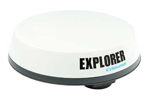
Cobham Explorer 323 and Explorer 6075LX terminals receive Inmarsat type approval
Two Cobham SATCOM land satellite terminals have received Inmarsat type approval. The low-profile vehicular Cobham Explorer 323 BGAN terminal and the auto-point “fly-away” Cobham Explorer 6075LX VSAT terminal are now fully operational on the Inmarsat network with commercial shipments of each beginning immediately.
Explorer-323. (Photo: Cobham)
The new Explorer 323 terminal represents the first class 12, electronically steerable terminal for use on Inmarsat’s L-band Broadband Global Area Network (BGAN). It combines the slimmest form factor of any vehicular BGAN terminal with a number of new innovative features and sets a new standard in robustness due to its lack of moving parts. In conjunction with Inmarsat’s highly reliable network, offering up to 99.9% uptime, it promises a new standard in mobile communications to organisations operating in remote locations across a wide array of industries.
The class 12 terminal features speeds of up to 384kbps, support for BGAN (data and voice) and BGAN M2M (data) operations, and an integrated antenna and receiver, meaning only a rooftop unit is needed. Additionally, the Explorer 323 has an integrated Wi-Fi Hotspot for setup, management and data access. Developed to integrate seamlessly with Cobham’s PRISM PTT+ offering, the Explorer 323 will enable telemetry and voice communications as well as other uses in remote rail operations, utilities, mining, aid and NGO operations, agriculture, public safety and emergency response.
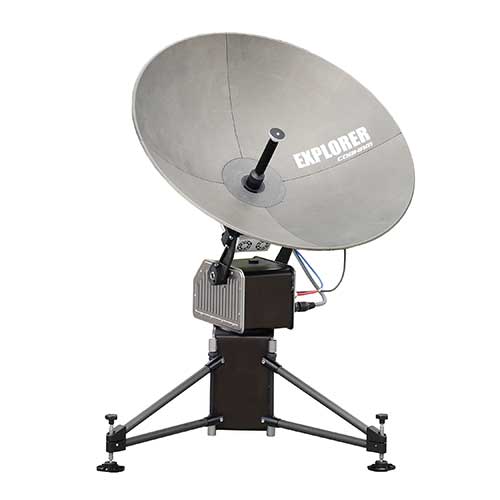
Explorer-6075. (Photo: Cobham)
Inmarsat has also approved the new auto-point ‘fly-away’ 0.75m Cobham Explorer 6075LX VSAT terminal for its high-speed Ka-band Global Xpress service. The new terminal offers the most reliable and stable connection in its class and features a simplified design, enhanced usability, quick setup and built-in WiFi. With a dynamic auto-pointing correction the terminal maintains its connection even in windy conditions or when pushed or moved, optimising its connection constantly. The Explorer 6075LX also features a considerable reduction in weight versus the Explorer 5075GX for greater portability and will support high-bandwidth applications in broadcasting, resilience and field-office operation.
“We are proud to offer these two game-changing terminals to our partners and customers,” said Mike Carter, president of Inmarsat Enterprise. “Their launch follows an important period of industry consultation, innovation and collaboration between Cobham and Inmarsat. With the Explorer 323 ideal for vehicular tracking and communications and the Explorer 6075 optimised for high-bandwidth operations, both terminals improve upon their predecessors and are set to make ultra-reliable connectivity easier to access in the remotest areas, wherever it is needed most.”
“These two new terminals from Cobham prove that there continues to be innovation occurring in both our L-band and Global Xpress networks,” said Todd McDonell, president of Inmarsat Global Government. “For government users, the 6075LX (or GX6075) provides a fast to set up, easy-to-use, automatic acquisition broadband terminal ideal for first responders who need to access communications at a scene quickly.
“In addition, the Explorer 323 provides government users with a way to maintain on-the-move connectivity regardless of the situation,” McDonell said. “When fixed networks become disabled or degraded, due to events such as natural disasters, the Explorer 323 provides an ideal, low-profile system for routing radio and data connectivity and can be integrated with the emergency services’ existing radio and data networks. We thank Cobham for bringing these products to market. We believe that they will help to deliver new capability for a number of government departments and agencies.”
Inmarsat owns and operates mobile telecommunications satellite networks around the globe, and holds a multi-layered, global spectrum portfolio covering L-band, Ka-band and S-band.
Inmarsat has provided global, L-band services for many decades, which are used by governments, the maritime and aviation industries, and commercial users on land, in sectors ranging from mining and agriculture to rail and transportation.
The frequencies used by Inmarsat to deliver these services are different to those used for GPS/GNSS. All terminals approved for use over Inmarsat’s L-band network (and their other networks) conform to international standards.
In the case of GPS, Inmarsat has exceed these standards by a considerable margin.
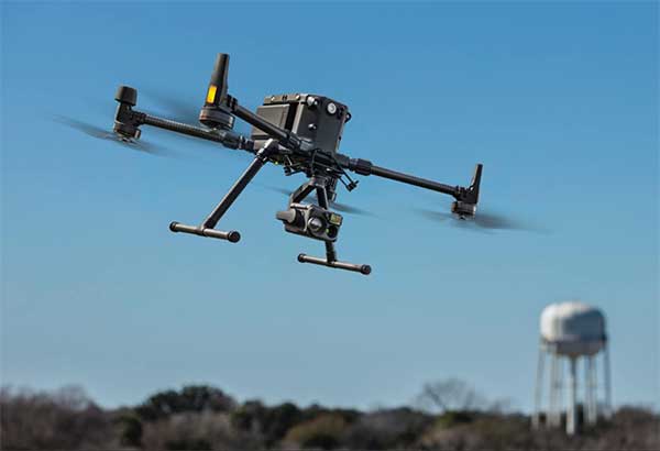
New Matrice 300 RTK and Zenmuse H20 series cameras ready for new generation of work, including digitalization and artificial intelligence (AI)
DJI has unveiled its most advanced commercial drone platform, the Matrice 300 RTK (M300 RTK), along with the Zenmuse H20 Series, a hybrid, multi-sensor camera.
The Matrice 300 RTK UAV from DJI is designed for the next level in data collection and site inspection. (Photo: DJI)
DJI engineered the all-in-one, high-tech solution for areas of work never explored before in precise aerial inspections and data-collection missions.
“With the M300 RTK flying platform and the Zenmuse H20 camera series, we are providing a safer and smarter solution to our enterprise customers” said Christina Zhang, senior director, Corporate Strategy at DJI. “This solution sets an entirely new standard for industrial UAV solutions, significantly enhancing operations across public safety, law enforcement, energy, surveying and mapping as well as critical infrastructure inspections.”
The M300 RTK is the first DJI product that integrates modern aviation features, advanced AI capabilities, six directional sensing and positioning system, a UAV health management system, and 55 minutes’ flight time.
The drone platform has AES-256 encryption and an IP45 weather-resistant enclosure. It has a built-in all-new OcuSync Enterprise transmission system that provides a triple-channel 1080p video transmission signal reaching up to 15 km away.
The M300 RTK can support up to 3 payloads simultaneously and has a maximum payload capability of up to 2.7 kg.
“For our teams working in the oil & gas industry, performance and safety are not optional,” said customer Adam Serblowski, Robotics Theme Lead at Shell. “We cannot compromise on our pursuit of utilizing the best and most efficient tools available. The DJI Matrice 300 RTK proves to be an ideal upgrade over the existing DJI product line, and it helps us to further enhance the benefits of our drone programs. Our productive partnership with DJI will continue to help elevate safety in the world’s largest industry.”
With the Zenmuse H20 Series Camera
Combined, the M300 RTK and Zenmuse H20 Series solution offers users two intelligent ways to collect data:
Smart Pin & Track. Intelligent functions that enhance synchronization of aerial intelligence in coordinated missions. It includes PinPoint, a function that allows users to mark the subject of interest and instantly share the precise location data to a second operator or if necessary to ground teams via DJI FlightHub; and Smart Track, which allows users to automatically detect and track a moving object, even at extreme distances, while synchronising the subject’s dynamic location in real time.
Smart Inspection. A new set of features developed to optimize routine data collection missions such as power lines, railway and oil and gas inspections. It consists of Live Mission Recording for recording sample automated missions in real time; AI-Spot Check, which enables data collection from exactly the same location every time, greatly improving the accuracy of automated missions. After photos from a sample waypoint inspection mission have been recorded, operators are able to mark the subject of interest. During subsequent automated flight missions, AI algorithms perform a comparison between the marked subject and current live view, thus correcting the camera orientation accordingly to deliver accurate and consistent results; and Waypoints 2.0 — an improved mission planning system offering up to 65,535 waypoints, while supporting an array of consecutive actions, 3rd party payloads, and more.
Aviation-Grade Situational Awareness. Inspired by today’s modern aircraft, the M300 RTK features a Primary Flight Display (PFD) that merges real-time flight and navigation data into one integrated display. Besides standard telemetry data like altitude and speed, the M300 RTK PFD provides obstacle data for visualising nearby obstacles during flight, enabling pilots to adjust flight trajectory if needed. These enhancements allow users to keep track of the aircraft while further enhancing the pilot’s situational awareness.
Dual-operator mode. New to DJI’s commercial drone platforms and exclusive to the M300 RTK, is Advanced Dual Operator Mode – multi-pilot control protocols that enable the execution of missions with enhanced safety, reliability and flexibility.
The M300 RTK, when controlled by two pilots, gives each pilot equal access to gain flight-control priority, the transfer of which is displayed by a series of icons on the DJI Smart Controller Enterprise. If one pilot becomes compromised or their controller loses battery or connection, the other pilot gains full control over the M300 RTK and its payloads.
When training new pilots, the teacher/main pilot can safely take over flight control if necessary.
Improved safety and reliability
The M300 RTK comes with new and improved safety and reliability enhancements, including:
AES-256 Encryption: for secure data transmission of the command & control uplink and video transmission downlink.
AirSense (ADS-B technology): for enhanced airspace safety.
Anti-Collision Beacon: for increased aircraft visibility, especially in low-light conditions.
IP45 Protection Rating & Self-Heating Battery: for adverse weather conditions (-20 to 50° C).
6 Directional Sensing and Positioning System: offers a maximum detection range of up to 40 m horizontally, with options to customize the aircraft sensing behavior via DJI Pilot.
As with modern-day jetliners, the M300 RTK offers an integrated UAV Health Management System (UHMS) to optimize fleet maintenance. It records the aircraft’s flight data throughout its entire lifecycle, and utilizes the drone’s hardware and software systems to understand current aircraft performance and determine when it should be serviced. Taking advantage of this new system, users can get a quick overview of all critical aircraft systems, manage firmware updates across an entire fleet, track pilot hours and review flight missions.
DJI Zenmuse H20 Series
The new camera payloads are designed to improve mission efficiency. The Zenmuse H20 series offers DJI’s first Hybrid multi-sensor solution, allowing capture of any kind of images for industrial applications and public-safety missions where efficient time management and immediate access to multiple layers of visions are paramount.
The H20 Series is IP44 rated, which protects enclosures from splashes of water from any direction.
The H20 series comes in two versions:
The H20, a triple sensor with a 20-MP, 23x hybrid optical zoom camera, a 12-MP wide camera, and a laser range finder covering distances from 3 to 1200 meters
The H20T, a quad sensor that adds a 640 x 512 radiometric thermal camera, allowing operators to see what is invisible to the human eye using high thermal sensitivity at 30 frames per second video definition.
Integrated user interface
To enable pilots to operate so many sensors at once, the accompanying DJI Pilot app interface was redesigned. The new user interface lets pilots quickly switch between cameras and simplifies the process of zooming in and out by letting pilots preview the zoom field of view on top of the wide angle or thermal camera footage.
With a multi-sensor integrated user interface, the Zenmuse H20 series allows users to smoothly switch between wide, zoom or thermal cameras. It also includes features for maximum flexibility when used on time-sensitive missions.
High-Res Grid Photo: Captures in one snap detailed imagery of defined subjects with the help of a custom grid. The images can be stored for later detailed inspection.
One-Click Capture: Captures videos or photos of up to three cameras simultaneously without having to manually switch between camera views or repeat a mission.
Night Scene: Gains clearer visibility when lighting conditions are not optimal.
The M300 RTK and Zenmuse H20 series are available for pre-order from official DJI Enterprise dealers and will start shipping in Q2 2020.
The U.S. Department of Transportation’s Federal Aviation Administration (FAA) announced the eight companies that will assist the federal government in establishing requirements for future suppliers of Remote Identification (Remote ID).
Remote ID will enable unmanned aircraft systems (UAS), commonly called drones, to provide identification and location information while operating in the nation’s airspace.
The FAA selected the following companies to develop technology requirements for future Remote ID UAS Service Suppliers (USS):
“The FAA will be able to advance the safe integration of drones into our nation’s airspace from these technology companies’ knowledge and expertise on remote identification,” said U.S. Transportation Secretary Elaine L. Chao.
This initial group will support the FAA in developing technology requirements for other companies to develop applications needed for Remote ID. The applications will provide drone identification and location information to safety and security authorities while in flight.
The technology is being developed simultaneously with the proposed Remote ID rule. Application requirements will be announced when the final rule is published. The FAA will then begin accepting applications for entities to become Remote ID suppliers. The FAA will provide updates when other entities can apply to become qualified Remote ID USS on FAA.gov.
Drones are a fast-growing segment of the transportation sector with nearly 1.5 million drones and 160,000 remote pilots now registered with the FAA. The agency’s ability to develop Remote ID technology simultaneously with the rule enables the FAA to continue to build on a UAS Traffic Management (UTM) system that has demonstrated global leadership through the small UAS rule and the implementation of the Low Altitude Authorization and Notification Capability (LAANC), which automates the application and approval process for most UAS operators to obtain airspace authorizations.
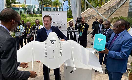
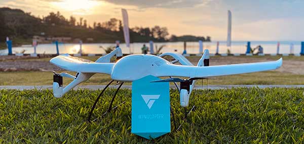
German drone manufacturer wins two prizes at renowned Lake Kivu Challenge in Rwanda
On May 5, the organizing committee of the Lake Kivu Challenge announced the results and named Wingcopter the winner of the Emergency Delivery category.
Wingcopter also received a special award for its safety procedures. As a winner, the company receives a prize money of GBP 65,000.
The Lake Kivu Challenge is a collaboration between the Government of Rwanda, the United Kingdom’s Department for International Development (DFID/UKAID), and the World Bank Group. The drone competition sought to demonstrate use cases for unmanned aircraft systems (UAS) on the African continent.
The challenge took place at the 2020 African Drone Forum in Rwanda in February — a first of its kind on the continent. Hosted by the Rwandan government and inaugurated by President Paul Kagame, the forum showcased advances in autonomous drone delivery — advances that can make a significant difference for isolated communities and rural areas across Africa.
Tom Plümmer, Wingcopter CEO, accepts the award from Rwanda’s President Paul Kagame. (Photo: Wingcopter)
The challenge received 92 applications from 35 countries. Only the top 10 drone companies were invited to put their drones and operators to the test through real-life scenarios at Lake Kivu in Western Rwanda.
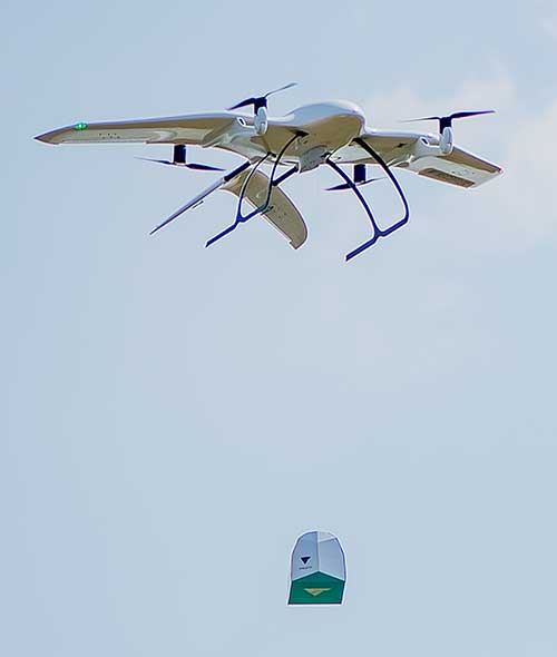
Throughout the three weeks of flights, Wingcopter was able to impress a panel of judges with perfect mission performance. This included fully automated delivery of an emergency package from a droneport on the mainland to Bugarura Island and a secure return landing.
The roundtrip, beyond-visual-line-of-sight-flight (BVLOS) was 40 kilometers and was completed without a battery swap. Wingcopter drones were able to complete the one-way route to the island within 12 minutes, a drastic reduction compared to more than 50 minutes by boat.
The package drop-off required no landing or human interaction, an attribute of Wingcopter’s innovative winch mechanism. Wingcopter had already successfully deployed a similar type of on-demand vaccine delivery to 19 remote villages in Vanuatu on behalf of the local Ministry of Health and supported by UNICEF.
The Wingcopter winch drop. (Photo: Wingcopter)
“We are very proud to be winners of the Lake Kivu Challenge, as this challenge and the African Drone Forum embody the innovative spirit of humanitarian aid and the African drone community as well as the great potential for sustainable drone deployments,” said Tom Plümmer, CEO and co-founder of Wingcopter. “We strongly believe that Wingcopter drones can leapfrog existing infrastructure by delivering significant social and economic value in Africa and beyond.”
“Wingcopter’s goal is to develop long-term partnerships with local governments, private sector and donor organizations throughout Africa,” added Selina Herzog, project manager at Wingcopter. “It is through these partnerships that we will accomplish the knowledge-sharing and training of the local workforce, ultimately empowering local stakeholders to take over and scale operations. We want our technology to give back to the communities where we operate and create new perspectives.”
The African Drone Forum created a unique platform to tell the Wingcopter story and exhibit its technology to more than 1,000 key players within the international drone and humanitarian ecosystem, allowing immense networking opportunities with the potential for future partnerships and business deals. An initial memorandum of understanding with a Rwandan startup has already been signed; others will likely follow.
Wingcopter recently announced a commercial partnership with UPS Flight Forward to jointly develop the next generation of package delivery drones. The combination of UPS’ experience in logistics and its global network with Wingcopter’s contactless drone delivery technology will put the two companies in a better position to contribute to the fight against the COVID-19 pandemic. Wingcopter is preparing multiple coronavirus-related projects.
Wingcopter on Bugarura Island. (Photo: Wingcopter)
With more than 3 million people infected around the world, the coronavirus pandemic is pushing health authorities to research and develop new ways to react to critical situations, according to drone company Quaternium.
Public and private organizations are racing to develop experimental treatments and vaccines to fight COVID-19. At the same time, many local companies are trying to think outside the box to find ways to minimize the effects of the crisis. “Our current situation has opened up opportunities for innovative solutions, and we are best seeing them within the drone industry,” said Alicia Fuentes, CEO at Quaternium.
Photo: Quaternium
Drones have been deployed in the effort to contain the spread of the pandemic. “We’ve seen drones distributing public information, like voice messages, to those not following social distancing measures as well as delivering medical samples and spraying disinfectants to urban areas,” Fuentes said.
Unmanned solutions are easy to operate and can be quickly mobilized. “In addition to reducing the risk of health of sanitary workers, drones also get to unreachable places; they have become a versatile tool for managing this health catastrophe,” Fuentes said.
In Europe, several startups like Quaternium, Drone Tools and Manna Aero, and in the U.S. and Canada, companies such as Zipline and Draganfly are all exploring how they can help in their regions and neighboring countries to decrease the aftermaths of the pandemic and save more lives.
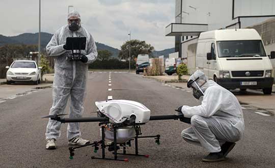
Quaternium demonstrates drone spraying
Quaternium has successfully been testing its hybrid drone, HYBRiX, to spray disinfectant products in Spain, showing how drone technology may serve in critical situations and how the company can support public authorities to help end the spread of the virus.
The company has also demonstrated aerial logistics solutions by delivering essential items to people in critical situations. Long-endurance drones can deliver supplies specifically for COVID-19 efforts, such as masks and gloves to first responders. HYBRiX can also deliver medicine to patients who can’t safely get to a pharmacy.
In the U.S., police departments are using drones from Impossible Aerospace to limit personal contact and share COVID-19 information, to reach out to homeless people (who are particularly at risk for coronavirus) and to monitor and enforce social distancing.
These are some of the areas where drones are being used to fight COVID-19.
Delivery drones
Due to COVID-19 being so contagious, it’s safer if human-to-human contact is minimized. UAVs are proving to be a valuable tool when delivering medical samples and essential items to health personnel. Several drone companies have made tests showing the crucial role that unmanned logistics can play against the spread of COVID-19.
Inform and prevent
“In the last weeks, we have seen speakers being mounted on drones to help inform people outdoors and prevent public gatherings. Drones can also be found flying with banners advising people on how to be more precautious when going outside,” Fuentes said. The mobility and flexible use of these UAVs make the mission of security agencies simpler, while avoiding close contact with the population, she said.
Aerial spraying and disinfection
First in China and now in Europe and the U.S., agriculture drones — originally designed to spray liquids on crops — are being adapted to spray disinfecting chemicals in public spaces and impacted areas. Experts have discovered that coronavirus is mainly transmitted by touching contaminated surfaces. This new virus has shown to be very contagious and resistant, staying on some surfaces up to 30 days, which makes disinfectant spray vital to helping reduce transmission mechanisms.
The battle with COVID-19 has just begun. Cases are continuing to rise in and outside of Europe. “Now more than ever, public authorities and private companies need to join forces in order to grow stronger and overcome this pandemic together,” Fuentes said.
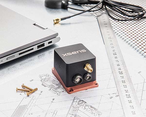
Xsens, manufacturer of motion-tracking modules, has launched real-time-kinematic (RTK)-compatible motion trackers. The development is designed to bring centimeter-accurate positioning within reach of a new generation of affordable commercial devices.
The RTK extension to conventional satellite positioning signals reduces the maximum positioning error from around ±1 meter in standard commercial GNSS receivers to typically ±2 centimeters. Companies developing innovative new products in non-military markets such as smart farming, autonomous vehicles and coastal maritime equipment have been keen to take advantage of high-precision RTK capability to enable new applications and more automated functions, according to an Xsens press release.
The MTi-680G is a new product in the Xsens MTi 600-series. The MTi-680G, an integrated GNSS/inertial navigation system (INS) module, features an integrated RTK GNSS receiver, as well as providing synchronized 3D attitude (tilt, inclination) and heading outputs.
The new MTi-680G also features upgraded firmware that substantially accelerates the module’s internal signal processing compared to non-RTK modules. Synchronizing the global position coordinates with the module’s attitude, heading and velocity outputs, the MTi-680G can provide a comprehensive positioning and navigation output for any carrier device, including of devices such as drones that move at high speed, at a maximum output data rate of 400 Hz.
The RTK-enabled module also offers these features:
Precise factory calibration of every production unit
High immunity to magnetic interference
Adaptive firmware operation to optimize performance in various types of scenario
Easy-to-use, free MT Software Suite developer tools to accelerate integration into end-product designs
Out-of-the-box operation with Xsens’ MTi development kits
“Centimeter-accurate positioning at an affordable price for commercial applications — this is the promise of the new RTK-compatible MTi-680G product,” said Boele de Bie, Xsens CEO. “From seed-sowing agricultural robots to autonomous cargo ships, a whole new generation of applications is now possible thanks to the centimeter-level accuracy of the MTi-680G’s position measurements.”
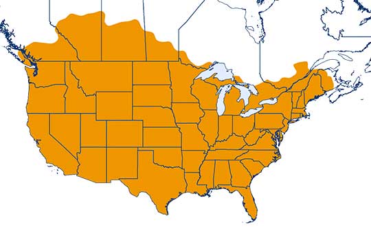
One-inch GNSS accuracy in under a minute, delivering seamless high-precision performance across the U.S. and southern Canada
Trimble has completed expanding its CenterPoint RTX Fast correction service, with coverage now spanning the contiguous U.S. and southern Canada. This expansion is central to Trimble’s vision to transform how and where users can leverage precision and accuracy.
Coverage of Centerpoint RTX Fast. (Image: Trimble)
Designed for autonomous applications in both on-road and off-road markets, the coverage and performance of the service enables industry professionals to re-think what is possible when using augmented positioning for improving safety, performance, productivity and operational efficiency.
The CenterPoint RTX Fast subscription service delivers horizontal positioning accuracy of 1 inch (2 centimeters) or less in under a minute, with the versatility of satellite or cellular delivery. This expanded coverage makes it the largest, high-performance GNSS correction network in the world, according to Trimble.
Base stations not required. The service encompasses more than 5 million square miles across North America and Europe. By using the service, said Trimble, farmers, land surveyors and GIS professionals can untether from the cost and complexities of GNSS base stations.
In addition, Trimble RTX Fast offers a single, continuous correction technology platform for enabling a broad range of safety-critical autonomous applications in markets such as automotive, agriculture and construction.
“This achievement is a major milestone in the continuous evolution of our correction service and autonomy strategy. We are delivering unmatched access to fast, reliable, highly accurate positioning in more areas than ever before,” said Patricia Boothe, senior vice president of Trimble’s Autonomy Sector. “Whether enhancing performance in the autonomy ecosystem or simplifying traditional mapping and surveying workflows, RTX Fast users can gain greater accuracy to improve productivity and operate safely — ultimately transforming the way they work and drive.”
CenterPoint RTX Fast subscriptions for Trimble RTX-compatible GNSS receivers are available through Trimble’s Authorized Business Partners or Trimble’s online store.
The warranty comes about as a result of very low observed failure rates over the company’s 10-year history and its ongoing quality initiatives.
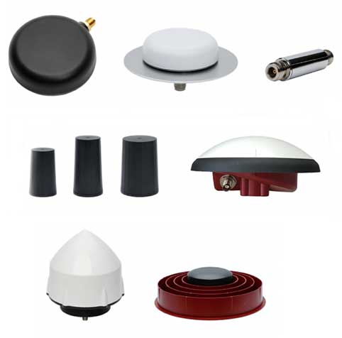
Tallysman Wireless is a leader in the GNSS antenna design and manufacturing industry. Tallysman offers a wide range of GNSS antenna elements, which includes accurate, low-profile ceramic patch (Accutenna), lightweight helical, high-efficiency Alfred loop (VeroStar) and precise cross dipole (VeraPhase and VeraChoke) technology antennas. All housed versions of these antennas are covered in the new standard three-year warranty.
Also included in the warranty period is the Tallysman line of radio-frequency accessories that includes low-noise inline amplifiers; compact, low-loss signal splitters; and power-regulated bias tees.
The standard warranty does not cover environmental hazards, such as lightning strikes, and abuse, such as physically damaged housings, ripped connectors and cables, normal corrosion, and wear and tear.
Qinertia, SBG Systems’ PPK software, now supports third-party IMUs and offers a GNSS post-processing license covering all major GNSS receivers
Screenshot: SBG Systems
SBG Systems’ INS/GNSS post-processing kinematic (PPK) software Qinertia now covers all surveyors’ projects by offering a license dedicated to GNSS post-processing. Open to the world, Qinertia supports all major GNSS receivers and is now open to third-party inertial measurement units (IMUs).
Qinertia has been designed to offer a comprehensive suite of post-processing software to geospatial professionals. It accepts all major GNSS manufacturers, and supports proprietary protocols from NovAtel, Septentrio, Trimble and u-blox for a straight-forward workflow.
The full-featured post-processing software offers native support for u-blox F9 real-time kinematic (RTK) receivers, reducing the workflow to a simple “drag and drop” to guarantee data integrity and accuracy.
Qinertia has been designed to help surveyors get the most of their surveys easily with a simple workflow, powerful quality control tools and tightly coupled algorithms. All of this is available to any surveyor with the new support of third-party IMUs or GNSS receivers. Several IMUs and inertial navigation systems (INS) have already been successfully integrated with Qinertia including Northrop Grumman’s LN-200 and LCI-100 and the Inertial Sense µIMU.
The new Qinertia GNSS license allows surveyors to post-process both static and kinematic GNSS data. In just a few clicks, surveyors can improve their trajectories, access RTK corrections worldwide, or even control a base-station’s precise location using precise point positioning (PPP) static computations.
GIS and Photogrammetry. Whether they fly a UAV or drive a car, professionals can improve their image location accuracy. Qinertia has been designed to help surveyors get their GIS or photogrammetry projects way more precise, by exporting a centimetric position for each picture at the exact shutter event.
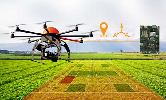
A new high-performance compact GPS/GNSS receiver with an on-board IMU sensor, tailored to the needs of UAV applications
Septentrio has released a new GNSS/INS receiver, the AsteRx-i D UAS. This multi-frequency receiver combines reliable centimeter-level positioning with 3D orientation, enabling automated navigation of aerial drones and robots.
GNSS signals received include the American GPS, European Galileo, Russian GLONASS, Chinese BeiDou, Japan’s QZSS and India’s NavIC.
With a high-performance IMU (inertial measurement unit) from Analog Devices integrated directly into the receiver board, AsteRx-i D UAS is compact and lightweight. Aboard the drone, its small form-factor combined with exceptionally low power consumption results in extended battery life and longer flight times.
“With this product we introduce into our inertial-GNSS portfolio an IMU which allows us to reduce the weight and power consumption of our UAS boards while making them easier to integrate. These are all key elements for a successful UAV platform.”
AsteRx-i D UAS is the first commercial product resulting from Septentrio’s collaboration with Analog Devices, delivering robust positioning and attitude (heading, pitch and roll) in demanding industrial environments. Both single-antenna and dual-antenna versions are available.
The single-antenna version provides a lightweight solution optimizing the system SWaP (size, weight and power). The dual-antenna version is designed for machines that need reliable heading directly from the start.
AsteRx-i D UAS comes with Septentrio’s Advanced Interference Mitigation (AIM+) technology. In aerial drones, where many electronics are crammed into a small space, neighboring devices can emit electromagnetic radiation, interfering with GNSS signals. AIM+ offers protection against such interference resulting in faster set-up times and robust continuous operation.
The on-board IMU from Analog Devices is exceptionally robust against mechanical vibrations. This IMU combined with Septentrio’s anti-shock LOCK+ technology makes AsteRx-i D UAS resilient against impact during takeoff and landing.
The AsteRx-i D UAS evaluation kit is now available in Septentrio’s online shop, which offers direct access to the company’s latest GNSS technology. For more information, contact [email protected].
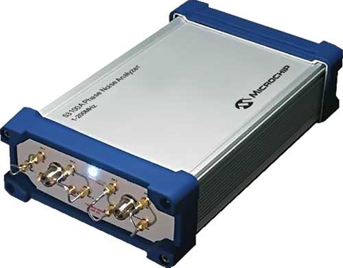
Next-generation phase noise instrument combines timing technologies in a smaller, higher performance measurement instrument
Photo: Microchip Technology
To help research and manufacturing engineers make precise and accurate measurement of frequency signals, including those generated by atomic clocks and other high-performance frequency reference modules and subsystems, Microchip Technology Inc. has announced the availability of the new 53100A Phase Noise Analyzer, a next-generation phase noise test instrument.
The 53100A Phase Noise Analyzer is designed for engineers and scientists who rely on precise and accurate measurement of frequency signals generated for 5G networks, data centers, commercial and military aircraft systems, space vehicles, communication satellites and metrology applications.
Capable of measuring radio frequency (RF) signals up to 200 MHz, the new test instrument rapidly acquires frequency signals and characterizes the phase noise, jitter, Allan deviation (ADEV) and time deviation (TDEV) quickly and precisely. All attributes of a frequency reference can be completely characterized with a single instrument within minutes.
The 53100A Phase Noise Analyzer enables a variety of configurations by allowing up to three separate devices to be tested simultaneously using a single reference, enabling higher capacity for stability measurements. At 344 x 215 x 91mm (13.5 x 8.5 x 3.6 inches), the phase noise test instrument is small enough for integration into manufacturing automated test equipment (ATE) systems, yet powerful enough for laboratory-grade metrology. Its interface provides backward compatibility with Microchip’s 51xxA test sets’ command and data stream, reducing the need to redesign existing ATE infrastructure.
The 53100A Phase Noise Analyzer provides flexibility by allowing an input reference device to be connected through the front panel at a different nominal frequency than the device under test — allowing a single reference to characterize a variety of oscillator products. Rubidium frequency standards such as Microchip’s 8040C-LN or a quartz oscillator such as Microchip’s 1000C Ovenized Crystal Oscillator (OCXO) could be used as a reference as well as other manufacturers’ precise oscillators.
The 53100A Phase Noise Analyzer is available now. Microchip supports the 53100A Phase Noise Analyzer with technical support services as well as an extended warranty.