The U.S. Air Force has released the 5th Edition of the GPS Standard Positioning System (SPS) Performance Standard (PS), according to U.S. Coast Guard Navigation Center (NAVCEN) Civil GPS Service Interface Committee (CGSIC).
With final signature by the U.S. Department of Defense, the standard was cleared for public release on April 16. This is the first update to the SPS PS since 2008 and, for the first time, includes pre-Initial Operating Capability (IOC) performance standards for new civil GPS signals L2C and L5, in addition to L1 C/A.
The SPS PS specifies the levels of SPS performance in terms of broadcast signal parameters and GPS constellation design. According to NAVCEN, the U.S. government is committed to meeting and exceeding the minimum levels of service specified in the SPS PS.
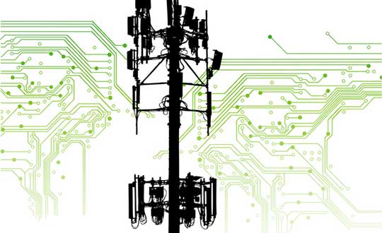
The five-member Federal Communications Commission (FCC) voted unanimously to approve an order to allow Ligado Networks to deploy a low-power nationwide 5G network.
The approval comes despite objections from the U.S. Defense Department (DOD), other federal agencies and major U.S. airlines, all of whom are concerned about near-band interference with GPS.
The FCC said the approval order included stringent conditions aimed at ensuring GPS would not experience harmful interference.
“After many years of consideration, it is time for the FCC to make a decision and bring this proceeding to a close,” said FCC Chairman Ajit Pai in an April 16 news release. “We have compiled an extensive record, which confirms that it is in the public interest to grant Ligado’s application while imposing stringent conditions to prevent harmful interference.”
Ligado is seeking to repurpose a swath of L-band spectrum for a 5G network focused mainly on connecting smart devices and other internet-of-things services. According to the FCC, the order will “promote more efficient and effective use of our nation’s spectrum resources and ensure that adjacent band operations, including the Global Positioning System (GPS), are protected from harmful interference.”
In response, members of both the Senate and House Armed Services Committees and other defense advocates are considering legislative action to overturn the order.
Two areas that rely heavily on the integrity of GPS signals include defense and transportation. The DOD issued a joint statement with the Department of Transportation (DOT) criticizing the FCC ruling.
“Americans rely on our Global Positioning System (GPS) each day for many things: to locate citizens in need of emergency assistance through our E-911 system, to secure our financial system, to order and receive shipments, to travel by car for work and leisure, to facilitate commercial trucking and construction work, and even to make a simple cellphone call. Our departments rely on GPS each day for all those reasons as well to coordinate tactical national security operations, launch spacecraft, track threats, and facilitate travel by air and sea. The proposed Ligado decision by the Federal Communications Commission will put all these uses of GPS at risk.”
House Armed Services Committee Chairman Adam Smith (D-Wash.) released a letter he sent to Defense Secretary Mark Esper and FCC Chairman Ajit Pai raising concerns about Ligado’s 5G network.
“While the United States must be a leader in the implementation of 5G networks, our creation of these networks must not hamper our military’s operational capacity in any way. China’s aggressive, global promotion of its 5G companies presents a considerable security challenge that must be addressed. However, Ligado’s proposal, which seeks a portion of spectrum adjacent to that used for Global Positioning Systems, poses an even larger security risk.
“The Department of Defense has been clear and direct: providing this license to Ligado would cause unacceptable operational impacts and adversely affect the military’s use of GPS. The military’s seamless use of GPS is vital to our national security. Our service members rely on GPS satellites for critical precision timing and navigation, and thousands of weapons systems are embedded with GPS signals.
“While I strongly support development of the world’s most robust, safe and secure network, using L-band spectrum in such close proximity to critical GPS, as Ligado’s proposal requires, carries an unacceptable risk that far outweighs the possibility of a 5G network.”
‘Risk of crippling’ GPS
Defense Secretary Mark Esper said via Twitter on Friday that the “Ligado proposal would needlessly imperil GPS-dependent national security capabilities. The Department continues to support domestic 5G options, but not at the risk of crippling our GPS networks. Nearly a dozen other federal agencies have joined us in opposing this proposal.”
“Although I appreciate the concerns that have been raised by certain Executive Branch agencies, it is the Commission’s duty to make an independent determination based on sound engineering. And based on the painstaking technical analysis done by our expert staff, I am convinced that the conditions outlined in this draft order would permit Ligado to move forward without causing harmful interference. For example, the draft order would authorize downlink operations at a power level that represents a greater than 99% reduction from what Ligado proposed in its 2015 application.”
Image: A-Digit/DigitalVision Vectors/Getty Images
The release also provided this background about the Ligado proposal, and the “conditions” under which the FCC decided to approve it.
In recent years, Ligado has amended its application to significantly reduce the power levels of its base stations from 32 dBW to 9.8 dBW (a reduction of 99.3%). Ligado has also committed to providing a significant (23 megahertz) guard-band using its own licensed spectrum to further separate its terrestrial base station transmissions from neighboring operations in the Radionavigation-Satellite Service allocation. As such, Ligado is now only seeking terrestrial use of the 1526-1536 MHz, 1627.5-1637.5 MHz, and 1646.5-1656.5 MHz bands. The Order is conditioned to reflect these technical requirements. It also requires Ligado to protect adjacent band incumbents by reporting its base station locations and technical operating parameters to potentially affected government and industry stakeholders prior to commencing operations, continuously monitoring the transmit power of its base station sites, and complying with procedures and actions for responding to credible reports of interference, including rapid shutdown of operations where warranted.
However, The decision “appears to ignore the well-documented views of the expert agencies charged with preserving the integrity of GPS, specifically on the critical issue of what constitutes harmful interference to users of Global Navigation Satellite Systems (GNSS),” said J. David Grossman, executive director of the GPS Innovation Alliance (GPSIA). He continued,
J. David Grossman
“GPSIA has consistently advocated for adoption of the 1-dB Standard as the only reliable mechanism that provides the predictability and certainty to ensure the continuation of the GPS success story, with the support of the Department of Defense, the Department of Transportation and numerous other federal agencies. The 1-dB Standard for radiofrequency-based services is critical for GNSS. The FCC’s press release refers to conditions placed on Ligado’s application to prevent harmful interference, and GPSIA and its members intend to carefully review the details of today’s order while continuing to vigorously advocate for promoting, protecting and enhancing GPS.”
Ligado Networks President and CEO Doug Smith issued this statement in reaction to the approval.
“Ligado thanks the Commissioners for moving promptly to approve the order regarding our applications. We greatly appreciate their unanimous support as well as the expert engineering analysis determining that a terrestrial network can be deployed in the L-band to advance our country’s economic and security interests while fully protecting GPS. Our spectrum can be very instrumental in the transition to 5G, and we look forward to utilizing satellite and terrestrial services to deploy customized private networks and deliver innovative, next-generation IoT solutions for the industrial sector.”
Positive reactions to the decision
On April 20, the FCC released a compilation of responses to the decision, all of them in support.
Attorney General Bill Barr: “I applaud FCC Chairman Pai’s proposal to make available L-band spectrum, to be used together with C-band spectrum, for deployment of advanced wireless services, including 5G. As I said in my speech at the Center for Strategic and International Studies, swift FCC action on spectrum is imperative to allow for the deployment of 5G. This is essential if we are to keep our economic and technological leadership and avoid forfeiting it to Communist China.” (Statement, 4/16/2020)
Secretary of State Mike Pompeo: “I commend Federal Communications Commission (FCC) Chairman Pai’s draft order that would release the L-Band spectrum. Quick action on this order, in conjunction with the allocation of a portion of the C-Band for 5G, is vital to our national security and will help ensure that the United States is the global leader in advanced technologies such as AI, the Internet of Things, edge computing, and the next generation of telemedicine. Accelerating the deployment of 5G is essential to our country’s growth, and global economic security.” (Statement, 4/16/2020)
Sen. Ron Johnson (WI): “In a time when connectivity is and will continue to be more important than ever, it’s great to see @AjitPaiFCC move forward with freeing up critical spectrum resources for #5G.” (Tweet, 4/16/2020)
Sen. Mark Warner (VA): “As the U.S. works to lead the world in 5G innovation and promote wider high-speed internet coverage, it’s all the more important to put our valuable mid-band spectrum to use. I urge the @FCC to follow the Chairman’s lead and approve Virginia-based @LigadoInsights’s application.” (Tweet, 4/16/2020)
Rep. Billy Long (MO): “I applaud @AjitPaiFCC and the @FCC for taking action to unlock vital L-band spectrum that has been held hostage by bureaucratic slow-walking for far too long. Jobs and 5G is a win-win for the country.” (Tweet, 4/16/2020)
Rep. Doris Matsui (CA): “I called on the @FCC to move forward with new, innovative uses of L-band spectrum to advance 5G. Glad to see the Commission take action on this front today to encourage efficient use of our spectrum.” (Tweet, 4/16/2020)
Former Rep. Bob Barr (GA): “Federal Communications Commission Chairman Ajit Pai’s decision to circulate a draft FCC Order would at long last move forward the process of opening up a segment of mid-band satellite spectrum for commercial use in 5G technology deserves praise. … If adopted by the five-member Commission headed by Pai, the draft Order would tangibly signal to the country and the world that the United States is committed to seize the leadership in deployment of 5G technology, a role China openly covets.” (Statement, 4/16/2020)
American Action Forum: “More good news from the FCC! 5G is incredibly important and this is yet another example of actions that will enable innovation in 5G and support the growing number of connected devices.” (Tweet, 4/16/2020)
American Enterprise Institute Visiting Scholar Mark Jamison: “@FCC approval of Ligado petition should accelerate 5G, bring diversity to marketplace, and increase efficient spectrum use. … Good leadership and bipartisan effort!” (Tweet, 4/20/20)
American Enterprise Institute Visiting Scholar Roslyn Layton: “Kudos @AjitPaiFCC for unlocking more vital mid-band spectrum for #5G. Record of 10 years shows @LigadoNetworks took many steps with agencies and firms to address potential issues with GPS. We must move quickly on 5G!” (Tweet, 4/16/2020)
Citizens Against Government Waste: “The FCC has the engineering expertise to determine the best use of this spectrum and whether alternative uses would cause undue interference. The adoption of the Chairman’s draft order will promote 5G and IoT development, while providing the necessary safeguards for services using adjacent bands, including GPS positioning. … The L-band would not be used at all for the foreseeable future unless the FCC takes action. Freeing up the spectrum requested by Ligado will not only expand the use of 5G, it will also help to prevent other countries, particularly China, from getting ahead of the U.S. in 5G deployment.” (Blog, 4/17/2020)
Competitive Carriers Association: “[We] commend Chairman Pai for circulating a draft order to approve Ligado’s applications, which will make much-needed mid-band spectrum, specifically L-band spectrum, available for terrestrial use. This long-awaited, positive progress comes at a critical time for all Americans, particularly those in rural areas, who are relying on mobile connections and services more than ever before. Mid-band spectrum provides real opportunities for deploying next-generation technologies, and competitive carriers are eager to access this valuable resource to expand and enhance their networks.” (Statement, 4/16/20)
Competitive Enterprise Institute: “Access to spectrum is crucial for our modern economy, connecting everything from radios, to cellphones, to satellites. But for too long, turf-wars between federal regulatory agencies have left spectrum bands largely unavailable for valuable commercial applications. Today’s FCC decision wrests spectrum away from bureaucratic waste and delivers it into the hands of people who will aide our economic recovery and resiliency in the aftermath of the COVID-19 pandemic.” (Statement, 4/16/2020)
CTIA—The Wireless Association: “We’re pleased to see that the FCC has managed to cut through the red tape to make a decision on Ligado. This multi-year process reveals the challenges at play in our nation’s spectrum policy and the need for stronger support for new commercial wireless services. We need to all learn lessons from this process and ensure that decisions on key spectrum bands like lower 3 GHz occur in a more expedited and collaborative manner.” (Statement, 4/16/2020)
FreedomWorks: “Freeing up broadband spectrum will make America a global technological leader and will lead to innovations and developments that will improve quality of life across the country. Chairman Pai and the FCC should be applauded for their work resolving these matters[.]” (Blog, 4/15/2020)
Free State Foundation: “Chairman @AjitPaiFCC has made a commendable decision to act on @LigadoNetworks’ proposal to put L-band spectrum into use for next-gen wireless services. This move takes seriously the @FCC’s responsibility and the urgent need for more commercial spectrum.” (Tweet, 4/16/2020)
Georgetown Law Institute for Technology Law & Policy Distinguished Fellow Gigi Sohn: “This decision was a long time coming, but it’s the right one. … Kudos to @AjitPaiFCC for having the fortitude to move this forward.” (Tweet, 4/16/2020)
Information Technology & Innovation Foundation: “Great to see @FCC taking steps to finally approve @LigadoNetworks waiver for terrestrial use of their spectrum. This will be a boon to industrial IoT connectivity, bringing more productivity, safety, and resiliency for users of the network.” (Tweet, 4/16/2020)
International Center for Law & Economics: “Promoting deployment of 5G & next-gen IoT devices means finding new ways for incumbents to responsibly operate in ever-closer proximity. The @FCC’s Ligado order does that. Credit to @AjitPaiFCC for finding a way fwd that promotes innovation while limiting the risk of interference.” (Tweet, 4/16/2020)
Lincoln Network: “Access to spectrum is an essential feature in any working 5G plan. Frankly, one key barrier in opening up this vital resource is government’s stronghold on ‘beachfront’ spectrum whether they own it or not. … This proceeding has been in regulatory limbo for several years due in large part to government stakeholders’ speculative interference claims regarding GPS-applications. … The FCC’s draft order in this proceeding provides enough protection for incumbents in adjacent bands, adds more competition into the 5G-IoT space, and allows consumers to have more access to broadband. Everybody wins.” (Blog, 4/16/2020)
Mercatus Center Senior Fellow Brent Skorup: “Too often new tech is stalled by FCC regulation and incumbents. Chairman Pai pledged to breathe new life into Sec. 7. It’s great to see Chairman Pai and the FCC act on that pledge, liberalize spectrum, and expedite the deployment of new wireless services.” (Tweet, 4/16/2020)
National Security Institute: “Big move by @FCC Chairman @AjitPaiFCC today to support US 5G availability. This is a key nat sec issue w/ threat posed by China + econ benefits of broad 5G deployment in US.” (Tweet, 4/16/2020)
New America Foundation’s Open Technology Institute: “Kudos to @AjitPaiFCC @FCC for again standing up to Fed agencies trying to hoard spectrum they are not using – or, in this case, which is licensed to @LigadoNetworks! A big plus for #5G wireless ecosystem if it’s built out.” (Tweet, 4/16/2020)
R Street Institute: “If you can change your business model to be more productive and profitable, without hurting anyone else, then regulations shouldn’t stand in your way. Well done, @FCC!” (Tweet, 4/16/2020)
Progressive Policy Institute: “We applaud the FCC’s ongoing efforts to accelerate the deployment of 5G. Repurposing this commercial spectrum for a mobile broadband network is another step in the right direction.” (Tweet, 4/16/2020)
Public Knowledge: “The Chairman’s proposed Order reveals how the FCC has worked to both protect incumbent GPS users while allowing for pro-competitive commercial licensing of spectrum. … Congress has entrusted the FCC to strike the proper balance between the needs of incumbents and the potential benefits to new entrants or new users, and here, the FCC gets it right. In approving Ligado’s license, the FCC has taken an important step forward in its role as the sole arbiter of spectrum disputes and, in this instance, has correctly sided on behalf of the public interest to help deliver the potential of 5G to more Americans.” (Statement, 4/16/2020)
Technology Policy Institute: “Allowing the Ligado spectrum to lie fallow would represent a waste of valuable resources that could provide substantial benefits for consumers in the form of new Internet of Things and other uses. … Failure to approve the Ligado license modifications would have the opposite effect, transferring a large block of spectrum from the commercial sector back to the government. The Commission’s action today will avoid that outcome.” (Statement, 4/16/2020)
Wireless Infrastructure Association: “WIA applauds Chairman Pai for circulating a draft order to approve Ligado’s plans to deploy a nationwide network that would primarily support 5G and IoT services. After years of diligence, study, and discussion, today’s action is further evidence that the FCC bases its decisions on science and engineering. Freeing up more spectrum, especially mid-band spectrum, is vital to 5G deployment. Ligado’s proposal offers an enormous opportunity for infrastructure investment, deployment, and connectivity for Americans across the country right when we need it most.” (Statement, 4/16/2020)
The National States Geographic Information Council (NSGIC) has released a joint statement on the value of GIS during the COVID-19 pandemic, alongside its partners the MidAmerica GIS Consortium (MAGIC), Open Geospatial Consortium (OGC), Urban and Regional Information Systems Association (URISA), and American Association of Geographers (AAG).
Joint Statement on the Value of GIS in the Pandemic
The spread and effects of COVID-19 can be best understood considering space and time.
As governments are responding to COVID-19, more leaders are recognizing the value of “knowing the where.” The importance of knowing where the outbreak is growing, where high risk populations are, where the hospital beds and important medical resources are, and where to deploy resources is essential. “Knowing the where” informs better decision-making.
In an effort to better understand the where, governments are recognizing the value of geospatial information and technologies and are engaging geospatial professionals to help them better understand the where to help them in their decision-making and response.
Geospatial professionals bring unique analytical and visualization skills to the table that help responders and decision-makers visualize where the pandemic is spreading more quickly and can make the important decisions regarding where response and resource needs need to be focused. The value of telling the story through a map coupled with a geospatial dashboard provides a view of the event not readily seen in a table such as a spreadsheet.
Beyond visualizing existing data, we can connect data from a location perspective, which enhances the value of the data sources being integrated. Equally important in this event is data on COVID-19 cases and testing packaged and shared in a way useful to scientists.
GIS (geographic information systems) is experiencing an unprecedented level of use. Historically, GIS was deployed following a disaster to help respond and recover. Today, GIS is used as a disaster is unfolding. The COVID-19 event is an outstanding example of how effective GIS is when robust data is available. Governments are realizing the value of investing in these systems and the people who run them.
The information necessary to empower all partners already exists.
Current nationwide models and response efforts may not benefit from the details of local geographic parameters. Local or statewide models and response efforts may not fully take advantage of the data from other areas of the country. Hospitals are surveyed by both federal and state agencies, and the results of those surveys are not readily available to the hospitals working together to care for patients. Nationwide geospatial data will empower a coalition of participants with a better understanding of the spread and impacts of COVID-19 and improve mitigation actions.
The same data can be made available in different forms to empower people playing different roles in the response. Researchers — epidemiologists — will benefit from nationwide COVID-19 testing data and data describing factors impacting the spread. This data needs to be as disaggregated as permissible under HIPAA and in a form readily digestible in models.
The case data could be aggregated to the same units of geography as a wealth of existing demographic data (Census tracts), which could explain and quantify local variances in the spread. Policy makers and those in emergency management can benefit from map and tabular dashboards, harnessing the power of the where by integrating data for analytics.
The emergency response, public health and geospatial communities must come together to understand COVID-19 in the U.S. and mitigate its spread and overall impact.
By geo-enabling public health and emergency response data, we can better:
understand the spread — with COVID case data, movements of people, and symptoms
understand the impact on individuals — with data including age, disease, obesity, and medical treatments
understand how to tailor outreach — by age, language, engagement with government, and lifestyle choices
understand the needs of the healthcare industry — by facility, day, bed capacity, type of care, ventilators, and PPE
understand the impact on the local economy — by county, day, unemployment, and bankruptcies
understand the societal impacts — by census tract, domestic violence, alcohol consumption, child abuse, animal abuse, elder abuse, mental health crises, 3-1-1 calls and firearm sales
We are committed to beginning the national conversation about leveraging the best available data to better understand the spread and impacts of COVID-19.
News by Airman 1st Class Jonathan Whitely
50th Space Wing Public Affairs Schriever Air Force Base
The 2nd Space Operations Squadron at Schriever Air Force Base, Colorado, initiated the disposal of the last operational GPS IIA satellite, satellite vehicle number 34, April 13-20.
The GPS satellite program currently uses 31 satellite vehicles to transmit precise position, navigation and timing signals to more than 6 billion users around the world. To support the Air Force’s GPS III modernization efforts, 2nd SOPS operators phase out older models to make room for the new GPS III satellites.
The disposal of SVN-34 marks the end of a 26.5-year era in which the satellite outlived its 7.5-year design life by 19 years.
“As we continue to manage the influx of GPS III (the newest iteration of GPS satellites) and maintaining other vehicles in a residual status, we have to be cognizant of effective risk management,” said Capt. Angela Tomasek, 2nd SOPS GPS mission engineering and analysis flight commander. “As SVN-34 continued to age, we had to manage its aging components and likelihood of having a critical malfunction. We are at a stage where we are confident in the robustness of the overall GPS constellation to remove the last remaining IIA vehicle.”
Disposal process. Units conduct satellite disposals when a satellite reaches the end of its operational life and no longer requires daily caretaking and maintenance.
“We push the satellite vehicle to a higher, less congested, ‘disposal orbit’ to eliminate the probability of collision with other active satellites,” Tomasek said. “[Then,] the vehicle is put into a safe configuration by depleting the leftover fuel and battery life and shutting off the satellite vehicle transmitters so no one else can access the satellite in the future.”
Once SVN-34 is in its final orbit, 2 SOPS will on April 20 hand over full tracking responsibility to the 18th Space Control Squadron at Vandenberg Air Force Base, California, where it will be treated and cataloged like every other space object.
“This disposal marks the end of an era in GPS history,” said Lt. Col. Stephen Toth, 2nd SOPS commander. “There are senior leaders and long-time contractors [who] launched and operated the IIA satellites at the beginning of their careers [who] are nowhere to see it end. It is an opportunity to reflect on the legacy and heritage of 2 SOPS and GPS to see how far we have come.”
Feature image: Artist’s depiction of a GPS IIA satellite in orbit. (Image: USAF)
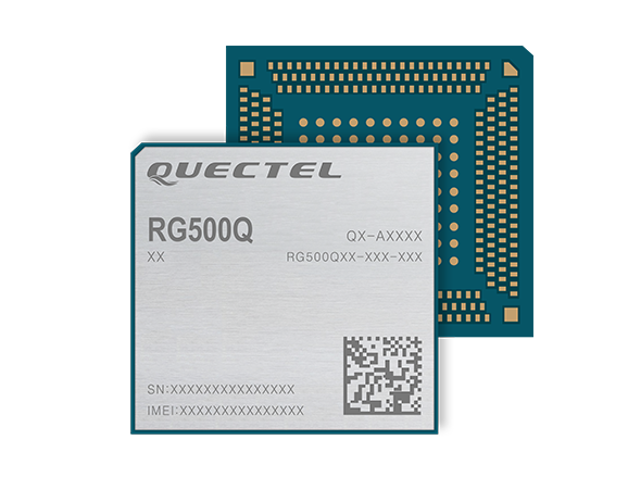
Quectel Wireless Solutions‘ RG500Q-EA 5G NR module has achieved commercial readiness and is now available to support global customers with mass deployment.
The module features the Qualcomm Snapdragon X55 5G modem. It is designed for a variety of industrial and consumer internet of things (IoT) applications, including business routers, home gateways, customer premises equipment (CPE), MiFi, industrial IoT (IIoT), industrial laptops, PDAs, video surveillance, digital signage, 4K/8K live streaming and many other bandwidth-intensive use cases.
The Quectel RG500Q-EA supports major sub-6GHz frequency bands as well as worldwide LTE-A and WCDMA network coverage, allowing customers to deploy their IoT solutions flexibly in Asia-Pacific, Europe and the Middle East.
Quectel RG500Q is a series of 5G Sub-6GHz modules optimized specially for IoT and M2M applications. Adopting the 3GPP Rel. 15 technology, it supports both 5G NSA and SA modes.
The RG500Q is provided in two variants: RG500Q-EA and RG500Q-NA. The module supports Qualcomm IZat location technology Gen9C Lite (GPS, GLONASS, BeiDou/Compass, Galileo and QZSS). The integrated GNSS receiver greatly simplifies product design and provides quicker, more accurate and more dependable positioning capability.
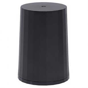
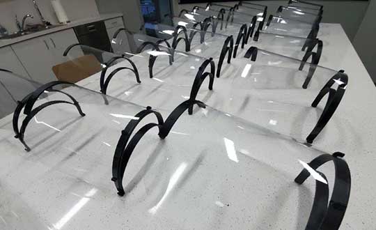
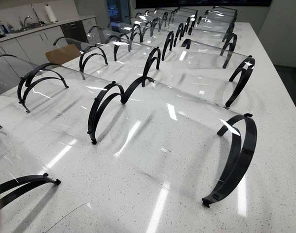
Tallysman Wireless Inc. has added the HC977 triple-band GNSS antenna to its helical antenna family.
HC977 GNSS antenna. (Photo: Tallysman)
The HC977 includes all signals covered by the HC975: GPS/QZSS-L1/L2/L5, GLONASS-G1/G3, Galileo-E1/E5a/E5b, BeiDou-B1/B2/B2a, IRNSS-L5 and L-Band correction services, and also provides reception of GLONASS-G2.
Tallysman helical antennas are designed for high-accuracy applications where precision and light weight matter, such as unmanned aerial vehicles (UAVs). The antennas are available in either a robust IP67 enclosure or an embedded format.
HC977E GNSS antenna. (Photo: Tallysman)
The HC977 features a low current, low noise amplifier (LNA) that includes an integrated low-loss pre-filter to protect against harmonic interference from high amplitude interfering signals, such as 700-MHz band LTE and other near in-band cellular signals.
The antenna is protected by a robust, military-grade plastic enclosure with an integrated SMA connector for screw-on mounting that securely seals the unit with an O-ring, complying with IP67 standards. The enclosure also provides three threaded holes in the base for secure attachment of the unit.
For the embedded version, HC977, Tallysman provides an embedded helical antenna mounting ring that traps the outer edge of the circuit board to another circuit board or to any flat surface. To facilitate a successful installation and optimum antenna performance, Tallysman also provides an Embedded Helical Antenna Installation Guide.
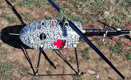
UAVOS has successfully tested its cargo delivery UVH-170 unmanned helicopter. The trial aimed to validate a highly automated delivery flight from a vendor to a destination and back, across precisely pre-selected pathways.
The flight took 1.7 hours and covered a standoff distance of 62 miles (100 kilometers). Critical humanitarian aid weighing 17.6 lbs (8 kg) was delivered with neither the need to land nor the need for a ground-control station on the receiving side.
UAVOS’s UAS is equipped with line-of-sight data link (LOS) and satellite communication data link, which supports beyond visual line of sight (BVLOS) flights. Watch the cargo delivery UVH-170 UAV in action.
UVH-170 unmanned helicopter is designed for commercial operations and immediate air response, emergency relief under demanding conditions and tight timescales. The aircraft’s high standoff distance makes it well-suited to humanitarian and disaster relief applications.
The capabilities of the UVH-170 unmanned helicopter address many social (medical, pharmaceutical, remote communities, humanitarian aid, etc.) and economic (mining, oil and gas, courier, etc.) use-cases being requested by customers.
The solution is based on the gasoline engine UVH-170 unmanned helicopter. With a maximum take off weight of 99 lb (45 kg), and a payload of up to 22 lb (10 kg), the UVH-170 flies at an altitude of less than 8,200 ft (2,500 m) at maximum speed of 74 mph (120 kph).
“As we have seen during the trials, the customers can derive significant benefits from the use of the UVH-170 UAV,” said Aliaksei Stratsilatau, CEO and Lead Developer of UAVOS. “As a robust VTOL platform, the UVH-170 does not require any additional take off or recovery equipment, which makes it perfect for delivery to remote areas. Besides, the unmanned helicopter has demonstrated capability to operate in windy conditions with gusts more than 14 mps.”
UAVOS has offices in Hong Kong, the United States and Europe. Among UAVOS’ unmanned technologies is the high-altitude pseudo-satellite (HAPS) ApusDuo, multi-platform autopilot solution for converting manned vehicles of all types into unmanned, and unmanned aerial vehicles aimed to counteract systems of electronic warfare.
Feature photo: UVH-170 unmanned helicopter is designed for immediate deliveries. (Photo: UAVOS)
With the rise in public unrest from COVID-19 and increasing numbers of remote operations, the susceptibility and vulnerability of a cyber attack has never been greater.
On a regular basis, we hear intelligence experts proselytize an eventual cyber doomsday where our critical infrastructure (CI) — communications systems, information technology (IT) capabilities and financial networks — are compromised or disabled. These kinds of attacks could devastate our national and economic security and even disrupt basic day-to-day activities like turning on lights or buying groceries with a debit card. Even worse, a significant cyber event could escalate to the point of military actions between nation-states.
In 2012, Defense Secretary Leon Panetta warned about a potential “Cyber Pearl Harbor.” These threats were echoed by then head of Cyber Command, Gen. Keith Alexander, with hope the public, private and CI sectors would take notice of the broad, detrimental impacts of cyber threats.
Geoff Hella, Centauri Corp.
In kind, the Obama administration took aggressive steps to protect CI networks, and the Trump White House followed suit by enacting measures to strengthen the resilience of other technologies integral to our CI.
The latest White House Executive Order specifically addresses our reliance on position, navigation and timing (PNT) services and directs agencies to work in close coordination with the private sector to identify, secure and continue to improve the resilience of these technologies.
PNT services, such as GPS, are an extension of our IT systems, but despite this, PNT has been a relatively invisible utility and is oftentimes unknowingly utilized by most CI owners and operators. In the coming years, our reliance on PNT will only increase, making now a critical time to foster close collaboration between public and private sectors and determine which systems, networks and assets are dependent on PNT services. Identifying these dependencies will allow us to verify appropriate resilient PNT services being used, determine downstream effects of the disruption and manipulation of PNT services, and manage the associated risks to dependent systems.
The new directive is fast paced — outlined in 90-, 180- and 360-day increments — and instructs agencies to utilize existing public-private sector cybersecurity and CI information sharing relationships, such as Sector Specific Agencies (SSA), to share threat data, educate stakeholders and promote a responsible use of PNT.
What’s the rush?
So, why is this happening right now? PNT systems are crucial to American life, and successfully securing them requires a coordinated response and sooner rather than later. In fact, malicious nation-states, such as Russia, are spreading their wings into new threat vectors to inflict damage and are shifting their attention to PNT.
Because of these risks, we must do more as a country to establish safeguards around these technologies. That being said, agencies and organizations cannot expect their current workforce to become PNT security experts overnight. Rather, business owners and operators would be better served bringing in third-party experts that have been building security into PNT even prior to this directive.
These private-sector partners can map out a systematic approach to prioritize PNT security in a three-step plan:
Find. Identify PNT systems and “profile” them — establish point A.
Fix. Find and correct vulnerabilities — many can be non-material/tactics, technique and procedures (TTP) solutions.
Fortify. Develop TTPs, timelines and guidance for users to upgrade CI where needed — the path to Point B.
When PNT services were first developed, the systems could be openly used by anyone and security was not built into the original PNT architecture — similar to when the internet was created. This has made it easy for adoption into almost everyday life and revolutionized the world. Likewise, it has also made it easy for bad actors to access and compromise it, forcing the country to scramble, backtrack and implement cybersecurity best practices.
The good news is that we aren’t completely starting from scratch. The Department of Defense has been working to secure its PNT systems and will be updating its processes and practices as part of the recent White House directive.
The security community can also look to best practices in assessing risk of vital systems and model PNT security measures on existing guidelines such as Federal Information Processing Standards (FIPS) and NIST Special Publication 800 Series.
Path Forward
Per the Executive Order, lead agencies such as the Department of Transportation and the Department of Commerce will work in concert with the private sector to define “PNT profiles” and share these attributes with stakeholders. The coalition of partners will then be able to account for where and how PNT is used by CI owners and operators and will promote the responsible use of PNT services moving forward.
Beyond defining PNT profiles, the EO allocates new research and development funding for Commerce to develop an alternative to GNSS, which provides real-time PNT data to planes, trains, ships and automobiles that transport vital goods and resources — all in an effort to reduce the level of acceptable risk.
The White House also requires the public and private sectors to develop vulnerability testing and incident response plans and, simultaneously, encourage the private sector to use and develop more robust PNT services in anticipation of new Federal Acquisition Regulatory Council (FARC) contract requirements.
While these changes may seem like a fast moving and overwhelming process, there are many cases where CI owners and operators will not be required to integrate material solutions, but rather procedural training and behavioral adjustments. The information sharing processes already exist to provide improved situational awareness, coordination among the public and private sectors, increased reporting, solidified baseline risk assessments and a broader understanding of how systems rely on PNT. The challenge is facilitating widespread adoption across all stakeholders, increasing collaboration and education among and across the CI groups.
For this effort to be successful, it will require a whole-community, multi-pronged approach to operating in a new “threat top-of-mind” paradigm that is grounded on cross-sector information sharing, training and education. Both public and private sectors should also outsource expertise and leverage existing models like the DoD PNT doctrine, NIST standards and incident response capabilities.
Gregory Gerten is director of PNT Operations at Centauri, supporting the PNT enterprise through innovative use of modeling and simulation, hardware-in-the-loop and field testing, and process automation. He earned his master’s degree in electrical engineering from the University of Dayton, and has completed post-graduate courses in GPS from the Air Force Institute of Technology. He has more than 20 years of experience in system design, development and integration in the areas of communications, navigation, electronic warfare tactics and weapon systems.
Geoffrey Hella is a senior engineer for Centauri assigned to a Space Command contract through the Joint Navigation Warfare Center (JNWC). He has worked to achieve a Master of Aeronautical Science (MAS) from Embry-Riddle Aeronautical University in 1994. During his 40 years of experience, he has been a leader in product development and system design to successfully carry out a vast range of assignments in multiple engineering disciplines. His assignments include: aircrew member of the United States Air force (USAF); National Air Space (NAS) engineer for the Federal Aviation Administration (FAA); Special Nuclear testing and safeguards engineer for the Department of Energy/Sandia National Laboratories; and Supervisory Control and Data Acquisition (SCADA) engineer for both public and private Industry, electric and gas utility companies. Hella currently holds a six-sigma certification and a general radio operator license from the Federal Communication Commission (FCC) and a remote pilot operator certificate from the Federal Aviation Administration (FAA).
Verizon will integrate TomTom’s Maps application programming interfaces (API) and software development kits (SDK) into its location-services offering, making it easier for the developer community to build upon and integrate the platform. The developers’ portal is available at developer.tomtom.com. More information from
The agreement is an expansion of the existing TomTom and Verizon agreement, where TomTom provides location-based services to enhance Verizon’s current suite of location-based data, navigation, and intelligence.
“We look forward to continuing to build upon and evolve our product suite with TomTom’s technology,” said Jeff Frantz, executive director, Verizon Location Services. “By expanding our agreement, we are furthering our commitment to providing best-in-breed location technology for Verizon and our customers.”
“We’re determined to make it as easy as possible for developers to have access to our Maps APIs and SDKs so we’re delighted that Verizon is offering TomTom products to their location-services customers,” said Anders Truelsen, managing director, TomTom Enterprise.
5G and HD Maps. In the last quarter of 2019, the companies also announced an innovation project using Verizon 5G Ultra Wideband and TomTom HD Maps to help make intersections safer for emergency vehicles.
New tests instituted to stop COVID-19 infection at crew change in response to new European Union and and International Maritime Organization (IMO) guidelines
The European Union and International Maritime Organization (IMO) have issued new guidelines requiring ship operators to implement pre-boarding screening of seafarers.
To assist ship operators comply with these important new guidelines and help protect their vessels from an outbreak of COVID-19, Martek Marine has launched the CoronaSafe finger prick antibody screening test.
From a single drop of blood, CoronaSafe will detect IgM antibodies within 5-7 days of infection. It is particularly useful for detecting infections among subjects who show no symptoms and would otherwise embark undetected.
A study into the COVID-19 outbreak on the cruise ship Diamond Princess estimated that 20.6%-39.9% of cases were asymptomatic, while a study published in the British Medical Journal concluded that up to four-fifths of cases are asymptomatic.
The CoronaSafe test is approved and certified by the European Union as meeting the safety, quality and performance requirements of Standard IVDD 98/79/EC — the highest standard applicable for these devices. It is also in wide-scale use by authorities and corporations in Japan, China, Germany, Poland and Indonesia, and is formally certified by CFDA, Philippines FDA and Singapore Health Sciences Authority.
“Screening crew before boarding is a critical step to prevent avoidable transmission from an asymptomatic crew member,” said Martek CEO Paul Luen. “It’s also an important diagnostic tool for re-screening after leaving or if someone shows symptoms. The effect of an outbreak on a ship could be catastrophic in both business and human terms.”
Major corporations worldwide are rushing to adopt these occupational screening tests to help control the spread of this deadly virus, with demand rising rapidly as the crisis deepens.
Martek, which has limited supply of the tests, are urging shipowners to act quickly to define their policy for crew screening, to maintain the health of their employees and ensure continuation of their shipping operations.
Radius Telematics has seen a big increase in the thefts of commercial vehicles since the coronavirus lockdown. With many offices, factories and construction sites unattended, thieves appear to be taking advantage of unattended locations.
According to Radius, vehicles and plant not equipped with GPS security devices that detect and track unauthorized movement are especially vulnerable as the thefts may go unreported for many days or even weeks.
Radius Telematics acquired two companies in 2019 that had a substantial proportion of their business in vehicle and plant security — both are reporting significant spikes in thefts.
Radius Telematics encompasses telematics brands Kinesis, UK Telematic, Plant-I, Sure-Track, CyntrX and Key Telematics. Altogether, Radius companies track more than 250,000 vehicles across the globe, with security devices fitted to 27,000 assets ranging from generators to vans, mini-diggers and earth moving trucks.
Many are equipped with Theft Recovery Trackers, small covert wireless devices with movement and tamper alarms. Once activated, the asset is automatically tracked to ensure that stolen assets are recovered quickly and efficiently.
“From security tracker alerts, we have seen a doubling in plant and van theft since the lockdown began,” said said Greville Coe, managing director of Radius Telematics. “It’s incredible that when we are all self-isolating and worrying about a deadly virus, crime is being committed while people and organizations are so vulnerable.”
Photo: Radius Telematics
One particularly disturbing theft was of a van stolen from a hospice for the terminally ill. The incident in Coventry, UK, saw a property belonging to a hospice ransacked and the theft of a hospice van. Fortunately, the vehicle was fitted with a Sure-Track tracker previously donated by Radius Telematics and the vehicle was safely recovered after three days. The Wireless Theft Recovery Tracker allowed the Radius nationwide finder network to accurately track the movements and whereabouts of the stolen vehicle.
“It’s shocking that thieves would target a charity caring for the terminally ill in what is an exceptionally difficult time,” Coe said. “Radius Telematics tracking services remain fully operational irrespective of the travel and business restrictions imposed due to the Coronavirus crisis. We hope we can help to ensure that essential services can be delivered with minimal disruption.”
Radius Telematics is a newly branded group formed within Radius Payment Solutions. The new telematics division incorporates a number of telematics-related businesses including their own Kinesis-branded vehicle tracking and previous acquisitions including Plant-i, UK Telematics and Sure-Track.
D.C.-area engineering firm produces reusable face shields for region’s hospitals, offers sterile 3D printer patent for COVID applications globally
The team of engineers at Robotic Research LLC, based in Clarksburg, Maryland, is applying its innovative engineering expertise to create new solutions for healthcare workers to help fight the COVID-19 crisis in the Washington area and around the world.
Robotic Research is a provider of autonomy and robotic technologies for government and commercial customers.
The company has created a unique design for reusable face shields and is providing the shields to healthcare teams in hospitals around the Greater Washington Metro area. The company also just opened up its patented design of its sterile 3D printer by waiving licensing fees globally for any application of the printers related to fighting the current public health pandemic.
Face shields
Face shield printed for health-care workers to help fight COVID-19. (Photo: Robotic Research)
The face shields, which Robotic Research is printing on standard industrial 3D printers at its robotics engineering facility in Clarksburg, are being delivered to support teams at hospitals in the Montgomery County area.
The face shield design provides comfort and protection, and features an improved disinfection process capability using materials compatible with hospital cleaning methods. The design has been approved for use in select departments, with broader uses under evaluation.
“Our team wanted to help out in any way we could to support the local frontline health-care providers who are working around the clock to assist those impacted by the COVID-19 public health crisis,” said Alberto Lacaze, president of Robotic Research. “We are producing a face shield that modifies a design based off the blueprint provided by the National Institutes of Health. The design includes some enhancements to further protect from aerosol in the temple area and allow the masks to be cleaned and therefore reusable, as well as comfortable to wear over prolonged use.”
Robotic Research has sourced materials from across the country to support the production of approximately 2,000 face shields. The company is seeking a grant through Montgomery County and the state of Maryland to boost production to approximately 500 shields a day. The company normally uses its standard 3D printers to support many of its robotic products and solutions.
Sterile 3D printer
A batch of face shields prepared fo delivered to a Maryland hospital. (Photo: Robotic Research)
Materials used for polymer 3D printing are often damaged by the high temperatures, chemicals or radiation used in standard sterilization processes. Robotic Research’s patented process overcomes this challenge by using a sterile chamber around a 3D printer where unsterilized plastic is brought into the chamber.
The possibly contaminated plastic is sterilized by the printing process and packaged maintaining the sterile field.
This system was initially designed for a U.S. government agency to allow sterile medical materials to be printed at locations where commonly used sterilization methods might not be possible.
“Because this printer can create sterile materials, which are sterile from the inside out once produced, we are eliminating the need for hospitals to re-sterilize equipment before use,” Lacaze said. “At a time when efficiency and supplies are critical, we hope this technology will be able to help alleviate some of the immense pressure hospitals and medical facilities are currently facing. It is our hope that providing the use of this process at no cost may help bring solutions to the health care teams working to save lives during this crisis.”
The unique printer process enables the manufacturing of sterile medical equipment and implantable device components, such as intubation tubes and other materials required during invasive procedures, in a manner that eliminates the need for additional sterilization.
Robotic Research’s patented sterile 3D printing process (USPTO 10,406,758) will be available royalty-free for a minimum of one year for any COVID-19 applications across the globe.
The company is committed to continuing to use its resources and facilities to develop solutions for the ongoing challenges of the COVID-19 pandemic.